kl155k ass 1 intr prehistory
TRANSCRIPT
8/7/2019 KL155K Ass 1 Intr Prehistory
http://slidepdf.com/reader/full/kl155k-ass-1-intr-prehistory 1/6
Andrew David Sturdy Introduction to Prehistoric ScotlandStudent ID: 5080099 KL155K Assignment 1
March 2011
1
Q. With reference to a single period of prehistory, outline what we know, suggest what we ought to
know, and indicate how you would try to gain this knowledge.
‘When dealing with History, it is not sufficient to know where events took place, we must try to find
out why there? Learn the geography of your district, learn its History at the same time, and see how far the
latter is dependent upon the former.’ Eranest T.W. Dann 1908
i
It has been largely accepted that the period of the Late Upper Palaeolithic to early Mesolithic, 12000 –
7000 BC, in Aberdeenshire was void of human activity. The reasoning being given was that very little
archaeological evidence has ever been gathered to the contrary. But with more recent finds and our ever
increasing understanding of geology and past environment being gained by advancements in the
archaeology sciences, (geophysical, sonar radar, DNA, isotopic etc). Is it time to revaluate what we have
learnt and modify our appreciation of Man’s activity during this period in this area?
Why single out Aberdeenshire? Well Aberdeenshire’s boundaries are still representative of a specific
geological area. Separated from central Scotland by the Month or Eastern Grampians, and bonded on twosides by the sea, the territory which forms Aberdeenshire between the rivers Dee and the Spey has always
given it a position of comparative isolation from the rest of the country. Trying to look at this period on the
scale of a modern nation like Scotland would require more than this essay could hope to deliver; and after
all, human behaviour at this time was being highly influenced by the landscape and each location must be
judge by its own unique topography. How the environment was conditioning human activity in Western
Scotland must have been different to how it affected those in the North East purely on geography grounds.
By adapting Dann’s statement above to read, ‘Learn the geography of your district and you will also learn
its Prehistory.’ We have a foundation to start looking for evidence with.
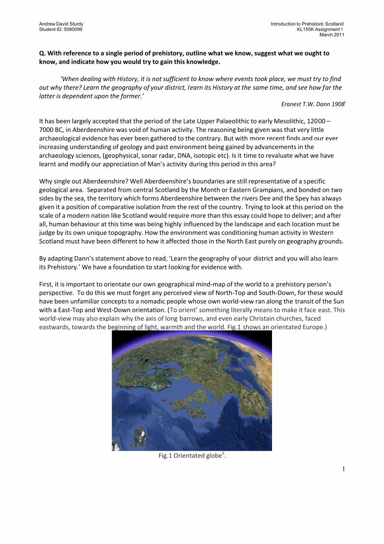
First, it is important to orientate our own geographical mind-map of the world to a prehistory person’sperspective. To do this we must forget any perceived view of North-Top and South-Down, for these would
have been unfamiliar concepts to a nomadic people whose own world-view ran along the transit of the Sun
with a East-Top and West-Down orientation. (To orient’ something literally means to make it face east. This
world-view may also explain why the axis of long barrows, and even early Christain churches, faced
eastwards, towards the beginning of light, warmth and the world. Fig.1 shows an orientated Europe.)
Fig.1 Orientated globeii.
8/7/2019 KL155K Ass 1 Intr Prehistory
http://slidepdf.com/reader/full/kl155k-ass-1-intr-prehistory 2/6
Andrew David Sturdy Introduction to Prehistoric ScotlandStudent ID: 5080099 KL155K Assignment 1
March 2011
2
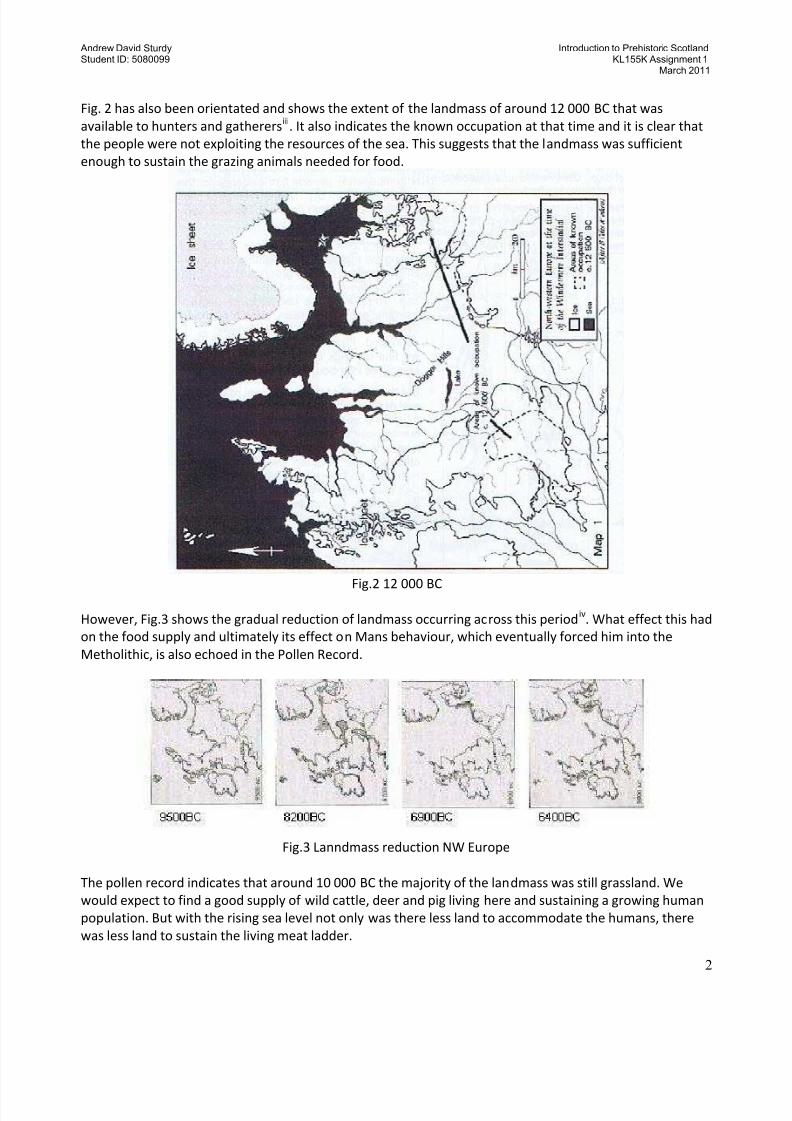
Fig. 2 has also been orientated and shows the extent of the landmass of around 12 000 BC that was
available to hunters and gatherersiii
. It also indicates the known occupation at that time and it is clear that
the people were not exploiting the resources of the sea. This suggests that the landmass was sufficient
enough to sustain the grazing animals needed for food.
Fig.2 12 000 BC
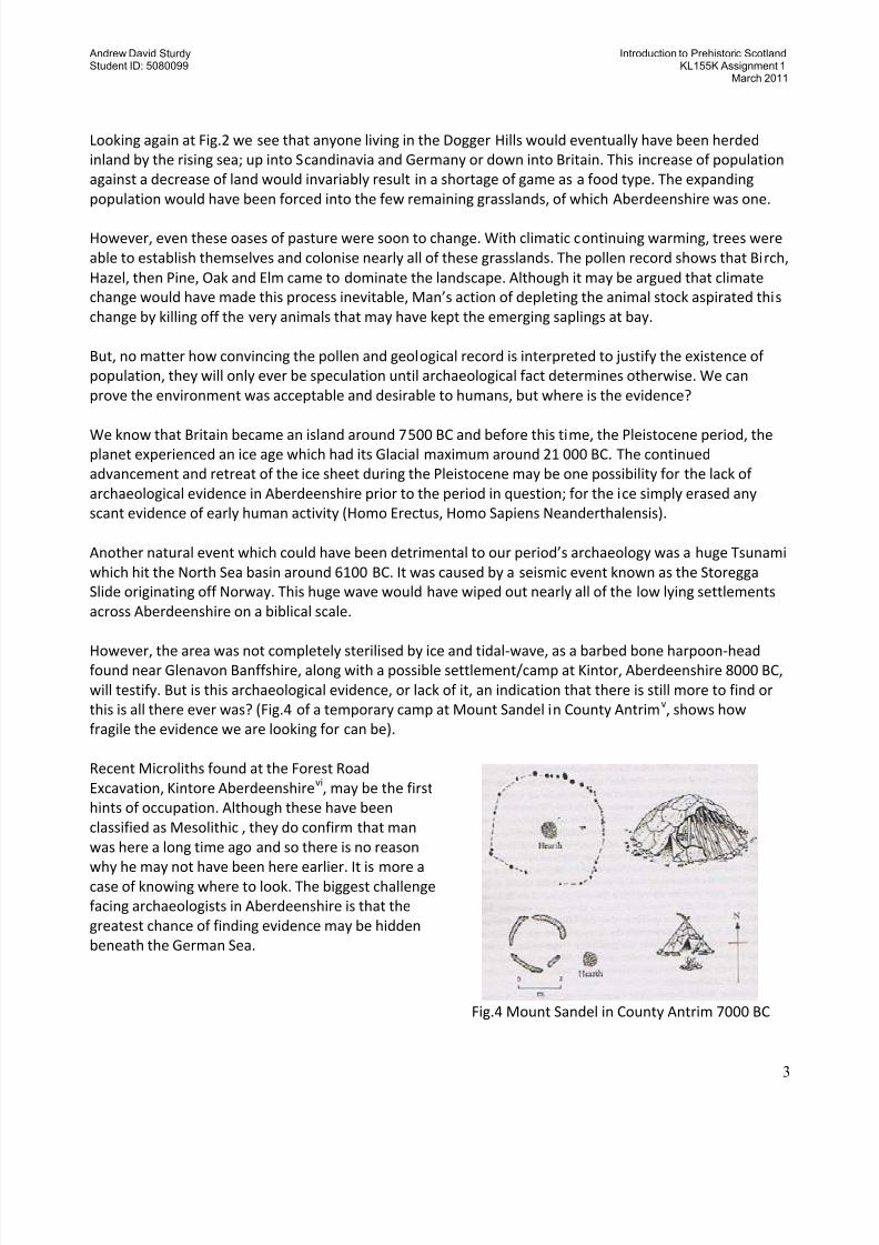
However, Fig.3 shows the gradual reduction of landmass occurring across this periodiv. What effect this had
on the food supply and ultimately its effect on Mans behaviour, which eventually forced him into the
Metholithic, is also echoed in the Pollen Record.
Fig.3 Lanndmass reduction NW Europe
The pollen record indicates that around 10 000 BC the majority of the landmass was still grassland. We
would expect to find a good supply of wild cattle, deer and pig living here and sustaining a growing human
population. But with the rising sea level not only was there less land to accommodate the humans, there
was less land to sustain the living meat ladder.
8/7/2019 KL155K Ass 1 Intr Prehistory
http://slidepdf.com/reader/full/kl155k-ass-1-intr-prehistory 3/6
Andrew David Sturdy Introduction to Prehistoric ScotlandStudent ID: 5080099 KL155K Assignment 1
March 2011
3
Looking again at Fig.2 we see that anyone living in the Dogger Hills would eventually have been herded
inland by the rising sea; up into Scandinavia and Germany or down into Britain. This increase of population
against a decrease of land would invariably result in a shortage of game as a food type. The expanding
population would have been forced into the few remaining grasslands, of which Aberdeenshire was one.
However, even these oases of pasture were soon to change. With climatic continuing warming, trees were
able to establish themselves and colonise nearly all of these grasslands. The pollen record shows that Birch,
Hazel, then Pine, Oak and Elm came to dominate the landscape. Although it may be argued that climate
change would have made this process inevitable, Man’s action of depleting the animal stock aspirated this
change by killing off the very animals that may have kept the emerging saplings at bay.
But, no matter how convincing the pollen and geological record is interpreted to justify the existence of
population, they will only ever be speculation until archaeological fact determines otherwise. We can
prove the environment was acceptable and desirable to humans, but where is the evidence?
We know that Britain became an island around 7500 BC and before this time, the Pleistocene period, theplanet experienced an ice age which had its Glacial maximum around 21 000 BC. The continued
advancement and retreat of the ice sheet during the Pleistocene may be one possibility for the lack of
archaeological evidence in Aberdeenshire prior to the period in question; for the ice simply erased any
scant evidence of early human activity (Homo Erectus, Homo Sapiens Neanderthalensis).
Another natural event which could have been detrimental to our period’s archaeology was a huge Tsunami
which hit the North Sea basin around 6100 BC. It was caused by a seismic event known as the Storegga
Slide originating off Norway. This huge wave would have wiped out nearly all of the low lying settlements
across Aberdeenshire on a biblical scale.
However, the area was not completely sterilised by ice and tidal-wave, as a barbed bone harpoon-headfound near Glenavon Banffshire, along with a possible settlement/camp at Kintor, Aberdeenshire 8000 BC,
will testify. But is this archaeological evidence, or lack of it, an indication that there is still more to find or
this is all there ever was? (Fig.4 of a temporary camp at Mount Sandel in County Antrimv, shows how
fragile the evidence we are looking for can be).
Recent Microliths found at the Forest Road
Excavation, Kintore Aberdeenshirevi, may be the first
hints of occupation. Although these have been
classified as Mesolithic , they do confirm that man
was here a long time ago and so there is no reason
why he may not have been here earlier. It is more acase of knowing where to look. The biggest challenge
facing archaeologists in Aberdeenshire is that the
greatest chance of finding evidence may be hidden
beneath the German Sea.
Fig.4 Mount Sandel in County Antrim 7000 BC
8/7/2019 KL155K Ass 1 Intr Prehistory
http://slidepdf.com/reader/full/kl155k-ass-1-intr-prehistory 4/6
Andrew David Sturdy Introduction to Prehistoric ScotlandStudent ID: 5080099 KL155K Assignment 1
March 2011
4
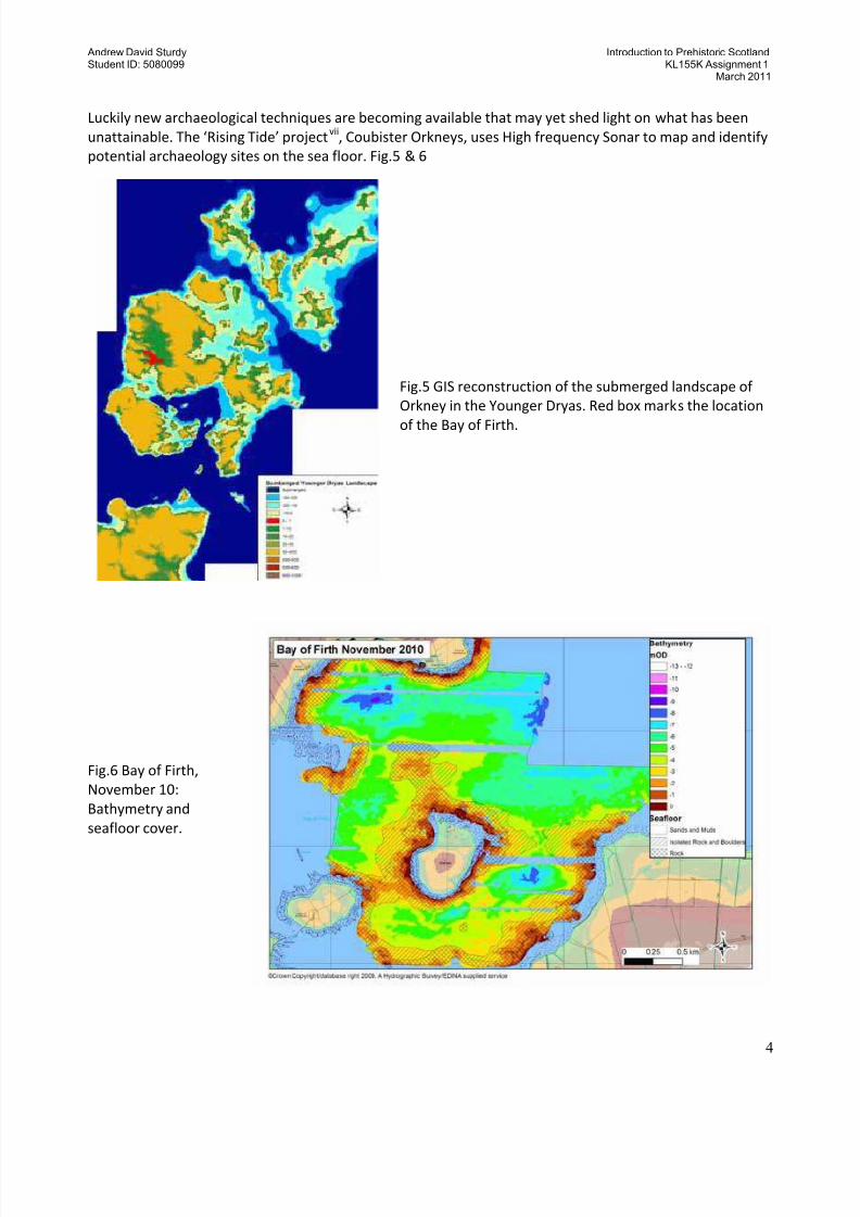
Luckily new archaeological techniques are becoming available that may yet shed light on what has been
unattainable. The ‘Rising Tide’ projectvii
, Coubister Orkneys, uses High frequency Sonar to map and identify
potential archaeology sites on the sea floor. Fig.5 & 6
Fig.5 GIS reconstruction of the submerged landscape of
Orkney in the Younger Dryas. Red box marks the location
of the Bay of Firth.
Fig.6 Bay of Firth,
November 10:
Bathymetry and
seafloor cover.
8/7/2019 KL155K Ass 1 Intr Prehistory
http://slidepdf.com/reader/full/kl155k-ass-1-intr-prehistory 5/6
Andrew David Sturdy Introduction to Prehistoric ScotlandStudent ID: 5080099 KL155K Assignment 1
March 2011
5
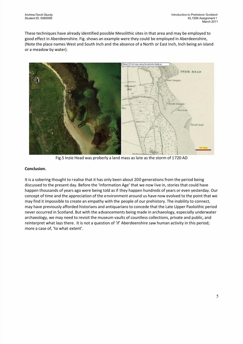
These techniques have already identified possible Mesolithic sites in that area and may be employed to
good effect in Aberdeenshire. Fig. shows an example were they could be employed in Aberdeenshire,
(Note the place names West and South Inch and the absence of a North or East Inch, Inch being an island
or a meadow by water).
Fig.5 Inzie Head was proberly a land mass as late as the storm of 1720 AD
Conclusion.
It is a sobering thought to realise that it has only been about 200 generations from the period beingdiscussed to the present day. Before the ‘Information Age’ that we now live in, stories that could have
happen thousands of years ago were being told as if they happen hundreds of years or even yesterday. Our
concept of time and the appreciation of the environment around us have now evolved to the point that we
may find it impossible to create an empathy with the people of our prehistory. The inability to connect,
may have previously afforded historians and antiquarians to concede that the Late Upper Paoloithic period
never occurred in Scotland. But with the advancements being made in archaeology, especially underwater
archaeology, we may need to revisit the museum vaults of countless collections, private and public, and
reinterpret what lays there. It is not a question of ‘if’ Aberdeenshire saw human activity in this period;
more a case of, ‘to what extent’.

8/7/2019 KL155K Ass 1 Intr Prehistory
http://slidepdf.com/reader/full/kl155k-ass-1-intr-prehistory 6/6
Andrew David Sturdy Introduction to Prehistoric ScotlandStudent ID: 5080099 KL155K Assignment 1
March 2011
6
i Dann T.W. Ernest 1908, ‘Historical Geography on a Regional Basisi,’ Dent’s series of Mathematical & Scientific
Text Books for Schools ii
Google maps, internetiii
Kl155K workbook pg 27, (jbk after B coles et al)iv Francis Pryor, Britain BC, pg 108v
Francis Pryor, Britain BC, pg 98viKintore: A Sumamry of Archaeological Work, Aberdeenshire Council
viiThe Rising Tide, submerge landscape of the Orkneys, S Dawsoni & CR Wickham-Jones