raport de analiza privind potentialul tehnic · pdf fileanaliza potentialului tehnic ......
TRANSCRIPT
1 | P a g i n a
RAPORT DE ANALIZA PRIVIND
POTENTIALUL TEHNIC SI STIINTIFIC
EXISTENT IN REGIUNEA DUNARII,
RELEVANT PENTRU MANAGEMENTUL
INTEGRAT AL SISTEMELOR FLUVIU –
DELTA – MARE Pachet de Lucru # 2
Analiza potentialului tehnic si stiintific existent in Regiunea Dunarii, relevant pentru managementul integrat al
sistemelor fluviu – delta – mare
Autori: GEOECOMAR INSB FM Management Consultancy SRL GEA Strategy & Consulting SA
Experti: Dr. Adrian Stănică Dr. Manuela Sidoroff Dr. Simona Lițescu Dr. Mihaela Păun Mădălin Ioniță Lavinia Cioară Virgil Dinulescu Dana Beșliu Flaviana Rotaru Dragoș Pîslaru Adriana Constantinescu Tanislav Manta Albert Scrieciu Bogdan Alexandrescu
Iunie 2014
2 | P a g i n a
CUPRINS
CUPRINS .......................................................................................................................................................... 2
1. INTRODUCERE ....................................................................................................................................... 4
2. METODOLOGICA APLICATĂ .............................................................................................................. 5
3. CONSTRÂNGERI ALE RAPORTULUI DE ANALIZĂ ...................................................................... 10
4. CENTRUL PENTRU STUDII AVANSATE “DANUBIUS” ................................................................ 12
4.1. DESCRIEREA CENTRUL PENTRU STUDII AVANSATE “DANUBIUS” ............................... 12
4.2. Descrierea Infrastructurii................................................................................................................. 13
4.3. Descrierea agendei stiintifice .......................................................................................................... 17
4.4. Descrierea Managementului DANUBIUS-RI şi a procesului de Guvernanţă ................................ 23
5. POTENTIALUL TEHNIC SI STIINTIFIC EXISTENT IN REGIUNEA DUNARII, RELEVANT
PENTRU MANAGEMENTUL INTEGRAT AL SISTEMELOR FLUVIU – DELTA – MARE ................. 27
5.1. Analiza infrastructurilor de cercetare existente in Regiunea Dunarii, relevante pentru mangementul
integrat al sistemelor fluviu – delta – mare ................................................................................................. 27
5.2. Analiza programelor de cercetare in curs si agendei stiintifice, existente in Regiunea Dunarii,
relevante pentru managementul integrat al sistemelor fluviu – delta – mare .............................................. 29
5.2.1. Cercetari din ciclul apei coordonate de tari din regiunea Dunarii Mijlocii si de Jos si din
regiunea Dunarea de Jos-Delta Dunarii-Coasta de Vest a Marii Negre ........................................ 29
5.2.2. Programe de cercetare din cilcul apei coordinate de catre tari din regiunea Dunarii Superioare
si alte tari ( Europa si SUA) .......................................................................................................... 34
5.3. Analiza programelor de dezvoltare a resursei umane specializate in mamagementul integrat al
sistemelor rau-delta-mare implementate in regiunea Dunarii ..................................................................... 42
5.4. Analiza potentialului tehnic si stiintific al infrastructurilor de cercetare din Regiunea Dunarii si
relevant pentru managementul integrat al sistemelor fluviu – delta – mare ................................................ 46
5.5. Analiza principalelor puncte tari si puncte slabe ale infrastructurii de cercetare din Regiunea
Dunarii, relevante pentru managementul integrat al sistemelor fluviu – delta – mare (infrastucturi de
cercetare, agenda stiintifica si dezvoltarea resursei umane) ...................................................................... 47
6. CONCLUZII SI RECOMANDARI ....................................................................................................... 49
7. ANEXE ................................................................................................................................................... 53
7.1. Analiza potentialului tehnic si stiintific relevant, existent in Regiunea Dunarii ............................. 53
7.1.1. Anexa 1 – Lista principalelor infrastructuri, programe si initiative din Regiunea Dunarii 53
7.1.2. Anexa 2 – Descrierea potentialului tehnic si stiintific al infrastructurilor existente,
programelor si initiativelor din Regiunea Dunarii (selectii) ....................................................... 114
7.2. Conferinta Internationala “Potentialul tehnico-stiintific privind managementul integrat al
sistemului Dunare – Delta Dunarii – Marea Neagra. Realitati si planuri pentru viitor” 17-18.03.2014 ... 125
7.2.1. Anexa 3 - Minuta intalnirii .......................................................................................... 125
3 | P a g i n a
7.3. Seminar International „Cresterea colaborarii dintre comunitatea stiintifica si mediul de afaceri din
Regiunea Dunarii. Noi oportunitati” 19-20.03.2014 ................................................................................. 141
7.3.1. Anexa 4 – Minuta intalnirii ......................................................................................... 141
7.4. Atelierul International: „Suport stiintific in luarea de decizii in managementul apei din Regiunea
Dunarii” 25-26.05.2014 ............................................................................................................................ 156
7.4.1. Annex 5 – Minuta intalnirii ......................................................................................... 156
8. BIBLIOGRAFIE ................................................................................................................................... 182
4 | P a g i n a
1. INTRODUCERE
Acest raport are ca scop principal realizarea unei analize detaliate a potențialului de cercetare tehnico-
ştiinţific existent in Regiunea Dunării, relevant pentru managementul integrat al sistemelor de tip fluviu-
deltă-mare (FDM).
Centrul Internaţional pentru Studii Dunare- Delta Dunării - Marea Neagra (DANUBIUS - RI) va fi propus
pentru a fi inclus pe viitoarea foaie de parcurs ESFRI ca infrastructura de cercetare majoră pan-europeană în
domeniul managementului integrat al sistemelor de tip fluviu-deltă-mare, cu accent pe macrosistemul
Dunăre-Marea Neagră. Propunerea DANUBIUS-RI va trebui depusa în cadrul următoarei competiţii de
proiecte pentru următoarea foaie de parcurs a ESFRI (apel asteptat pentru următoarea competitie ESFRI - in
prima jumătate a anului 2014).
Se prevede ca DANUBIUS – RI să cuprindă un Nucleu în Delta Dunării – având rolul de centru de comandă
şi un rol major ca infrastructura de cercetare (transformând delta intr-un „laborator natural”), precum şi o
serie de Noduri în Europa. Noul Centru va contribui la cercetarea mediului si va promova inovarea in
regiunea extinsa a Dunării, inclusiv Delta Dunării si Marea Neagra. Aceste noduri vor da DANUBIUS-RI un
caracter de infrastructura distribuita si vor avea o contribuţie suplimentară în structura proiectului, dat fiind
faptul că vor aduce împreuna facilităţi de cercetare angajate în procese şi metodologii de cercetare din
întreaga Europă. Vor fi astfel aduse împreună ca noduri ale unei infrastructuri distribuite, cu nucleul central
in Delta Dunării, facilitati de cercetare de excelenta in diferitele problematici ale sistemelor FDM.
Misiunea centrului DANUBIUS-RI va fi aceea de a furniza soluţii ştiinţifice inovative, ca răspuns la
principalele provocări globale din domeniu şi de a stabili cadrul pentru dezvoltarea durabilă a sistemului
Dunăre – Delta Dunării – Marea Neagră, ca bună practică pentru sistemele majore de tip fluviu-deltă-mare la
nivel mondial.
În cadrul procesului de pregătire, România – în calitate de iniţiator al DANUBIUS - RI – necesită sprijinul
celorlalte State Membre ale UE, atât din interiorul, cât şi din exteriorul Regiunii Dunării. Ţările care se vor
alătura consorţiului DANUBIUS - RI vor fi selectate pe baza comunităţilor de cercetare puternice de care
dispun, capabile să contribuie în mod substanţial la dezvoltarea proiectului. Un element important de reţinut
în acest demers constă în nevoia de a dezvolta DANUBIUS-RI ca infrastructură de cercetare distribuită în
accepţia ESFRI şi nu ca o reţea de infrastructuri de cercetare– toate acestea abordând aceleaşi teme –
deoarece în acest caz ar putea fi asociată cu o „Iniţiativă de Infrastructuri Integrate” (I3). O eventuală
confuzie din acest punct de vedere ar putea conduce la respingerea DANUBIUS-RI în cadrul viitoarei Foi de
parcurs a ESFRI.
Obiectivul final al DANUBIUS - RI este de a deveni şi funcţiona ca Infrastructura de Cercetare pan-
europeană Distribuită cu acces deschis şi de a deveni „ERIC (European Research Infrastructure Consortium
- Consorţiu pentru o infrastructură europeană de cercetare)” din punct de vedere juridic.
5 | P a g i n a
Pentru a îndeplini aceste obiective, DANUBIUS-RI va numi o echipă de management la nivel internaţional,
va avea un Consiliu Ştiinţific şi un Consiliu General internaţional, cu participarea tuturor asociaţilor.
Prin Strategia Uniunii Europene pentru Regiunea Dunării (SUERD), DANUBIUS-RI a primit statutul de
Proiect Fanion în cadrul Domeniului Prioritar 7 „Societatea Bazată pe Cunoaştere” a SUERD (2 octombrie
2013). La nivel naţional, Guvernul României a considerat demersul de dezvoltare a DANUBIUS - RI şi a
Nucleului său din Delta Dunării drept un Proiect Major de Infrastructură de Cercetare, permiţând finanţarea
prin fonduri publice naţionale și structurale în perioada de programare 2014-2020.
2. METODOLOGICA APLICATĂ
Realizarea raportului de analiză privind potenţialul de cercetare tehnico-stiinţific existent în Regiunea
Dunării, relevant pentru managementul integrat al sistemelor de tip fluviu-deltă-mare, a necesitat o
componentă esenţială de cercetare susţinută.
În vederea îndeplinirii obiectivelor raportului, Consorţiul a aplicat mai multe instrumente de cercetare,
precum analiza documentară (literatura de specialitate relevantă, documente oficiale şi resurse de pe
internet), sondaje în rândul celor mai importanţi actori implicaţi, întâlniri de tip atelier cu experţi din
comunitatea ştiinţifică şi cea de afaceri, schimburi de idei între membrii Consorţiului.
Pe parcursul acestui demers, cercetarea a fost structurată în 5 etape:
Etapa I: Cercetare documentară a datelor existente
În cadrul acestui proces, Consorţiul a abordat un volum semnificativ de studii descriptive şi de explorare cu
privire la infrastructurile şi proiectele de cercetare existente în Regiunea Dunării, ce abordează potenţialul
existent în materie de infrastructură de cercetare, agendă ştiinţifică şi instruire. Versiunea actuală a raportului
se referă la potenţialul tehnico-stiinţific din partea cursului mijlociu si inferior al Regiunii Dunării, inclusiv
Delta Dunării, zona costiera si platforma continentala din vestul Mării Negre, aflate sub influenţa fluviului,
în timp ce versiunea finală va trata şi porţiunea centrală şi superioară a Regiunii Dunării.
Analiza documentară a implicat realizarea următoarelor activităţi: informare asupra proiectului pentru toţi
membrii echipei, identificarea surselor de informaţii, colectarea şi procesarea datelor, completarea fişelor de
date privind infrastructura cu referire la aspectele mai sus menţionate, interpretarea şi analiza datelor.
Sursele utilizate în vederea colectării informaţiilor au constat din: versiunea actualizată a Cărţii Albe, Cartea
Albastră (dezvoltata in cadrul acestei faze), resursele internet ale infrastructurilor de cercetare şi programelor
existente, rapoarte oficiale publicate pe pagina de internet a Comisiei Europene şi domeniul ESFRI, studii şi
rapoarte realizate de către membrii Consorţiului în cadrul altor proiecte (FP7 DANCERS), informaţii
furnizate în mod direct de către toţii partenerii din consorţiul DANUBIUS-RI.
Esantionul de date folosit pentru analiza in acest raport provine din rezultatele obtinute de proiectul FP7
DANCERS (coordonat de GeoEcoMar şi având INSB în calitate de partener), date care pot fi accesate din
6 | P a g i n a
baza de date creata in cadrul proiectului si care este gazduita pe serverul Universitatii Wasser Cluster Lunz.
Baza de date este active si se poate accesa la adresa http://wcl-geo.boku.ac.at/geonetwork/srv/eng/search .
Analiza care este prezentata in Sectiunea 5.2 consta dintr-o parte de analiza descriptiva in care variabilele de
interes, cum ar fi tipul de finantare, statutul proiectului, aria tematica, tipul de program sunt investigate din
punct de vedere cantitativ, iar rezultatele sunt prezentate grafic.
Cea de-a doua parte a analizei prezinta o investigare inferentiala, testeaza ipoteze statistice si efectueaza
analiza temporala preliminara a datelor. De exemplu, este testata ipoteza de independenta a variabilelor
ariilor tematice ale proiectelor folosind testul Chi-square de independenta. Tabele de contingenta afisand
distributia frecventelor variabilelor analizate sunt prezentate si folosite pentru teste statistice care
investigheaza relatiile dintre variabile. Analiza presentata in sectiunea 5.2 este obtinuta folosind pachetul
statistic R.
Etapa a II-a: Cercetare cantitativă (sondaj)
În vederea completării rezultatelor cercetării cantitative, s-a optat şi pentru realizarea unui sondaj calitativ în
rândul celor mai importanţi actori implicaţi (oameni de ştiinţă, factori de decizie şi responsabili de
formularea politicilor, comunitatea de afaceri), inclusiv participanţii la atelierele organizate de către
partenerii din Consorţiu, în contextul acţiunilor întreprinse pentru dezvoltarea propunerii DANUBIUS - RI
pentru ESFRI.
Echipa Consorţiului a dezvoltat trei seturi de chestionare, acoperind o arie largă de teme ce vor furniza
informaţii importante nu doar pentru evaluarea potenţialului tehnico-ştiinţific existent în Regiunea Dunării
– relevant pentru managementul integrat al sistemelor de tip fluviu-deltă-mare – ci şi în vederea înfiinţării
şi operării viitorului centru DANUBIUS-RI: potenţialul de cercetare existent în Regiunea Dunării şi
domeniile care necesită îmbunătăţiri (infrastructură, agendă ştiinţifică), prioritizarea temelor de cercetare
ştiinţifică de abordat în cadrul noii infrastructuri de cercetare în contextul Orizont 2020 (prioritizarea temelor
referitoare la Provocările Sociale existente, cu relevanţă pentru DANUBIUS-RI), tipuri de programe de
învăţământ comune care vor putea fi oferite de noua infrastructură de cercetare etc.
Chestionarele au utilizat, în mod sistematic, seturi de răspunsuri predefinite şi este de aşteptat ca informaţiile
colectate să furnizeze o descriere complexă a convingerilor, opiniilor şi cunoştinţelor actorilor majori
implicaţi. 40 de chestionare din partea comunităţii ştiinţifice şi celei de afaceri. Întrebările au fost dezvoltate
pe baza provocărilor din domeniul gestionării apelor, în contextul Orizont 2020, şi sunt anexate prezentului
raport.
Întrebările formulate acoperă o arie largă de subiecte cu privire la potenţialul existent în Regiunea Dunării,
dar şi cu privire la nevoile de dezvoltare ulterioare de tratat în cadrul DANUBIUS - RI:
- necesitatea unei noi infrastructuri de cercetare distribuite la nivel pan-european, având
Nucleul în Regiunea Dunării, dedicate managementului integrat al sistemelor de tip fluviu-
deltă-mare;
7 | P a g i n a
- principalele priorităţi ale activităţilor ce vor fi desfăşurate în cadrul noii infrastructuri de
cercetare (şi anume, educaţie, cercetare de bază, cercetare/tehnologie aplicată, inovare,
colectare de date şi observaţii, servicii de consultanţă privind reglementarea politicilor);
- lista prioritizată de teme de cercetare privind macrosistemul Dunăre – Delta Dunării –
Marea Neagră, necesare în vederea dezvoltării ulterioare a infrastructurii de cercetare din
Regiunea Dunării;
- potenţialul de cercetare existent în Regiunea Dunării (laboratoare, programe, proiecte şi
iniţiative) şi domeniile care necesită expertiză din alte regiuni;
- agenda de cercetare existentă în Regiunea Dunării şi nevoile de dezvoltare ulterioară în
domeniul managementului integrat al sistemelor de tip fluviu-deltă-mare (este dezvoltată şi
implementată la momentul actual o abordare la nivel de macrosistem?; constituie abordarea
la nivel de macrosistem o soluţie pentru succesul managementului integrat al aspectelor
privind regiunea Dunăre-Delta Dunării-Marea Neagră?; studii multidisciplinare versus
cercetare sectorială?; este necesară o mai bună integrare şi dezvoltare a cercetării multi- şi
pluri-disciplinare din Regiunea Dunării?; care este nivelul actual al calităţii cercetării de
mediu din regiune?; este cercetarea actuală privind navigabilitatea în regiunea Dunăre-
Marea Neagră la un nivel corespunzător de dezvoltare şi eficienţă şi rezolvă aceasta
problemele de navigaţie?; este cercetarea actuală privind riscurile naturale din regiunea
Dunăre-Marea Neagră la un nivel corespunzător de dezvoltare şi eficienţă şi acoperă aceasta
aspectele legate de prevenirea efectelor aferente?; este cercetarea actuală privind calitatea
apei pentru diverse utilizări în regiunea Dunăre-Marea Neagră la un nivel corespunzător de
dezvoltare şi eficienţă? Este necesară o mai bună dezvoltare a cercetării privind calitatea
apei pentru diverse utilizări?);
- centrele existente de învățământ superior specializat din Regiunea Dunării şi nevoile de
dezvoltare ulterioară în domeniul managementului integrat al sistemelor de tip fluviu-deltă-
mare (existenţa unor programe dedicate de învăţământ superior, diferite de cursurile
universitare, care să abordeze soluţiile pentru problemele de gestionare a apelor din
Macroregiunea Dunăre-Marea Neagră, şi necesitatea unor astfel de programe în Regiunea
Dunării);
- infrastructurile de cercetare din Regiunea Dunării (sunt infrastructurile existente de
cercetare şi inovare corespunzător dezvoltate şi coordonate în regiunea Dunăre-Marea
Neagră şi este necesară la momentul actual o astfel de infrastructură distribuită la nivelul
regiunii?);
8 | P a g i n a
- aspectele privind parteneriatele dintre instituţiile de învăţământ şi capacitatea acestora de a
îmbina expertiza de cercetare şi cea de predare, îmbunătăţind calitatea studiilor oferite
studenţilor şi permiţând, în ultimă instanţă, dezvoltarea cunoştinţelor ştiinţifice (o
prioritizare a parteneriatelor dintre instituţiile de învăţământ aflate pe agenda ştiinţifică a
DANUBIUS-RI, o prioritizare a instituţiilor implicate în parteneriate în domeniul educaţiei în
funcţie de localizarea lor geografică (Regiunea Dunării, alte ţări europene, nivel
internaţional); aria geografică a domiciliului studenţilor care participă la cursurile din cadrul
DANUBIUS-RI (Regiunea Dunării, alte ţări europene, nivel internaţional); tipuri de
diplome/certificate oferite de programele de învăţământ comune ale DANUBIUS-RI
(programe universitare comune, programe de masterat comune, programe doctorale
comune, programe comune de certificare a cadrelor de conducere – de scurtă durată şi la un
nivel ridicat de specializare, alte tipuri de diplome etc.); tipuri de activităţi de pregătire
pentru carieră în cadrul programelor comune de învăţământ ale DANUBIUS-RI).
Etapa a III-a: 3 workshopuri cu experti din comunitatea stiintifica, reperezentanti ai mediului de afaceri si
factori de decizie
În vederea completării informaţiilor menţionate anterior, partenerii din cadrul Consorţiului au organizat trei
întâlniri tip atelier:
- un atelier cu principalii experţi din comunitatea ştiinţifică (17 – 18 martie), având ca scop
analizarea cercetării specifice întreprinse până în prezent în Regiunea Dunării. Atelierul a abordat,
de asemenea, Delta Dunării şi zona de nord-vest a Mării Negre, precum şi zona de coastă a acesteia,
cu accent pe proiectele cu finanţare naţională, internaţională şi europeană din domeniul
managementului integrat al sistemelor de tip fluviu-deltă-mare.
- un atelier cu comunitatea de afaceri (19 – 20 martie), intitulat: „Ştiinţă şi afaceri în domeniul
gestionării apelor în Regiunea Dunării: idei noi pentru oportunităţi mai bune de afaceri”.
Participanţii la acest atelier au fost invitaţi să descopere împreună modul în care ştiinţa poate
răspunde mai bine nevoilor comunităţii de afaceri regionale, care sunt nevoile stringente la nivelul
companiilor private, ce pot fi abordate prin idei inovatoare, precum şi acele acţiuni de realizat pentru
a dezvolta în continuare Regiunea Dunării.
- un atelier cu factori de decizie si politici (26-27 mai), intitulat: „Suport stiintific in luarea de decizii
in managementul apei din Regiunea Dunarii”. Participantii la intalnire au fost invitati sa-si exprime
opiniile despre situatia managementului apei in macroregiunea Dunare – Marea Neagra, despre
posibilele contributii ale cercetarii in luarea de decizii in acest domeniu.
9 | P a g i n a
Minutele celor trei ateliere şi prezentările respective sunt incluse în prezentul raport, iar principalele
constatări şi concluzii sunt sintetizate în secţiunea şase, “Concluzii şi recomandări”. Atelierele au fost
moderate de către Dr. Adrian Stanica (GeoEcoMar).
Lista participanţilor la ateliere a inclus reprezentanţi ai următoarelor organizaţii:
- ISMAR- CNR şi CORILA – Italia
- University College Cork – Irlanda
- IFREMER şi Universite de Lorraine, Metz – Franţa
- Hellenic Centre for Marine Research – Grecia
- Centrul National de Oceanografie din Southampton (NOC), Universitatea din Stirling şi
Universitatea din Birmingham – Marea Britanie
- ZSI Vienna, Zentrum Fuer Soziale Innovation, WasserCluster Lunz Biologische Station GmbH –
Austria
- UNESCO – IHE
- Universitatea Ecologică de Stat din Odessa - Ucraina
- Universitatea Szeczeni Istvan din Gyor, Aquaprofit, HydroInform, Institutul de Cercetare
pentru Protectia Mediului si Managementul Apei – Ungaria
- Centrul de Cercetare a Mediului Costier, Universitatea Politehnică din Barcelona – Spania
- Univ. Geneva – Elveţia
- DELTARES – Olanda
- Apele Croate – Croatia
- Universitatea din Novi Sad, Directoratul pentru Ape Interioare, PLOVPUT – Serbia
- Agentia pentru Dezvoltare Durabila si Eurointegrare-ECOREGIONS, Remote Sensing
Application Center – ReSAC, Institutul de Oceanologie – Academia de Ştiinţe din Bulgaria
- Centrul National de Mediu – Moldova
- FMMC, Gea Consulting, Marine Research Ltd., Institutul Naţional Delta Dunării,
Universitatea din Bucureşti, INSB, GeoEcoMar, Institutul National de Hidrologie si
Gospodarirea Apelor, Administratia Fluviala a Dunarii de Jos, Ministerul Mediului si
Schimbarilor Climatice - România
10 | P a g i n a
Toate materialele de prezentare, precum şi minutele aferente celor trei evenimente menţionate mai sus au
fost utilizate în elaborarea diferitelor secţiuni ale acestui raport.
Etapa a IV-a: Procesarea, analiza şi interpretarea datelor
În cadrul etapei de analiză şi procesare a datelor, informaţiile şi datele colectate din mai multe surse au fost
procesate într-o manieră standardizată, folosind un set de criterii predefinite.
Consorţiul a dezvoltat o serie de instrumente de procesare şi interpretare a datelor. A fost dezvoltat un set de
fişe de date privind infrastructurile şi programele, (a se consulta anexele), acoperind aspectele relevante
referitoare la potenţialul tehnico-stiinţific existent în Regiunea Dunării, din perspectiva managementului
integrat al sistemelor fluviu-deltă-mare. Au fost colectate următoarele seturi de date aferente fiecărei
organizaţii: nume, categorie, statut, localizare, obiective, descriere, resurse umane şi agendă ştiinţifică.
Etapa a V-a: Redactarea raportului ştiinţific
Instrumentele de cercetare şi sursele de informaţii menţionate mai sus au furnizat date de intrare solide
pentru elaborarea diferitelor secţiuni ale raportului şi formularea seturilor de concluzii şi recomandări în
legătură cu propunerea de proiect DANUBIUS - RI pentru ESFRI.
Informaţiile incluse în versiunea curentă a raportului se bazează exclusiv pe constatările rezultate din analiza
documentară şi concluziile celor două ateliere şi ale reuniunii CII organizate de către partenerii din
Consorţiu.
Analiza principalelor puncte forte şi puncte slabe va fi dezvoltată în versiunea finală a raportului, odată ce
vor fi disponibile rezultatele sondajului calitativ, permițând membrilor echipei să formuleze un set relevant
de concluzii şi recomandări esenţiale pentru dezvoltarea ulterioară a DANUBIUS-RI, raportul constituind –
în consecinţă – un solid studiu de caz.
3. CONSTRÂNGERI ALE RAPORTULUI DE ANALIZĂ
Pe parcursul acestui demers, Consorţiul a formulat următoarele ipoteze şi constrângeri în ceea ce priveşte
raportul final:
- Raportul de analiză asupra potenţialului tehnico-stiinţific existent în Regiunea Dunării, cu
relevanţă pentru managementul integrat al sistemelor fluviu-deltă-mare, trebuie utilizat în
integralitatea sa şi nu parţial.
- Toate materialele elaborate în cadrul acestui proiect vor fi utilizate pentru pregătirea propunerii
privind Centrul Internaţional pentru Studii Avansate Dunăre - Delta Dunării - Marea
Neagră (DANUBIUS - RI) în vederea includerii sale pe viitoarea foaie de parcurs ESFRI, ca
infrastructură de cercetare majoră pan-europeană în domeniul managementului integrat al
11 | P a g i n a
sistemelor de tip FDM, cu accent pe macrosistemul Dunăre-Marea Neagră (apel aşteptat la
jumătatea anului 2014).
- Informaţiile cuprinse în acest document se bazează pe eforturile de cercetare şi analiză întreprinse de
către consorţiu şi se consideră a fi corecte, constituind informaţii oficiale privind infrastructurile de
cercetare, programele şi iniţiativele existente în Regiunea Dunării. Conţinutul raportului de analiză
poate suferi modificări şi nu trebuie considerat a fi garantat în nici o circumstanţă.
- Conţinutul acestui raport de analiză a fost elaborat pe baza surselor de informaţii existente, şi
anume: informaţii de interes public (paginile de internet ale infrastructurilor de cercetare/
programelor/ iniţiativelor din Regiunea Dunării), minutele întâlnirilor şi prezentările din cadrul
evenimentelor organizate de către GEOECOMAR şi INSB (trei ateliere, o şedinţă CII si o intalnire
de lucru), Cartea Albă, Cartea Albastră, alte informaţii de interes public obţinute pe parcursul
acestui proces (a se consulta secţiunea Bibliografie). Sondajul organizat va colecta date ce nu pot fi
determinate în prealabil şi va fi interpretat în cadrul versiunii finale a raportului, prevăzută pentru
livrare pe data de 30 iunie 2014.
- Raportul de analiză se bazează pe informaţiile disponibile referitoare la centrul DANUBIUS - RI,
aşa cum este descris în Cartea Albă, versiunea 7 (fără informaţii de tip cantitativ).
- Autorii nu îşi asumă responsabilitatea privind aspectele de natură juridică.
12 | P a g i n a
4. CENTRUL PENTRU STUDII AVANSATE “DANUBIUS”
4.1. DESCRIEREA CENTRUL PENTRU STUDII AVANSATE “DANUBIUS”
Centrul International pentru Studii Avansate a Sistemelor Fluviu-Delta-Mare “DANUBIUS-RI” este o
initiativa romaneasca de a crea o noua infrastructura care va reprezenta atat un Centru International de
cercetare pentru sisteme Fluviu-Delta-Mare cat si un Pol International de Excelenta pentru cercetare si
inovare in management si dezvoltare durabila a zonelor umede si a macrosistemelor fluviu-delta-mare.
O abordare integrata a anumitor probleme si aspecte legate de sistemele fluviu-delta-mare este din ce in ce
mai necesara, chiar daca numeroasele organizatii de cercetare, avand ca obiect de activitate studierea
fluviilor, estuarelor, deltelor si oceanelor, desfasoara proiecte multidisciplinare in acest domeniu, la nivel
european. Acest lucru este necesar pentru ca ecosistemele de la interfata apa-uscat reprezinta zone foarte
bogate din punctul de vedere a biodiversitatii, care furnizeaza servicii esentiale si sunt (inca) caracterizate de
procese dinamice. De asemenea, impactul actiunilor antropice asupra sistemului este important, acestea
exercitand o presiune semnificativa si din ce in ce mai intensa, asupra functionarii sisteme naturale
(vulnerabile). Toti acesti factori trebuie considerati parti integrante ale ecosistemului, fiind foarte important
sa fie identificate si apoi promovate initiative pentru asigurarea durabilitatii (regionale), a protectiei mediului
si a dezvoltarii socio-economice in mod optim.
Initiativa va raspunde in principal cerintelor a doua strategii importante din Europa, pentru viitor, cu privire
la mediu, schimbari climatice si biodiversitate, folosind sistemul ca model Dunare – Delta Dunarii – Marea
Neagra:
Strategia Europeana Orizont 2020 si
Strategia Uniunii Europene pentru Regiunea Dunarii.
Strategia cu un rol major in promovarea viitorului centru este Strategia Uniunii Europene pentru Regiunea
Dunarii, elaborata de Comisia Europeana in 2010 si adoptata in aprilie 2011, pe baza contributiilor statelor
riverane, care a fost creata luandu-se in considerare argumente socio-economice si geopolitice, cu atat mai
mult cu cat Regiunea Dunarii reprezinta 1/5 din teritoriul UE. Aceasta strategie reprezinta un instrument
comun pentru cooperare macroregionala in Uniunea Europeana, in care sunt invitate sa participe cele 14
state membre si trei state candidate din Bazinul Dunarii. Centrul international raspunde uneia din actiunile
majore ale Planului de Actiune al Strategiei – crearea unui centru international pentru studii avansate in
Regiunea Dunarii.
In octombrie 2013, DANUBIUS-RI a obtinut statutul de Proiect Fanion in Strategia de Dezvoltare a
Comisiei Europene pentru Regiunea Dunarii.
13 | P a g i n a
De asemenea, proiectul este considerat de catre Guvernul Romaniei/Ministerul Educatiei Nationale ca fiind
un Proiect Major care va fi co-finantat din fonduri publice in urmatoarea perioada, 2014-2020, prin
Fondurile Structurale si de Investitii ale Romaniei.
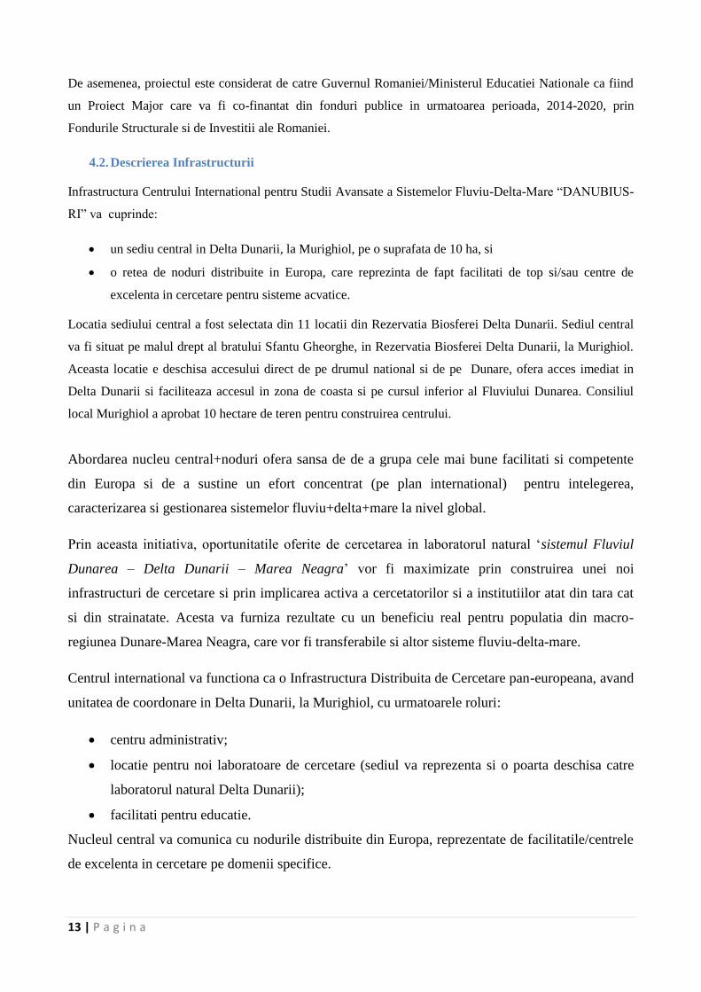
4.2. Descrierea Infrastructurii
Infrastructura Centrului International pentru Studii Avansate a Sistemelor Fluviu-Delta-Mare “DANUBIUS-
RI” va cuprinde:
un sediu central in Delta Dunarii, la Murighiol, pe o suprafata de 10 ha, si
o retea de noduri distribuite in Europa, care reprezinta de fapt facilitati de top si/sau centre de
excelenta in cercetare pentru sisteme acvatice.
Locatia sediului central a fost selectata din 11 locatii din Rezervatia Biosferei Delta Dunarii. Sediul central
va fi situat pe malul drept al bratului Sfantu Gheorghe, in Rezervatia Biosferei Delta Dunarii, la Murighiol.
Aceasta locatie e deschisa accesului direct de pe drumul national si de pe Dunare, ofera acces imediat in
Delta Dunarii si faciliteaza accesul in zona de coasta si pe cursul inferior al Fluviului Dunarea. Consiliul
local Murighiol a aprobat 10 hectare de teren pentru construirea centrului.
Abordarea nucleu central+noduri ofera sansa de de a grupa cele mai bune facilitati si competente
din Europa si de a sustine un efort concentrat (pe plan international) pentru intelegerea,
caracterizarea si gestionarea sistemelor fluviu+delta+mare la nivel global.
Prin aceasta initiativa, oportunitatile oferite de cercetarea in laboratorul natural ‘sistemul Fluviul
Dunarea – Delta Dunarii – Marea Neagra’ vor fi maximizate prin construirea unei noi
infrastructuri de cercetare si prin implicarea activa a cercetatorilor si a institutiilor atat din tara cat
si din strainatate. Acesta va furniza rezultate cu un beneficiu real pentru populatia din macro-
regiunea Dunare-Marea Neagra, care vor fi transferabile si altor sisteme fluviu-delta-mare.
Centrul international va functiona ca o Infrastructura Distribuita de Cercetare pan-europeana, avand
unitatea de coordonare in Delta Dunarii, la Murighiol, cu urmatoarele roluri:
centru administrativ;
locatie pentru noi laboratoare de cercetare (sediul va reprezenta si o poarta deschisa catre
laboratorul natural Delta Dunarii);
facilitati pentru educatie.
Nucleul central va comunica cu nodurile distribuite din Europa, reprezentate de facilitatile/centrele
de excelenta in cercetare pe domenii specifice.
14 | P a g i n a
Figura 1. Diagrama care prezinta conceptul centrului ‚DANUBIUS-RI’ (nucleu central + noduri)
Centrul va functiona ca o platforma de dialog permanent intre toate partile implicate pentru a
identifica si hotari asupra felului optim de folosire a resurselor naturale din zonele sensibile din
punct de vedere ecologic, fara a perturba functionarea sau structura ecosistemului.
Nodurile vor fi reprezentate de facilitati de top si centre de excelenta care au ca obiect de activitate
cercetarea proceselor naturale si/sau sociale, si/sau ofera acces la alte macrosisteme comparabile
(sau parti din acestea). Toate nodurile sunt conectate intre ele in mod direct si de asemenea prin/si
cu sediul centrului.
Structura centrului cu un nucleu fizic (sediu) in Delta Dunarii si noduri distribuite in Europa (atat in
cadrul cat si in afara Regiunii Dunarii) va oferi astfel sansa de a conecta cele mai bune expertize si
capacitati stiintifice din Europa, atat pentru macrosistemul Fluviu Dunarea – Delta Dunarii – Marea
Neagra cat si pentru alte macrosisteme similare la nivel global. Expertiza internationala adunata sub
umbrela acestui Centru, din stiintele mediului, vietii, Pamantului si cele socio-economice va oferi o
baza excelenta pentru dezvoltarea unei structuri care sa lucreze pentru dezvoltarea durabila a
sistemelor fluviu-delta-mare.
Crearea DANUBIUS-RI va cuprinde 3 faze, in perioada 2013 – 2020 (pe baza studiului de
fezabilitate si a materialelor care vor rezulta din proiectele FP7 DANCERS, si dupa intrarea pe lista
ESFRI, a proiectului Horizon 2020 care va fi dedicat DANUBIUS-RI pentru Faza Pregatitoare).
15 | P a g i n a
Faza 1 – 2014-2016
Prima faza consta in constructia infrastructurii de baza a nucleului de la Murighiol – „statia de
teren”, care va avea:
Facilitati de cazare si depozitare
Laboratoare
Echipament de birou.
In aceasta etapa va fi de asemenea necesara dezvoltarea legaturilor cu alte infrastructuri si facilitati
de cercetare, nationale si internationale, implicate in studii ale macrosistemelor fluviu-delta-mare.
La finalul acestei faze, centrul va fi deja o facilitate moderna, pan-europeana, pentru studii
complexe in teren a sistemului Dunarea – Delta Dunarii – Marea Neagra.
In aceasta faza se prevede constructia a ~70 % din totalul cladirilor planificate. Acestea sunt:
a. Cladiri destinate activitatilor de cercetare in sistemul fluviu – delta – mare:
Laboratoare pentru prepararea probelor colectate din teren;
Laboratoare pentru analiza probelor care trebuiesc lucrate imediat sau pentru probe care
nu pot fi transportate la alte laboratoare fara a fi deteriorate;
Facilitati de stocare pentru probe geologice si biologice;
Facilitati pentru stocarea pe termen lung a probelor de sedimente – o litoteca;
Ateliere pentru construirea si repararea echipamentului de teren
Facilitatii pentru pastrarea in bune conditii a echipamentelor de lucru.
b. Cladirea administrativa a centrului si cladire de birouri pentru cercetatori.
c. Cladiri care sa contina sali de conferinte, sali pentru intalniri/cursuri, biblioteca, centru IT
(ex. un centru de „cloud computing”), etc.;
d. Cladiri pentru cazarea
cercetatorilor,
personalului tehnic
personalului adimnistrativ,
studentilor si
vizitatorilor.
Alti pasi importanti de urmat, prevazuti in Faza 1 a constructiei includ:
16 | P a g i n a
inzestrarea centrului cu echipament pentru probare si observatii in situ, inclusiv echipament
automat si echipament pentru monitorizare pe termen lung care va fi amplasat in apa (brate,
lacuri, canale, etc.).
Furnizarea si instalarea de echipament stiintific in laboratoare pentru prepararea primara a
probelor si pentru analize imediate.
Echiparea cladirilor administrative si de birouri si a celor pentru conferinte, centru de calcul
si cazare;
Furnizare de facilitati tehnice si logistice pentru centru, care sa corespunda celor mai noi
standarde ale strategiilor de management ecologic pentru:
Alimentare cu apa,
Alimentare cu energie electrica,
Tratarea apei reziduale/uzate;
Debarcader pentru vasele si barcile de cercetare ale Centrului.
Faza 2 – 2016-2018
A doua faza a constructiei presupune furnizarea, instalarea si testarea echipamentelor de inalta
tehnologie, specializate, care vor forma o infrastructura europeana moderna de prim nivel la scara
globala, dedicata studiilor inter si multi-disciplinare a factorilor complecsi care controleaza starea
mediului si evolutia sistemulelor fluviu – delta – mare.
Lista detaliata a laboratoarelor specializate, de inalta tehnologie, facilitati/dispozitive/echipamente
de modelare fizica, facilitati de tip mezocosm, cat si echipamentul specializat pentru aceste
laboratoare, va rezulta din Proiectul de Faza Pregatitoare a DANUBIUS-RI dupa acceptarea pe lista
ESFRI.
Faza 3 – 2018-2020
Cea de a treia faza a constructiei va consta in dezvoltarea infrastructurii, in conformitate cu nevoile
identificate in viitoarea Faza Pregatitoare (si/sau viitoare alte categorii de proiecte – cu parteneri
internationali) si acestea for fi reprezentate de facilitati si capacitati de varf la nivel global, dar si
de nave de cercetare pentru studiul fluviului, deltei si marii:
O nava de cercetare de mari dimensiuni, complet echipata, multifunctionala pentru mare
(aprox. 2,000 – 2,500 t) si
O nava de cercetare de mici dimensiuni pentru fluviu, delta si zona costiera.
17 | P a g i n a
Nava maritima va fi parte a flotei de cercetare europene, urmand sa devina nava de serviciu a
Uniunii Europene pentru cercetarile din Marea Neagra.
Educatia/programul de strategie si infrastructura lui specifica va fi dezvoltata prin colaborari cu
universitati, unitati de cercetare – dezvoltare, alte proiecte ESFRI, infrastructuri europene si
regionale, precum si cu alte institutii care vor lua parte la activitatile Centrului International
Dunarea pentru Studii Avansate in Sistemele Fluviu – Delta – Mare.
4.3. Descrierea agendei stiintifice
Noua Infrastructura de Cercetare distribuita va fi dedicata studierii sistemelor fluviu - delta - mare, si isi
propune sa reuneasca echipe trans si interdisciplinare(din toate domeniile) de cercetatori, cu experienta
necesara pentru a rezolva problemele legate de sistemele rau-delta-mare. Aceste sisteme complexe si
dinamice trebuie să fie mult mai bine cunoscute, caracterizate si comunicate, dificultatile de monitorizare si
managementul acestor sisteme (la scara întregului bazin si in timp real) trebuie rezolvate, trebuie sa fie
dezvoltat un management integrat si flexibil in scopul de a evalua si analiza raurile, delta, litoralul si marea
aflata sub influenta fluviului ca pe o singură entitate.
Din punct de vedere stiintific, este necesara o abordare profunda a problemelor specifice si a intelegerii unor
aspecte legate de sistemele fluviu-delta-mare, cu toate ca la nivel european exista mai multe organizatii sau
initiative active in domeniul specific stiintelelor de cercetare multi-disciplinara cu privire la rauri, delte si
mari (doar segmente ale sistemelor integrate fluviu-delta-mare). DANUBIUS-RI va oferi o perspectivă
integratoare asupra sistemului fluviu- delta-mare, fiind o platformă unică si transdisciplinara în domeniu,
care va integra cunostintele existente din diferite discipline, precum cele din stiintele Pământului, ecologie,
stiintele vietii si stiintele socio-economice. DANUBIUS-RI va facilita si coordona activitati si proiecte de
cercetare si va oferi o infrastructura pentru a implementa si mentine puncte de monitorizare in intregul
sistem al bazinului hidrografic pana spre zona de mare adanca. De asemenea, centrul va asigura calitatea
datelor colectate, stocarea si diseminarea acestora.
Pentru a raspunde la diverse probleme legate de managementul integrat si eficient al sistemelor rau-
delta/estuar-mare, o serie de provocari stiintifice majore la nivel global trebuie sa fie abordate, cum ar fi:
- intelegerea genezei si evolutiei naturale a macrosistemelor Fluviu -Delta-Mare;
- cuantificarea impactului schimbarilor antropice asupra sistemelor Fluviu–Delta-Mare;
- determinarea vulnerabilitatii si/sau a modificarilor suferite de catre sistemele Fluviu–Delta-Mare ca
urmare a schimbarilor climatice;
- caracterizarea ciclurilor biogeochimice in intregul macrosistem Fluviu/Rau-Delta-Mare;
18 | P a g i n a
- management integrat avansat cu privire la inundatii/secete catastrofale cu hazard potential asupra
intregului macrosistem Fluviu/Rau-Delta-Mare;
- investigarea consecintelor deteriorarii fizice a structurilor morfologice si a habitatului (ex.
canalizari, indiguiri, baraje) si determinarea masurilor pentru refacerea hidromorfologiei naturale;
- conservarea si refacerea biodiversitatii din macrosistemele Fluviu/Rau-Delta-Mare;
- imbunatatirea si protejarea bunurilor si serviciilor furnizate de macrosistemele Fluviu-Delta-Mare;
- dezvoltarea solutiilor de management pentru cadrul politic existent si de viitor (de exemplu
Directiva Cadru Apa a Comisiei Europene);
- acordarea de expertiza stiintifica pentru dezvoltarea, imbunatatirea si testare de politici si norme de
protectia mediului.
DANUBIUS-RI se va implica in programe majore de cercetare a macrosistemelor fluviu-delta-mare care vor
raspunde la aceste provocari stiintifice complexe. Capacitatile stiintifice de baza ale DANUBIUS-RI vor
cuprinde o piramida a cunoasterii pe care se va baza managementul eficient, integrat, al macrosistemului
fluviu-delta-mare.
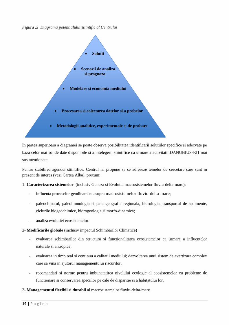
Potentialul stiintific al Centrului va include (vezi figura 2):
- o infrastructura adecvata de monitorizare, in care se va face colectarea de date si probe complexe si
in mod continuu;
- capacitatea de a dezvolta metodologii analitice si experimentale noi si avansate;
- dezvoltarea si aplicarea de modele noi si imbunatatite de mediu din macrosistemele rau-delta-mare,
care sa permita elaborarea de predictii;
- dezvoltarea si aplicarea unei abordari noi si performante in ceea ce priveste economia mediului
pentru a putea evalua legatura dintre societate si mediu;
- identificarea solutiilor de management pe baza prognozei detaliate si analizei de scenarii cu privire
la viitoarele schimbari de mediu.
19 | P a g i n a
Figura .2 Diagrama potentialului stiintific al Centrului
In partea superioara a diagramei se poate observa posibilitatea identificarii solutiilor specifice si adecvate pe
baza celor mai solide date disponibile si a intelegerii stiintifice ca urmare a activitatii DANUBIUS-RI1 mai
sus mentionate.
Pentru stabilirea agendei stiintifice, Centrul isi propune sa se adreseze temelor de cercetare care sunt in
prezent de interes (vezi Cartea Alba), precum:
1- Caracterizarea sistemelor (inclusiv Geneza si Evolutia macrosistemelor fluviu-delta-mare):
- influenta proceselor geodinamice asupra macrosistemelor fluviu-delta-mare;
- paleoclimatul, paleolimnologia si paleogeografia regionala, hidrologia, transportul de sedimente,
ciclurile biogeochimice, hidrogeologia si morfo-dinamica;
- analiza evolutiei ecosistemelor.
2- Modificarile globale (inclusiv impactul Schimbarilor Climatice)
- evaluarea schimbarilor din structura si functionalitatea ecosistemelor ca urmare a influentelor
naturale si antropice;
- evaluarea in timp real si continuu a calitatii mediului; dezvoltarea unui sistem de avertizare complex
care sa vina in ajutorul managementului riscurilor;
- recomandari si norme pentru imbunatatirea nivelului ecologic al ecosistemelor cu probleme de
functionare si conservarea speciilor pe cale de disparitie si a habitatului lor.
3- Managementul flexibil si durabil al macrosistemelor fluviu-delta-mare.
Procesarea si colectarea datelor si a probelor
Metodologii analitice, experimentale si de probare
Solutii
Scenarii de analiza si prognoza
Modelare si economia mediului
20 | P a g i n a
- metode si modele de dezvoltare durabila pe baza abordarii generale interdisciplinare;
- remedierea sistemului in contextul schimbarilor climatice (ca urmare a influentei climatice si
antropice);
- evaluarea schimbarilor sociale ale comunitatilor locale pentru dezvoltare durabila.
Centrul va dezvolta si utiliza alte metode fata de cele folosite pana acum in care, in mod traditional,
activitatile de cercetare asupra acestor sisteme erau efectuate separat pe diverse discipline. Aceste noi
metode privesc o abordare multi- si transdisciplinara, ca urmare a integrarii mai multor discipline apropiate
ca sa poata fi determinate solutii generale cu echipe de cercetatori din diverse ramuri.
Cateva exemple cu teme specifice de cercetare sunt detaliate in Tabelul 1 de mai jos.
Tabel 1. Exemple de topici de cercetare specifice propuse in conformitate cu necesitatile actuale
identificate in macrosistemul Dunare – Delta – Marea Neagra.
TOPICI DE CERCETARE SPECIFICE propuse de Centru
Caracterizarea sistemului
Originea si evolutia
sistemului Dunare –
Delta Dunarii – Marea
Neagra
- geneza fluviului si a bazinului;
- structura geologica;
- influenta dinamicii crustei pamantului asupra evolutiei fluviului;
- interactiunea dintre fluviu si mare (relatia dintre variatia nivelului marii si
conditiile din alte bazine de sedimentare);
- formarea deltei;
- evolutia depocentrelor, etc.
Procesele geodinamice - neotectonica;
- procesele de ridicare din zona de orogen si formarea si evolutia teraselor
fluviului;
- subsidenta si compactarea sedimentelor;
- corelarea cu evolutia sistemului.
Hidrologie,
hidrodinamica,
hidrogeologie si
sedimentologie
- variatia debitului lichid si solid din sistemul fluviu-delta-mare:
- ciclul de sedimentare (sursa – transport – depunere);
- bio- si geo-chimia apei si sedimentelor din intregul sistem;
- procesele hidrodinamice la interactiunea rau-mare si in zonele lacustre.
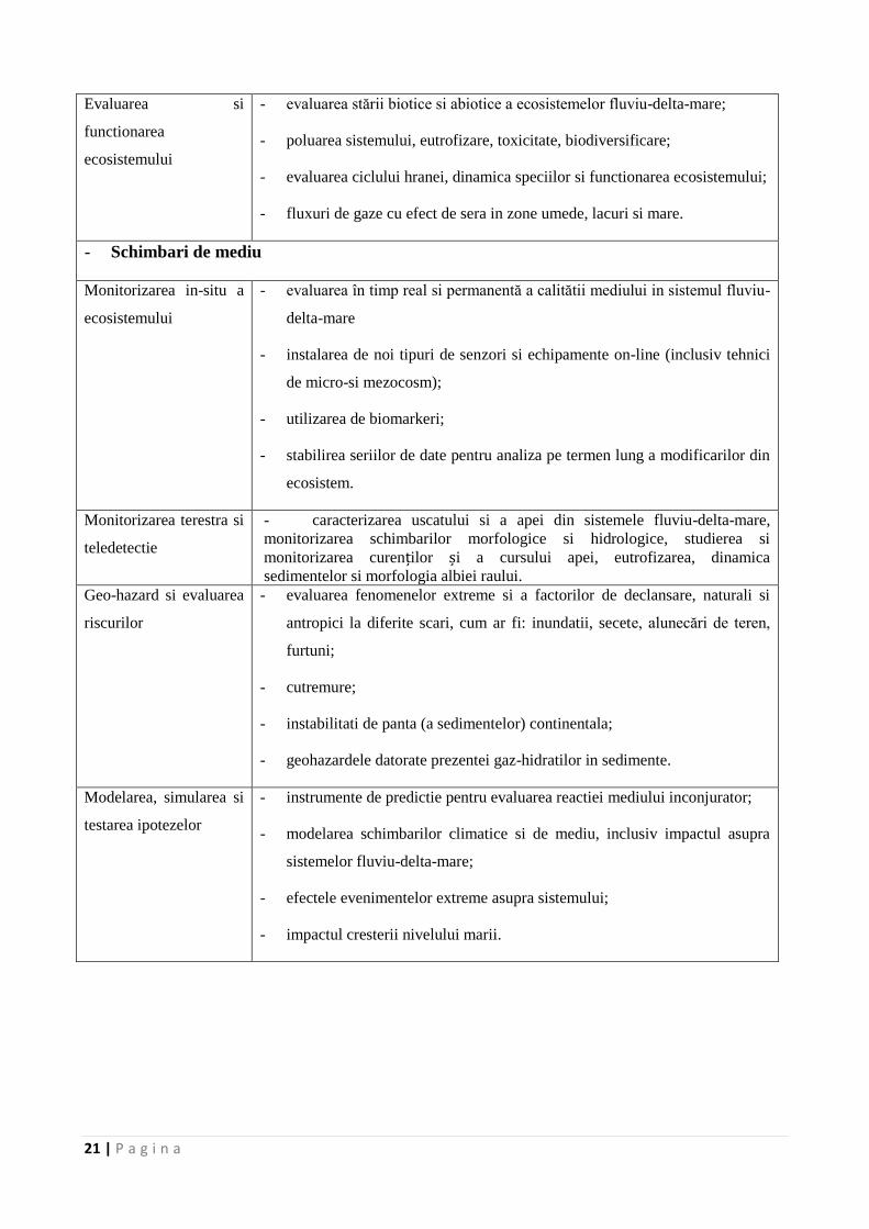
21 | P a g i n a
Evaluarea si
functionarea
ecosistemului
- evaluarea stării biotice si abiotice a ecosistemelor fluviu-delta-mare;
- poluarea sistemului, eutrofizare, toxicitate, biodiversificare;
- evaluarea ciclului hranei, dinamica speciilor si functionarea ecosistemului;
- fluxuri de gaze cu efect de sera in zone umede, lacuri si mare.
- Schimbari de mediu
Monitorizarea in-situ a
ecosistemului
- evaluarea în timp real si permanentă a calitătii mediului in sistemul fluviu-
delta-mare
- instalarea de noi tipuri de senzori si echipamente on-line (inclusiv tehnici
de micro-si mezocosm);
- utilizarea de biomarkeri;
- stabilirea seriilor de date pentru analiza pe termen lung a modificarilor din
ecosistem.
Monitorizarea terestra si
teledetectie
- caracterizarea uscatului si a apei din sistemele fluviu-delta-mare,
monitorizarea schimbarilor morfologice si hidrologice, studierea si
monitorizarea curenților și a cursului apei, eutrofizarea, dinamica
sedimentelor si morfologia albiei raului.
Geo-hazard si evaluarea
riscurilor
- evaluarea fenomenelor extreme si a factorilor de declansare, naturali si
antropici la diferite scari, cum ar fi: inundatii, secete, alunecări de teren,
furtuni;
- cutremure;
- instabilitati de panta (a sedimentelor) continentala;
- geohazardele datorate prezentei gaz-hidratilor in sedimente.
Modelarea, simularea si
testarea ipotezelor
- instrumente de predictie pentru evaluarea reactiei mediului inconjurator;
- modelarea schimbarilor climatice si de mediu, inclusiv impactul asupra
sistemelor fluviu-delta-mare;
- efectele evenimentelor extreme asupra sistemului;
- impactul cresterii nivelului marii.
22 | P a g i n a
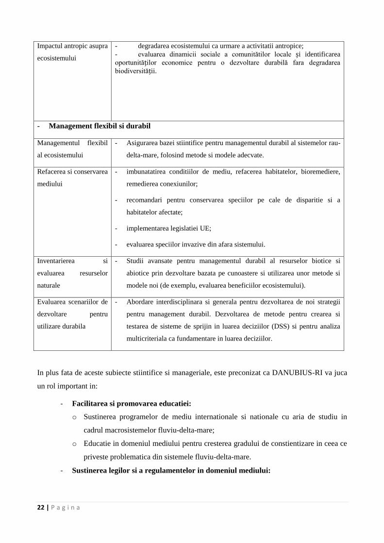
Impactul antropic asupra
ecosistemului
- degradarea ecosistemului ca urmare a activitatii antropice;
- evaluarea dinamicii sociale a comunitătilor locale și identificarea
oportunităților economice pentru o dezvoltare durabilă fara degradarea
biodiversității.
- Management flexibil si durabil
Managementul flexibil
al ecosistemului
- Asigurarea bazei stiintifice pentru managementul durabil al sistemelor rau-
delta-mare, folosind metode si modele adecvate.
Refacerea si conservarea
mediului
- imbunatatirea conditiilor de mediu, refacerea habitatelor, bioremediere,
remedierea conexiunilor;
- recomandari pentru conservarea speciilor pe cale de disparitie si a
habitatelor afectate;
- implementarea legislatiei UE;
- evaluarea speciilor invazive din afara sistemului.
Inventarierea si
evaluarea resurselor
naturale
- Studii avansate pentru managementul durabil al resurselor biotice si
abiotice prin dezvoltare bazata pe cunoastere si utilizarea unor metode si
modele noi (de exemplu, evaluarea beneficiilor ecosistemului).
Evaluarea scenariilor de
dezvoltare pentru
utilizare durabila
- Abordare interdisciplinara si generala pentru dezvoltarea de noi strategii
pentru management durabil. Dezvoltarea de metode pentru crearea si
testarea de sisteme de sprijin in luarea deciziilor (DSS) si pentru analiza
multicriteriala ca fundamentare in luarea deciziilor.
In plus fata de aceste subiecte stiintifice si manageriale, este preconizat ca DANUBIUS-RI va juca
un rol important in:
- Facilitarea si promovarea educatiei:
o Sustinerea programelor de mediu internationale si nationale cu aria de studiu in
cadrul macrosistemelor fluviu-delta-mare;
o Educatie in domeniul mediului pentru cresterea gradului de constientizare in ceea ce
priveste problematica din sistemele fluviu-delta-mare.
- Sustinerea legilor si a regulamentelor in domeniul mediului:
23 | P a g i n a
o Promovarea unei baze stiintifice in vederea imbunatatirii metodelor si a
instrumentelor de testare a cadrului legislativ specific, pentru mai buna
implementare a politicilor UE;
- Dezvoltarea de produse si tehnologii ecologice inovatoare:
o Concentrarea eforturilor in vederea valorificarii resurselor naturale in sistemele
fluviu-delta-mare in conformitate cu directiile dezvoltarii durabile.
- Dezvoltarea tehnologiilor inovatoare de cercetare-dezvoltare, a echipamentelor si
tehnicilor informatice si comunicare de date (IT&C):
o Metode inovative de monitorizare, masurare si modelare
o Noi metode de colectare a datelor, prelucrare, stocare si transfer, unde este
necesara dezvoltarea de noi capacitati tehnice si IT&C.
- Dezvoltarea unei meta-baze de date integrand literatura existenta in domeniu (si
date istorice) cat si date proprii din cadrul programelor ce se vor desfasura in cadrul
centrului, in colaborare cu partenerii existenti, in arealul Dunare-Marea Neagra.
4.4. Descrierea Managementului DANUBIUS-RI şi a procesului de Guvernanţă
Din perspectiva resurselor umane, centrul va cuprinde:
- O echipa de management, constand in
o la nivel strategic:
Presedinte – Director general;
Comitet de coordonare.
o la nivel operational:
sefi de departamente,
grupuri de lucru
echipe de sprijin.
o la nivel de sprijin:
consiliul consultativ international (incluzand cercetatori de valoare, precum si
reprezentanti ai altor posibili beneficiari / utilizatori)
Comitetul Director al centrului este organul executiv, care va lua deciziile DANUBIUS-RI. Aceasta va
conduce toate activitatile si va fi responsabil pentru strategia, implementarea si functionarea centrului.
Acesta va fi sprijinit de consiliul consultativ international.
Comitetul Director va cuprinde un presedinte, un vicepresedinte si 5 sau 7 membri (inclusiv directorul
general al DANUBIUS-RI). Membrii comitetului vor fi numiti pentru a asigura functionarea optima si
eficienta a centrului, pastrand in acelasi timp un echilibru rezonabil intre mediile stiintifice diferite, formare
si aptitudini.
- Gupurile si echipele de lucru
24 | P a g i n a
Echipele de lucru vor dezvolta activitatile stiintifice ale centrului, care sunt axate pe directiile principale
stabilite de catre Comitetul Director. Structura trebuie sa fie flexibila, cu o participare activa a personalului
tehnic, pentru a asigura intretinerea infrastructurii de cercetare. Fiecare grup de lucru va fi condus de un
cercetator reputat care ar trebui sa lucreze la un proiect bine definit, pentru o durata limitata.
In plus fata de cercetatori, grupurile de lucru vor fi sprijinite de:
o doctoranzi si post-doctoranzi care abordeaza probleme stiintifice de interes;
o personal stiintific la inceput de cariera, care conduc o activitate de cercetare
independenta, sub supravegherea unui cercetator cu renume;
o cercetatori care colaboreaza in zone specifice ale unui proiect pentru o perioada limitata
de timp.
La aceasta etapa, sunt avute in vedere doua sectiuni permanente ale centrului, si anume "activitatile IT" si
"educatie", pentru a asigura continuitatea.
Pozitia de Director General, precum si toate pozitiile din cadrul departamentelor de servicii vor fi
permanente, anuntate si recrutate in plan international. Noul management public va opera pentru a minimiza
birocratia si a creste motivatia si eficienta costurilor. Pozitiile de membri ai comitetului director si consiliul
consultativ international nu necesita o prezenta personala permanenta la sediul central.
- Echipele stiintifice si de cooperare
Ca infrastructura de cercetare de varf (dar si de educatie si inovare) pentru stiintele naturale si socio-
economice, DANUBIUS-RI va imbunatati transferul de cunostinte in acest domeniu prin colaborarea stransa
cu organizatiile de cercetare si educatie existente.
DANUBIUS-RI va avea printre parteneri o retea stransa de institutii pan-europene si universitati inca de la
inceput, astfel incat va beneficia din start de o expertiza deja disponibila. Acesta va coopera cu alte echipe de
cercetare pentru a aborda problemele semnificative in macrosistemele fluviu-delta-mare, cum ar fi reducerea
biodiversitatii, identificarea de solutii "ecologice" pentru dezvoltarea economica, si buna administrare a
resurselor limitate in acelasi timp cu cresterea populatiei.
Cercetatori de varf vor fi invitati sa formeze echipe de baza pentru a lucra in programele de cercetare ale
Centrului. Prezenta lor va atrage cercetatori tineri, precum si studenti cu studii universitare finalizate sau/si
in curs de finalizare care doresc sa castige experienta in aceste domenii atractive si pe tematici pline de
provocari stiintifice. Probele necesare pentru aceste studii vor fi prelevate, pastrate si analizate in cadrul
DANUBIUS-RI sau in laboratoarele altor organizatii de cercetare.
Platforma de educatie oferita de DANUBIUS-RI va oferi o valoare adaugata semnificativa prin crearea unui
forum pentru schimbul de cunostinte intre cercetatori si intre cercetatori si studenti. In acest sens, forumul va
promova proiecte de cooperare, in special intre echipe din estul si vestul Europei. Cursuri intensive, scoli de
vara, conferinte si seminarii vor fi mecanisme importante si valoroase de diseminare a cunostintelor. Mai
25 | P a g i n a
mult decat atat, Centrul va creste gradul de constientizare a valorii mediului natural si rolul sau in bunastarea
oamenilor, prin excursii ecologice si discutii destinate comunitatilor locale, profesori sau turisti.
Alte oportunitati semnificative sunt oferite prin legaturile cu Reteaua Universitatilor de la Marea Neagra.
Aceasta retea cuprinde peste 100 de institutii de invatamant superior din regiunea Marii Negre (incluzand
Turcia, Georgia, Armenia, Azerbaidjan, Ucraina, Moldova, Romania, Bulgaria, Grecia, Albania, Serbia) si
este coordonata de Universitatea "Ovidius" din Constanta, Romania.
DANUBIUS-RI va construi pe baza proiectelor, atat nationale cat si internationale, mai ales europene si in
principal Programele Cadru (HORIZON 2020). Acesta va initia in continuare si va participa la proiecte
internationale prin cooperarea cu alte organizatii de cercetare majore recunoscute in domeniile lor. Institute
romanesti de cercetare relevante si organizatii importante care se ocupa cu studierea si monitorizarea macro-
sistemului fluviului Dunare - Delta Dunarii - Marea Neagra vor fi gasi in DANUBIUS-RI o platforma
importanta de lucru si educatie.
De asemenea, DANUBIUS-RI va coopera in mod activ cu organizatiile nationale si internationale care sunt
desemnate cu gestionarea ecologica si durabila a elementelor specifice fluviului Dunarea - Delta Dunarii -
Marea Neagra, prin stabilirea de comun acord a planurilor pentru a rezolvare a unora dintre cele mai
importante provocari in macrosistemul Dunare - Marea Neagra.
- Bazinul Fluviului Dunărea
Grupul de Lucru Dunăre - Marea Neagră (DABLAS) a fost înfiinţat în anul 2001, cu scopul de a constitui o
platformă pentru cooperare în vederea protejării apelor şi ecosistemelor asociate din fluviul Dunărea şi din
Marea Neagră. Principalul său obiectiv a constat în dezvoltarea mecanismelor de finanţare pentru
implementarea proiectelor de investiţii în vederea reducerii gradului de poluare şi reabilitării ecosistemelor.
- Marea Neagră
Ţările cu ieşire la Marea Neagră (Bulgaria, Georgia, România, Federaţia Rusă, Turcia şi Ucraina) au semnat
în 1992 şi ratificat în 1994 Convenţia pentru Protecţia Mării Negre Împotriva Poluării (Convenţia de la
Bucureşti). În vederea implementării Convenţiei, a celor trei Protocoale ale sale (privind poluarea din surse
de pe uscat, privind poluarea prin deversare de la bordul navelor şi cel privind acţiunile concertate în caz de
accidente, precum scurgerile de petrol) şi a Planului Strategic de Acţiune pentru Reabilitarea şi Protecţia
Mării Negre Împotriva Poluării (1996, actualizat în 2002 şi 2009), în anul 2004 a fost înfiinţată Comisia
pentru Protecţia Mării Negre Împotriva Poluării (Comisia Mării Negre sau CMN), împreună cu Secretariatul
Permanent aferent, în calitate de organism interguvernamental de coordonare.
- Rezervaţia Biosferei Delta Dunării:
26 | P a g i n a
La momentul înfiinţării Rezervaţiei Biosferei Delta Dunării (RBDD), în anul 1990, Autoritatea pentru
Rezervaţia Biosferei Delta Dunării (ARBDD), o instituţie publică aflată sub coordonarea Ministerului
Mediului din România.
27 | P a g i n a
5. POTENTIALUL TEHNIC SI STIINTIFIC EXISTENT IN REGIUNEA DUNARII,
RELEVANT PENTRU MANAGEMENTUL INTEGRAT AL SISTEMELOR FLUVIU –
DELTA – MARE
5.1. Analiza infrastructurilor de cercetare existente in Regiunea Dunarii, relevante pentru
mangementul integrat al sistemelor fluviu – delta – mare
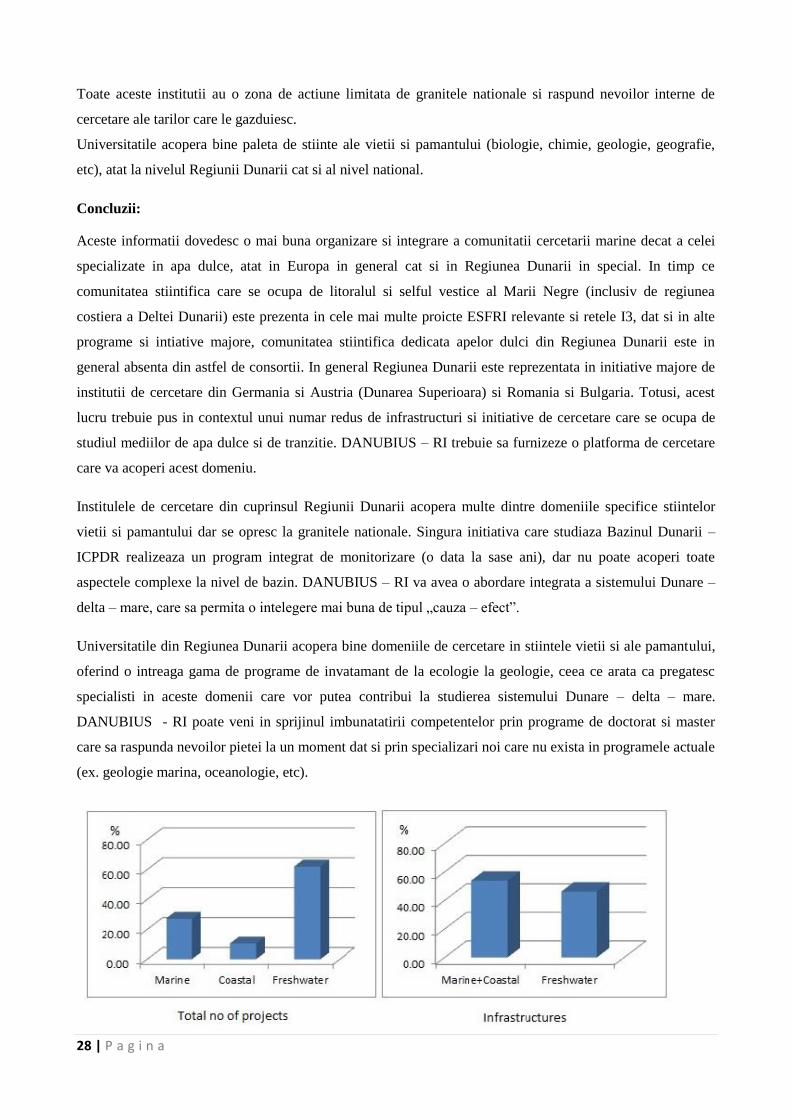
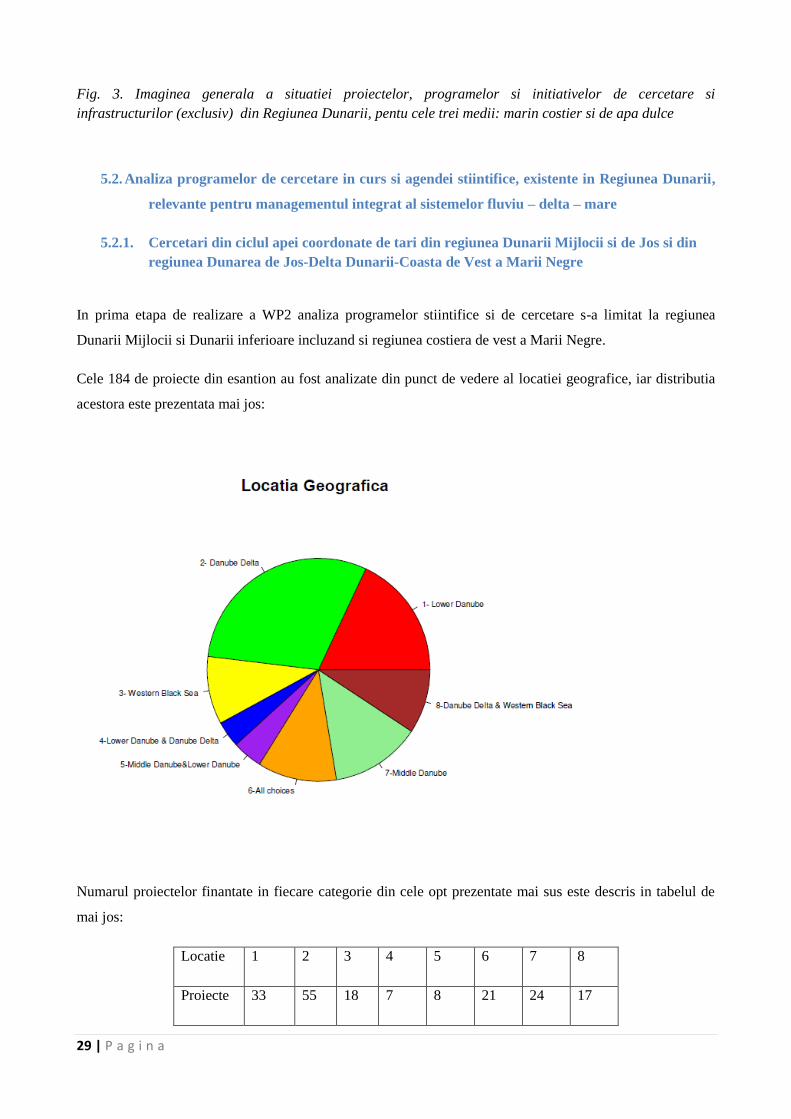
Infrastructurile majore, programele, proiectele si initiativele de cercetare din Regiunea Dunarii (cuprinzand
Germania, Austria, Slovacia, Ungaria, Serbia, Croatia, Bulgaria, Romania, Republica Moldova si Ucraina)
au fost analizate din punctul de vedere al activitatii lor specifice in diferitele parti ale sistemului Dunare –
Delta Dunarii – Marea Neagra. Astfel, trei categorii au fost stabilite (cele dedicate ‚Mediului Marin’,
‚Mediului Costier’ si ‚Mediului de Apa Dulce’). Peste 150 de infrastructuri, programe, proiecte si initiative
au fost identificate si in plus, o selectie a universitatilor, laboratoarelor si a altor institutii care isi desfasoara
activitatea in regiune a fost realizata (acestea au fost grupate in functie de tara in care se afla). Lista acestora,
impreuna cu cateva descrieri detaliate sunt prezentate in Anexa 7.1., cu mentiunea ca lista nu este
exhaustiva.
In ceea ce priveste lista proiectelor si initiativelor, analiza contine nu numai infrastructurile propriu-zise (ex.
Nave de cercetare), dar si proiecte locale si cele deja incheiate. Cele mai multe dintre acestea sunt localizate
in regiunea Dunarii Inferioare si Dunarii de Jos – Delta Dunarii – Marea Neagra. Din punct de vedere al
activitatii specifice in cadrul sistemului Dunare – Delta Dunarii – Marea Neagra, cele mai multe proiecte
(62%) sunt dedicate mediului de apa dulce, in timp ce numai 28% mediului marin. Zona de coasta reprezinta
obiectivul a numai 10% din totalul proiectelor de cercetare.
Daca sunt considerate numai infrastructurile si proiectele de infrastructura propriu-zise (ex. Proiecte ESFRI,
I3 si infrastructurile regionale) cea mai mare parte a lor (64%) este dedicata mediului marin si costier (18%
pentru zona costiera, daca este considerata zone de interactiune si nu este asociata marii). Dintre
infrastructurile analizate, numai 36% sunt dedicate Dunarii Superioare, Medii, Inferioare si Deltei Dunarii
(Fig 3).
Laboratoarele, universitatile si centrele de cercetare au fost analizate separat, fiind considerate entitati
individuale, care isi folosesc infrastructura in tara in care sunt gazduite. Au fost identificate 57 de
laboratoare, facultati si institute care au ca obiect de cercetare stiintele vietii si ale pamantului. Dintre acestea
numai 2 au ca obiectiv exclusiv Dunarea si Delta Dunarii – Institutul de cercetare Dunarea, al Academiei
Ungare de Stiinte si Institutul Delta Dunarii (Romania). Multe dintre acestea studiaza diferite aspecte ale
sistemului Dunare – Delta Dunarii – Marea Neagra, raspandite in cuprinsul Regiunii Dunarii – Centrul
pentru Schimbari Globale si Durabilitate, Universitatea BOKU, Austria; Institutul de Oceanologie ‘Fridtjov
Nansen’ al Academiei Bulgare de Stiinte; institutele Max Plank din Germania; institutele nationale
GeoEcoMar si „Grigore Antipa” din Romania; Universitatea din NoviSad, Serbia; etc.
%
28 | P a g i n a
Toate aceste institutii au o zona de actiune limitata de granitele nationale si raspund nevoilor interne de
cercetare ale tarilor care le gazduiesc.
Universitatile acopera bine paleta de stiinte ale vietii si pamantului (biologie, chimie, geologie, geografie,
etc), atat la nivelul Regiunii Dunarii cat si al nivel national.
Concluzii:
Aceste informatii dovedesc o mai buna organizare si integrare a comunitatii cercetarii marine decat a celei
specializate in apa dulce, atat in Europa in general cat si in Regiunea Dunarii in special. In timp ce
comunitatea stiintifica care se ocupa de litoralul si selful vestice al Marii Negre (inclusiv de regiunea
costiera a Deltei Dunarii) este prezenta in cele mai multe proicte ESFRI relevante si retele I3, dat si in alte
programe si intiative majore, comunitatea stiintifica dedicata apelor dulci din Regiunea Dunarii este in
general absenta din astfel de consortii. In general Regiunea Dunarii este reprezentata in initiative majore de
institutii de cercetare din Germania si Austria (Dunarea Superioara) si Romania si Bulgaria. Totusi, acest
lucru trebuie pus in contextul unui numar redus de infrastructuri si initiative de cercetare care se ocupa de
studiul mediilor de apa dulce si de tranzitie. DANUBIUS – RI trebuie sa furnizeze o platforma de cercetare
care va acoperi acest domeniu.
Institulele de cercetare din cuprinsul Regiunii Dunarii acopera multe dintre domeniile specifice stiintelor
vietii si pamantului dar se opresc la granitele nationale. Singura initiativa care studiaza Bazinul Dunarii –
ICPDR realizeaza un program integrat de monitorizare (o data la sase ani), dar nu poate acoperi toate
aspectele complexe la nivel de bazin. DANUBIUS – RI va avea o abordare integrata a sistemului Dunare –
delta – mare, care sa permita o intelegere mai buna de tipul „cauza – efect”.
Universitatile din Regiunea Dunarii acopera bine domeniile de cercetare in stiintele vietii si ale pamantului,
oferind o intreaga gama de programe de invatamant de la ecologie la geologie, ceea ce arata ca pregatesc
specialisti in aceste domenii care vor putea contribui la studierea sistemului Dunare – delta – mare.
DANUBIUS - RI poate veni in sprijinul imbunatatirii competentelor prin programe de doctorat si master
care sa raspunda nevoilor pietei la un moment dat si prin specializari noi care nu exista in programele actuale
(ex. geologie marina, oceanologie, etc).
29 | P a g i n a
Fig. 3. Imaginea generala a situatiei proiectelor, programelor si initiativelor de cercetare si
infrastructurilor (exclusiv) din Regiunea Dunarii, pentu cele trei medii: marin costier si de apa dulce
5.2. Analiza programelor de cercetare in curs si agendei stiintifice, existente in Regiunea Dunarii,
relevante pentru managementul integrat al sistemelor fluviu – delta – mare
5.2.1. Cercetari din ciclul apei coordonate de tari din regiunea Dunarii Mijlocii si de Jos si din
regiunea Dunarea de Jos-Delta Dunarii-Coasta de Vest a Marii Negre
In prima etapa de realizare a WP2 analiza programelor stiintifice si de cercetare s-a limitat la regiunea
Dunarii Mijlocii si Dunarii inferioare incluzand si regiunea costiera de vest a Marii Negre.
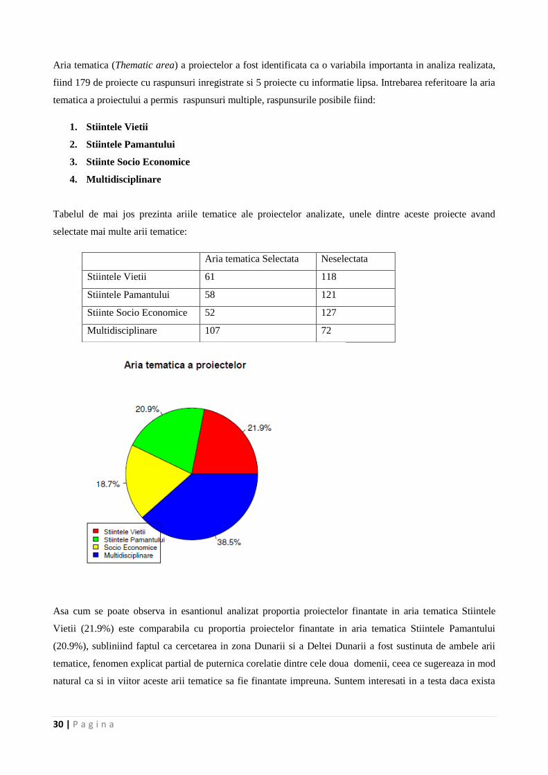
Cele 184 de proiecte din esantion au fost analizate din punct de vedere al locatiei geografice, iar distributia
acestora este prezentata mai jos:
Numarul proiectelor finantate in fiecare categorie din cele opt prezentate mai sus este descris in tabelul de
mai jos:
Locatie 1 2 3 4 5 6 7 8
Proiecte 33 55 18 7 8 21 24 17
30 | P a g i n a
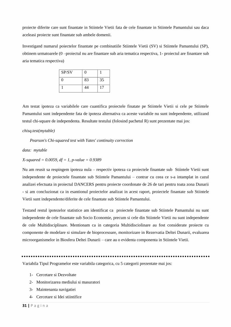
Aria tematica (Thematic area) a proiectelor a fost identificata ca o variabila importanta in analiza realizata,
fiind 179 de proiecte cu raspunsuri inregistrate si 5 proiecte cu informatie lipsa. Intrebarea referitoare la aria
tematica a proiectului a permis raspunsuri multiple, raspunsurile posibile fiind:
1. Stiintele Vietii
2. Stiintele Pamantului
3. Stiinte Socio Economice
4. Multidisciplinare
Tabelul de mai jos prezinta ariile tematice ale proiectelor analizate, unele dintre aceste proiecte avand
selectate mai multe arii tematice:
Aria tematica Selectata Neselectata
Stiintele Vietii 61 118
Stiintele Pamantului 58 121
Stiinte Socio Economice 52 127
Multidisciplinare 107 72
Asa cum se poate observa in esantionul analizat proportia proiectelor finantate in aria tematica Stiintele
Vietii (21.9%) este comparabila cu proportia proiectelor finantate in aria tematica Stiintele Pamantului
(20.9%), subliniind faptul ca cercetarea in zona Dunarii si a Deltei Dunarii a fost sustinuta de ambele arii
tematice, fenomen explicat partial de puternica corelatie dintre cele doua domenii, ceea ce sugereaza in mod
natural ca si in viitor aceste arii tematice sa fie finantate impreuna. Suntem interesati in a testa daca exista
31 | P a g i n a
proiecte diferite care sunt finantate in Stiintele Vietii fata de cele finantate in Stiintele Pamantului sau daca
aceleasi proiecte sunt finantate sub ambele domenii.
Investigand numarul poiectelor finantate pe combinatiile Stiintele Vietii (SV) si Stiintele Pamantului (SP),
obtinem urmatoarele (0 –proiectul nu are finantare sub aria tematica respectiva, 1- proiectul are finantare sub
aria tematica respectiva)
SP/SV 0 1
0 83 35
1 44 17
Am testat ipoteza ca variabilele care cuantifica proiectele finatate pe Stiintele Vietii si cele pe Stiintele
Pamantului sunt independente fata de ipoteza alternativa ca aceste variabile nu sunt independente, utilizand
testul chi-square de independenta. Resultate testului (folosind pachetul R) sunt prezentate mai jos:
chisq.test(mytable)
Pearson's Chi-squared test with Yates' continuity correction
data: mytable
X-squared = 0.0059, df = 1, p-value = 0.9389
Nu am reusit sa respingem ipoteza nula – respectiv ipoteza ca proiectele finantate sub Stiintele Vietii sunt
independente de proiectele finantate sub Stiintele Pamantului – contrar cu ceea ce s-a intamplat in cazul
analizei efectuata in proiectul DANCERS pentru proiecte coordonate de 26 de tari pentru toata zona Dunarii
- si am concluzionat ca in esantionul proiectelor analizat in acest raport, proiectele finantate sub Stiintele
Vietii sunt independente/diferite de cele finantate sub Stiintele Pamantului.
Testand restul ipotezelor statistice am identificat ca proiectele finantate sub Stiintele Pamantului nu sunt
independente de cele finantate sub Socio Economie, precum si cele din Stiintele Vietii nu sunt independente
de cele Multidisciplinare. Mentionam ca in categoria Multidisciolinare au fost considerate proiecte cu
componente de modelare si simulare de bioprocesoare, monitorizare in Rezervatia Deltei Dunarii, evaluarea
microorganismelor in Biosfera Deltei Dunarii – care au o evidenta componenta in Stiintele Vietii.
Variabila Tipul Programelor este variabila categorica, cu 5 categorii prezentate mai jos:
1- Cercetare si Dezvoltate
2- Monitorizarea mediului si masuratori
3- Maintenanta navigatiei
4- Cercetare si Idei stiintifice
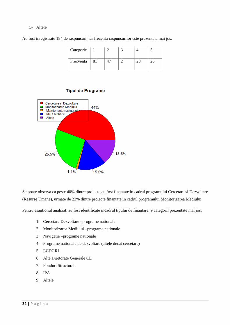
32 | P a g i n a
5- Altele
Au fost inregistrate 184 de raspunsuri, iar frecenta raspunsurilor este prezentata mai jos:
Categorie 1 2 3 4 5
Frecventa 81 47 2 28 25
Se poate observa ca peste 40% dintre proiecte au fost finantate in cadrul programului Cercetare si Dezvoltare
(Resurse Umane), urmate de 23% dintre proiecte finantate in cadrul programului Monitorizarea Mediului.
Pentru esantionul analizat, au fost identificate incadrul tipului de finantare, 9 categorii prezentate mai jos:
1. Cercetare Dezvoltare –programe nationale
2. Monitorizarea Mediului –programe nationale
3. Navigatie –programe nationale
4. Programe nationale de dezvoltare (altele decat cercetare)
5. ECDGRI
6. Alte Diretorate Generale CE
7. Fonduri Structurale
8. IPA
9. Altele
33 | P a g i n a
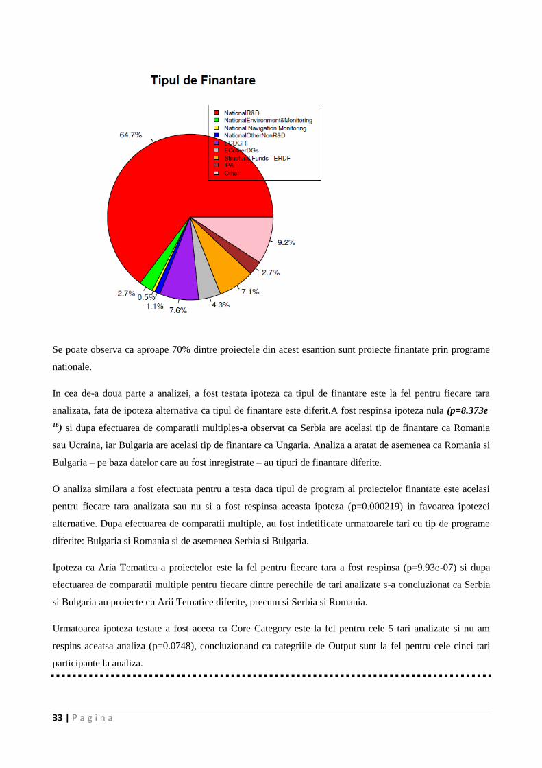
Se poate observa ca aproape 70% dintre proiectele din acest esantion sunt proiecte finantate prin programe
nationale.
In cea de-a doua parte a analizei, a fost testata ipoteza ca tipul de finantare este la fel pentru fiecare tara
analizata, fata de ipoteza alternativa ca tipul de finantare este diferit.A fost respinsa ipoteza nula (p=8.373e-
16) si dupa efectuarea de comparatii multiples-a observat ca Serbia are acelasi tip de finantare ca Romania
sau Ucraina, iar Bulgaria are acelasi tip de finantare ca Ungaria. Analiza a aratat de asemenea ca Romania si
Bulgaria – pe baza datelor care au fost inregistrate – au tipuri de finantare diferite.
O analiza similara a fost efectuata pentru a testa daca tipul de program al proiectelor finantate este acelasi
pentru fiecare tara analizata sau nu si a fost respinsa aceasta ipoteza (p=0.000219) in favoarea ipotezei
alternative. Dupa efectuarea de comparatii multiple, au fost indetificate urmatoarele tari cu tip de programe
diferite: Bulgaria si Romania si de asemenea Serbia si Bulgaria.
Ipoteza ca Aria Tematica a proiectelor este la fel pentru fiecare tara a fost respinsa (p=9.93e-07) si dupa
efectuarea de comparatii multiple pentru fiecare dintre perechile de tari analizate s-a concluzionat ca Serbia
si Bulgaria au proiecte cu Arii Tematice diferite, precum si Serbia si Romania.
Urmatoarea ipoteza testate a fost aceea ca Core Category este la fel pentru cele 5 tari analizate si nu am
respins aceatsa analiza (p=0.0748), concluzionand ca categriile de Output sunt la fel pentru cele cinci tari
participante la analiza.
34 | P a g i n a
Ultimele ipoteze au analizat daca numarul mediu de publicatii in reviste ISI, BDI, NRJ este egal pentru
fiecare dintre tarile analizate si nu a fost respinsa aceasta ipoteza. De asemena nu a fost respinsa ipoteza ca
numarul mediu de studenti doctoranzi sau masteranzi este acelasi pentru fiecare dintre tarile analizate, fata
de alternativa ca cel putin una din tari are un numar mediu de studenti diferit.
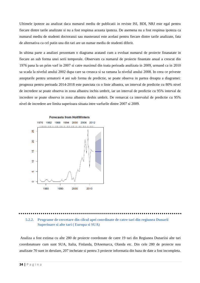
In ultima parte a analizei prezentam o diagrama aratand cum a evoluat numarul de proiecte finanatate in
fiecare an sub forma unei serii temporale. Observam ca numarul de proiecte finantate anual a crescut din
1976 pana la un prim varf in 2007 si catre maximul din toata perioada analizata in 2009, urmand ca in 2010
sa scada la nivelul anului 2002 dupa care sa creasca si sa ramana la nivelul anului 2008. In ceea ce priveste
asteptarile pentru urmatorii 4 ani sub forma de predictie, se poate observa in partea dreapta a diagramei:
prognoza pentru perioada 2014-2018 este punctata cu o linie albastra, un interval de predictie cu 80% nivel
de incredere se poate observa in zona albastru inchis umbrit, iar un interval de predictie cu 95% interval de
incredere se poate observa in zona albastru deshis umbrit. De remarcat ca intervalul de predictie cu 95%
nivel de incredere are limita superioara situata intre varfurile dintre 2007 si 2009.
5.2.2. Programe de cercetare din cilcul apei coordinate de catre tari din regiunea Dunarii
Superioare si alte tari ( Europa si SUA)
Analiza a fost extinsa cu alte 280 de proiecte coordonate de catre 19 tari din Regiunea Dunariisi alte tari
coordonatoare cum sunt SUA, Italia, Finlanda, DAnemarca, Olanda etc. Din cele 280 de proiecte nou
analizate 70 sunt in derulare, 207 incheiate si pentru 3 proiecte informatia din baza de date a fost incompleta.

35 | P a g i n a
In figura de mai jos este prezentata o imagine de ansamblu asupra prouectelor in functie da tarile
coordonatoare.
Ca si in etapa anterioara, aria tematica a fost una dintre variabilele importante identificate, fiind
inregistrate patru raspunsuri: Stiintele Vietii (SV), Stiintele Pamantului (SP), Stiinte Socio-Economice
(SSE), Multidisciplinare (M).
36 | P a g i n a
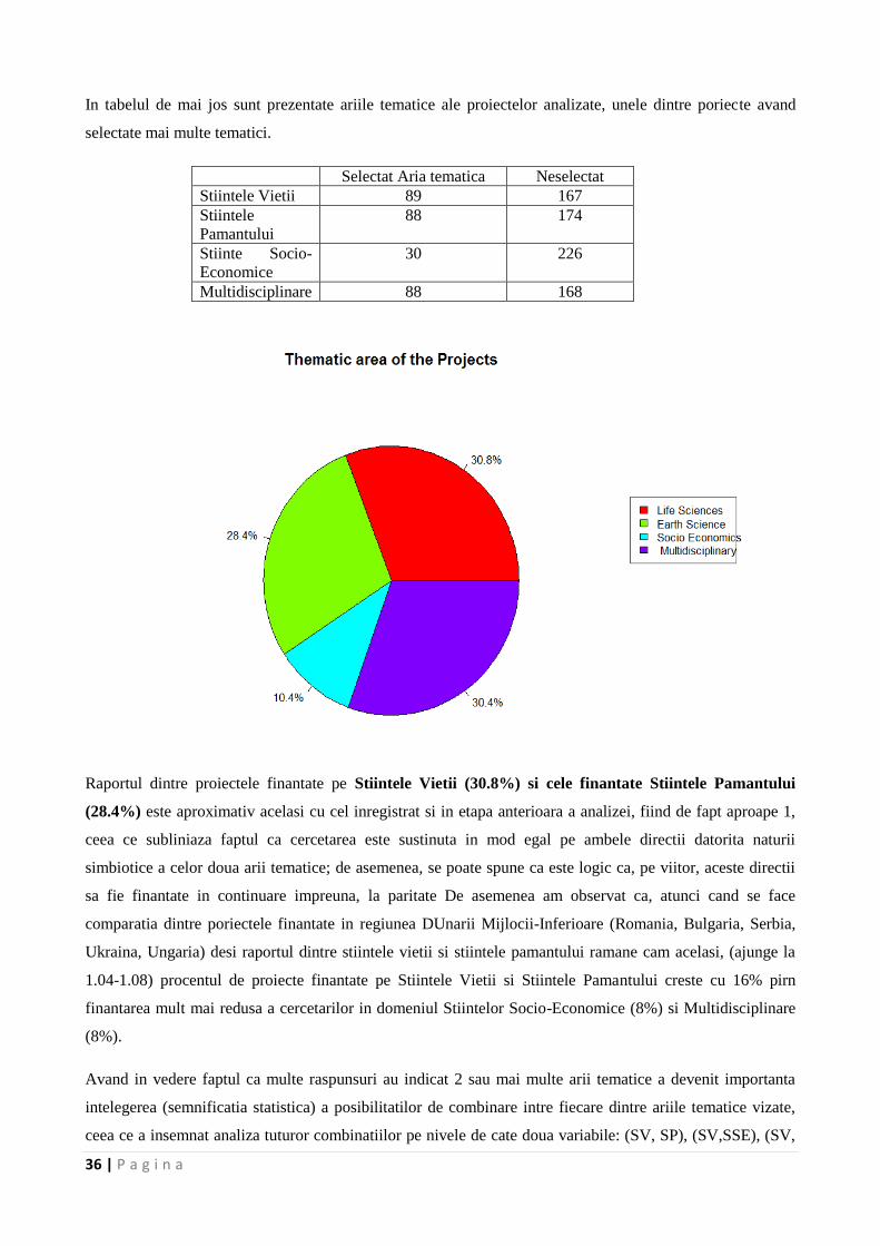
In tabelul de mai jos sunt prezentate ariile tematice ale proiectelor analizate, unele dintre poriecte avand
selectate mai multe tematici.
Selectat Aria tematica Neselectat
Stiintele Vietii 89 167
Stiintele
Pamantului
88 174
Stiinte Socio-
Economice
30 226
Multidisciplinare 88 168
Raportul dintre proiectele finantate pe Stiintele Vietii (30.8%) si cele finantate Stiintele Pamantului
(28.4%) este aproximativ acelasi cu cel inregistrat si in etapa anterioara a analizei, fiind de fapt aproape 1,
ceea ce subliniaza faptul ca cercetarea este sustinuta in mod egal pe ambele directii datorita naturii
simbiotice a celor doua arii tematice; de asemenea, se poate spune ca este logic ca, pe viitor, aceste directii
sa fie finantate in continuare impreuna, la paritate De asemenea am observat ca, atunci cand se face
comparatia dintre poriectele finantate in regiunea DUnarii Mijlocii-Inferioare (Romania, Bulgaria, Serbia,
Ukraina, Ungaria) desi raportul dintre stiintele vietii si stiintele pamantului ramane cam acelasi, (ajunge la
1.04-1.08) procentul de proiecte finantate pe Stiintele Vietii si Stiintele Pamantului creste cu 16% pirn
finantarea mult mai redusa a cercetarilor in domeniul Stiintelor Socio-Economice (8%) si Multidisciplinare
(8%).
Avand in vedere faptul ca multe raspunsuri au indicat 2 sau mai multe arii tematice a devenit importanta
intelegerea (semnificatia statistica) a posibilitatilor de combinare intre fiecare dintre ariile tematice vizate,
ceea ce a insemnat analiza tuturor combinatiilor pe nivele de cate doua variabile: (SV, SP), (SV,SSE), (SV,
37 | P a g i n a
M), (SP, SSE), (SP,M), (SEE, M). In tabelul de mai jos sunt prezentate rezultatele pentru Stiintele Vietii
versus Stiintele Pamantului.
Stiintele Vietii/Stiintele
Pamantului
0 1
0 83 35
1 44 17
Dupa cum s-a mentionat si anetorior cand analiza a fost limitata la Dunarea Mijlocie si Inferioara si vestul
Marii Negre, nu am reusit sa respingem ipoteza nula – respectiv ipoteza ca proiectele finantate sub Stiintele
Vietii sunt independente de proiectele finantate sub Stiintele Pamantului – si am concluzionat ca in
esantionul proiectelor analizat in acest raport, proiectele finantate sub Stiintele Vietii sunt
independente/diferite de cele finantate sub Stiintele Pamantului.
In analiza desfasurata in aceasta etapa de realizare a proiectului au fost identificate 6 categorii atunci cand s-
a considerat ca si variabila Tipul de program, si anume: In the current analysis under the Program Type we
have identified under only 6 categories that have been coded as follows for the analysis:
1. Cercetare-Resurse Umane & Educatie (People)
2. Cercetare – idei stiintifice si coperare stiintifica (Ideas)
3. Cercetare – dezvoltare si upgradare a infrastructurilor de cercetare (Capacities)
4. Monitorizarea mediului si masurari/observatii
5. Navigatie
6. Altele (SEE Transnational Cooperation Programme, Education, Policy, EESD Energy,
Environment and Sustainable Development (FP5)).
In cazul acestei variabile au fost inregistrate 274 de raspunsuri si 6 au avut informatii incomplete.
Repartizarea pe categorii este prezentata in tabelul de mai jos.
Categorie 1 2 3 4 5 6
Nr proiecte 3 7 80 103 32 49
Dupa cum se poate observa din diagrama de mai jos mai mult de 66% din numarul total de proiecte au fost
finantate pe ariile tematice 4- Monitorizarea mediului, masurari/observatii si respectiv 3 Cercetare –
dezvoltare si upgradare a infrastructurilor de cercetare (Capacitati).
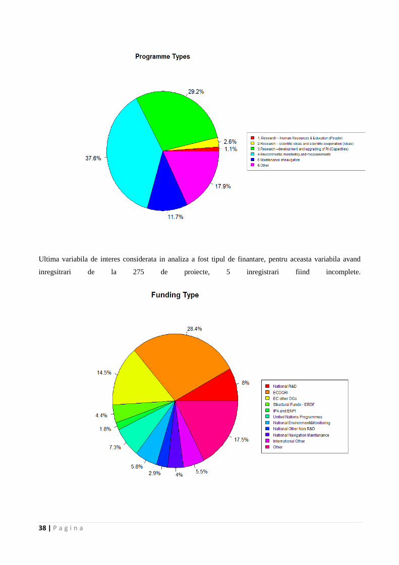
38 | P a g i n a
Ultima variabila de interes considerata in analiza a fost tipul de finantare, pentru aceasta variabila avand
inregsitrari de la 275 de proiecte, 5 inregistrari fiind incomplete.
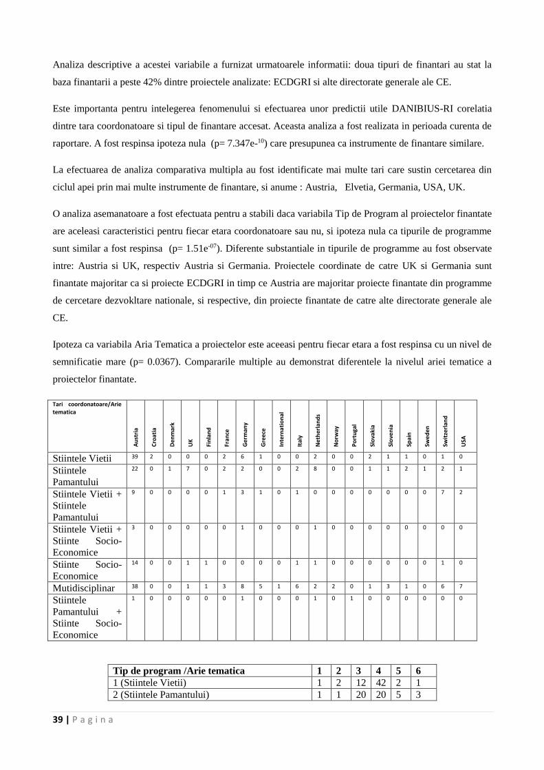
39 | P a g i n a
Analiza descriptive a acestei variabile a furnizat urmatoarele informatii: doua tipuri de finantari au stat la
baza finantarii a peste 42% dintre proiectele analizate: ECDGRI si alte directorate generale ale CE.
Este importanta pentru intelegerea fenomenului si efectuarea unor predictii utile DANIBIUS-RI corelatia
dintre tara coordonatoare si tipul de finantare accesat. Aceasta analiza a fost realizata in perioada curenta de
raportare. A fost respinsa ipoteza nula (p= 7.347e-10) care presupunea ca instrumente de finantare similare.
La efectuarea de analiza comparativa multipla au fost identificate mai multe tari care sustin cercetarea din
ciclul apei prin mai multe instrumente de finantare, si anume : Austria, Elvetia, Germania, USA, UK.
O analiza asemanatoare a fost efectuata pentru a stabili daca variabila Tip de Program al proiectelor finantate
are aceleasi caracteristici pentru fiecar etara coordonatoare sau nu, si ipoteza nula ca tipurile de programme
sunt similar a fost respinsa (p= 1.51e-07). Diferente substantiale in tipurile de programme au fost observate
intre: Austria si UK, respectiv Austria si Germania. Proiectele coordinate de catre UK si Germania sunt
finantate majoritar ca si proiecte ECDGRI in timp ce Austria are majoritar proiecte finantate din programme
de cercetare dezvokltare nationale, si respective, din proiecte finantate de catre alte directorate generale ale
CE.
Ipoteza ca variabila Aria Tematica a proiectelor este aceeasi pentru fiecar etara a fost respinsa cu un nivel de
semnificatie mare (p= 0.0367). Compararile multiple au demonstrat diferentele la nivelul ariei tematice a
proiectelor finantate.
Tari coordonatoare/Arie tematica
Au
stri
a
Cro
atia
Den
mar
k
UK
Fin
lan
d
Fran
ce
Ge
rman
y
Gre
ece
Inte
rna
tio
nal
Ital
y
Net
her
lan
ds
No
rway
Po
rtu
gal
Slo
vaki
a
Slo
ven
ia
Spai
n
Swe
den
Swit
zerl
and
USA
Stiintele Vietii 39 2 0 0 0 2 6 1 0 0 2 0 0 2 1 1 0 1 0
Stiintele
Pamantului
22 0 1 7 0 2 2 0 0 2 8 0 0 1 1 2 1 2 1
Stiintele Vietii +
Stiintele
Pamantului
9 0 0 0 0 1 3 1 0 1 0 0 0 0 0 0 0 7 2
Stiintele Vietii +
Stiinte Socio-
Economice
3 0 0 0 0 0 1 0 0 0 1 0 0 0 0 0 0 0 0
Stiinte Socio-
Economice
14 0 0 1 1 0 0 0 0 1 1 0 0 0 0 0 0 1 0
Mutidisciplinar 38 0 0 1 1 3 8 5 1 6 2 2 0 1 3 1 0 6 7
Stiintele
Pamantului +
Stiinte Socio-
Economice
1 0 0 0 0 0 1 0 0 0 1 0 1 0 0 0 0 0 0
Tip de program /Arie tematica 1 2 3 4 5 6
1 (Stiintele Vietii) 1 2 12 42 2 1
2 (Stiintele Pamantului) 1 1 20 20 5 3
40 | P a g i n a
3 (Stiintele Vietii + Stiintele Pamantului) 1 0 9 9 3 2
4 (Stiintele Vietii + Stiinte Socio-Economice) 0 0 2 1 1 1
5 (Stiinte Socio-Economice) 0 0 5 3 8 5
6 (Multidisciplinar) 0 3 20 19 10 36
7 (Stiintele Pamantului + Social Economics) 0 0 1 2 1 0
Ca si nivel de impact se poate spune ca s-a observant in urma analizei ca 42 de proiecte apartinand
Stiintelor Vietii ca si arie tematica au fost finantate prin fonduri structurale, ERDF, urmate de 36 de proiecte
incadrate ca si arie tematica la multidisciplinare, si finantate din categoria alte surse de finantare.
O imagine generala a cestui tip de clasificare este data in tabelul de mai jos.
Tip de program /Tip de finantare 1 2 3 4 5 6
1 0 1 2 10 4 5
2 1 1 70 3 0 0
3 1 1 4 18 4 11
4 0 1 0 4 3 4
5 0 0 0 2 1 2
6 0 1 0 8 3 8
7 0 0 0 15 1 0
8 0 0 0 4 0 3
9 0 0 0 3 8 0
10 1 0 4 6 1 3
11 0 1 0 27 7 12
Circa 25% dintre proiectele analizate au fost finantate prin instrumentul de finantare ECDGRI, programul
Capacitati.
La nivel de rezultate produse de catre proiectele finantate, la nivel de impact stiintific side formare a resursei
umane, adica traduse in numar de articole ISI, BDI sau NRJ si, respectiv, numar de masteranzi/doctori care
au fost formati si au intrat pe piata locurilor de munca.
Datele privind numarul de articole ISI au condus la concluzia ca UK, Germania si Olanda au coordonat
proiecte care au generat un numar de articole ISI semnificativ mai ridicat decat celelalte tari incluse in
studiu. Acelasi concluzii au rezultat si in ceea ce priveste numarul de masteranzi si doctoranzi.
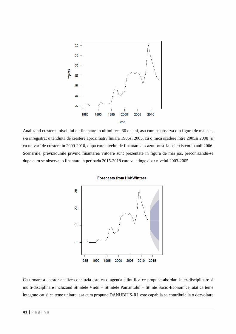
41 | P a g i n a
Analizand cresterea nivelului de finantare in ultimii cca 30 de ani, asa cum se observa din figura de mai sus,
s-a inregistrat o tendinta de crestere aprozimativ liniara 1985si 2005, cu o mica scadere intre 2005si 2008 si
cu un varf de crestere in 2009-2010, dupa care nivelul de finantare a scazut brusc la cel existent in anii 2006.
Scenariile, previziounile privind finantarea viitoare sunt prezentate in figura de mai jos, preconizandu-se
dupa cum se observa, o finantare in perioada 2015-2018 care va atinge doar nivelul 2003-2005
Ca urmare a acestor analize concluzia este ca o agenda stiintifica ce propune abordari inter-disciplinare si
multi-disciplinare incluzand Stiintele Vietii + Stiintele Pamantului + Stiinte Socio-Economice, atat ca teme
integrate cat si ca teme unitare, asa cum propune DANUBIUS-RI este capabila sa contribuie la o dezvoltare
42 | P a g i n a
unitara a strategiilor de cercetare sis a conduca la un impact pozitiv nu doar la nivelul comunitatii stiintifice
ci si la nivelul dezvoltarii regionale durabile.
5.3. Analiza programelor de dezvoltare a resursei umane specializate in mamagementul integrat al
sistemelor rau-delta-mare implementate in regiunea Dunarii
Problemele de mediu si asigurarea sustenabilitatii mediului in contextul modificarilor climatice majore, a
pierderii biodiversitatii si a altor factori cu impact negativ asupra mediului reprezinta un parametru de risc
pentru care trebuie gasite solutii si care fac obiectul de interes al tuturor actorilor importanti din regiunea
Dunarii. Resursa umana este capitalul cheie care contribuie major la dezvoltare, la progresul comunitatii si,
mai mult, la progresul economic bazat pe cunoastere.
Programele de dezvoltare a resursei umane specializate in managementul mediului (incluzand Stiintele
Vietii, Stiintele Pamantului si Stiinte Socio-Economice) sunt dedicate, in principal, specializarilor de master
si cateva dintre programele existente includ si programe doctorale; idea de specializare a resursei umane in
managementul integrat al sistemelor complexe rau-delta-mare este relative absenta, programele educationale
existente in universitati fiind mai mult concentrate pe probleme specifice/particulare.
Se poate observa un anumit grad de segregare bazate pe dispersie regional si de mediu, de exemplu sunt
specializari axate in general pe ape de suprafata si mediu acvatic respective pe mediu marin, dar sunt foarte
putine specializari pentru resursa umana calificata in problemele zonelor costiere si de tranzitie
Intr-un prim screening al programelor de dezvoltare a resursei umane implicate in cercetare-dezvoltare,
precum si a agendei stiintifice a organizatiilor active in regiunea Dunarii precum si a programelor
educationale imaginea rezultata este ne-unitara, evidentiindu-se legaturi lipsa intre partenerii potentiali, una
dintre principalele carente fiind cea generata de lipsa de cooperare eficienta in dezvoltarea de programme
care sa sustina dezvoltarea resursei umane specializate in managementul durabil al mediului si mentinerea
serviciilor ecosistemelor.
Se poate afirma ca in regiunea Dunarii exista o concentrare de resursa umana capabila sa contribuie active la
implementarea managementului integrat pentru sistemele rau-delta-mare dar capabilitatile existente sunt
imprastiate si, cumva polarizate, in mare parte polarizarea fiind orientata geo-economic. Regiunea Dunarii
superioare se caracterizeaza prin politici bine definite pentru resursa umana din cercetare, activitatile de
cercetare-dezvoltare-inovare desfasurandu-se intr-un mediu socio-economic cu strategii clare in care
interconectarea cercetare-programe educationale si chiar mediu de afaceri este functionala si eficienta. In
raport cu Dunarea superioara, celelalte zone care din regiunea Dunarii pot fi caracterizate prin centre
oarecum izolate, in care exista expertiza, atat la nivel de resursa umana cat si la nivel de infrastructura de
cercetare, dar care nu actioneaza coherent si concertat ceea ce conduce la o exploatare mai putin eficienta a
resurselor existente. Ca urmare trebuie subliniat in context ca provocarea curenta majora este transformarea
eficienta a structurilor existente intr-o retea functionala capabila sa aduca plus-valoare ca urmare a
concentrarii resurselor si a asigurarii masei critice de cunoastere care sa contribuie la o dezvoltare durabila a
43 | P a g i n a
regiunii. In acelasi timp trebuie subliniat ca, oarecum, aceeasi polarizare este evidenta si in legatura cu
topica adresata; daca centrele de cercetare din zona Dunarii inferioare se concentreaza mai mult pe topici
legate de interactiunea rau-mare si asupra impactului asupra Deltei Dunarii (incluzand zonele costiere,
marine), participarea la astfel de programe a centrelor de cercetare din zonele Dunarii superioare si mijlocii
este redusa.
Tot o imagine polarizata rezulta si la analiza numarului de cercetatori implicati in activitati legate de topici
de cercetare care au ca subiect managementul sistemelor rau-delta-mare. Zonele Dunarii superioare si
mijlocii au decenii de experienta in domeniul programelor educationale dedicate mediului, mentinerii
biodiversitatii, schimbarilor climatice si a subiectelor emergente din aceste topici.
Germania, de exemplu, are o abordare coerenta a agendei stiintifice si a cercetarii care, in final conduce la o
schema de finantare articulata care stimuleaza obtinerea de rezultate ce contribuie la rezolvarea unor
probleme specifice, functionalitatea sistemului fiind bazata pe o retea ce conecteaza eficient mediul
academic cu cel antreprenorial orientat catre tehnologii noi/avansate si cu industria, cu centre de inovare si
cu structuri care faciliteaza transferul de know-how si de inovare intre mediul academic si utilizatori
(stakeholders).
Sistemul German de educatie universitara este caracterizat de conexiuni eficiente intre educatia propriu-zisa
si cercetare, cu o componenta importanta de cercetare aplicata care functioneaza atat in sistem privat,
antreprenorial, cat si in sistem public. Un exemplu de eficienta in domeniul cercetarii aplicate il constituie
institutele Fraunhofer-Gesellschaft care constituie cea mai larga organizatie de cercetare aplicata din
Europa. Un alt exemplu de excelenta in cercetare este Societatea Max Planck care se concentreaza pe
cercetare fundamentala in domeniul stiintelor naturale, stiintelor vietii, stiintelor umaniste si sociale si care
are un rol activ in asigurarea componentei de complementaritate a cercetarii de excelenta in raport cu
cercetarea universitara. Componenta de cercetare academica este, de asemenea, puternica, asociatia
Helmholtz a centrelor germane de cercetare contributind activ la furnizarea de solutii pentru provocarile
majore sociale, stiintifice si industriale prin realizarea de cercetari de top pe directii strategice ce acopera un
domeniu larg de interes: aeronautica, spatiu si transporturi, stiintele pamantului si mediu, energie, sanatate,
tehnologii cheie si structura materialelor. Nivelul ridicat de interconexiune intre mediul academic, cercetarea
aplicata si industrie care exista in Germania este principalul factor care face din aceasta regiune unul dintre
furnizorii importanti de expertiza in dezvoltarea resursei umane specializate in managementul integrat al
sistemelor rau-delta-mare. Un alt potential furnizor de programe inalt-specializate, care sa contribuie la
formarea resursei umane, este Austria. (ex. Universitatea din Viena, BOKU, etc).
La celalalt pol se afla tarile din regiunea Dunarii mijlocii si inferioare care, pana la acest moment, au
dificultati si in furnizarea inventarului complet al proiectelor si activitatilor de training desfasurate care au ca
topica principala mediul, cercetarile in domeniile conexe si studiile socio-economice concentrate pe regiunea
Dunarii si problemele emergente, desi exista resursa umana specializata, dar care este fragmentar-distribuita.
44 | P a g i n a
In conformitate cu raportul Ministerului mediului din Republica Ceha functionalitatea educatiei pe probleme
de mediu este rezultatul eforturilor comune ale institutiilor de stat, profesionistilor, organizatiilor
guvernamentale si neguvernamentale, insa se recunoaste faptul ca efectele inregistrate pana acum sunt
locale, cel mult nationale, nicidecum regionale. Aceste universitati sunt implicate active in formarea de
resursa umana in domeniul mamagementului de mediu prin programme de master si doctorale, totusi supra-
specializarile postuniversitare la nivel de programme doctorale si postdoctorale nu sunt inca bine dezvoltate.
Totusi, cu exceptia Germaniei majoritatea dintre acestea au capabilitati si pot fi contributori importanti doar
pe componente ale sistemului care defineste managementul de mediu, fiind mai mult decat evident faptul ca
pana acum nu a existat o abordare orientata pe specializarea resursei umane in managementul integrat al
ciclului apei.
Furnizori importanti de expertiza in domeniul managementului mediului (Stiintele Pamantului si Stiintele
Vietii), pe componente, au fost identificati in Ungaria (Szeged si Universitatea din Budapesta), unele
universitati din Slovacia, Serbia si Romania. Exemple sunt Universitatea din Belgrad, Facultatea de Chimie,
Facultatea de Biologie, Facultatea de geografie si Faculattea de Geologie; Universiotatea idn NoviSad cu
Facultatea de Stiinte si Institutul de Genetica moleculara si Inginerie genetica, care au in dotare
infrastructura de cercetare de inalta tehnologie si au si expertiza in domenii stiintifice specifice, dar acre au
ca si dezavantaj major dispersarea strategiilor si implementarea necoordonata a programelor de cercetare-
dezvoltare chiar la nivel national, nemaivorbind despre nivelul regional. Un alt exemplu este Facultatea de
Stiinte ale naturii, Universitatea Comeniu Bratislava, care are program de master si de doctorat in doemnii
stiintifice care sunt parti ale abordarii multidisciplinare care este necesara pentru implementarea eficienta a
managementului de mediu. Dar, in acest caz, ca si in cazul Universitatilor din Romania, se poate spune ca
este aproape absenta abordarea integrata, globala a problemelor corelate cu managementul mediului,
siguranta ecosistemelor si asigurarea calitatii vietii.Universitatea din Bucuresti prin programele sale de
master si doctorat din cadrul Facultatilor de Biologie, Chimie, Geografie, Geologie si Geofizica, ca si
universitatea Babes-Bolyai University din Cluj sunt furnizori de resursa umana inalt specializata capabila sa
sustina dezvoltarea ulterioara a unor abordari pluri si multi-disciplinare necesare asigurarii implementarii
strategiilor priving managementul integrat al sistemelor rau-delta-mare.
Dupa cum este mentionat in raportul SUERD (axa prioritara 9) din Octombrie 2013 extrem de pentru
dezvoltarea durabila a regiunii este folosirea eficienta resursei umane actualmente prin dezvoltarea de
parghii de comunicare ce vor conduce la plus-valoare pe baza integrarii capabilitatilor, prin utilizarea mai
eficienta a instrumentelor deja existente, cum sunt programele Erasmus si Copernicus, si prin eficientizarea
structurilor de cooperare regionala.
Educatia si trainingul eficientizat, inovativ sunt bazele pentru a avea resursa umana specializata capabila sa
clarifice/sa rezolve provocarile generate de globalizare, variabilitatea demografica, dezvoltarea tehnologica
rapida si presiunea sociala crescanda datorata exercitiilor bugetare din bugetele publice. Schimbul de bune
practici intre diferite sisteme educationale si programe de training prin intermediu cooperarilor trans-
45 | P a g i n a
nationale, implementarii de programe comune si promovarii cercetarii in domeniul economiei educationale,
invatarii comune etc poate conduce la metodologii si politici realiste, bazate pe evidenta, si la strategii si
actiuni coerente care sa contribuie la dezvoltarea acestui tip de resursa umana specializata.
Resursele si knowhow-ul deja existente in regiunea Dunarii trebuie utilizate cu o coordonare mai buna,
exemple importante fiind: proiectele de infrasrtuctura care trebuie sa integreze module de training complexe;
programele trans-frontaliere (cum sunt cele Romania-Serbia, Romania-Bulgaria, Ungaria-Serbia, etc) si
programele de cooperare trans-nationale (cum sunt mecanismele SEE si Europa central) care au o
componenta de training ce, pana acum, nu a fost exploatata suficient.
O alta idee importanta este dezvoltarea de directii de “specializare a profesorilor/invatatorilor” in
managementul integrat al sistemelor rau-delta-mare de vreme ce dezvoltarea si implementarea
instrumentelor educationale in scolile primare, secundare si in la nivelul asociatiilro profesionale poate fi
cheia asigurarii dezvoltarii durabile a regiunii prin cresterea nivelului de constientizare publica.
Totusi, pentru o analiza obiectiva a situatiei actuale, trebuie mentionat faptul ca exista si sunt functionale si
unele retele intre universitati si institutii de cercetare din regiunea Dunarii. Cea mai importanta retea de
universitati este cea a Conferintei Rectorilor din regiunea Dunarii (DRC), un consortiu format din cele mai
importante universitati din regiune care include in acest moment 54 de parteneri. Scopul general al DRC
este imbunatatirea sistemelor de educatie, cresterea impactului educatiei superioare in dezvoltarea regional si
in cercetare din regiunea Dunarii si stabilirea de contacte bilaterale si multilaterale intre universitatile
memebre.
Un alt exemplu de retea regional este aceea a Asociatiei Europene a Universitatilor pentru Stiintele Vietii din
Europa Centrala si de Sud Est, ICA-CASEE care are in present 22 de membri. Aceasta asociatie, ICA-
CASEE a fost fondata in 2010 (de catre universitatea BOKU, Viena) si are ca obiective de baza:
Sustinerea inplementarii strategiei EU pentru regiunea Dunarii
Stimularea cercetarii, educatiei si dezvoltarii universitatilor din regiune
Dezvoltarea si implementarea de proiecte comune de cercetare, educatie precum si alte proiecte
regionale
Aceste obiective pot fi atinse, de exemplu, prin asigurarea unei curricula complementare, prin oferte
educationale comune, prin eforturi comune de dezvoltare structural si de resursa umana, prin transfer de
cunoastere si prin implementarea unor protocoale comune de evaluare si asigurare a calitatii, etc.
Pentru evitarea migratiei creierelor si pentru a asigura circulatia expertilor un punct critic il reprezinta
asiguararea unor scheme de finantare solide si sustinerea unor programme de schimb international de
student, profesori, oameni de stiinta. Aici DANUBIUS-RI poate juca rolul de integrator si coordinator al
46 | P a g i n a
resurselor existente, si de contributor major la realizarea unei strategii coerente privind politica de resursa
umana din regiune.
Concluzia care se structureaza in acest moment cu privire la programele de dezvoltare a resursei umane
specializate si rolul DANUBIUS-RI este ca DANUBIUS-RI poate fi un actor important in eficientizarea
comunicarii intre “partenerii sociali” mediul academic, utilizatorii industriali si comunitate prin furnizarea
de expertiza si de strategii regionale armonizate dezvoltatea pe baza unui nivel de cunoastere supra-
specializata.
5.4. Analiza potentialului tehnic si stiintific al infrastructurilor de cercetare din Regiunea Dunarii
si relevant pentru managementul integrat al sistemelor fluviu – delta – mare
Dupa analiza potentialului tehnic si stiintific al infrastructurilor de cercetare relevante pentru managementul
integrat al sistemului Dunare – Delta Dunarii – Marea Neagra, pot fi enuntate urmatoarele concluzii:
- In toata regiunea Dunarii nu exista o infrastructura pentru managementul integrat al sistemelor FDM
(i.e. Dunarea – Delta Dunarii – Marea Neagra).
- Diferite facilitati, laboratoare si alte IC exista in Regiunea Dunarii, dar sunt risipite, dedicate mai
ales scopurilor regionale/nationale; nivelul lor de interactiune/comunicare nu este optim;
- Exista o polarizatie in scop si distributie a IC – cele mai multe facilitati fiind concentrate in regiunea
Dunarii Superioare (Germania si Austria) si dedicate mai ales ecosistemelor de apa dulce, in timp ce
tarile din regiunea Dunarii Mijlocii (Ungaria, Croatia, Serbia) au de asemenea astfel de IC, dedicate
mai ales mediilor dulcicole. Al doilea mare pol care grupeaza facilitati de acest fel este totusi in
regiunea Dunarii de Jos – Delta Dunarii – Marea Neagra (Romania, Bulgaria, Moldova, Ucraina),
unde cel mai mare efort este concentrat in cercetarea marina (chiar daca exista facilitati pentru apa
dulce).
- Cele mai multe IC dedicate cercetarii apelor dulci, din Regiunea Dunarii, nu sunt implicate in
prezent in IC pan-europene majore (ESFRI, I3, infrastructuri regionale), nici nu sunt reprezentate in
structuri la JPI Water Challenges. Aceasta absenta este totusi corelata cu lipsa generala de
coordonare dintre IC de apa dulce din Europa.
- IC pentru zona costiera si marina din regiunea Dunare – Marea Neagra sunt integrate in cele mai
multe dintre eforturile pentru infrastructure pan-europene (EMSO – Romania, EURO-ARGO –
Bulgaria, EMBRC – Romania, I3 projects like EUROFLEETS, HYDRALAB, JERICO, etc-
ambele tari).
- Nu exista nici o iC dedicata intelegerii profunde a mediilor de tranzitie (ape dulci-mediul marin) –
dar acesta lipsa este identificata de asemena si la nivel european.
47 | P a g i n a
Totusi in ciuda lipsei de conectivitate, IC din Regiunea Dunarii acopera cele mai multe aspecte ale cercetarii
necesare unei abordari integrate a sistemelor FDM, asa cum este prezentat in anexele acestui raport.
Aceste facilitati, unele imbunatatite, alte nu, unele mai bine conectate decat altele la IC europene dedicate,
mai mult sau mai putin integrate intre ele, exista in numar mare.
De aceea noi consideram ca aceste acilitati reprezinta masa critica necesara construirii unei infrastructuri
distribuite, dedicata sistemelor FDM, concentrata pe Regiunea Dunarii. Totusi, aceste IC trebuie
imbunatatite si dezvoltate, mai bine conectate si corelate in vederea acestui scop.
Lipsa IC pan-europene in domeniul sistemelor FDM (si in cercetarea mediilor dulcicole in general), cat si in
studiul mediilor tranzitionale ar trebui considerata o oportuniatte majora pentru entitatile exitente in
Regiunea Dunarii, ca acestea sa devina nucleul unui astfel de efort.
5.5. Analiza principalelor puncte tari si puncte slabe ale infrastructurii de cercetare din Regiunea
Dunarii, relevante pentru managementul integrat al sistemelor fluviu – delta – mare
(infrastucturi de cercetare, agenda stiintifica si dezvoltarea resursei umane)
Punctele tari in ceea ce priveste resursele umane din Regiunea Dunarii sunt determinate de existenta unei
mase critice de resurse umane care pot asigura un nivel inalt de expertiza in diverse domenii care contribuie
la o abordare multi/interdisciplinara, pentru rezolvarea problemelor complexe legate de sisteme FDM.
Acelasi lucru poate fi spus si despre IC (vezi Cap. 5.4.). Teme de cercetare au fost dezvoltate in tot bazinul
Dunarii, chiar daca punctul lor focal a fost regional si axat pe probleme specifice fiecarui sector din sistemul
Dunare – Marea Neagra (tarile Dunarii Superioare si Mijlocii sunt mai mult implicate in cercetarea apelor
dulci, iar cele din Dunarea de Jos – Delta Dunarii – Marea Neagra in cercetarea mediilor de tranzitie si
marine).
Finantarile nationale pentru cercetare&dezvoltare au constituit principala sursa pemtru cercetarea stiintifica
din toate tarile dunarene, chiar daca rolul Comisiei Europene a fost in crestere in ultimele doua decenii. Cu
toate acestea, numarul proiectelor de cercetare si a surselor de finantare arata o diferenta neta intre Germani
si Austria (pe de o parte), fostele state comuniste ca Slovacia, Ungaria, Romania si Bulgaria, dar si statele
din fosta Iugoslavie (Croatia si serbia, tari afectate de razboi si embargouri economice pentru multi ani) si
Moldova &Ucraina, care au fost recent acceptate ca state sociate UE.
Trecutul isoric recent (perioada comunista si post-comunista) reprezinta una dintre principalele cauze ale
punctelor slabe: risipirea cercetarii in Regiunea Dunarii, dar si lipsa de comunicare. Etapa de reorganizare
este refectata in prezent de dezvoltarea a mai multor aspecte ale cercetarii (IC, agenda educationala i
stiintifica).
In Germania si Austria sistemul integreaza toate partile interesate (mediul academic, industrie si afaceri,
societate) si exista deja strategii adoptate care implica unitatile de educati superioara, IC, structuri de
cercetare, reprezentanti ai industriei si afacerilor, ai societatii, factori politici si decizionali, in timp ce in
48 | P a g i n a
celelalte tari dunarene (Slovacia, Croatia, Ungaria, Serbia, Romania, Bulgaria, Moldova si Ucraina),
resursele umane (dar si facilitatile in general) sunt risipite, concentrate pe chestiuni punctuale si sunt afectate
de lipsa unei comunicari adecvate dintre mediul academic/de cercetare&dezvoltare si celelalte parti,
reprezentanti din mediul de afaceri si industrie sau factori de decizie.
In consecinta, principalele puncte slabe sunt:
- Polarizarea inaltei specializari intre Dunarea Superioara si Dunarea Medie si de Jos. Specializari
dedicate cercetarii marine sunt mai ales in tari din regiunea Dunarii de Jos.
- Disperia spatiala
- Dispersia stratetgica
- Lipsa de coerenta, atat in dezvoltarea de resurse umane cat si in strategiile privind managementul
integrat al sistemelor FDM.
Educatia superioara si cercetarea stiintifica reprezinta cheia pentru dezvoltarea Regiunii Dunari, cu toate
aspectele durabilitatii. Programele strategice sunt cai probate si confirmate pentru sustinerea cu succes a
durabilitatii unei regiuni, crescand valoarea creata intr-o regiune si asigurand securitatea sociala. Strategiile
pentru specializari inteligente si cooperare transnationala trebuie implementate si, in ideea ca DANUBIUS-
RI va fi un promotor al solutiilor de top si un initiator capabil de a gasi noi cai pentru dezvolatre viitoare si
de a umple golurilor crearii de resurse umane, rolul sau sau va fi acela de furnizor al strategiilor de
dezvoltare pe baza rezultatelor cercetarii integrate si implementate de resurse umane inalt specializate
pentrua a face fata provocarii zilelor noastre ca macroregiune si la nivel global. Efectele sinergetice in si
intre universitatile din Regiunea Dunarii si organizatiile si institutele de cercetare trebuie intarite pentru a
mari sustinerea politica si economica.
Este important de inteles ca politicile dezvoltate in domeniul educatiei si cercetarii sunt coerente cu
aplicatiile lor in domeniul afaceri si industrie si ca cerintele economice sunt luate in considerare ca prioritati
ale educatiei si cercetarii. Unind fortele educatiei – cerectarii – economice, un avantaj competitiv strategic
va fi dezvoltat pentru structura care diferentiaza abordarea DANUBIUS-RI de altele similare, concentrandu-
se mai bine pe furnizarea de solutii complete si sanatoase pentru problemele sociale si economice, legate de
bunastare si mediul inconjurator, toate acestea luate impreuna si interconectate.
Analizand potentialul Regiunii Dunarii se contureaza clar necesitatea crearii si dezvoltarii de noi specializari
si facilitati in masura sa creeze competente pentru implementarea unei noi economii, bazate pe cunostere,
cercetare.
In acelasi timp, ar trebui mentionat ca DANUBIUS-RI va sustine activitatile educationale pentru a introduce
tinerii cercetatori in sisteme complexe, fiind atat integrator al expertizei deja existente cat si promotor a
strategiilor comune capabile sa sustina managementul integrat al sistemelor complexe FDM.
49 | P a g i n a
6. CONCLUZII SI RECOMANDARI
Regiunea Dunarii nu este bine conectata cu initiativele europene majore de infrastructuri de cercetare
(ESFRI, LTER, I3), dedicate domeniilor legate de apa dulce. In afara de Germania, Austria si Romania,
exista foarte putini parteneri (Bulgaria) sau nu exista deloc reprezentanti din Regiunea Dunarii in aceste
infrastructuri. Situatia generala este caracterizata de fragmentare si slaba comunicarea intre diferitele
infrastructuri care au legatura cu sistemul Dunare-Delta Dunarii-Marea Neagra, si care necesita imbunatatiri
mari. O alta discrepanta majora exista intre infrastructurile dedicate apelor dulci si cele costiere si marine.
Infrastrcucturile marine pan-europene majore sunt bine conectate cu NV Marii Negre, atat Romania cat si
Bulgaria fiind membri in aceste structuri ESFRI (Romania in EMSO si Bulgaria in EURO-ARGO) si
proiecte I3 (ambele in EUROFLEETS, Bulgaria in JERICO, Romania in HYDRALAB IV). Aceasta
dovedeste si o mai buna organizare a comunitatii de cercetare marina decat a celei care se ocupa de apa
dulce, nu numai in zona dar si in Europa in general. Nu exista in acest moment infrastructuri majore care
doresc sa lege fluviul de mediul de tranzitie apa dulce-sarata si costier ale sistemului. In acest fel,
DANUBIUS – RI ar acoperi un gol major in peisajul infrastructurilor din Regiunea Dunarii dar si din
Europa (vezi raportul fazei I).
Cu toate acestea, in toate tarile danubiene exista capacitate cu potential major de imbunatatire (asa cum a
fost aratat pana acum). Aceste capacitati trebuie insa intarite, integrate si facute sa colaboreze eficient in
acord cu o strategie coerenta. Chiar mai mult, aceste capacitati trebuie sa coopereze mai bine cu alte facilitati
din Europa, dupa o filozofie coerenta pentru intregul bazin al Dunarii. Din nou, DANUBIUS – RI ar trebui
sa raspunda acestor probleme, furnizand solutii si strategii.
Educatia reprezinta o alta problema critica. Necesitatea cresterii numarului de initiative care doresc
imbunatatirea calitatii educatiei in linie cu cererile pietei de munca, necesitatea crearii de oportunitati pentru
o mai buna calificare si generarea conditiilor de dezvoltare a cercetarii aplicate, avand in veder transferul de
cunoastere reprezinta factori-cheie de dezvoltare in Regiunea Dunarii.
Rolul DANUBIUS – RI este acela de a acoperi in mod eficient golul de comunicare intre ‘parti’ (mediul
academic, industrie, comunitate), acordand expertiza specializata si fiind furnizorul unor strategii armonizate
bazate pe cunoastere de nivel inalt.
Rezultate ale conferintelor si seminariilor
In Regiunea Dunarii, fragmentarea institutiilor de cercetare este si mai acuta. Cauzele sunt legate de aspecte
heterogene din institutii si proiecte. Colaborarea nu este nici ea optima, datorita abordarilor divergente in
tematica de cercetare si zona de interes.
50 | P a g i n a
Avand de a face cu diferite tari/institutii in diferite elemente ale sistemului (fluviu, delta, mare), fiecare isi
stabileste diferit directiile prioritare de dezvoltare si colaborare, fara sa analizeze in general, imaginea de
ansamblu.
La nivelul de institutii coordonatoare, acestea sunt dedicate marii (Comisia Marii Negre) sau fluviului
(ICPDR – Comisia Internationala pentru Protectia Fluviului Dunarea). Fiecare dintre ele are prioritati si
obiective divergente si diferite. O incercare anterioara (2000-2009) de a corela mai bine cercetarea de mediu
in zona Dunarii si a Marii Negre – DABLAS – a inceput cu success dar s-a incheiat datorita evolutiei anilor
2000. Strategia Europeana pentru Regiunea Dunarii (EUSDR) reprezinta o initiativa care integreaza
prioritatile din zona. De aceea, EUSDR a acordat statutul de Proiect Fanion in regiune pentru DANUBIUS –
RI, pentru modul in care acest proiect integreaza si armonizeaza prioritati si idei.
Un punct important este totusi intelegerea prioritatilor si intereselor fiecarei tari in relatie cu pozitia ei in
Regiunea Dunare – Marea Neagra, pentru ca aceasta explica partial diferentele, atat din punctul de vedere al
dezvoltarii economice cat si din punct de vedere al agendei stiintifice si prioritatilor (a se vedea preocuparile
Ungariei pentru apa pluviala).
Peste 450 de proiecte majore derulate sau in curs de derulare in ultimii 15 ani au fost identificate prin
Proiectul FP7 DANCERS. Aceasta demonstreaza ca zona are capacitatea de a trage fonduri, chiar daca in
mod fragmentar. De aceea consideram ca un proiect pan-european ESFRI, cu statutul legal de ERIC, va
facilita si va da valoare aspectelor financiare din zona si va contribui la sporirea interconectivitatii cu restul
Europei. DANUBIUS – RI va fi un punct de validare unic, din punct de vedere stiintific, mai ales in
programul Orizont 2020.
DANUBIUS – RI va integra institutii si tari din regiunea Dunarii si Marii Negre atat intre ele cat si cu restul
Europei, cu atat mai mult cu cat nodurile sale vor aduce excelenta in expertiza si cercetare din toata Europa.
Din punctul de vedere al comunitatii de afaceri, DANUBIUS – RI trebuie sa abordeze prioritati si obiective
traduse in teme simple si cuprinzatoare care pot atrage mediul privat in forme multiple de colaborare.
Comunitatea stiintifica implicata trebuie de asemenea sa inteleaga, sa clasifice si sa sintetizeze interesele
comunitatii de afaceri, constrangerile si prioritatile, pentru a putea furniza rezultatele asteptate.
O atentie speciala ar tebuie acordata aspectelor colaborative cu JPI (Joint Programming Initiatives), dintre
care JPI Water si JPI Oceans sunt de interes special pentru DANUBIUS – RI.
Aspecte colaborative
Oragnizatiile de cercetare analizate in panel folosesc infrastructuri cu acces deschis la date in proiectele
colaborative in care participa si pun la dispozitie propria infrastructura in cadrul proiectelor pan-europene.
Facilitatile de cercetare sunt disponibile direct in cadrul organizatiei (laboratoare cu echipament stiintific
performant, statii de masura in situ si la distanta) sau pot fi accesate in colaborare cu alte institutii partenere
(vapoare de cercetare, vehicule subacvatice teleghidate si submarine, drone, instalatii de teste hidraulice si
hidrodinamice, baze de date).
51 | P a g i n a
Concluzii:
- Exista numeroase facilitati de cercetare si institutii in Regiunea Dunarii, care pot fi incluse in
DANUBIUS – RI.
- O organizatie de cercetare poate fi parte (ca nod, satelit, partener cu sau fara drept de vot) la una sau
mai multe initiative si proiecte de cercetare, deschizand astfel o perspectiva lui DANUBIUS – RI, de
a include astfel de infrastructuri ca sateliti sau viitoare noduri.
- In Regiunea Dunarii exista multe organizatii de cercetare care nu sunt incluse in infrastructure
distribuiti, si reprezinta potentiali participanti in proiecte viitoare de infrastructuri distribuite.
DANUBIUS – RI ar putea include unele dintre aceste institutii ca noduri, sub coordonarea centrului,
atata timp cat vor fi identificate beneficiul comun in domeniul de cercetare si sustenabilitatea
nodului.
Rezultatele agendei stiintifice:
Concluzii:
- Agendele institutiilor de cercetare si proiectelor din Regiunea Dunarii acopera aspecte legate de
managementul ciclului apei, geostiinte, stiintele mediului si ale vietii.
- Nu toate agendele acopera ciclul apei, asa cum sunt definite in Cartea Alba a DANUBIUS – RI, dar
aceasta poate fi cobnsiderata o complementaritate.
- Exista maniere diferite de a prezenta agenda unei institutii:
o Dupa obiectiv
o Dupa rezultate
o Dupa metode
o Dupa sistemul sau obiectul de studiu
o Dupa colaborari
- In ceea ce priveste aspectele colaborative si de conectivitate pentru fiecare organizatie, agenda
stiintifica este dezvoltata in relatie directa cu numarul proiectelor de colaborare trecute si actuale.
Resurse umane
Resursa umana intr-un proiect la scara larga, pan-europeana, reprezinta totatlitatea resurselor alocate, care se
ocupa de cercetare, colaborare, educatie si managemntul unui astfel de proiect.
Concluzii
- Numarul total de persoane da o idee despre dimensiunile organizatiei;
52 | P a g i n a
- Personalul fiecarei organizatii este in relatie directa cu agenda stiintifica si proiectele in care aceasta
este implicata;
- Personalul DANUBIUS-RI va fi planificat in acord cu propriile nevoi de cercetare si perspectiva de
dezvoltare.
- Managementul DANUBIUS-RI va cauta complementaritate in termeni de educatie si abilitati in
comunitatea de cercetare din Europa;
- Criteriile folosite pentru selectia nodurilor vor include de asemenea si resursa umana si abilitatile si
inzestrarile fiecarei organizatii care candideaza;
- Relatia de colaborare a DANUBIUS-RI va fi definita pe baza unei analize detaliate a potentialului
resurselor umane a organizatiei corespunzatoare.
Provocari si probleme nerezolvate
Principalele provocari identificate sunt legate mai ales de aspecte financiare si instutitutionale si de
dezvoltarea unor domenii de cercetare specifice printr-o abordare colaborativa.
Concluzii
- Exista o lipsa in programele de educare si formare in domeniul ciclului apei pe care DANUBIUS –
RI o poate suplini cu programe de instruire si mobilitate.
- Lipsa mobilitatii si dispersia geopolitica, dar si un numar redus de resurse umane in cercetarea
ciclului apei reprezinta o lipsa care va fi acoperita de DANUBIUS – RI.
- Cum centrul DANUBIUS-RI va fi in Delta Dunarii, nevoia de facilitati si experienta va fi satisfacuta
chiar in locul in care este localizat obiectul cercetarii, impreuna cu toate facilitatile necesare unei
activitati de cercetare de top.
- Sustenabilitatea financiara a DANUBIUS-RI este una dintre cele mai importante probleme, care
trebuie bine administrata, pentru succesul infrastructurii.
Exista nevoia unei comunicari mai bune. DANUBIUS-RI poate dezvolta si promova un set multimedia
destinat educatiei de mediu. Acesta va acorda sustinere planificarii tematice a programelor de formare
pentru o dezvoltare durabila.
Comunicarea, parteneriate imbunatatite si transfer de cunostinte sunt elemente-cheie care vor ajuta la
dezvoltarea resursei umane in macro-regiunea Dunarii. Toate acestea trebuie furnizate de DANUBIUS-RI.
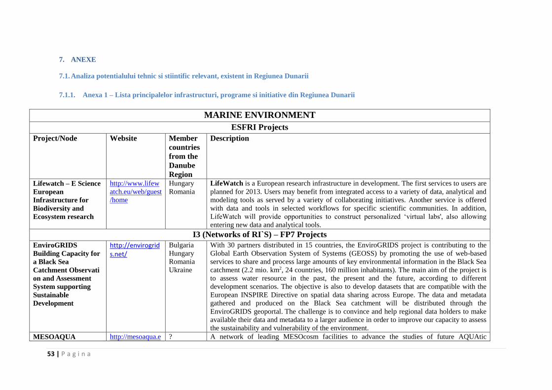
53 | P a g i n a
7. ANEXE
7.1. Analiza potentialului tehnic si stiintific relevant, existent in Regiunea Dunarii
7.1.1. Anexa 1 – Lista principalelor infrastructuri, programe si initiative din Regiunea Dunarii
MARINE ENVIRONMENT
ESFRI Projects
Project/Node Website Member
countries
from the
Danube
Region
Description
Lifewatch – E Science
European
Infrastructure for
Biodiversity and
Ecosystem research
http://www.lifew
atch.eu/web/guest
/home
Hungary
Romania
LifeWatch is a European research infrastructure in development. The first services to users are
planned for 2013. Users may benefit from integrated access to a variety of data, analytical and
modeling tools as served by a variety of collaborating initiatives. Another service is offered
with data and tools in selected workflows for specific scientific communities. In addition,
LifeWatch will provide opportunities to construct personalized ‘virtual labs', also allowing
entering new data and analytical tools.
I3 (Networks of RI`S) – FP7 Projects
EnviroGRIDS
Building Capacity for
a Black Sea
Catchment Observati
on and Assessment
System supporting
Sustainable
Development
http://envirogrids.net/
Bulgaria
Hungary
Romania
Ukraine
With 30 partners distributed in 15 countries, the EnviroGRIDS project is contributing to the
Global Earth Observation System of Systems (GEOSS) by promoting the use of web-based
services to share and process large amounts of key environmental information in the Black Sea
catchment (2.2 mio. km2, 24 countries, 160 million inhabitants). The main aim of the project is
to assess water resource in the past, the present and the future, according to different
development scenarios. The objective is also to develop datasets that are compatible with the
European INSPIRE Directive on spatial data sharing across Europe. The data and metadata
gathered and produced on the Black Sea catchment will be distributed through the
EnviroGRIDS geoportal. The challenge is to convince and help regional data holders to make
available their data and metadata to a larger audience in order to improve our capacity to assess
the sustainability and vulnerability of the environment.
MESOAQUA http://mesoaqua.e ? A network of leading MESOcosm facilities to advance the studies of future AQUAtic
54 | P a g i n a
u/ ecosystems from the Arctic to the Mediterranean.
Eurofleets (and
Eurofleets 2)
http://www.eurofl
eets.eu/np4/home
.html
Bulgaria
Romania
Aim: bringing together the EU research fleets to enhance their coordination and promote the
cost effective use of their facilities. It is a research infrastructure project under the FP7.
SeaDataNet 2
Pan-European
Infrastructure for
Ocean & Marine Data
Management
http://www.seada
tanet.org/
Bulgaria
Romania
SeaDataNet has developed an efficient distributed Marine Data Management Infrastructure for
the management of large and diverse sets of data deriving from in situ and remote observation
of the seas and oceans. Professional data centres, active in data collection, constitute a Pan-
European network providing on-line integrated databases of standardized quality. The on-line
access to in-situ data, meta-data and products is provided through a unique portal
interconnecting the interoperable node platforms constituted by the SeaDataNet data centers.
Data, value added products and dictionaries serve wide uses: e.g. research, model initialisation,
industrial projects, teaching, marine environmental assessment.
Upgrade
BlackSeaScene (and
previous FP6
BlackSea Scene)
http://www.black
seascene.net/
Bulgaria
Romania
Ukraine
The UP-GRADE BS-SCENE project is an FP7 EU funded project running from 2009-
2011 that is building and extending the existing research infrastructure (developed under FP6
project BlackSeaScene 1) with an additional 19 marine environmental institutes/organizations
from the 6 Black Sea countries.
Implementing FP6 RI SeaDataNet project standards regarding common communication
standards and adapted technologies will ensure the datacenters interoperability. Main output
will be on-line access to in-situ and remote sensing data, meta-data and products.
EAST-NMR http://www.east-
nmr.eu
Hungary
Slovakia
Enhancing Access and Services to East European users towards an efficient and coordinated
Pan-European pool of NMR (nuclear magnetic resonance) capacities to enable global
collaborative research & boost technological advancement. Nuclear magnetic resonance
(NMR) spectroscopy is a key technology for research in the modern Life Sciences, with an
increasing impact on human health. This technology is unique in new areas of molecular
systems biology providing detailed insight into protein-protein and protein-ligand interactions.
GROOM http://www.groo
m-
fp7.eu/doku.php
Germany The objective of the GROOM project is to design a new European Research Infrastructure that
uses underwater gliders for collecting oceanographic data. This new infrastructure shall be
beneficial for a large number of marine activities and societal applications, which can be
related to climate change, marine ecosystems, resources, or security and which rely on
academic oceanographic research and/or operational oceanography systems.
GROOM will define the scientific, technological, and legal framework of this European glider
capacity.
GROOM is a key project for building the required observatory network that would allow the
Marine Strategy Framework Directive to be implemented.
GROOM will develop in line with other European and international initiatives supporting
55 | P a g i n a
marine in-situ observations, like in particular Euro-Argo, JERICO, and GOOS.
Joint Programming Initiative JPI OCEANS http://www.jpi-
oceans.eu/progne
tt-jpi-
oceans/About_us/
1253960389448
Germany
Romania
The Joint Programming Initiative Healthy and Productive Seas and Oceans (JPI Oceans) is a
coordinating and integrating platform, open to all EU Member States and Associated
Countries. In its role as a coordination platform, JPI Oceans will focus on making better and
more efficient use of national research budgets, which represent 85% of the marine-maritime
funding within Europe. One of the JPI’s goals is to develop joint research programs in which
countries can be involved on a voluntary basis (variable geometry). Participating countries will
also decide what contribution to make: this may include institutional, project-related or new
funding.
JPI Climate http://www.jpi-
climate.eu
Austria
Germany
JPI Climate is a collaboration between 13 European countries to coordinate jointly their
climate research and fund new transnational research initiatives. Transnational coordination of
the research base aims to overcome research fragmentation, to make better use of precious
public R&D resources and to facilitate cross border collaboration between top scientists. JPI
Climate connects scientific disciplines, enables cross-border research and increases science-
practice interaction. By doing this, it is expected that JPI climate significantly contribute to
underpinning the European efforts to respond to climate change.
JPI Climate:
aims to respond to the knowledge needs of policy and the European society at large to
address climate change
provides a platform to align national research priorities according to a jointly agreed
Strategic Research Agenda (SRA) with the aim of complementing and supporting
initiatives at the European level (ERANET's, FP8, Climate KIC, ESFRI Projects)
facilitates the coordination, collaboration and exploitation of synergies in climate
change research, learning and innovation while working against fragmentation and
duplication of efforts
connecting different disciplinary approaches in natural and social sciences leading to
interdisciplinary research efforts of higher quality and relevance
connecting top researchers and research groups from different European countries,
leading to high quality and efficient research efforts, long term collaborations and a
stronger global position
connecting scientific insights with the demands of policy makers, decision makers and
other stakeholders from local to international levels, leading to more effective policies
Networks of Infrastructures and Users SedNet http://www.sedne Germany SedNet is a European network aimed at incorporating sediment issues and knowledge into

56 | P a g i n a
t.org/ Serbia European strategies to support the achievement of a good environmental status and to develop
new tools for sediment management. Our focus is on all sediment quality and quantity issues
on a river basin scale, ranging from freshwater to estuarine and marine sediments.
ERVO, EU research
Vessels Operators -
Marine research
Infrastructure
Infobase
http://www.euroc
ean.org/np4/60
http://www.rvinf
obase.eurocean.o
rg/
Bulgaria
Germany
Romania
Contains information about every research vessel operated in EU (operator, area of operation,
technical characteristics, contact details)
EMODNet http://www.emod
net-physics.eu/
Bulgaria
Germany
Romania
The EMODnet Physical Parameters portals is aimed at providing layers of physical data and
metadata available for use by public authorities, scientists and industry, and contribute towards
the definition of an operational European Marine Observation and Data Network
(EMODnet) and contribute to developing of the definition of the Global Monitoring for
Environment and Security (GMES) marine core service. The portal is being developed by a
European consortium and operated in a cooperation between EuroGOOS, its Regional
components (ROOSs), and exploiting SeaDataNet and MyOcean infrastructures and services
bringing together many marine data users and providers. The EMODnet Physical Parameters
portal provides access to near real time and archived data series from fixed stations and ferry
box lines in the European Sea and provides OGC services (WMS, WFS, and WCS) for data
discovery, view and download.
Regional Infrastructures MARINEGEOHAZA
RD
1.EUXINUS network
2.GeoPontica network
www.geohazard-
blacksea.eu
Bulgaria
Romania
1. EUXINUS - the Black Sea regional early warning system to marine-geohazards – marine
observatories
2. GeoPontica network - the first on-line geodynamic surveillance network in the entire Black
Sea region
Major Initiatives and Projects in the Danube Area and the Black Sea The Commission on
the Protection of the
Black Sea Against
Pollution
http://www.black
sea-
commission.org/
Bulgaria
Romania
Ukraine
The Commission on the Protection of the Black Sea Against Pollution (the Black Sea
Commission or BSC) via its Permanent Secretariat is the intergovernmental body established in
implementation of the Convention on the Protection of the Black Sea Against Pollution
(Bucharest Convention), its Protocols and the Strategic Action Plan for the Environmental
Protection and Rehabilitation of the Black Sea (latest version adopted in 2009).
HERMES - Hotspot
ecosystem research on
the margins of
http://www.eu-
hermes.net/intro.
html
Germany
Romania
Ukraine
HERMES is designed to gain new insights into the biodiversity, structure, function and
dynamics of ecosystems along Europe's deep-ocean margin. It represents the first major
attempt to understand European deep-water ecosystems and their environment in an integrated
57 | P a g i n a
European seas way by bringing together expertise in biodiversity, geology, sedimentology, physical
oceanography, microbiology and biogeochemistry, so that the generic relationship between
biodiversity and ecosystem functioning can be understood. Study sites will extend from the
Arctic to the Black Sea and include open slopes, where landslides and deep-ocean circulation
affect ecosystem development, and biodiversity hotspots, such as cold seeps, cold-water coral
mounds, canyons and anoxic environments, where the geosphere and hydrosphere influence
the biosphere through escape of fluids, presence of gas hydrates and deep-water currents. These
important systems require urgent study because of their possible biological fragility, unique
genetic resources, global relevance to carbon cycling and possible susceptibility to global
change and man-made disturbances. Past changes, including catastrophic events, will be
assessed using sediment archives. We will make estimates of the flow rates of methane from
the geosphere and calculate how much is utilised by benthic communities, leaving the residual
contribution to reach the atmosphere as a greenhouse gas. HERMES will enable forecasting of
biodiversity change in relation to natural and man-made environmental changes by developing
the first comprehensive pan-European margin Geographic Information System.
This will provide a framework for integrating science, environmental modelling and socio-
economic indicators in ecosystem management. The results will underpin the development of a
comprehensive European Ocean and Seas Integrated Governance Policy enabling risk
assessment, management, conservation and rehabilitation options for margin ecosystems.
Sea Basin Strategy:
Black Sea
http://ec.europa.e
u/maritimeaffairs
/policy/sea_basin
s/black_sea/index
_en.htm
The Black Sea is bordered by 6 countries - including EU members Bulgaria and Romania.
Extensive dialogue and stakeholder involvement is vital for a coherent and coordinated
approach to maritime issues in the area. A first dialogue was held in 2011 with Bulgarian and
Romanian stakeholders, and since then the Commission has extended the dialogue to all Black
Sea countries.
Regional cooperation
The Black Sea Synergy launched by the EU is an initiative for regional cooperation with and
between the countries surrounding the Black Sea. It was designed as a flexible framework to
ensure greater coherence and policy guidance while also inviting a more integrated approach.
The EU also enjoys observer status in two regional organisations:
The Black Sea Economic Cooperation (BSEC)
The Commission for the Protection of the Black Sea Against Pollution (BSC,
Bucharest Convention).
International Initiatives and UN Programmes GEO http://www.earth
observations.org/
GEO was launched in response to calls for action by the 2002 World Summit on Sustainable
Development and by the G8 (Group of Eight) leading industrialized countries. These high-level
58 | P a g i n a
geoss_wa_tar.sht
ml
meetings recognized that international collaboration is essential for exploiting the growing
potential of Earth observations to support decision making in an increasingly complex and
environmentally stressed world. GEO is a voluntary partnership of governments and
international organizations. It provides a framework within which these partners can develop
new projects and coordinate their strategies and investments. As of 2013, GEO’s Members
include 89 Governments and the European Commission. In addition, 67 intergovernmental,
international, and regional organizations with a mandate in Earth observation or related issues
have been recognized as Participating Organizations. GEO is constructing GEOSS on the basis
of a 10-Year Implementation Plan for the period 2005 to 2015. The Plan defines a vision
statement for GEOSS, its purpose and scope, expected benefits, and the nine “Societal Benefit
Areas” of disasters, health, energy, climate, water, weather, ecosystems, agriculture and
biodiversity.
GEOSS http://www.earth
observations.org/
geoss.shtml
The Group on Earth Observations is coordinating efforts to build a Global Earth Observation
System of Systems, or GEOSS. The Global Earth Observation System of Systems will provide
decision-support tools to a wide variety of users. As with the Internet, GEOSS will be a global
and flexible network of content providers allowing decision makers to access an extraordinary
range of information at their desk.
This ‘system of systems’ will proactively link together existing and planned observing systems
around the world and support the development of new systems where gaps currently exist. It
will promote common technical standards so that data from the thousands of different
instruments can be combined into coherent data sets. The ‘GEOPortal’ offers a single Internet
access point for users seeking data, imagery and analytical software packages relevant to all
parts of the globe. It connects users to existing data bases and portals and provides reliable, up-
to-date and user friendly information – vital for the work of decision makers, planners and
emergency managers. For users with limited or no access to the Internet, similar information is
available via the ‘GEONETCast’ network of telecommunication satellites. The Global Earth
Observation System of Systems is simultaneously addressing nine areas of critical importance
to people and society. It aims to empower the international community to protect itself against
natural and human-induced disasters, understand the environmental sources of health hazards,
manage energy resources, respond to climate change and its impacts, safeguard water
resources, improve weather forecasts, manage ecosystems, promote sustainable agriculture and
conserve biodiversity. GEOSS coordinates a multitude of complex and interrelated issues
simultaneously. This cross-cutting approach avoids unnecessary duplication, encourages
synergies between systems and ensures substantial economic, societal and environmental
benefits.
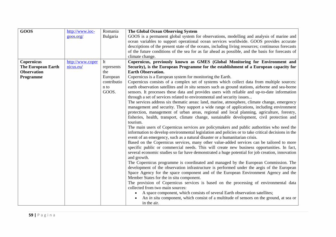
59 | P a g i n a
GOOS http://www.ioc-
goos.org/
Romania
Bulgaria The Global Ocean Observing System
GOOS is a permanent global system for observations, modelling and analysis of marine and
ocean variables to support operational ocean services worldwide. GOOS provides accurate
descriptions of the present state of the oceans, including living resources; continuous forecasts
of the future conditions of the sea for as far ahead as possible, and the basis for forecasts of
climate change.
Copernicus
The European Earth
Observation
Programme
http://www.coper
nicus.eu/
It
represents
the
European
contributio
n to
GOOS.
Copernicus, previously known as GMES (Global Monitoring for Environment and
Security), is the European Programme for the establishment of a European capacity for
Earth Observation.
Copernicus is a European system for monitoring the Earth.
Copernicus consists of a complex set of systems which collect data from multiple sources:
earth observation satellites and in situ sensors such as ground stations, airborne and sea-borne
sensors. It processes these data and provides users with reliable and up-to-date information
through a set of services related to environmental and security issues...
The services address six thematic areas: land, marine, atmosphere, climate change, emergency
management and security. They support a wide range of applications, including environment
protection, management of urban areas, regional and local planning, agriculture, forestry,
fisheries, health, transport, climate change, sustainable development, civil protection and
tourism.
The main users of Copernicus services are policymakers and public authorities who need the
information to develop environmental legislation and policies or to take critical decisions in the
event of an emergency, such as a natural disaster or a humanitarian crisis.
Based on the Copernicus services, many other value-added services can be tailored to more
specific public or commercial needs. This will create new business opportunities. In fact,
several economic studies so far have demonstrated a huge potential for job creation, innovation
and growth.
The Copernicus programme is coordinated and managed by the European Commission. The
development of the observation infrastructure is performed under the aegis of the European
Space Agency for the space component and of the European Environment Agency and the
Member States for the in situ component.
The provision of Copernicus services is based on the processing of environmental data
collected from two main sources:
A space component, which consists of several Earth observation satellites;
An in situ component, which consist of a multitude of sensors on the ground, at sea or
in the air.
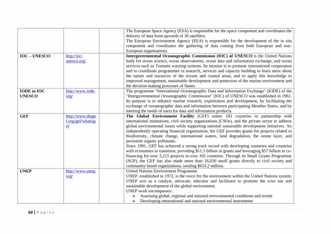
60 | P a g i n a
The European Space Agency (ESA) is responsible for the space component and coordinates the
delivery of data from upwards of 30 satellites.
The European Environment Agency (EEA) is responsible for the development of the in situ
component and coordinates the gathering of data coming from both European and non-
European organisations.
IOC – UNESCO http://ioc-
unesco.org/
Intergovernmental Oceanographic Commission (IOC) of UNESCO is the United Nations
body for ocean science, ocean observatories, ocean data and information exchange, and ocean
services such as Tsunami warning systems. Its mission is to promote international cooperation
and to coordinate programmes in research, services and capacity building to learn more about
the nature and resources of the oceans and coastal areas, and to apply this knowledge to
improved management, sustainable development and protection of the marine environment and
the decision making processes of States.
IODE in IOC
UNESCO
http://www.iode.
org/
The programme "International Oceanographic Data and Information Exchange" (IODE) of the
"Intergovernmental Oceanographic Commission" (IOC) of UNESCO was established in 1961.
Its purpose is to enhance marine research, exploitation and development, by facilitating the
exchange of oceanographic data and information between participating Member States, and by
meeting the needs of users for data and information products.
GEF http://www.thege
f.org/gef/whatisg
ef
The Global Environment Facility (GEF) unites 183 countries in partnership with
international institutions, civil society organizations (CSOs), and the private sector to address
global environmental issues while supporting national sustainable development initiatives. An
independently operating financial organization, the GEF provides grants for projects related to
biodiversity, climate change, international waters, land degradation, the ozone layer, and
persistent organic pollutants.
Since 1991, GEF has achieved a strong track record with developing countries and countries
with economies in transition, providing $11.5 billion in grants and leveraging $57 billion in co-
financing for over 3,215 projects in over 165 countries. Through its Small Grants Programme
(SGP), the GEF has also made more than 16,030 small grants directly to civil society and
community based organizations, totaling $653.2 million.
UNEP http://www.unep.
org/
United Nations Environment Programme
UNEP, established in 1972, is the voice for the environment within the United Nations system.
UNEP acts as a catalyst, advocate, educator and facilitator to promote the wise use and
sustainable development of the global environment.
UNEP work encompasses:
Assessing global, regional and national environmental conditions and trends
Developing international and national environmental instruments
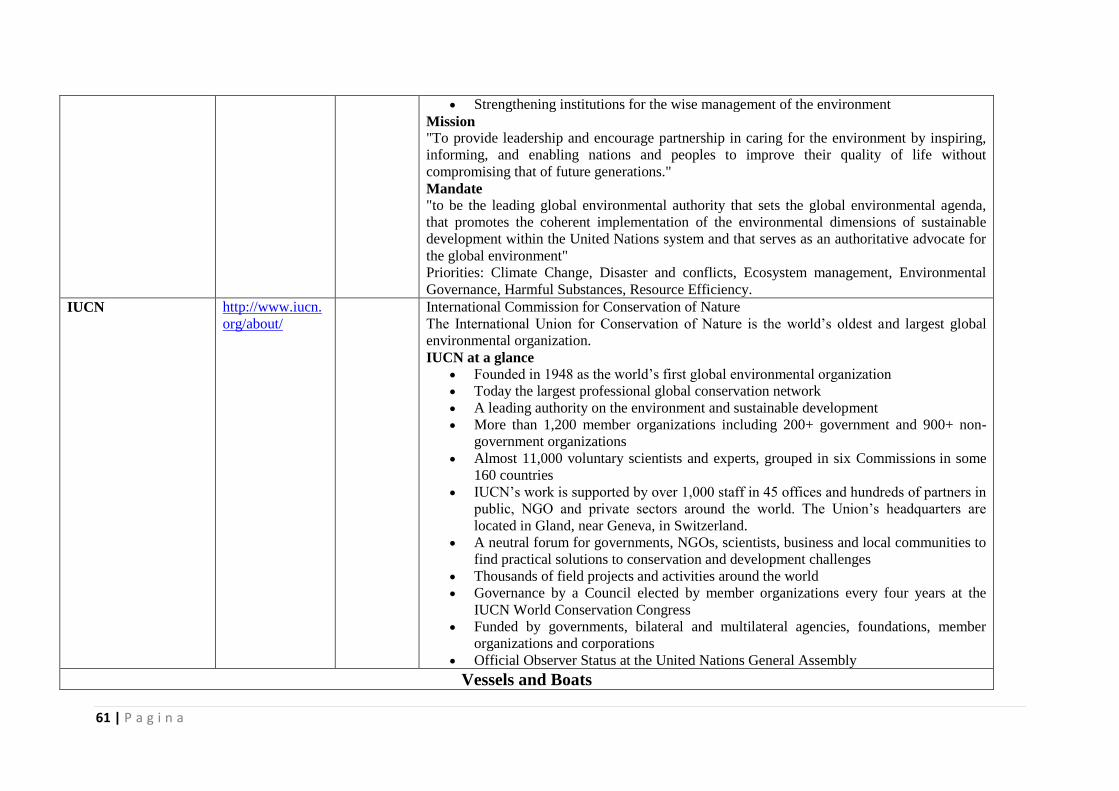
61 | P a g i n a
Strengthening institutions for the wise management of the environment
Mission "To provide leadership and encourage partnership in caring for the environment by inspiring,
informing, and enabling nations and peoples to improve their quality of life without
compromising that of future generations."
Mandate "to be the leading global environmental authority that sets the global environmental agenda,
that promotes the coherent implementation of the environmental dimensions of sustainable
development within the United Nations system and that serves as an authoritative advocate for
the global environment"
Priorities: Climate Change, Disaster and conflicts, Ecosystem management, Environmental
Governance, Harmful Substances, Resource Efficiency.
IUCN http://www.iucn.
org/about/
International Commission for Conservation of Nature
The International Union for Conservation of Nature is the world’s oldest and largest global
environmental organization.
IUCN at a glance
Founded in 1948 as the world’s first global environmental organization
Today the largest professional global conservation network
A leading authority on the environment and sustainable development
More than 1,200 member organizations including 200+ government and 900+ non-
government organizations
Almost 11,000 voluntary scientists and experts, grouped in six Commissions in some
160 countries
IUCN’s work is supported by over 1,000 staff in 45 offices and hundreds of partners in
public, NGO and private sectors around the world. The Union’s headquarters are
located in Gland, near Geneva, in Switzerland.
A neutral forum for governments, NGOs, scientists, business and local communities to
find practical solutions to conservation and development challenges
Thousands of field projects and activities around the world
Governance by a Council elected by member organizations every four years at the
IUCN World Conservation Congress
Funded by governments, bilateral and multilateral agencies, foundations, member
organizations and corporations
Official Observer Status at the United Nations General Assembly
Vessels and Boats
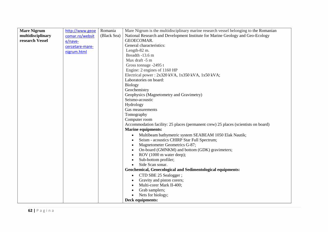
62 | P a g i n a
Mare Nigrum
multidisciplinary
research Vessel
http://www.geoecomar.ro/website/nave-cercetare-mare-nigrum.html
Romania
(Black Sea)
Mare Nigrum is the multidisciplinary marine research vessel belonging to the Romanian
National Research and Development Institute for Marine Geology and Geo-Ecology
GEOECOMAR.
General characteristics:
Length-82 m.
Breadth -13.6 m
Max draft -5 m
Gross tonnage -2495 t
Engine: 2 engines of 1160 HP
Electrical power : 2x320 kVA, 1x350 kVA, 1x50 kVA;
Laboratories on board:
Biology
Geochemistry
Geophysics (Magnetometry and Gravimetry)
Seismo-acoustic
Hydrology
Gas measurements
Tomography
Computer room
Accommodation facility: 25 places (permanent crew) 25 places (scientists on board)
Marine equipments:
Multibeam bathymetric system SEABEAM 1050 Elak Nautik;
Seism - acoustics CHIRP Star Full Spectrum;
Magnetometer Geometrics G-87;
On-board (GMNKM) and bottom (GDK) gravimeters;
ROV (1000 m water deep);
Sub-bottom profiler;
Side Scan sonar.
Geochemical, Geoecological and Sedimentological equipments:
CTD SBE 25 Sealogger ;
Gravity and piston corers;
Multi-corer Mark II-400;
Grab samplers;
Nets for biology;
Deck equipments:
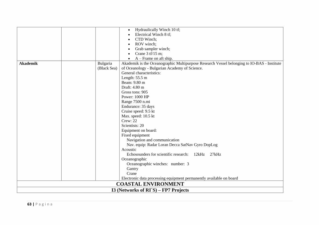
63 | P a g i n a
Hydraulically Winch 10 tf;
Electrical Winch 8 tf;
CTD Winch;
ROV winch;
Grab sampler winch;
Crane 3 tf/15 m;
A – Frame on aft ship.
Akademik Bulgaria
(Black Sea)
Akademik is the Oceanographic Multipurpose Research Vessel belonging to IO-BAS - Institute
of Oceanology - Bulgarian Academy of Science.
General characteristics:
Length: 55.5 m
Beam: 9.80 m
Draft: 4.80 m
Gross tons: 905
Power: 1000 HP
Range 7500 n.mi
Endurance: 35 days
Cruise speed: 9.5 kt
Max. speed: 10.5 kt
Crew: 22
Scientists: 20
Equipment on board:
Fixed equipment
Navigation and communication
Nav. equip: Radar Loran Decca SatNav Gyro DopLog
Acoustic
Echosounders for scientific research: 12kHz 27kHz
Oceanographic
Oceanographic winches: number: 3
Gantry
Crane
Electronic data processing equipment permanently available on board
COASTAL ENVIRONMENT
I3 (Networks of RI`S) – FP7 Projects
64 | P a g i n a
HYDRALAB IV Infrastructure Network
http://www.hydra
lab.eu
Hungary
Romania
The co-ordinated and integrated approach of HYDRALAB aims at structuring the access to
unique and costly hydraulic and ice engineering research infrastructures in the European
Research Area. The network of HYDRALAB is unique in the hydraulic research community
and has large experience in co-operating since its start in 1997. It began by informing and co-
ordinating the activities of the partners in HYDRALAB I and II, and via strong collaboration in
HYDRALAB III we will now realize further integration of our research services in Europe in
HYDRALAB IV. Research in this infrastructures deals with complex questions regarding the
interaction of water with environmental elements, sediment, structures and ice and goes beyond
just hydraulic research: hence we have adopted the theme More than water, with the following
elements: water and environmental elements (focusing on ecology and biology); water and
sediment; water and structures; water and ice.
JERICO – Towards a
joint EU research
infrastructure
network for coastal
observatories
http://www.jerico
-fp7.eu/
Bulgaria
Germany
Around European coastal seas, the number of marine observing systems is quickly increasing
under the pressure of both monitoring requirements and oceanographic research. Present
demands for such systems include reliable, high-quality and comprehensive observations,
automated platforms and sensors systems, as well as autonomy over long time periods. In-situ
data collected, combined with remote sensing and models output, contribute to detect,
understand and forecast the most crucial coastal processes over extensive areas within the
various national and regional marine environments. Coastal observations are an important part
of the marine research puzzle of activities and applications. However significant heterogeneity
exists in Europe concerning technological design of observing systems, measured parameters,
practices for maintenance and quality control, as well as quality standards for sensors and data
exchange.
Pegaso http://www.pegas
oproject.eu
Romania
(Danube
Delta is a
Pegaso
pilot site)
Ukraine
Many efforts have been deployed for developing Integrated Coastal Zone Management in
the Mediterranean and the Black Sea.
Both basins have, and continue to suffer severe environmental degradation. In many areas this
has led to unsustainable trends, which have impacted, on economic activities and human well-
being. An important progress has been made with the launch of the ICZM Protocol for the
Mediterranean Sea in January 2008.
The main goal of the PEGASO project is to construct a shared Integrated Coastal Zone
Management (ICZM) Governance Platform with scientists, users and decision-makers linked
with new models of governance.
Spatial Data Infrastructure for the Mediterranean and Black Seas
The PEGASO project is an example initiative for the Mediterranean and Black Seas that aims
to build a shared ICZM Governance Platform with scientists and end-users, linked with new
models of governance. The PEGASO ICZM Platform will be supported by the development
65 | P a g i n a
of a Spatial Data Infrastructure (SDI) and the suite of sustainability assessment tools
required for making multi-scale integrated assessments in the coastal zone.
RISES – AM
Responses to coastal
climate change:
Innovative Strategies
for high End
Scenarios -Adaptation
and Mitigation
http://risesam.eu/ Germany
Romania
Coastal areas concentrate vulnerability to climate change due to high levels of population,
economic activity and ecological values. Because of that RISES-AM addresses the economy-
wide impacts of coastal systems to various types of high-end climatic scenarios (including
marine and riverine variables). The emphasis is on the advantages of flexible management with
novel types of coastal interventions (e.g. “green” options) within an adaptive pathway whose
tipping points will be identified/quantified in the project. The extended/improved suite of
models will be applied across scales and focusing on the most vulnerable coastal archetypes
such as deltas, estuaries, port cities and small islands. This will lead to a motivated analysis of
the synergies and trade-off between mitigation and adaptation, including what level and timing
of climate mitigation is needed to avoid social, ecological and economic adaptation tipping
points in coastal areas. The project shall evaluate the direct and indirect costs of high-end
scenarios (e.g. the increasing demand for safety under increasingly adverse conditions) for
coasts with/without climate change and contribute to determining which policy responses are
needed at the European and global levels in the context of international climate discussions.
The project will finally transfer results to authorities, users and stakeholders from all economic
sectors converging in coastal zones, including the climate research community.
FAST - Foreshore
Assessment using
Space Technology
www.fast-space-project.eu
Romania Reducing flood risk is now one of the most pressing challenges facing European coastal
managers. Sea level rise, changing weather patterns and increasing coastal populations,
exacerbate this challenge and necessitate innovative approaches towards coastal management.
Natural environments provide the ecosystem service of ‘natural flood defence’. An innovative,
sustainable and cost reduction approach for coastal management strategies is the incorporation
of natural environments into flood risk management. However, to incorporate this approach
into management schemes, we need to know more about the precise mechanisms of energy
dissipation by coastal ecosystems; how these processes ‘scale up’ from individual sites to
larger foreshores seaward of coastal defences; and how we can incorporate such information
into accessible assessment methods for coastal managers. FAST is a multi-disciplinary project
that will help providing know-how to include natural ecosystems within flood safety solutions.
The objective of the FAST project is to utilise field measurements and satellite data - from
eight different foreshores in four different countries (The Netherlands, U.K. Romania and
Spain) - to develop a software tool. The resulting software tool will allow water managers and
consultants to determine the role of vegetated foreshores in reducing flood and erosion risk at
their landward margins.
Vessels and Boats
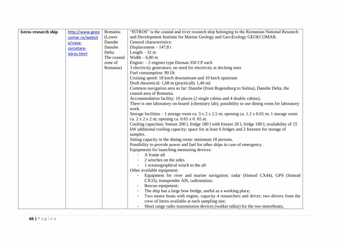
66 | P a g i n a
Istros research ship http://www.geoecomar.ro/website/nave-cercetare-istros.html
Romania
(Lower
Danube
Danube
Delta
The coastal
zone of
Romania)
“ISTROS” is the coastal and river research ship belonging to the Romanian National Research
and Development Institute for Marine Geology and Geo-Ecology GEOECOMAR.
General characteristics:
Displacement – 147,8 t
Length – 32 m
Width – 6,80 m
Engine: – 2 engines type Doosan 350 CP each
3 electricity generators; no need for electricity at docking sites
Fuel consumption: 90 l/h
Cruising speed: 18 km/h downstream and 10 km/h upstream
Draft theoretical: 1,08 m (practically 1,40 m)
Common navigation area so far: Danube (from Regensburg to Sulina), Danube Delta, the
coastal area of Romania.
Accommodation facility: 10 places (2 single cabins and 4 double cabins).
There is one laboratory on-board: (chemistry lab); possibility to use dining room for laboratory
work.
Storage facilities – 1 storage room ca. 3 x 2 x 2.5 m; opening ca. 1.2 x 0.65 m; 1 storage room
ca. 2 x 2 x 2 m; opening ca. 0.65 x 0. 65 m.
Cooling capacities: freezer 200 l, fridge 180 l with freezer 20 l, fridge 180 l; availability of 15
kW additional cooling capacity; space for at least 6 fridges and 2 freezers for storage of
samples.
Sitting capacity in the dining room: minimum 18 persons.
Possibility to provide power and fuel for other ships in case of emergency.
Equipments for launching measuring devices:
- A frame aft
- 2 winches on the sides
- 1 oceanographical winch to the aft
Other available equipment:
- Equipment for river and marine navigation: radar (Simrad CX44), GPS (Simrad
CX33), transponder AIS, radiostation;
- Rescue equipment;
- The ship has a large bow bridge, useful as a working place;
- Two motor boats with engine, capacity 4 researchers and driver; two drivers from the
crew of Istros available at each sampling site;
- Short range radio transmission devices (walkie talkie) for the two motorboats;
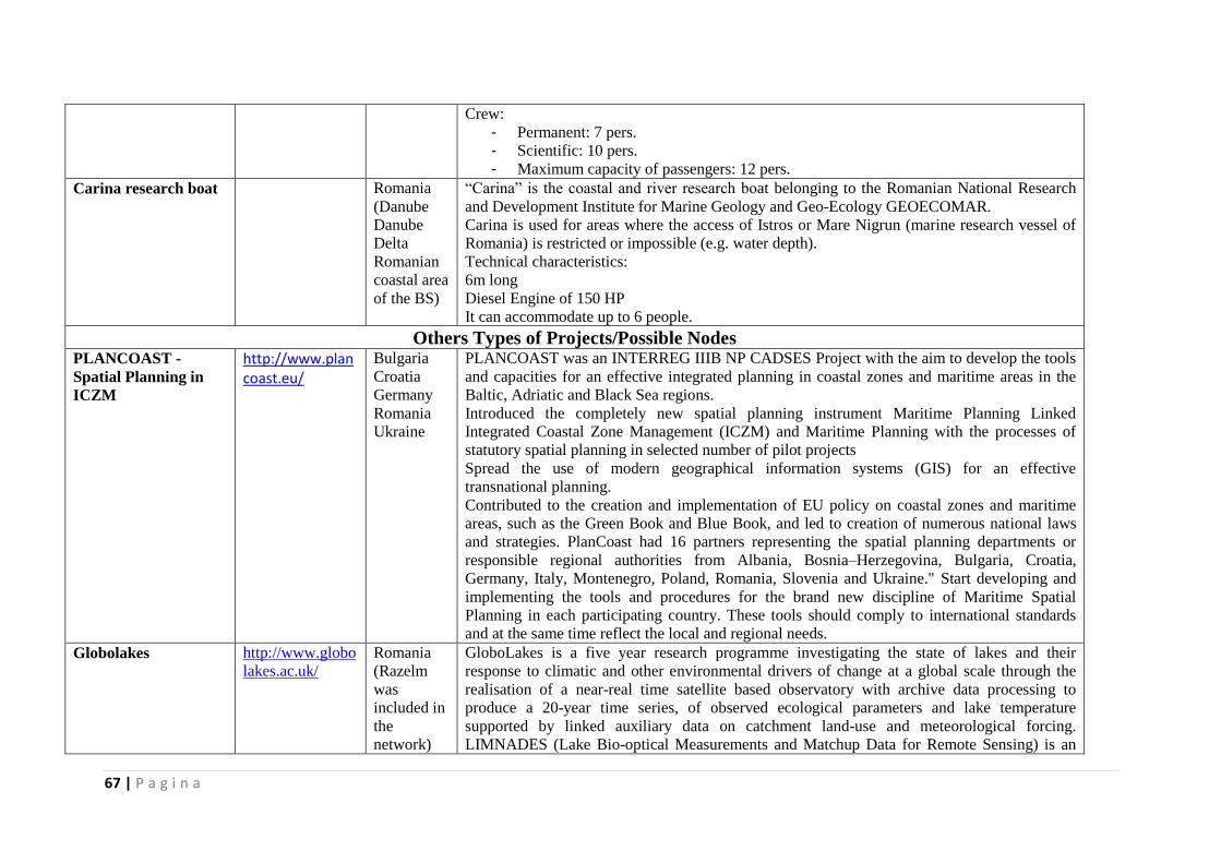
67 | P a g i n a
Crew:
- Permanent: 7 pers.
- Scientific: 10 pers.
- Maximum capacity of passengers: 12 pers. Carina research boat Romania
(Danube
Danube
Delta
Romanian
coastal area
of the BS)
“Carina” is the coastal and river research boat belonging to the Romanian National Research
and Development Institute for Marine Geology and Geo-Ecology GEOECOMAR.
Carina is used for areas where the access of Istros or Mare Nigrun (marine research vessel of
Romania) is restricted or impossible (e.g. water depth).
Technical characteristics:
6m long
Diesel Engine of 150 HP
It can accommodate up to 6 people.
Others Types of Projects/Possible Nodes PLANCOAST -
Spatial Planning in
ICZM
http://www.plancoast.eu/
Bulgaria
Croatia
Germany
Romania
Ukraine
PLANCOAST was an INTERREG IIIB NP CADSES Project with the aim to develop the tools
and capacities for an effective integrated planning in coastal zones and maritime areas in the
Baltic, Adriatic and Black Sea regions.
Introduced the completely new spatial planning instrument Maritime Planning Linked
Integrated Coastal Zone Management (ICZM) and Maritime Planning with the processes of
statutory spatial planning in selected number of pilot projects
Spread the use of modern geographical information systems (GIS) for an effective
transnational planning.
Contributed to the creation and implementation of EU policy on coastal zones and maritime
areas, such as the Green Book and Blue Book, and led to creation of numerous national laws
and strategies. PlanCoast had 16 partners representing the spatial planning departments or
responsible regional authorities from Albania, Bosnia–Herzegovina, Bulgaria, Croatia,
Germany, Italy, Montenegro, Poland, Romania, Slovenia and Ukraine." Start developing and
implementing the tools and procedures for the brand new discipline of Maritime Spatial
Planning in each participating country. These tools should comply to international standards
and at the same time reflect the local and regional needs.
Globolakes http://www.globo
lakes.ac.uk/
Romania
(Razelm
was
included in
the
network)
GloboLakes is a five year research programme investigating the state of lakes and their
response to climatic and other environmental drivers of change at a global scale through the
realisation of a near-real time satellite based observatory with archive data processing to
produce a 20-year time series, of observed ecological parameters and lake temperature
supported by linked auxiliary data on catchment land-use and meteorological forcing.
LIMNADES (Lake Bio-optical Measurements and Matchup Data for Remote Sensing) is an
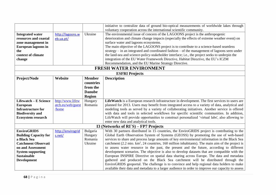
68 | P a g i n a
initiative to centralize data of ground bio-optical measurements of worldwide lakes through
voluntary cooperation across the international scientific community.
Integrated water
resources and coastal
zone management in
European lagoons in
the
context of climate
change
http://lagoons.web.ua.pt/
Ukraine
The environmental issue of concern of the LAGOONS project is the anthropogenic
deterioration and climate change impacts (especially the effects of extreme weather event) on
surface water and lagoons ecosystems.
The main objective of the LAGOONS project is to contribute to a science-based seamless
strategy – in an integrated and coordinated fashion – of the management of lagoons seen under
the land-sea and science-policy-stakeholder interface; i.e., the project seeks to underpin the
integration of the EU Water Framework Directive, Habitat Directive, the EU’s ICZM
Recommendation, and the EU Marine Strategy Directive.
FRESH WATER ENVIRONMENT
ESFRI Projects
Project/Node Website Member
countries
from the
Danube
Region
Description
Lifewatch – E Science
European
Infrastructure for
Biodiversity and
Ecosystem research
http://www.lifew
atch.eu/web/guest
/home
Hungary
Romania
LifeWatch is a European research infrastructure in development. The first services to users are
planned for 2013. Users may benefit from integrated access to a variety of data, analytical and
modeling tools as served by a variety of collaborating initiatives. Another service is offered
with data and tools in selected workflows for specific scientific communities. In addition,
LifeWatch will provide opportunities to construct personalized ‘virtual labs', also allowing to
enter new data and analytical tools.
I3 (Networks of RI`S) – FP7 Projects EnviroGRIDS
Building Capacity for
a Black Sea
Catchment Observati
on and Assessment
System supporting
Sustainable
Development
http://envirogrids.net/
Bulgaria
Hungary
Romania
Ukraine
With 30 partners distributed in 15 countries, the EnviroGRIDS project is contributing to the
Global Earth Observation System of Systems (GEOSS) by promoting the use of web-based
services to share and process large amounts of key environmental information in the Black Sea
catchment (2.2 mio. km2, 24 countries, 160 million inhabitants). The main aim of the project is
to assess water resource in the past, the present and the future, according to different
development scenarios. The objective is also to develop datasets that are compatible with the
European INSPIRE Directive on spatial data sharing across Europe. The data and metadata
gathered and produced on the Black Sea catchment will be distributed through the
EnviroGRIDS geoportal. The challenge is to convince and help regional data holders to make
available their data and metadata to a larger audience in order to improve our capacity to assess

69 | P a g i n a
the sustainability and vulnerability of the environment.
MESOAQUA http://mesoaqua.e
u/
? A network of leading MESOcosm facilities to advance the studies of future AQUAtic
ecosystems from the Arctic to the Mediterranean.
ExpeER Ecosystem
Research
http://www.expee
ronline.eu/
Austria
Hungary
Romania
Serbia
ExpeER is a major European Infrastructure project (2010-2014) in the field of Ecosystem
Research. ExpeER will, for the first time, federate existing national infrastructures, improve
their research capacity whilst at the same time facilitating access to those key experimental and
observational platforms as well as analytical and modelling facilities for the benefit of the
international research community.
EAST-NMR http://www.east-
nmr.eu
Hungary
Slovakia
Enhancing Access and Services to East European users towards an efficient and coordinated
Pan-European pool of NMR (nuclear magnetic resonance) capacities to enable global
collaborative research & boost technological advancement. Nuclear magnetic resonance
(NMR) spectroscopy is a key technology for research in the modern Life Sciences, with an
increasing impact on human health. This technology is unique in new areas of molecular
systems biology providing detailed insight into protein-protein and protein-ligand interactions.
ClimateWater -
Bridging the gap
between adaptation
strategies of climate
change impacts and
European water
policies
http://www.clima
tewater.org/proje
ct.php
Austria
Germany
Hungary
Romania
The overall objective of the ClimateWater project is to study European and international
adaptation measures and strategies related to climate change impacts and how these are taken
into account in water policies. The project will formulate a coherent framework on adaptation
strategies of climate change impacts on water resources, water cycling and water uses of the
society and nature with special regard to those that water policy has to take into account when
considering climate change impacts. The project will bring together scientific and policy
experiences on the existing and/or missing links between climate change and water
management and will help to:
• identify research needs on climate change impacts on water cycle and resources,
•develop and apply methodologies for adaptation measures to climate change,
•develop scenarios of water demand and to potential implementation on water policies.
PSI-Connect* (FP7,
GA 226915): Policy
Science Interactions:-
Connecting science
and
policy through
innovative knowledge
brokering
http://public.cranf
ield.ac.uk/e10173
2/psi%20connect/
documents/d3.2_
national_level.pd
f
http://www.psico
nnect.eu/
Germany
Hungary
Bridging the policy-science gap
The inherent ecological and societal complexity of water management challenges means
that management decisions are always challenged by a lack of factual knowledge. This
situation is exacerbated by rapidly changing physical and socio-economic boundary
conditions such as climate change. Although much new knowledge on the issue of climate
change impacts on water resources has been generated, these understandings remain poorly
exploited by policy makers and water managers. In recent years, considerable effort has
been devoted to designing approaches that support dialogue between science and policy
communities in an attempt to relate science, experience and insight to policy. Knowledge
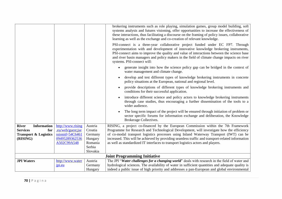
70 | P a g i n a
brokering instruments such as role playing, simulation games, group model building, soft
systems analysis and futures visioning, offer opportunities to increase the effectiveness of
these interactions, thus facilitating a discourse on the framing of policy issues, collaborative learning as well as the exchange and co-creation of relevant knowledge.
PSI-connect is a three-year collaborative project funded under EC FP7. Through
experimentation with and development of innovative knowledge brokering instruments,
PSI-connect aims to improve the quality and value of interactions between the science base
and river basin managers and policy makers in the field of climate change impacts on river systems. PSI-connect will:
generate insight into how the science policy gap can be bridged in the context of water management and climate change.
develop and test different types of knowledge brokering instruments in concrete
policy situations at the European, national and regional level.
provide descriptions of different types of knowledge brokering instruments and
conditions for their successful application.
introduce different science and policy actors to knowledge brokering instruments
through case studies, thus encouraging a further dissemination of the tools to a
wider audience.
The long term impact of the project will be ensured through initiation of problem or
sector specific forums for information exchange and deliberation, the Knowledge Brokerage Collectives.
River Information
Services for
Transport & Logistics
(RISING)
http://www.rising
.eu/web/guest;jse
ssionid=54C6461
09495289362536
A502C99A548
Austria
Croatia
Germany
Hungary
Romania
Serbia
Slovakia
RISING, a project co-financed by the European Commission within the 7th Framework
Programme for Research and Technological Development, will investigate how the efficiency
of co-modal transport logistics processes using Inland Waterway Transport (IWT) can be
increased. This will be achieved by providing seamless traffic and transport-related information
as well as standardized IT interfaces to transport logistics actors and players.
Joint Programming Initiative JPI Waters http://www.water
jpi.eu
Austria
Germany
Hungary
The JPI “Water challenges for a changing world” deals with research in the field of water and
hydrological sciences. The availability of water in sufficient quantities and adequate quality is
indeed a public issue of high priority and addresses a pan-European and global environmental
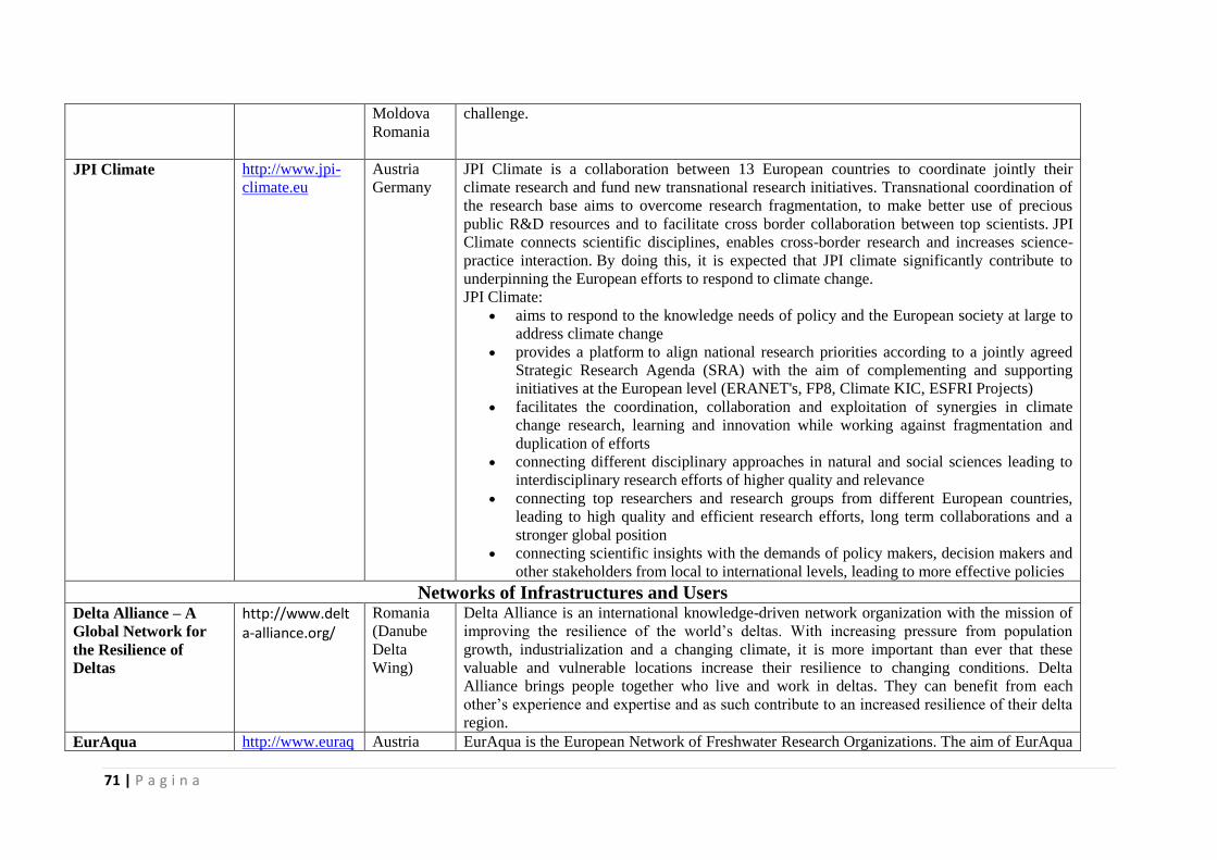
71 | P a g i n a
Moldova
Romania
challenge.
JPI Climate http://www.jpi-
climate.eu
Austria
Germany
JPI Climate is a collaboration between 13 European countries to coordinate jointly their
climate research and fund new transnational research initiatives. Transnational coordination of
the research base aims to overcome research fragmentation, to make better use of precious
public R&D resources and to facilitate cross border collaboration between top scientists. JPI
Climate connects scientific disciplines, enables cross-border research and increases science-
practice interaction. By doing this, it is expected that JPI climate significantly contribute to
underpinning the European efforts to respond to climate change.
JPI Climate:
aims to respond to the knowledge needs of policy and the European society at large to
address climate change
provides a platform to align national research priorities according to a jointly agreed
Strategic Research Agenda (SRA) with the aim of complementing and supporting
initiatives at the European level (ERANET's, FP8, Climate KIC, ESFRI Projects)
facilitates the coordination, collaboration and exploitation of synergies in climate
change research, learning and innovation while working against fragmentation and
duplication of efforts
connecting different disciplinary approaches in natural and social sciences leading to
interdisciplinary research efforts of higher quality and relevance
connecting top researchers and research groups from different European countries,
leading to high quality and efficient research efforts, long term collaborations and a
stronger global position
connecting scientific insights with the demands of policy makers, decision makers and
other stakeholders from local to international levels, leading to more effective policies
Networks of Infrastructures and Users Delta Alliance – A
Global Network for
the Resilience of
Deltas
http://www.delta-alliance.org/
Romania
(Danube
Delta
Wing)
Delta Alliance is an international knowledge-driven network organization with the mission of
improving the resilience of the world’s deltas. With increasing pressure from population
growth, industrialization and a changing climate, it is more important than ever that these
valuable and vulnerable locations increase their resilience to changing conditions. Delta
Alliance brings people together who live and work in deltas. They can benefit from each
other’s experience and expertise and as such contribute to an increased resilience of their delta
region.
EurAqua http://www.euraq Austria EurAqua is the European Network of Freshwater Research Organizations. The aim of EurAqua
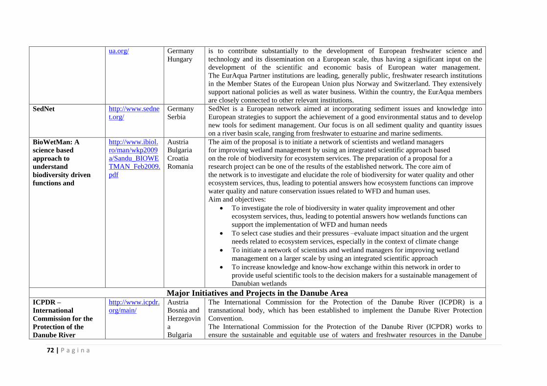
72 | P a g i n a
ua.org/ Germany
Hungary
is to contribute substantially to the development of European freshwater science and
technology and its dissemination on a European scale, thus having a significant input on the
development of the scientific and economic basis of European water management.
The EurAqua Partner institutions are leading, generally public, freshwater research institutions
in the Member States of the European Union plus Norway and Switzerland. They extensively
support national policies as well as water business. Within the country, the EurAqua members
are closely connected to other relevant institutions.
SedNet http://www.sedne
t.org/
Germany
Serbia
SedNet is a European network aimed at incorporating sediment issues and knowledge into
European strategies to support the achievement of a good environmental status and to develop
new tools for sediment management. Our focus is on all sediment quality and quantity issues
on a river basin scale, ranging from freshwater to estuarine and marine sediments.
BioWetMan: A
science based
approach to
understand
biodiversity driven
functions and
http://www.ibiol.
ro/man/wkp2009
a/Sandu_BIOWE
TMAN_Feb2009.
Austria
Bulgaria
Croatia
Romania
The aim of the proposal is to initiate a network of scientists and wetland managers
for improving wetland management by using an integrated scientific approach based
on the role of biodiversity for ecosystem services. The preparation of a proposal for a
research project can be one of the results of the established network. The core aim of
the network is to investigate and elucidate the role of biodiversity for water quality and other
ecosystem services, thus, leading to potential answers how ecosystem functions can improve
water quality and nature conservation issues related to WFD and human uses.
Aim and objectives:
To investigate the role of biodiversity in water quality improvement and other
ecosystem services, thus, leading to potential answers how wetlands functions can
support the implementation of WFD and human needs
To select case studies and their pressures –evaluate impact situation and the urgent
needs related to ecosystem services, especially in the context of climate change
To initiate a network of scientists and wetland managers for improving wetland
management on a larger scale by using an integrated scientific approach
To increase knowledge and know-how exchange within this network in order to
provide useful scientific tools to the decision makers for a sustainable management of
Danubian wetlands
Major Initiatives and Projects in the Danube Area ICPDR –
International
Commission for the
Protection of the
Danube River
http://www.icpdr.
org/main/
Austria
Bosnia and
Herzegovin
a
Bulgaria
The International Commission for the Protection of the Danube River (ICPDR) is a
transnational body, which has been established to implement the Danube River Protection
Convention.
The International Commission for the Protection of the Danube River (ICPDR) works to
ensure the sustainable and equitable use of waters and freshwater resources in the Danube
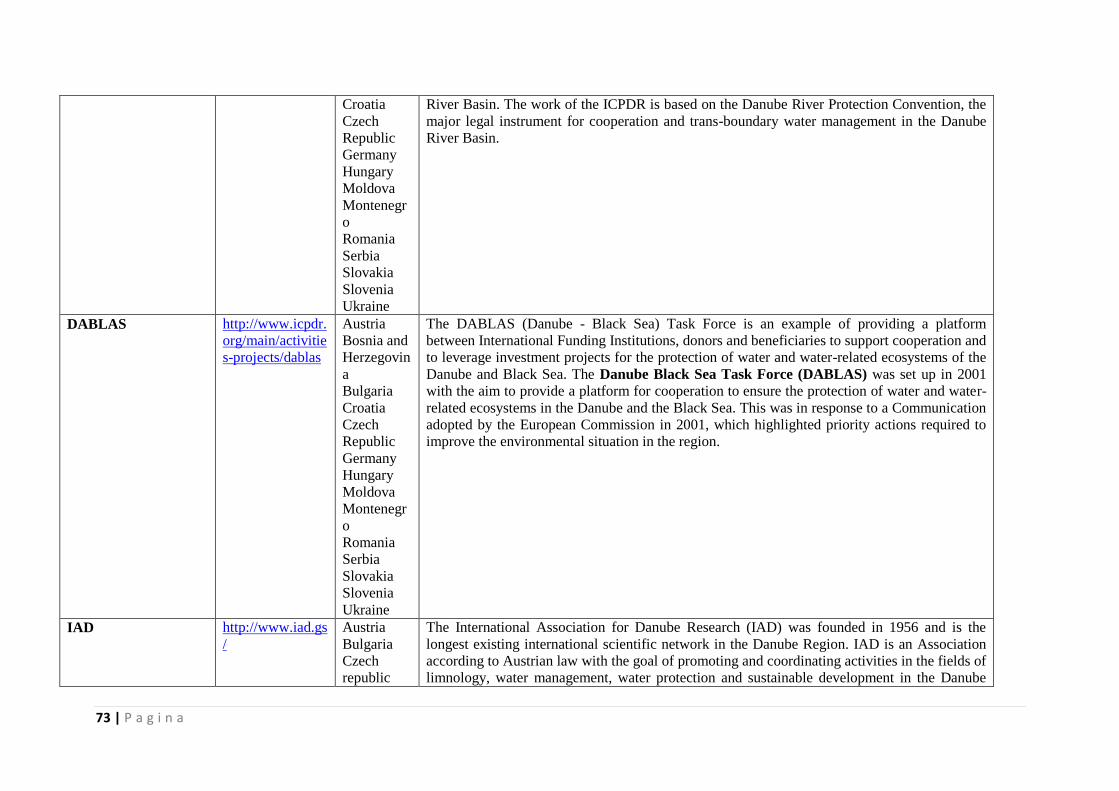
73 | P a g i n a
Croatia
Czech
Republic
Germany
Hungary
Moldova
Montenegr
o
Romania
Serbia
Slovakia
Slovenia
Ukraine
River Basin. The work of the ICPDR is based on the Danube River Protection Convention, the
major legal instrument for cooperation and trans-boundary water management in the Danube
River Basin.
DABLAS http://www.icpdr.
org/main/activitie
s-projects/dablas
Austria
Bosnia and
Herzegovin
a
Bulgaria
Croatia
Czech
Republic
Germany
Hungary
Moldova
Montenegr
o
Romania
Serbia
Slovakia
Slovenia
Ukraine
The DABLAS (Danube - Black Sea) Task Force is an example of providing a platform
between International Funding Institutions, donors and beneficiaries to support cooperation and
to leverage investment projects for the protection of water and water-related ecosystems of the
Danube and Black Sea. The Danube Black Sea Task Force (DABLAS) was set up in 2001
with the aim to provide a platform for cooperation to ensure the protection of water and water-
related ecosystems in the Danube and the Black Sea. This was in response to a Communication
adopted by the European Commission in 2001, which highlighted priority actions required to
improve the environmental situation in the region.
IAD http://www.iad.gs
/
Austria
Bulgaria
Czech
republic
The International Association for Danube Research (IAD) was founded in 1956 and is the
longest existing international scientific network in the Danube Region. IAD is an Association
according to Austrian law with the goal of promoting and coordinating activities in the fields of
limnology, water management, water protection and sustainable development in the Danube
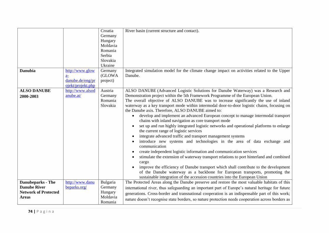
74 | P a g i n a
Croatia
Germany
Hungary
Moldavia
Romania
Serbia
Slovakia
Ukraine
River basin (current structure and contact).
Danubia http://www.glow
a-
danube.de/eng/pr
ojekt/projekt.php
Germany
(GLOWA
project)
Integrated simulation model for the climate change impact on activities related to the Upper
Danube.
ALSO DANUBE
2000-2003
http://www.alsod
anube.at/
Austria
Germany
Romania
Slovakia
ALSO DANUBE (Advanced Logistic Solutions for Danube Waterway) was a Research and
Demonstration project within the 5th Framework Programme of the European Union.
The overall objective of ALSO DANUBE was to increase significantly the use of inland
waterway as a key transport mode within intermodal door-to-door logistic chains, focusing on
the Danube axis. Therefore, ALSO DANUBE aimed to:
develop and implement an advanced European concept to manage intermodal transport
chains with inland navigation as core transport mode
set up and run highly integrated logistic networks and operational platforms to enlarge
the current range of logistic services
integrate advanced traffic and transport management systems
introduce new systems and technologies in the area of data exchange and
communication
create independent logistic information and communication services
stimulate the extension of waterway transport relations to port hinterland and combined
cargo
improve the efficiency of Danube transport which shall contribute to the development
of the Danube waterway as a backbone for European transports, promoting the
sustainable integration of the accession countries into the European Union
Danubeparks - The
Danube River
Network of Protected
Areas
http://www.danu
beparks.org/
Bulgaria
Germany
Hungary
Moldavia
Romania
The Protected Areas along the Danube preserve and restore the most valuable habitats of this
international river, thus safeguarding an important part of Europe’s natural heritage for future
generations. Cross-border and transnational cooperation is an indispensable part of this work;
nature doesn’t recognise state borders, so nature protection needs cooperation across borders as
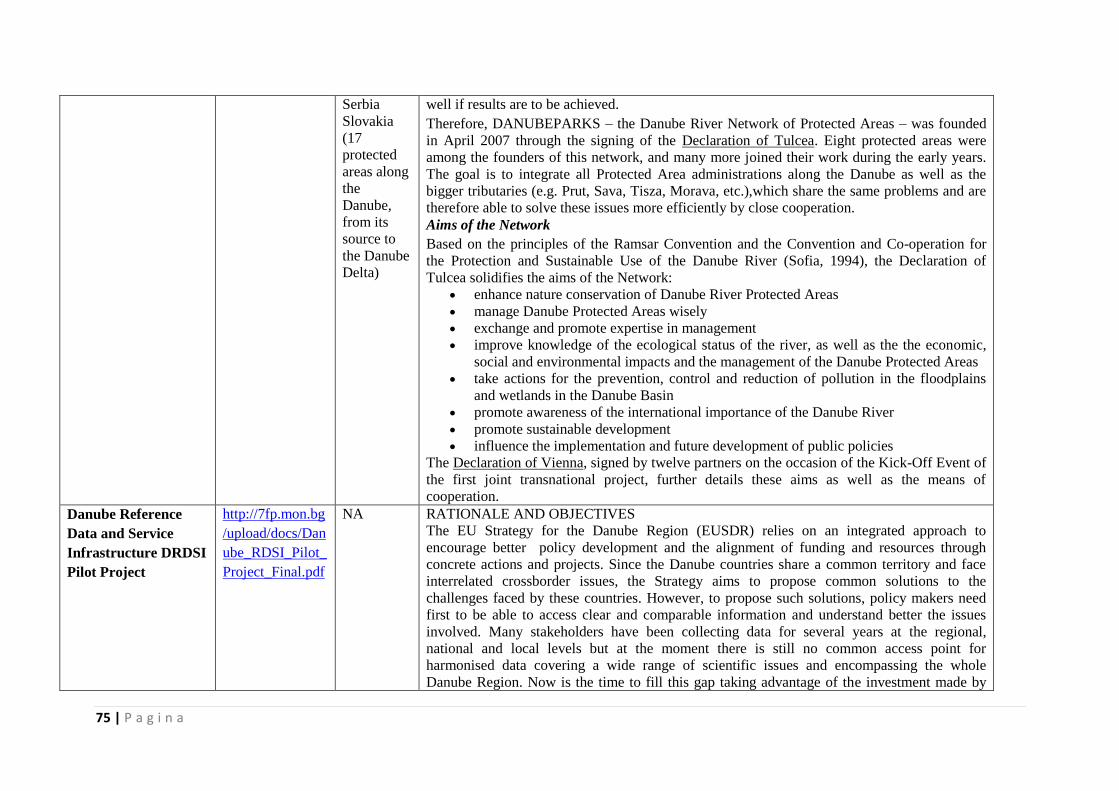
75 | P a g i n a
Serbia
Slovakia
(17
protected
areas along
the
Danube,
from its
source to
the Danube
Delta)
well if results are to be achieved.
Therefore, DANUBEPARKS – the Danube River Network of Protected Areas – was founded
in April 2007 through the signing of the Declaration of Tulcea. Eight protected areas were
among the founders of this network, and many more joined their work during the early years.
The goal is to integrate all Protected Area administrations along the Danube as well as the
bigger tributaries (e.g. Prut, Sava, Tisza, Morava, etc.),which share the same problems and are
therefore able to solve these issues more efficiently by close cooperation.
Aims of the Network
Based on the principles of the Ramsar Convention and the Convention and Co-operation for
the Protection and Sustainable Use of the Danube River (Sofia, 1994), the Declaration of
Tulcea solidifies the aims of the Network:
enhance nature conservation of Danube River Protected Areas
manage Danube Protected Areas wisely
exchange and promote expertise in management
improve knowledge of the ecological status of the river, as well as the the economic,
social and environmental impacts and the management of the Danube Protected Areas
take actions for the prevention, control and reduction of pollution in the floodplains
and wetlands in the Danube Basin
promote awareness of the international importance of the Danube River
promote sustainable development
influence the implementation and future development of public policies
The Declaration of Vienna, signed by twelve partners on the occasion of the Kick-Off Event of
the first joint transnational project, further details these aims as well as the means of
cooperation.
Danube Reference
Data and Service
Infrastructure DRDSI
Pilot Project
http://7fp.mon.bg
/upload/docs/Dan
ube_RDSI_Pilot_
Project_Final.pdf
NA RATIONALE AND OBJECTIVES
The EU Strategy for the Danube Region (EUSDR) relies on an integrated approach to
encourage better policy development and the alignment of funding and resources through
concrete actions and projects. Since the Danube countries share a common territory and face
interrelated crossborder issues, the Strategy aims to propose common solutions to the
challenges faced by these countries. However, to propose such solutions, policy makers need
first to be able to access clear and comparable information and understand better the issues
involved. Many stakeholders have been collecting data for several years at the regional,
national and local levels but at the moment there is still no common access point for
harmonised data covering a wide range of scientific issues and encompassing the whole
Danube Region. Now is the time to fill this gap taking advantage of the investment made by
76 | P a g i n a
Member States to implement INSPIRE and recent progresses on ICT standardisation. For this
reason, the JRC with the support of scientific partners of the Danube countries launched this
project to develop a Danube Data and Services Infrastructure (DRDSI) that will facilitate
access to comparable and harmonised datasets on various issues related to the Danube Region.
Thanks to its cross cutting nature, this Infrastructure will contribute to the holistic scientific
approach needed to tackle the interrelated and interdependent challenges which the Danube
Region is facing. The DRDSI project was proposed as one of the flagship actions of Priority
Area 07 "To develop the Knowledge Society (research, education and ICT)" of the EUSDR
and is mentioned in the Roadmap for the implementation of this Priority Area.
In particular the Priority Area 7 Progress Report was referring to the following
recommendation:“Need to obtain a better overview of all research, initiatives and resources
which are available and to gather the existing research results on the Danube Region in a
structured and harmonised data set which could [be] used by policy makers across the Danube
Region and will serve as a starting ground for the launch of large scale projects in the future”.
The recent report (COM(2013) 181 8/4/2013) from the Commission on the progresses made in
the implementation of the EUSDR pinpoints the DRDSI initiative as one of the new projects
contributing to the strengthening of the Danube Region.
Danube Floodrisk http://www.danu
be-
floodrisk.eu/2009
/11/about/
Austria
Bulgaria
Croatia
Hungary
Moldavia
Romania
Slovakia
Ukraine
The DANUBE FLOODRISK project focuses on the most cost-effective measures for flood risk
reduction: risk assessment, risk mapping, involvement of stakeholders, risk reduction by
adequate spatial planning.
Risk reduction in large international river basins can only be achieved through transnational,
interdisciplinary and stakeholder oriented approaches within the framework of a joint
transnational project. Practice has shown that starting this kind of cooperation is extremely
difficult, due to practical, political and financial reasons. If incentives exist, like the
transnational cooperation programme, the start up can be successful. The long term process
will be self-running after the starting phase.
The project will bring together scientists, public servants, NGOs and stakeholders who develop
jointly a scalable system of flood risk maps for the Danube River floodplains. Transnational
methodology and models will be defined and implemented for flood risk assessment and
mapping. This results in proposals for flood mitigation measures, adjustments of spatial
development plans, assessment tools for economic development in flood plains and raised
awareness of flood risk of stakeholders, politicians, planners and the public. Infrastructures at
risk like industry, power stations and supply infrastructure will be considered in the project.
Partners: 19 institutions all along the Danube countries, central public bodies, universities,
research institutes and operational agencies, NGOs are implicated in the project. Lead partner
77 | P a g i n a
is the Ministry of Environment, Romania.
Others Types of Projects/Possible Nodes LTER Europe http://www.lter-
europe.net/
Austria
Bulgaria
Germany
Hungary
Romania
(Danube
Delta and
Braila
Island)
Serbia
Slovakia
Long-Term Ecosystem Research (LTER) is an essential component of world wide efforts to
better understand ecosystems. This comprises their structure, functions, and response to
environmental, societal and economic drivers as well as the development of management
options. For the first two decades of its existence LTER built on natural sciences. The ongoing
re-design of LTER aims at expanding its scope to the human dimension. Strongly coupled and
integrated socio-ecological systems are driven by economic, cultural and environmental forces
likewise. Their investigation requires a new generation of socio-economic and ecological
research (LTSER) with adequate infrastructure.
LTER-Europe is a network of:
National networks and the European contribution to the global International Long
Term Ecological Research (ILTER) with over half of the ILTER members belonging
to LTER-Europe
Research infrastructures (LTER sites and LTSER platforms forming national
networks)
Institutions involved in ecological research across the continent and aiming at a virtual
European ecological research institute
Researchers in natural sciences, sociology and economy
Scientific site co-ordinators and research platform managers
Long-term data
Research projects
Support for communication and lobbying.
WISER – Water
bodies in Europe:
integrative systems to
assess ecological
status and recovery
Integrated Project to
Evaluate the Impacts
of Global Change on
European Freshwater
Ecosystems Integrated
Project to Evaluate
the Impacts of Global
http://www.wiser
.eu/programme/
Austria
Bulgaria
Germany
WISER will support the implementation of the Water Framework Directive (WFD) by
developing tools for the integrated assessment of the ecological status of European surface
waters (with a focus on lakes and coastal/transitional waters), and by evaluating recovery
processes in rivers, lakes and coastal/transitional waters under global change constraints. The
project will (1) analyse existing data from more than 90 databases compiled in previous and
ongoing projects, covering all water categories, Biological Quality Elements (BQEs) and
stressor types and (2) perform targeted field-sampling exercises including all relevant BQEs in
lakes and in coastal/
transitional waters. New assessment systems will be developed and existing systems will be
evaluated for lakes and coastal/transitional waters, with special focus on how uncertainty
affects classification strength, to complete a set of assessment methodologies for these water
categories. Biological recovery processes, in all water
78 | P a g i n a
Change on European
Freshwater
Ecosystems
categories and in different climatic conditions, will be analysed, with focus on mitigation of
hydromorphological and eutrophication pressures. Large-scale data will be used to identify
linkages between pressure variables and BQE responses. Specific case studies, using a variety
of modelling techniques, will address selected pressure response relationships and the efficacy
of mitigation measures. The responses of different BQEs and different water categories to
human-induced degradation and mitigation will be compared, with special focus on response
signatures of BQEs within and among water categories. Guidance for the next steps of the
intercalibration
exercise will be given by comparing different intercalibration approaches. Stakeholders will be
included from the outset, by building small teams of stakeholders and project partners
responsible for a group of deliverables, to ensure the applicability and swift implementation of
results.
International Initiatives and UN Programmes GEO http://www.earth
observations.org/
geoss_wa_tar.sht
ml
GEO was launched in response to calls for action by the 2002 World Summit on Sustainable
Development and by the G8 (Group of Eight) leading industrialized countries. These high-level
meetings recognized that international collaboration is essential for exploiting the growing
potential of Earth observations to support decision making in an increasingly complex and
environmentally stressed world. GEO is a voluntary partnership of governments and
international organizations. It provides a framework within which these partners can develop
new projects and coordinate their strategies and investments. As of 2013, GEO’s Members
include 89 Governments and the European Commission. In addition, 67 intergovernmental,
international, and regional organizations with a mandate in Earth observation or related issues
have been recognized as Participating Organizations. GEO is constructing GEOSS on the basis
of a 10-Year Implementation Plan for the period 2005 to 2015. The Plan defines a vision
statement for GEOSS, its purpose and scope, expected benefits, and the nine “Societal Benefit
Areas” of disasters, health, energy, climate, water, weather, ecosystems, agriculture and
biodiversity.
GEOSS http://www.earth
observations.org/
geoss.shtml
The Group on Earth Observations is coordinating efforts to build a Global Earth Observation
System of Systems, or GEOSS. The Global Earth Observation System of Systems will provide
decision-support tools to a wide variety of users. As with the Internet, GEOSS will be a global
and flexible network of content providers allowing decision makers to access an extraordinary
range of information at their desk.
This ‘system of systems’ will proactively link together existing and planned observing systems
around the world and support the development of new systems where gaps currently exist. It
will promote common technical standards so that data from the thousands of different
79 | P a g i n a
instruments can be combined into coherent data sets. The ‘GEOPortal’ offers a single Internet
access point for users seeking data, imagery and analytical software packages relevant to all
parts of the globe. It connects users to existing data bases and portals and provides reliable, up-
to-date and user friendly information – vital for the work of decision makers, planners and
emergency managers. For users with limited or no access to the Internet, similar information is
available via the ‘GEONETCast’ network of telecommunication satellites. The Global Earth
Observation System of Systems is simultaneously addressing nine areas of critical importance
to people and society. It aims to empower the international community to protect itself against
natural and human-induced disasters, understand the environmental sources of health hazards,
manage energy resources, respond to climate change and its impacts, safeguard water
resources, improve weather forecasts, manage ecosystems, promote sustainable agriculture and
conserve biodiversity. GEOSS coordinates a multitude of complex and interrelated issues
simultaneously. This cross-cutting approach avoids unnecessary duplication, encourages
synergies between systems and ensures substantial economic, societal and environmental
benefits.
Copernicus
The European Earth
Observation
Programme
http://www.coper
nicus.eu/
It
represents
the
European
contributio
n to
GOOS.
Copernicus, previously known as GMES (Global Monitoring for Environment and
Security), is the European Programme for the establishment of a European capacity for
Earth Observation.
Copernicus is a European system for monitoring the Earth.
Copernicus consists of a complex set of systems which collect data from multiple sources:
earth observation satellites and in situ sensors such as ground stations, airborne and sea-borne
sensors. It processes these data and provides users with reliable and up-to-date information
through a set of services related to environmental and security issues...
The services address six thematic areas: land, marine, atmosphere, climate change, emergency
management and security. They support a wide range of applications, including environment
protection, management of urban areas, regional and local planning, agriculture, forestry,
fisheries, health, transport, climate change, sustainable development, civil protection and
tourism.
The main users of Copernicus services are policymakers and public authorities who need the
information to develop environmental legislation and policies or to take critical decisions in the
event of an emergency, such as a natural disaster or a humanitarian crisis.
Based on the Copernicus services, many other value-added services can be tailored to more
specific public or commercial needs. This will create new business opportunities. In fact,
several economic studies so far have demonstrated a huge potential for job creation, innovation
and growth.
80 | P a g i n a
The Copernicus programme is coordinated and managed by the European Commission. The
development of the observation infrastructure is performed under the aegis of the European
Space Agency for the space component and of the European Environment Agency and the
Member States for the in situ component.
The provision of Copernicus services is based on the processing of environmental data
collected from two main sources:
A space component, which consists of several Earth observation satellites;
An in situ component, which consist of a multitude of sensors on the ground, at sea or
in the air.
The European Space Agency (ESA) is responsible for the space component and coordinates the
delivery of data from upwards of 30 satellites.
The European Environment Agency (EEA) is responsible for the development of the in situ
component and coordinates the gathering of data coming from both European and non-
European organisations.
IHE – UNESCO http://www.unesc
o-ihe.org/
Institute for Water Education
The mission of UNESCO-IHE is to contribute to the education and training of professionals,
the knowledge base through research and to build the capacity of sector organizations,
knowledge centers and other institutions active in the fields of water, the environment and
infrastructure in developing countries and countries in transition. In support of its mission, the
Institute has three main goals:
Develop innovation, provide new knowledge, and promote the uptake of technologies
and policies that will address the issues of the global water agenda, in particular those
related to the Millennium Development Goals (MDGs) and the post 2015 Sustainable
Development Goals (SDGs);
Seek, evaluate and facilitate responses for the sustainable management of water, to
meet the needs of all sectors of society, particularly the poor;
Strengthen and promote principles of good governance that drive institutional and
management change to support the sustainable management of water.
GEF http://www.thege
f.org/gef/whatisg
ef
The Global Environment Facility (GEF) unites 183 countries in partnership with
international institutions, civil society organizations (CSOs), and the private sector to address
global environmental issues while supporting national sustainable development initiatives. An
independently operating financial organization, the GEF provides grants for projects related to
biodiversity, climate change, international waters, land degradation, the ozone layer, and
persistent organic pollutants.
Since 1991, GEF has achieved a strong track record with developing countries and countries
81 | P a g i n a
with economies in transition, providing $11.5 billion in grants and leveraging $57 billion in co-
financing for over 3,215 projects in over 165 countries. Through its Small Grants Programme
(SGP), the GEF has also made more than 16,030 small grants directly to civil society and
community based organizations, totaling $653.2 million.
UNEP http://www.unep.
org/
United Nations Environment Programme
UNEP, established in 1972, is the voice for the environment within the United Nations system.
UNEP acts as a catalyst, advocate, educator and facilitator to promote the wise use and
sustainable development of the global environment.
UNEP work encompasses:
Assessing global, regional and national environmental conditions and trends
Developing international and national environmental instruments
Strengthening institutions for the wise management of the environment
Mission "To provide leadership and encourage partnership in caring for the environment by inspiring,
informing, and enabling nations and peoples to improve their quality of life without
compromising that of future generations."
Mandate "to be the leading global environmental authority that sets the global environmental agenda,
that promotes the coherent implementation of the environmental dimensions of sustainable
development within the United Nations system and that serves as an authoritative advocate for
the global environment"
Priorities: Climate Change, Disaster and conflicts, Ecosystem management, Environmental
Governance, Harmful Substances, Resource Efficiency.
IUCN http://www.iucn.
org/about/
International Commission for Conservation of Nature
The International Union for Conservation of Nature is the world’s oldest and largest global
environmental organization.
IUCN at a glance
Founded in 1948 as the world’s first global environmental organization
Today the largest professional global conservation network
A leading authority on the environment and sustainable development
More than 1,200 member organizations including 200+ government and 900+ non-
government organizations
Almost 11,000 voluntary scientists and experts, grouped in six Commissions in some
160 countries
IUCN’s work is supported by over 1,000 staff in 45 offices and hundreds of partners in
82 | P a g i n a
public, NGO and private sectors around the world. The Union’s headquarters are
located in Gland, near Geneva, in Switzerland.
A neutral forum for governments, NGOs, scientists, business and local communities to
find practical solutions to conservation and development challenges
Thousands of field projects and activities around the world
Governance by a Council elected by member organizations every four years at the
IUCN World Conservation Congress
Funded by governments, bilateral and multilateral agencies, foundations, member
organizations and corporations
Official Observer Status at the United Nations General Assembly
Vessels and Boats Wien Austria A privet Austrian ship that can support the research programs.
Total length: 20,4 m
Width: 3,8 m
Draught: 1,2 m
Engine: 2x 200 hp
Max. speed (rel. to water surface): 22 km/h downstream.
Meßschiff IV
Austria A privat Austrian fishing ship that can be used in research projects.
Istros research ship http://www.geoecomar.ro/website/nave-cercetare-istros.html
Romania
(Lower
Danube
Danube
Delta
The coastal
zone of
Romania)
“ISTROS” is the coastal and river research ship belonging to the Romanian National Research
and Development Institute for Marine Geology and Geo-Ecology GEOECOMAR.
General characteristics:
Displacement – 147,8 t
Length – 32 m
Width – 6,80 m
Engine: – 2 engines type Doosan 350 CP each
3 electricity generators; no need for electricity at docking sites
Fuel consumption: 90 l/h
Cruising speed: 18 km/h downstream and 10 km/h upstream
Draft theoretical: 1,08 m (practically 1,40 m)
Common navigation area so far: Danube (from Regensburg to Sulina), Danube Delta, the
coastal area of Romania.
Accommodation facility: 10 places (2 single cabins and 4 double cabins).
There is one laboratory on-board: (chemistry lab); possibility to use dining room for laboratory
work.
83 | P a g i n a
Storage facilities – 1 storage room ca. 3 x 2 x 2.5 m; opening ca. 1.2 x 0.65 m; 1 storage room
ca. 2 x 2 x 2 m; opening ca. 0.65 x 0. 65 m.
Cooling capacities: freezer 200 l, fridge 180 l with freezer 20 l, fridge 180 l; availability of 15
kW additional cooling capacity; space for at least 6 fridges and 2 freezers for storage of
samples.
Sitting capacity in the dining room: minimum 18 persons.
Possibility to provide power and fuel for other ships in case of emergency.
Equipments for launching measuring devices:
- A frame aft
- 2 winches on the sides
- 1 oceanographical winch to the aft
Other available equipment:
- Equipment for river and marine navigation: radar (Simrad CX44), GPS (Simrad
CX33), transponder AIS, radiostation;
- Rescue equipment;
- The ship has a large bow bridge, useful as a working place;
- Two motor boats with engine, capacity 4 researchers and driver; two drivers from the
crew of Istros available at each sampling site;
- Short range radio transmission devices (walkie talkie) for the two motorboats;
Crew:
- Permanent: 7 pers.
- Scientific: 10 pers.
- Maximum capacity of passengers: 12 pers. Halmyris floating
laboratory and
pontoon
http://www.geoecomar.ro/website/en/nave-cercetare-halmyris.html
Romania
(Danube
Delta)
Technical characteristics:
Length: 32 m;
Breadth: 6,60 m;
Draught: 0,60 m;
Displacement: 90 t;
Laboratory:
Geochemistry;
Biology;
Facilitys:
Electrical power generator;
Air condition intalations;
Other facilitys:
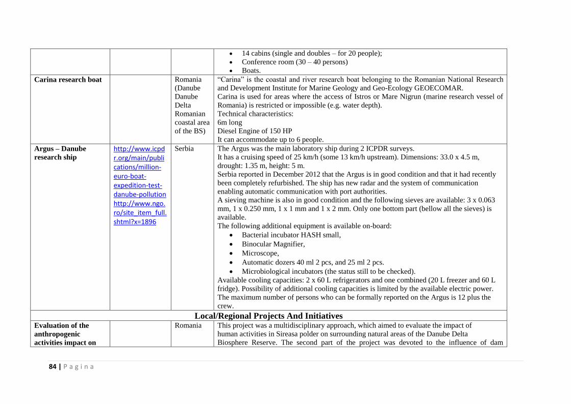
84 | P a g i n a
14 cabins (single and doubles – for 20 people);
Conference room (30 – 40 persons)
Boats. Carina research boat Romania
(Danube
Danube
Delta
Romanian
coastal area
of the BS)
“Carina” is the coastal and river research boat belonging to the Romanian National Research
and Development Institute for Marine Geology and Geo-Ecology GEOECOMAR.
Carina is used for areas where the access of Istros or Mare Nigrun (marine research vessel of
Romania) is restricted or impossible (e.g. water depth).
Technical characteristics:
6m long
Diesel Engine of 150 HP
It can accommodate up to 6 people.
Argus – Danube
research ship
http://www.icpdr.org/main/publications/million-euro-boat-expedition-test-danube-pollution http://www.ngo.ro/site_item_full.shtml?x=1896
Serbia The Argus was the main laboratory ship during 2 ICPDR surveys.
It has a cruising speed of 25 km/h (some 13 km/h upstream). Dimensions: 33.0 x 4.5 m,
drought: 1.35 m, height: 5 m.
Serbia reported in December 2012 that the Argus is in good condition and that it had recently
been completely refurbished. The ship has new radar and the system of communication
enabling automatic communication with port authorities.
A sieving machine is also in good condition and the following sieves are available: 3 x 0.063
mm, 1 x 0.250 mm, 1 x 1 mm and 1 x 2 mm. Only one bottom part (bellow all the sieves) is
available.
The following additional equipment is available on-board:
Bacterial incubator HASH small,
Binocular Magnifier,
Microscope,
Automatic dozers 40 ml 2 pcs, and 25 ml 2 pcs.
Microbiological incubators (the status still to be checked).
Available cooling capacities: 2 x 60 L refrigerators and one combined (20 L freezer and 60 L
fridge). Possibility of additional cooling capacities is limited by the available electric power.
The maximum number of persons who can be formally reported on the Argus is 12 plus the
crew.
Local/Regional Projects And Initiatives Evaluation of the
anthropogenic
activities impact on
Romania This project was a multidisciplinary approach, which aimed to evaluate the impact of
human activities in Sireasa polder on surrounding natural areas of the Danube Delta
Biosphere Reserve. The second part of the project was devoted to the influence of dam
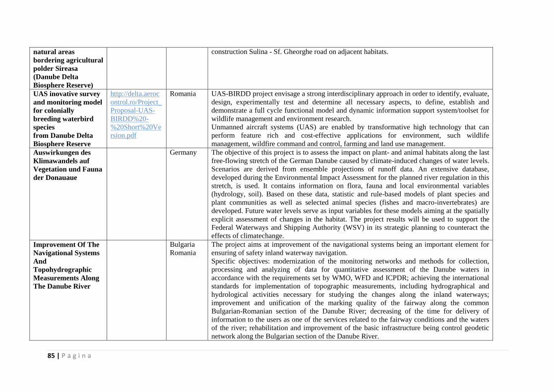
85 | P a g i n a
natural areas
bordering agricultural
polder Sireasa
(Danube Delta
Biosphere Reserve)
construction Sulina - Sf. Gheorghe road on adjacent habitats.
UAS inovative survey
and monitoring model
for colonially
breeding waterbird
species
from Danube Delta
Biosphere Reserve
http://delta.aeroc
ontrol.ro/Project_
Proposal-UAS-
BIRDD%20-
%20Short%20Ve
rsion.pdf
Romania UAS-BIRDD project envisage a strong interdisciplinary approach in order to identify, evaluate,
design, experimentally test and determine all necessary aspects, to define, establish and
demonstrate a full cycle functional model and dynamic information support system/toolset for
wildlife management and environment research.
Unmanned aircraft systems (UAS) are enabled by transformative high technology that can
perform feature rich and cost-effective applications for environment, such wildlife
management, wildfire command and control, farming and land use management.
Auswirkungen des
Klimawandels auf
Vegetation und Fauna
der Donauaue
Germany The objective of this project is to assess the impact on plant- and animal habitats along the last
free-flowing stretch of the German Danube caused by climate-induced changes of water levels.
Scenarios are derived from ensemble projections of runoff data. An extensive database,
developed during the Environmental Impact Assessment for the planned river regulation in this
stretch, is used. It contains information on flora, fauna and local environmental variables
(hydrology, soil). Based on these data, statistic and rule-based models of plant species and
plant communities as well as selected animal species (fishes and macro-invertebrates) are
developed. Future water levels serve as input variables for these models aiming at the spatially
explicit assessment of changes in the habitat. The project results will be used to support the
Federal Waterways and Shipping Authority (WSV) in its strategic planning to counteract the
effects of climatechange.
Improvement Of The
Navigational Systems
And
Topohydrographic
Measurements Along
The Danube River
Bulgaria
Romania
The project aims at improvement of the navigational systems being an important element for
ensuring of safety inland waterway navigation.
Specific objectives: modernization of the monitoring networks and methods for collection,
processing and analyzing of data for quantitative assessment of the Danube waters in
accordance with the requirements set by WMO, WFD and ICPDR; achieving the international
standards for implementation of topographic measurements, including hydrographical and
hydrological activities necessary for studying the changes along the inland waterways;
improvement and unification of the marking quality of the fairway along the common
Bulgarian-Romanian section of the Danube River; decreasing of the time for delivery of
information to the users as one of the services related to the fairway conditions and the waters
of the river; rehabilitation and improvement of the basic infrastructure being control geodetic
network along the Bulgarian section of the Danube River.
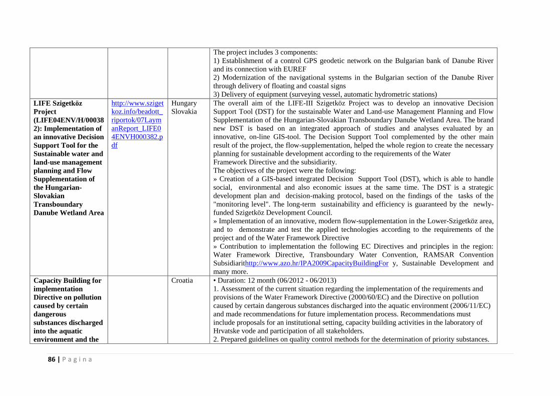
86 | P a g i n a
The project includes 3 components:
1) Establishment of a control GPS geodetic network on the Bulgarian bank of Danube River
and its connection with EUREF
2) Modernization of the navigational systems in the Bulgarian section of the Danube River
through delivery of floating and coastal signs
3) Delivery of equipment (surveying vessel, automatic hydrometric stations)
LIFE Szigetköz
Project
(LIFE04ENV/H/00038
2): Implementation of
an innovative Decision
Support Tool for the
Sustainable water and
land-use management
planning and Flow
Supplementation of
the Hungarian-
Slovakian
Transboundary
Danube Wetland Area
http://www.sziget
koz.info/beadott_
riportok/07Laym
anReport_LIFE0
4ENVH000382.p
df
Hungary
Slovakia
The overall aim of the LIFE-III Szigetköz Project was to develop an innovative Decision
Support Tool (DST) for the sustainable Water and Land-use Management Planning and Flow
Supplementation of the Hungarian-Slovakian Transboundary Danube Wetland Area. The brand
new DST is based on an integrated approach of studies and analyses evaluated by an
innovative, on-line GIS-tool. The Decision Support Tool complemented by the other main
result of the project, the flow-supplementation, helped the whole region to create the necessary
planning for sustainable development according to the requirements of the Water
Framework Directive and the subsidiarity.
The objectives of the project were the following:
» Creation of a GIS-based integrated Decision Support Tool (DST), which is able to handle
social, environmental and also economic issues at the same time. The DST is a strategic
development plan and decision-making protocol, based on the findings of the tasks of the
"monitoring level". The long-term sustainability and efficiency is guaranteed by the newly-
funded Szigetköz Development Council.
» Implementation of an innovative, modern flow-supplementation in the Lower-Szigetköz area,
and to demonstrate and test the applied technologies according to the requirements of the
project and of the Water Framework Directive
» Contribution to implementation the following EC Directives and principles in the region:
Water Framework Directive, Transboundary Water Convention, RAMSAR Convention
Subsidiarithttp://www.azo.hr/IPA2009CapacityBuildingFor y, Sustainable Development and
many more.
Capacity Building for
implementation
Directive on pollution
caused by certain
dangerous
substances discharged
into the aquatic
environment and the
Croatia • Duration: 12 month (06/2012 - 06/2013)
1. Assessment of the current situation regarding the implementation of the requirements and
provisions of the Water Framework Directive (2000/60/EC) and the Directive on pollution
caused by certain dangerous substances discharged into the aquatic environment (2006/11/EC)
and made recommendations for future implementation process. Recommendations must
include proposals for an institutional setting, capacity building activities in the laboratory of
Hrvatske vode and participation of all stakeholders.
2. Prepared guidelines on quality control methods for the determination of priority substances.
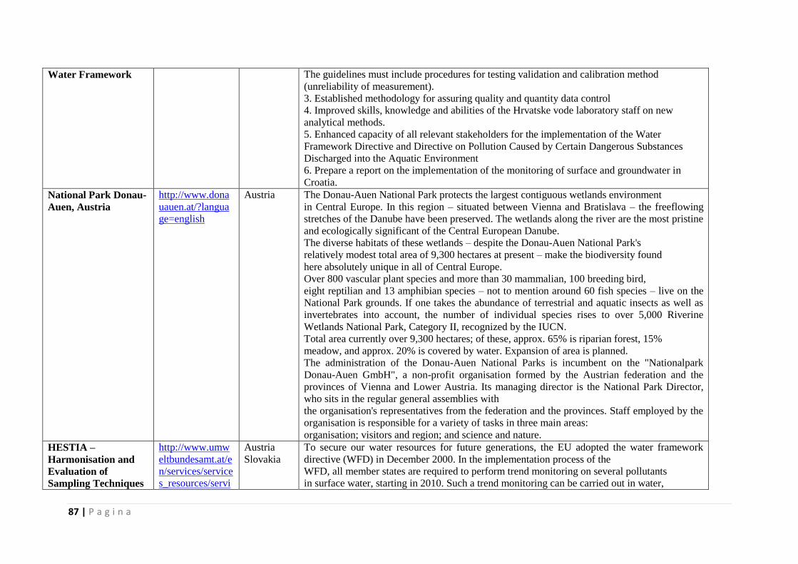
87 | P a g i n a
Water Framework The guidelines must include procedures for testing validation and calibration method
(unreliability of measurement).
3. Established methodology for assuring quality and quantity data control
4. Improved skills, knowledge and abilities of the Hrvatske vode laboratory staff on new
analytical methods.
5. Enhanced capacity of all relevant stakeholders for the implementation of the Water
Framework Directive and Directive on Pollution Caused by Certain Dangerous Substances
Discharged into the Aquatic Environment
6. Prepare a report on the implementation of the monitoring of surface and groundwater in
Croatia.
National Park Donau-
Auen, Austria
http://www.dona
uauen.at/?langua
ge=english
Austria The Donau-Auen National Park protects the largest contiguous wetlands environment
in Central Europe. In this region – situated between Vienna and Bratislava – the freeflowing
stretches of the Danube have been preserved. The wetlands along the river are the most pristine
and ecologically significant of the Central European Danube.
The diverse habitats of these wetlands – despite the Donau-Auen National Park's
relatively modest total area of 9,300 hectares at present – make the biodiversity found
here absolutely unique in all of Central Europe.
Over 800 vascular plant species and more than 30 mammalian, 100 breeding bird,
eight reptilian and 13 amphibian species – not to mention around 60 fish species – live on the
National Park grounds. If one takes the abundance of terrestrial and aquatic insects as well as
invertebrates into account, the number of individual species rises to over 5,000 Riverine
Wetlands National Park, Category II, recognized by the IUCN.
Total area currently over 9,300 hectares; of these, approx. 65% is riparian forest, 15%
meadow, and approx. 20% is covered by water. Expansion of area is planned.
The administration of the Donau-Auen National Parks is incumbent on the "Nationalpark
Donau-Auen GmbH", a non-profit organisation formed by the Austrian federation and the
provinces of Vienna and Lower Austria. Its managing director is the National Park Director,
who sits in the regular general assemblies with
the organisation's representatives from the federation and the provinces. Staff employed by the
organisation is responsible for a variety of tasks in three main areas:
organisation; visitors and region; and science and nature.
HESTIA –
Harmonisation and
Evaluation of
Sampling Techniques
http://www.umw
eltbundesamt.at/e
n/services/service
s_resources/servi
Austria
Slovakia
To secure our water resources for future generations, the EU adopted the water framework
directive (WFD) in December 2000. In the implementation process of the
WFD, all member states are required to perform trend monitoring on several pollutants
in surface water, starting in 2010. Such a trend monitoring can be carried out in water,
88 | P a g i n a
in the Aquatic
Environment
ces_water/?id=15
552
suspended particles and sediments as well as in biota. The decision which matrix to
survey is even more difficult for less water-soluble pollutants like polycyclic aromatic
hydrocarbons (PAH) and heavy metals. For those there is no generally accepted method
established within the EU.
The objective of our project HESTIA was therefore to compare different monitoring
methods for those pollutants (PAH, selected heavy metals) to give a technical
recommendation on how to perform a trend monitoring in the aquatic environment.
MoRe - The Morava
River Restoration
http://www.etc-
more.eu/ms/etc_
more/more_en/en
_theproject/
Austria
Slovakia
The project area extends from the confluence of the Morava and Thaya river km 69.00 to the
village Sierndorf at river km 53.0. The revitalization of this section is based on a joint
Austrian-Slovak Action Plan, which was for the entire cross-border route of the Morava River
within the project bgmII created. The main objectives are to restore the original character of the
meandering lowland river, to achieve a dynamic equilibrium according to the ecosystem
approach and to improve the diversity of natural habitats in the floodplains. These aims are
achieved through the gradual restoration of the natural interaction between the river bed and
flood plain that are currently isolated from each other. The project objectives are in line with
the requirements of the EU Water Framework Directive (achievement of good ecological
status) to promote as well the favourable conservation status under the EU-Fauna-Flora-Habitat
Directive and support the objectives of the trilateral Ramsar-site "March-Thaya-Auen".
OrientGATE - a
structured network
for integration of
climate knowledge
into policy and
planning
http://www.orient
gateproject.org/in
dex.php?page=pa
rtnership
Austria
Bulgaria
Croatia
Hungary
Romania
Serbia
Ukraine
The OrientGate project aims to coordinate climate change adaptation efforts in SEE countries
by building a lasting partnership between communities that produce knowledge and
experimental studies, and communities that apply that knowledge.
The project will:
develop a comprehensive and consistent methodology for assessing the risks arising as
a result of climate variability and change;
harmonise risk assessment and communication on the part of hydrometeorological
services;
encourage the use of acquired climate adaptation knowledge and experience in
territorial planning and development; and
enhance capacity to reconcile the risks and opportunities inherent in environmental
changes, including rising temperatures.
The core output to be developed by OrientGate is a set of web tools, designed to provide access
to data and metadata from climate observations and simulations that will be available through a
data platform connected to the European Climate Adaptation Platform (CLIMATE-ADAPT).
Other project outputs will include six pilot studies of specific climate adaptation exercises
developed by the project’s three thematic centres; capacity-building seminars and workshops;
89 | P a g i n a
and a working partnership among the hydrometeorological services of SEE countries. The
web-based network will make all project data, documentation, discussions and guidelines
accessible not only to the project partners but also to all interested SEE territories not directly
involved in the project.
Development of flood
hazard maps and
flood risk maps
Croatia The purpose of this project is to implement requirements of the EU Floods Directive
and to that end to prepare flood hazard maps and flood risk maps in the Republic of
Croatia.
This twinning project will focus on the second phase of the Floods Directive and will
help in the preparation of flood hazard maps and flood risk maps for selected pilot
areas as well as on preparation of guidance documents and capacity building of relevant
institutions. The results of this twinning project will be of great help to Croatian experts for the
upcoming third phase of the Floods Directive – the preparation of flood risk management
plans.
This Twinning is between Croatia and three EU Member States, the Netherlands,
Austria and France.
Water shortage
hazard and adaptive
water management
strategies in the
Hungarian-
Serbian cross-border
region
http://wahastrat.v
izugy.hu/
Hungary
Serbia
Hungary, as a member of the EU is engaged to fulfil the requirements of the EU Water
Framework Directive. Serbia, being a state heading towards the EU has also a great interest to
meet the requirements of the document. To achieve the goals of the directive, catchment
management plans need to be implemented, which provide a framework for major water
related issues. However, the management of future extremities and hydro-climatic hazards,
along with their more and more severe consequences, require an even more integrated
approach. Conflicts related to water shortage must be treated in a complex way by resolving
the opposing interests of different stakeholders (environmental protection, irrigation, industrial
use). The project therefore aims to find integrated water management solutions for the
increasing problem of water shortage. Catchments and water related problems are not related to
administrative boundaries, thus any measures in this field require a strong cross-border co-
operation.
Sustainable Transport
and Tourism along
the Danube
http://www.danu
becc.org/upl/TR
ANSDANUBE_l
eaflet_EN.pdf
Austria
Bulgaria
Germany
Hungary
Romania
Serbia
Slovakia
The Danube is passing 10 countries on its way to the Black Sea. Therefore it is one of the most
transnational rivers in the world. It is a river full of history and an important interlink between
the regions of South East Europe. Several initiatives clearly identified the need for cooperation
to boost the development of the Danube region. With the endorsement of the EU Strategy for
the Danube Region in April 2011, the member states declared their will for common action. In
line with the objectives of the South East Europe (SEE) Program, Transdanube is aiming at
tackeling the weak accessibility levels and poor quality of transport services in SEE as a major
constraint for further economic development and growth in the region. It is the objective of the
90 | P a g i n a
project to develop Sustainable Mobility along the Danube including environmentally friendly
modes of transport in order to improve the accessibility and facilitate the concept of sustainable
tourism in the whole Danube region. The regions will benefit from increased added value from
tourists being able to reach touristic destinations even in the hinterland of the river. The
development of sustainable transport offers will stimulate the shift to environmentally friendly
mobility systems resulting in reduced green house gas emissions/pollutants/noise and better
transport services for the inhabitants as well. This will finally influence the quality of the whole
region for economic development and the quality of life for the inhabitants themselves. In
order to reach the set objectives, Transdanube is following an intersectoral approach combining
the transport and the tourism sector, where the level of cooperation is still weak at the moment.
Based on an analysis of the state of the art of sustainable transport offers and tourism the
partners will develop actions plans resulting in a priorisation of possible solutions necessary to
overcome the identified gaps. A commonly defined vision for Soft Mobility developed and
agreed by the project partners will be the guideline for the development of sustainable transport
offers. Depending on the project partners? current stage in the planning process, activities will
include the elaboration of feasibility studies, pre-investment studies and demonstrations for the
implementation of new/ improved multimodal transport offers, new shipping services and
new/improved bicycle routes/services. As information about different available mobility
options is crucial for the usage of existing and/or newly developed transport offers, access to
this information has to be provided on different levels. The involvement of regional/ national
and transnational stakeholders is of major importance for the success of the project. Workshops
on the regional/national level as well as the participation in transnational conferences and
project meetings will provide adequate forums to inform relevant stakeholders about the
project and to get access to their know-how during the development and implementation of
specific sustainable mobility solutions. The main outputs and results will be: Transnational
State of the Art Report on sustainable mobility in the Danube region; Commonly developed
vision of Soft Mobility; regional action plans; precise sustainable transport offers; digital maps
presenting information about existing mobility- and tourism offers; Soft Mobility packages and
marketing plans.
With 14 financing partners allocated equally along the Danube and a large board on strategic
partner observers from all levels, the project outputs will reflect the situation
of sustainalbe mobility and tourism in this whole area. Summing up the expriences gained
during action implementation in reports and manuals will proof and facilitate the reproducible
character of the developed solutions. Therefore, Transdanube will support the promotion of
sustainalbe mobility as an environmentally friendly possibility to improve the accessibility in
91 | P a g i n a
the SEE region.
During the two years of the project’s implementation the following activities will be carried
out:
Transnational state-of-the-art report on sustainable mobility in the Danube region
(including good practice collection)
Common soft mobility vision
Regional action plans
Sustainable transport offers => Soft mobility tourism packages
Digital map, presenting information about existing mobility and tourist offers
Regional marketing plans and specific marketing activities
Sustainable spatial
development of
Danube area in Serbia
Serbia
The subject of the Project is the formation of a conceptual basis for an integral and balanced
spatial development of Danube area in Serbia. The key determinants of the development in the
EU Danubian countries are aimed at an integrated development of regions and local
communities in the coastal zone. The impact of the international
development documents on the Danube Area will be especially analyzed, as Serbia’s priority
within the transport, economic, cultural and other forms of integration into the EU. The
potential, limitations and manners of solving conflicts in the spatial development of the Danube
Area will be examined and analyzed, from the aspect of the impact of transport corridor VII,
water supply, tourism, mining, energy supply, industry etc, on the sustainable exploitation of
natural and cultural areas. Realizing the methods and determining the instruments for
overcoming high concentration of population and economy and development conflicts is one of
the greatest priorities of
this Project, especially from the aspect of directing rural development and rational use of space
in settlements, the protection of natural areas and cultural heritage. Activating the potentials of
Danube Area in Serbia is conditioned by the affirmation of strategic planning and the
development of a system of indicators (GIS) for efficient management of sustainable
development and integral environmental protection.
SEERISK - Joint
Disaster Management
risk assessment and
preparedness in the
Danube macroregion
http://www.seeris
kproject.eu/seeris
k/#main
Austria
Bulgaria
Hungary
Romania
Serbia
Slovakia
As a general trend in the SEE region, the frequency and seriousness of extreme climatic events
is increasing due to climate change. Even though climate change affects countries, territories
and localities differently, there are common and typical challenges. SEERISK takes into
account specific risks and horizontal challenges as well. The countries involved are territorially
coherent: the project concentrates on the Middle and Lower Danube Basin, where a wide range
of risk types occur. There are localities where flashflood is the predominant risk factor (e.g. in
Srbac), whereas in other project territories, unforeseeable thunderstorms cause serious damages
(e.g. to tourism in Siófok) or frequent draughts cause damage to agriculture. Low level of

92 | P a g i n a
awareness (addressed via risk assessment), week preparedness (to be addressed through better
information flow, awareness raising, cooperation) and institutional gaps (to be addressed by
institutional analysis) and weak territorial planning are common, horizontal challenges in those
regions.
Objectives of the project
to formulate common methodology for the assessment of natural hazards,
reveal the similarities and distinctions between the institutional framework of risk
assessment and disaster management
put in local practice the European Commission risk assessment guidelines
reveal the gap between risk experts and communities’ understanding of climate change
close gap between risk exposure and preparedness.
SEE RIVER -
Sustainable
Integrated
Management of
International River
Corridors in SEE
Countries
http://www.see-
river.net/results.h
tml
Austria
Croatia
Hungary
Romania
Serbia
Slovakia
Rivers in SEE region are often threatened by unsustainable use, increasing human pressure,
and problems of increased floods and droughts driven by climate change.
Inhabitation of floodplain areas, hydropower utilization, navigation, gravel and sand extraction,
unsustainable tourism etc. lead to changes in morphology, increased pollution, degradation of
aquatic habitats, as well as land use conflicts. The most pressures in a river basin occur along
river corridors, challenging the sustainable water and riparian land use. The common EU
legislation, in particular the Water Framework Directive, the Flood Directive, the Habitat
Directive, the Birds Directive and the Renewable Resources Directive, gives a framework to
develop processes and practices for sustainable river management. However, such sectoral
objectives are often antagonistic and provide a challenge for river managing authorities when it
comes to the implementation phase. The main objective of the SEE RIVER project is
to empower the multi-sectoral stakeholders sharing the territory of an international river
corridor to gain knowledge on planning and implementing processes for integration of existing
sectoral policies, plans and programmes in order to reach consensus on integrative
management of international river corridors, taking into account both the development and the
conservation interests. This will be achieved by developing the SEE RIVER Toolkit - a joint
approach for establishing common frameworks for integrative management of international
river corridors in SEE. Such framework will be established for the Drava River and initiated on
5 other SEE rivers: Bodrog, Prut, Soca, Neretva and Vjosa rivers. The River Frameworks will
use a cross-sectoral participatory approach to reach consensus among international
stakeholders on the joint vision, goals and measures for sustainable management of river
corridors. The project added value is that it does not aim at preparing new sectoral management
plans, nor invent new costly managing structures to improve the management of river
corridors. It rather provides a framework for utilising the existing management structures and
93 | P a g i n a
sectoral policies, plans and programmes. The project aim is to simplify and rationalise the
procedures for reaching synergetic solutions between development and conservation interests
of stakeholders along international river corridors. Through application of the Toolkit and the
Frameworks on 6 SEE Rivers the project will improve the transboundary and multi-sectoral
cooperation of existing bodies responsible for the management of river corridors in 14 SEE
countries. This will increase the capacities and skills for consensus building among policy
making and implementing bodies from different sectors in SEE. This way the project will
improve policy making processes which we believe is the only way to long term improvement
of the quality of life along the river corridors and in the wider SEE region.
SEEMAriner -South
Eastern Europe
Marine and River
Integrated System for
Monitoring the
Transportation of
Dangerous Goods
www.seemariner
.eu/
http://www.delm
ne.ec.europa.eu/c
ode/navigate.php
?Id=2221&projec
t_id=180
Austria
Bulgaria
Croatia
Rep. of
Moldavia
Romania
Serbia
Slovakia
Ukraine
The SEE area is a sea and river transit space of vessels carrying hazardous freight which
constitutes many potential environmental risks for coasts and inland waterways.
Economic development and a strong growth of transport and increased traffic in the SEE area
aggravate the already increased threats of pollution and thus there is a great need for efficient
management and for high performance observation, communication and monitoring response
systems.
Results:
Improved coordination, harmonisation and availability of data on the transportation of
dangerous cargoes;
Enhanced managerial skills and equipment for handling dangerous cargoes;
Developed and tested common management structures and tools for the monitoring of
dangerous goods transportation;
Streamlined procedures and protocols for emergency situations or disasters caused by
the transportation of dangerous goods.
SEE HYDROPOWER
- targeted to improve
water resource
management for a
growing
renewable energy
production
http://www.seehy
dropower.eu/
Austria
Rep. of
Moldova
Romania
Hydropower is the most important renewable resource for energy production in the SEE
countries but creates ecological impacts on a local scale. If on one hand, hydroelectric
production has to be maintained and likely increased following the demand trend and RES-e
Directive, on the other hand, hydropower utilisation often involves severe hydrological
changes, damages the connectivity of water bodies and injures river ecosystems. The project
gives a strong contribution to the integration between the Water Frame and the RES-e
Directives in the involved countries.
Sava river basin:
sustainable use,
management and
protection of
resources
http://wbc-
inco.net/object/pr
oject/8016
Croatia
Serbia
The Sava River (945 km) is the biggest tributary to the Danube River and has 95551 km2 large
catchment. It extends over four countries, Slovenia, Croatia, Bosnia and Herzegovina and
Serbia and Montenegro. In the development of the river basin management plan all countries
are already collaborating under the International Commission for the Protection of the Danube
River (ICPDR) guidance. Until 1991, the methodological bases for data collection have been
94 | P a g i n a
reasonably unified over the catchment, but lucking a lot of today's important aspects such are
ecological character of the river and its tributaries, inventory of pollution sources, dangerous
substances, socio-economic parameters, cost and benefit implications and similar. For the later
period a lot of data a re missing due to insufficient monitoring (financing, recent warfare) and
weak institutional and legal control over use of water and land resources of the Sava River
catchment. Many aspects of the river quality need scientific investigations. Furthermore, there
is a need to link the knowledge of river quality state and environmental and health risk with
pressures and their driving forces to propose efficient and beneficiary actions and measures for
protection. In the project specific tools based on combined ion of chemical analysis and
biological effect methods will be developed and validated for the pollution of sediments and
impact on water biota. Geographical distribution of pollution will be identified and historical
trends defined. Integrated prediction model about the behaviour of hazardous chemical
substances will be integrated with the socio-economic prediction model to serve as a base for
the elaboration of scenario, remediation measures and best practice techniques. For that
purpose an expert data an d information management system will be developed.
It ended in 2007.
Protecting Rivers
from Accidental
Industrial Pollution
http://territorialco
operation.eu/front
page/show/360
Bulgaria
Hungary
Although the general condition of most European rivers has improved over recent years,
accidental spills of chemicals in rivers remain a severe threat to the environment. This risk is
characteristic of all regions involved in the RIVER SHIELD project, as the areas are crossed by
rivers which flow through more than one country, such as the Danube, Oder, Strimon and
Nestos. To overcome the problem of accidental industrial pollution a close co-operation of all
involved authorities, services and organisations from all countries concerned is necessary.
River Shield targets the protection of rivers from pollution caused by industrial accidents
through development and implementation of risk management, prevention and response good
practices.
The project partners are public authorities and environmental protection organisations from
Greece, Hungary, Poland, the Czech Republic, Slovenia and Bulgaria. River Shield increases
the capacity of the involved environmental protection and emergency response services to
minimise the impact of potential industrial accidents. Regional Networks will be formed to
strengthen know-how exchange and transnational co-operation. Emergency response guides
will be compiled and disseminated. Spatial planning and land-use measures and policies will be
developed and proposed. As a supportive mechanism, the River Shield Unit for the future
utilisation of the project outcomes will be institutionalised. Dissemination actions will be
carried out at regional, national and European level.
Risk mapping studies Romania The project’s partnership is the core of a research network whose activity aims to develop
95 | P a g i n a
and planning.
Providing a digital
terrain model for risk
management
in the Lower Danube
(RISKGAL)
monitoring and analysis of risk factors in the Lower Danube, at a level of excellence according
to international norms. The project covers three types of natural hazards (earthquakes,
landslides and floods), only seismic hazard is unpredictable and unforeseeable. Hazard / natural
risk maps should be defined in the county territory, by a multidisciplinary team specialized and
properly equipped. The project aims to develop further risk maps based on the elaborated
hazard maps, taking into account the vulnerability of the sites objectives. The natural hazard
maps will give high precision results in four dimensions, with an indefinite possibility of use in
time and space. The expert system developed from these maps will be on the hand of local
authorities for optimal, efficient and scientifically based decisions.
Past Projects EUWater -
Transnational
integrated
management of water
resources in
agriculture for the
EUropean
WATER emergency
control
http://www.eu-
water.eu/
Croatia
Hungary
Romania
Serbia
Ukraine
EU.WATER, carried out in 8 rural study areas belonging to 8 SEE Countries, tackles the
emergency related to water consumption and contamination in Europe, and aims at spreading,
at transnational level, integrated water resource management in agriculture based on the
optimization of water consumption and cutback of groundwater pollution.
Through a joint strategy and its downscaling within each Project Partner's governance
framework, EU.WATER (which starts from the capitalization of the extreme & fragmented
load of results of previous projects) moves towards (1) application of the EU Water and Nitrate
Directives across SEE Countries (2) development of adaptive-learning practices and innovative
solution to contribute at the transition of local agriculture towards innovative and
environmental-friendly measures (3) incentives to farmers to adopt eco-prescriptive practices.
EU.WATER, fostering the ongoing rural reforms and agricultural transformation process of
most of the SEE Countries (some of them approaching the EU entry), has the capacity to
positively influence the process for choosing agricultural management practices at the field
scale, where the application of environmental protection measures bring to A) the stewardship
of the natural resources B) the generation of incoming benefits in terms of crop’s productivity.
Ownership & capacity to achieve the expected results is ensured by the profile of PPs and by
the role assigned to stakeholders: combination of governance actors (at national, regional and
provincial scale) + high-professional technical institutions (as agro-environmental research
centres & universities) + permanent network of technicians, association and farmers (called
upon to contribute to the general strategy and to apply land-based practices) assure the reach of
objectives and the effective impact of the project in the local rural policies.
EU.WATER is scheduled to run from March 2009 to February 2012.
Water scenarios for
Europe and for
Neighbouring States
http://www.wise-
rtd.info/en/info/w
ater-scenarios-
Hungary
Romania
Ukraine
The SCENES project will develop and analyse a set of comprehensive scenarios of Europe's
freshwater futures up to 2025, covering all of Greater Europe reaching to the Caucasus and
Ural Mountains, and including the Mediterranean rim countries of north Africa and the near
96 | P a g i n a
(SCENES) europe-and-
neighbouring-
states
East. These scenarios will provide a reference point for long term strategic planning of
European water resource development, alert policymakers and stakeholders about emerging
problems, and allow river basin managers to test regional and local water plans against
uncertainties and surprises which are inherently imbedded in a longer term strategic planning
process.
Funding Programme: FP6
UNDP/GEF DRP -
Danube Regional
Project
http://aws.undp-
drp.org/drp/proje
ct
Bulgaria
Croatia
Hungary
Moldavia
Romania
Serbia
Slovakia
Ukraine
The main goal of the project is to strengthen existing structures and activities in order to
facilitate a regional approach, thus strengthening the capacity of the ICPDR and the Danube
countries to fulfill their legally binding commitment to implement the Danube Convention.
This task now also includes the development of a River Basin Management Plan in line with
the EU's Water Framework Directive.
The following project components are designed to respond to the overall development
objective:
Creation of sustainable ecological conditions for land use and water management;
Capacity building and reinforcement of transboundary cooperation for the
improvement of water quality and environmental standards in the Danube River Basin;
Strengthening of public involvement in environmental decision making and
reinforcement of community actions for pollution reduction and protection of
ecosystems;
Reinforcement of monitoring, evaluation and information systems to control
transboundary pollution, and to reduce nutrients and harmful substances.
Duration: 2001-2007
Defensive strategies
and cross border
policies. Integration of
the Lower Danube
area in
the Roman civilization
http://www.strate
g.org.ro/index-
en.html
Romania The project aims at developing an integrated IT system for the collection, analysis, valorisation
and elevation of the results of archaeological research in the Roman provinces covered by the
Romanian territory.
C OORDINATOR: National History Museum of Romania (MNIR)
PARTNERS:
Bucharest University (UB)
"Vasile Pârvan" Archaeology Institute (IAB)
Archaeology and Art History Institute (IAIAC)
SC Digital Domain SRL (DD)
The research supposes:
a) the field research phase - obtaining modern measurements (topographic, radar and GPS)
of the objectives targeted by the project, as well as their photographs.
b) data processing, that means: 1) assembling a maps, epigraphic, photographic,
97 | P a g i n a
bibliographic and topographic archive; 2) recording this archive on a digital format, accessible
on line
c) the analysis of the data obtained and the presentation of the results in specialized works on
a classic format and on line, in seminaries or optional courses at the Faculty of History
(Bucharest). Obtaining a series of ample analyses that will be published in the Centre's
monographic series.
Potential threats to
environmental and
economic
sustainability in the
Danube and Black
Sea region: Danube
River as invasive alien
species corridor
http://www.eseni
as.org/index.php?
option=com_cont
ent&view=article
&id=302:news-
10-danube-field-
trip-
&catid=52:esenia
s-
news&Itemid=12
5
Bulgaria
The main goal of the project is to analyse the role of the invasive alien species (qualitative and
quantitative parameters, impact, measures) for the sustainable development in the Danube and
the Black Sea region. To implement this goal, regular monitoring will be carried out, lists of
alien and invasive species, as well as pathways of their introduction, will be developed, data
about biology, ecology and impact will be collected. The results will be used for risk
assessment and development of risk management plan.
Tisza River Project
(EVK1-CT-2001-
00099); Real life scale
catchment models for
supporting water and
environmental
management decisions
http://www.wise-
rtd.info/en/info/ti
sza-river-project-
real-life-scale-
integrated-
catchment-
models-
supporting-water-
and
Hungary
Romania
Ukraine
End date of the project:
31/12/2004
Funding program:
FP5
Contract Code:
EVK1-CT-2001-00099
The Tisza river basin is of major concern from both water- and environmental management
points of view. This is also the international catchment where the catastrophic cyanide and
heavy metal pollution accidents happened.
The work in the Tisza-River project focussed on the development of a ‘real-life-scale’
catchments model for this river basin. In addition, eco-hydrological management strategies
were developed for the unique wetlands of the riparian zone of the river. Objective oriented
sets of hydrological, hydraulic, water quality and ecological models were developed to form an
integrated model system that meets the users’ requirements.
UNIVERSITIES, INSTITUTES AND LABORATORIES
98 | P a g i n a
Universität für
Bodenkultur Wien
(BOKU)
http://www.boku.
ac.at/en/
Austria The University of Natural Resources and Life Sciences, the Alma Mater Viridis, perceives
itself as a teaching and research centre for renewable resources, which are necessary for human
life.
Topics: Forestry and Wood Science, Water Management, Agriculture, Food Chemistry and
Biotechnology, Natural Resources Management and Ecological Engineering, Landscape
Design and Landscape Planning, Environment and Bio-Resources Management.
The university offers BSc and PhD programmes and Master studies in English.
Centre for Global
Change and
Sustainability-
University of Natural
Resources and Life
Sciences, BOKU
http://www.boku.
ac.at/
Austria The Centre for Global Change and Sustainability supports the University of Natural Resources
and Life Sciences in realizing its societal responsibility; provides impetus for ideas regarding
topics of global change and sustainable development.
The Centre is a place of interdisciplinary, scientific debate and offers a learning environment
for complex relationships and innovative ideas.
University of Vienna,
Faculty of Earth
Sciences, Geography
and Astronomy;
Faculty of Chemistry;
Faculty of life sciences
http://www.univi
e.ac.at/en/univers
ity/
Austria The University of Vienna was founded by Duke Rudolph IV in 1365. It is the oldest university
in the German-speaking world and one of the largest in Central Europe. The University of
Vienna is the largest Austrian research institution. Approximately 6,900 academics guarantee
its outstanding performance in research and teaching. The 15 faculties and four centers are
dedicated to both basic and applied research.
Research Centre of
Hydraulic
Engineering -
Laboratory, TU
Vienna, Austria
http://www.kw.tu
wien.ac.at/en/rese
arch-center-of-
hydraulic-
engineering/labor
atory/service-
offer.html
Austria The present Institute of Hydraulic Engineering and Water Resources Management was
established as part of the then Vienna Polytechnic in the year 1818. Professor Schaffernak
setup a first Laboratory in the main building in 1926. Since 1995 the Institute has had a new
Hydraulic Laboratory at the Aspanggründe, Adolf-Blamauer Gasse 3, A-1030 Vienna.
The Laboratory consists of a main testing hall, an attached testing hall with 2 tilting flumes, an
office block and an open-air testing area with a canvas-protected zone.
Both testing halls are connected with the workshop and storage rooms for materials for model
production. Each location of the testing area can be independant supplied with water by means
of stationary or flexible pipes (present installed pump capacity is 2500 l/s). Additionally to
these laboratory facilities are a seminar room, several offices and auxiliary rooms in the
attached block.
The Laboratory has presently the following test facilities with the necessary infrastructure to
fulfill the requirements in teaching, experimental research and commercial testing.
•Testing halls with crane 1400 m²
•Open-air testing area 2000 m²
•2 tilting flumes each of length 17 m
99 | P a g i n a
•Flexible flumes
•Reservoir 1000 m³
•Capacity of pumps 2500 l/s
•Mechanical workshop with crane 300 m²
•Electronic laboratory 80 m²
•Offices and seminar room 300 m²
The performance of hydraulic model tests within internal but primarily external financed (from
private and public clients) research projects (fundamental and applied research as well) are
counted adjacent to teaching to the main activities of the Institute. These projects concern
mainly the following research fields:
River engineering (flood protection, sediment transport, navigation)
Ecological hydraulic engineering (restoration, bed stabilization, fish migration
facilities)
Hydraulic Structures (weirs, power stations, dams, spillways, intakes, outlets, power
conduits, gates, diversions, specific structures)
Duct systems (valves, manifolds, culverts etc.)
Cooling water systems (pumping stations) etc.
Embankment dams (slope protection - overtopping sections, dam-break flood analysis
- breach formation, design - constructive solutions
Christian Doppler
Laboratory -
Advanced methods in
river monitoring,
modelling and
engineering, Vienna,
Austria
https://forschung.
boku.ac.at/fis/suc
hen.projekt_uebe
rsicht?sprache_in
=en&menue_id_i
n=300&id_in=81
91
Austria Water forms the basis for life, on the other hand destroys life during extreme floods.
Rivers are the lifelines of the landscape, most human settlements are situated along these since
thousands of years, related to all possibilities of usage – including navigation, hydropower and
recreation - but also danger. These anthropogenic uses of rivers impact the ecological status, so
that conflicts increase between economic use and ecological functionality. The interrelation
between transport of water, sediments,
morphodynamics of rivers, ecology and the consequences of river engineering measures are
not fully understood and described. The Christian Doppler Laboratory for Advanced methods
in river monitoring, modelling and engineering aims to improve the understanding of processes
in rivers, to design mathematical models for simulating river processes and to predict the
consequences of engineering measures as well as to develop river engineering methods for
improving navigation, ecology and flood protection.
Laboratory
Module I - River Monitoring
New monitoring methods such as Acoustic Doppler Velocimetry, Radiotracer, Multibeam
Echosounder and shear stress plates will be combined, further developed and applied, in order
100 | P a g i n a
to improve the understanding of river processes, the calibration and validation of mathematical
models and monitoring programs and the optimisation for practical usage by UWITEC and via
Donau.
Module II - River Modelling
Multidimensional mathematical models will be planned and designed for simulating
hydrodynamics, sediment transport, river morphodynamics as well as ecological processes
through habitat modelling for later use in river engineering projects by via Donau. Thereby
data from Module 1 form the basis for model calibration and validation and the results enter
Module III.
Module III - River Engineering and Management
The development and implementation of advanced river engineering measures are based on
monitoring (Module I) and modelling (Module II) results and rely on an improved process
understanding. By the realization of the optimized measures via Donau will be contributing
significantly to the economic development along the Danube river as international waterway as
well as to the improvement of the ecological status.
Federal Environment
Agency
Austria(Umweltbunde
samt) Ecosystem
Monitoring
http://www.umw
eltbundesamt.at/
Austria Within the scope of environmental control, the Umweltbundesamt records, analyses and
evaluates data on the state and development of the environment in all areas. The main task of
Umweltbundesamt is primarily to support the environmental policy of the federal government.
The Umweltbundesamt is a sought-after partner of international organisations such as the EU
Commission, the European Environment Agency, UNEP, OECD and ECE.
Cooperation activities are aiming at the development of integrated and harmonised networks of
multi-functional long-term ecosystem research platforms to support interdisciplinary
investigation of long term processes related to the different components of biodiversity at
relevant spatial and temporal scales in Europe.
University of Sofia,
Faculty of Geology
and Geography;
Faculty of Chemistry
and Pharmacy;
Faculty of Biology
https://www.uni-
sofia.bg/index.ph
p/eng/the_univers
ity/faculties
Bulgaria Sofia University St. Kliment Ohridski is the first institution of higher education in Bulgaria.
The teaching staff includes a significant part of the best specialists in Bulgaria in all major
areas of sciences and humanities. Research is an integral part of the teaching process. It is fully
supported yet not conducted by the Rector’s administration. Research is a prerequisite for
keeping pace with the most recent developments in the respective areas for both the lecturers
and university structures – laboratories, faculties, etc.
The Institute of
Biodiversity and
Ecosystem Research
(IBER)
http://www.iber.b
as.bg/
Bulgaria IBER is focused on theoretical and applied aspects of ecology, biodiversity, environmental
conservation and sustainable use of biological resources studies and providing training in the
competencies fields.
Institute of http://www.io- Bulgaria The research activities of the Institute are in the field of marine physics, chemistry, geology
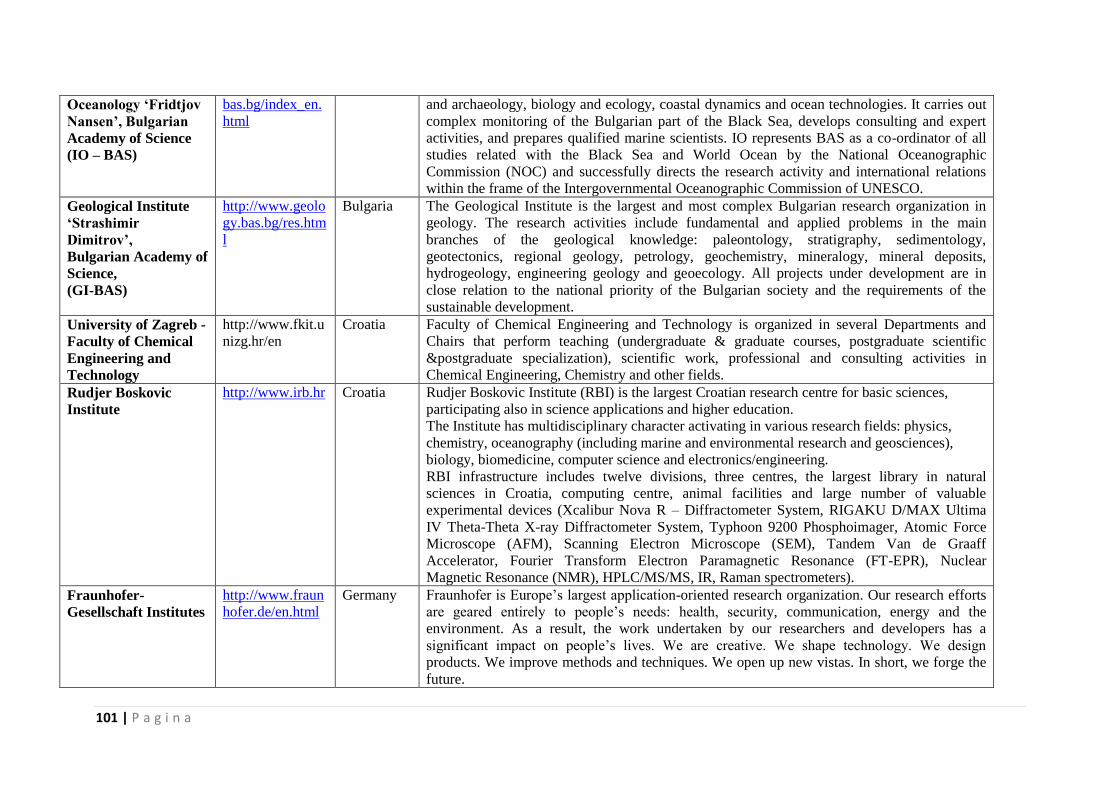
101 | P a g i n a
Oceanology ‘Fridtjov
Nansen’, Bulgarian
Academy of Science
(IO – BAS)
bas.bg/index_en.
html
and archaeology, biology and ecology, coastal dynamics and ocean technologies. It carries out
complex monitoring of the Bulgarian part of the Black Sea, develops consulting and expert
activities, and prepares qualified marine scientists. IO represents BAS as a co-ordinator of all
studies related with the Black Sea and World Ocean by the National Oceanographic
Commission (NOC) and successfully directs the research activity and international relations
within the frame of the Intergovernmental Oceanographic Commission of UNESCO.
Geological Institute
‘Strashimir
Dimitrov’,
Bulgarian Academy of
Science,
(GI-BAS)
http://www.geolo
gy.bas.bg/res.htm
l
Bulgaria The Geological Institute is the largest and most complex Bulgarian research organization in
geology. The research activities include fundamental and applied problems in the main
branches of the geological knowledge: paleontology, stratigraphy, sedimentology,
geotectonics, regional geology, petrology, geochemistry, mineralogy, mineral deposits,
hydrogeology, engineering geology and geoecology. All projects under development are in
close relation to the national priority of the Bulgarian society and the requirements of the
sustainable development.
University of Zagreb -
Faculty of Chemical
Engineering and
Technology
http://www.fkit.u
nizg.hr/en
Croatia Faculty of Chemical Engineering and Technology is organized in several Departments and
Chairs that perform teaching (undergraduate & graduate courses, postgraduate scientific
&postgraduate specialization), scientific work, professional and consulting activities in
Chemical Engineering, Chemistry and other fields.
Rudjer Boskovic
Institute
http://www.irb.hr Croatia Rudjer Boskovic Institute (RBI) is the largest Croatian research centre for basic sciences,
participating also in science applications and higher education.
The Institute has multidisciplinary character activating in various research fields: physics,
chemistry, oceanography (including marine and environmental research and geosciences),
biology, biomedicine, computer science and electronics/engineering.
RBI infrastructure includes twelve divisions, three centres, the largest library in natural
sciences in Croatia, computing centre, animal facilities and large number of valuable
experimental devices (Xcalibur Nova R – Diffractometer System, RIGAKU D/MAX Ultima
IV Theta-Theta X-ray Diffractometer System, Typhoon 9200 Phosphoimager, Atomic Force
Microscope (AFM), Scanning Electron Microscope (SEM), Tandem Van de Graaff
Accelerator, Fourier Transform Electron Paramagnetic Resonance (FT-EPR), Nuclear
Magnetic Resonance (NMR), HPLC/MS/MS, IR, Raman spectrometers).
Fraunhofer-
Gesellschaft Institutes
http://www.fraun
hofer.de/en.html
Germany Fraunhofer is Europe’s largest application-oriented research organization. Our research efforts
are geared entirely to people’s needs: health, security, communication, energy and the
environment. As a result, the work undertaken by our researchers and developers has a
significant impact on people’s lives. We are creative. We shape technology. We design
products. We improve methods and techniques. We open up new vistas. In short, we forge the
future.
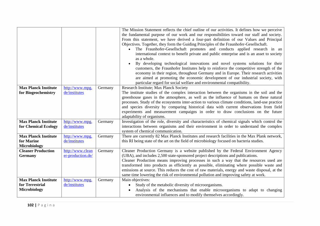
102 | P a g i n a
The Mission Statement reflects the chief outline of our activities. It defines how we perceive
the fundamental purpose of our work and our responsibilities toward our staff and society.
From this statement, we have derived a four-part definition of our Values and Principal
Objectives. Together, they form the Guiding Principles of the Fraunhofer-Gesellschaft.
The Fraunhofer-Gesellschaft promotes and conducts applied research in an
international context to benefit private and public enterprise and is an asset to society
as a whole.
By developing technological innovations and novel systems solutions for their
customers, the Fraunhofer Institutes help to reinforce the competitive strength of the
economy in their region, throughout Germany and in Europe. Their research activities
are aimed at promoting the economic development of our industrial society, with
particular regard for social welfare and environmental compatibility.
Max Planck Institute
for Biogeochemistry
http://www.mpg.
de/institutes
Germany Research Institute; Max Planck Society
The institute studies of the complex interaction between the organisms in the soil and the
greenhouse gases in the atmosphere, as well as the influence of humans on these natural
processes. Study of the ecosystems inter-action to various climate conditions, land-use practice
and species diversity by comparing historical data with current observations from field
experiments and measurement campaigns in order to draw conclusions on the future
adaptability of organisms.
Max Planck Institute
for Chemical Ecology
http://www.mpg.
de/institutes
Germany Investigation of the role, diversity and characteristics of chemical signals which control the
interactions between organisms and their environment in order to understand the complex
system of chemical communication.
Max Planck Institute
for Marine
Microbiology
http://www.mpg.
de/institutes
Germany There are currently 82 Max Planck Institutes and research facilities in the Max Plank network,
this RI being state of the art on the field of microbiology focused on bacteria studies.
Cleaner Production
Germany
http://www.clean
er-production.de/
Germany
Cleaner Production Germany is a website published by the Federal Environment Agency
(UBA), and includes 2,500 state-sponsored project descriptions and publications.
Cleaner Production means improving processes in such a way that the resources used are
transformed into products as efficiently as possible, eliminating where possible waste and
emissions at source. This reduces the cost of raw materials, energy and waste disposal, at the
same time lowering the risk of environmental pollution and improving safety at work.
Max Planck Institute
for Terrestrial
Microbiology
http://www.mpg.
de/institutes
Germany Main objectives:
Study of the metabolic diversity of microorganisms.
Analysis of the mechanisms that enable microorganisms to adapt to changing
environmental influences and to modify themselves accordingly.
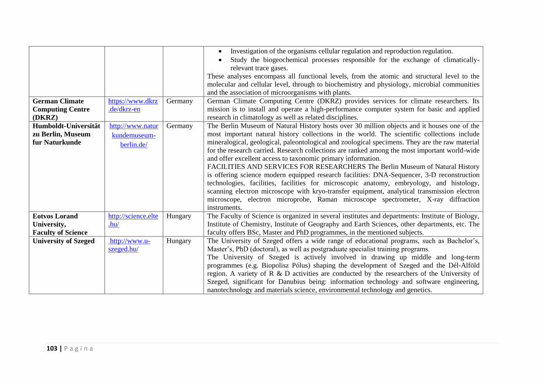
103 | P a g i n a
Investigation of the organisms cellular regulation and reproduction regulation.
Study the biogeochemical processes responsible for the exchange of climatically-
relevant trace gases.
These analyses encompass all functional levels, from the atomic and structural level to the
molecular and cellular level, through to biochemistry and physiology, microbial communities
and the association of microorganisms with plants.
German Climate
Computing Centre
(DKRZ)
https://www.dkrz
.de/dkrz-en
Germany German Climate Computing Centre (DKRZ) provides services for climate researchers. Its
mission is to install and operate a high-performance computer system for basic and applied
research in climatology as well as related disciplines.
Humboldt-Universität
zu Berlin, Museum
fur Naturkunde
http://www.natur
kundemuseum-
berlin.de/
Germany The Berlin Museum of Natural History hosts over 30 million objects and it houses one of the
most important natural history collections in the world. The scientific collections include
mineralogical, geological, paleontological and zoological specimens. They are the raw material
for the research carried. Research collections are ranked among the most important world-wide
and offer excellent access to taxonomic primary information.
FACILITIES AND SERVICES FOR RESEARCHERS The Berlin Museum of Natural History
is offering science modern equipped research facilities: DNA-Sequencer, 3-D reconstruction
technologies, facilities, facilities for microscopic anatomy, embryology, and histology,
scanning electron microscope with kryo-transfer equipment, analytical transmission electron
microscope, electron microprobe, Raman microscope spectrometer, X-ray diffraction
instruments.
Eotvos Lorand
University,
Faculty of Science
http://science.elte
.hu/
Hungary The Faculty of Science is organized in several institutes and departments: Institute of Biology,
Institute of Chemistry, Institute of Geography and Earth Sciences, other departments, etc. The
faculty offers BSc, Master and PhD programmes, in the mentioned subjects.
University of Szeged http://www.u-
szeged.hu/
Hungary The University of Szeged offers a wide range of educational programs, such as Bachelor’s,
Master’s, PhD (doctoral), as well as postgraduate specialist training programs.
The University of Szeged is actively involved in drawing up middle and long-term
programmes (e.g. Biopolisz Pólus) shaping the development of Szeged and the Dél-Alföld
region. A variety of R & D activities are conducted by the researchers of the University of
Szeged, significant for Danubius being: information technology and software engineering,
nanotechnology and materials science, environmental technology and genetics.
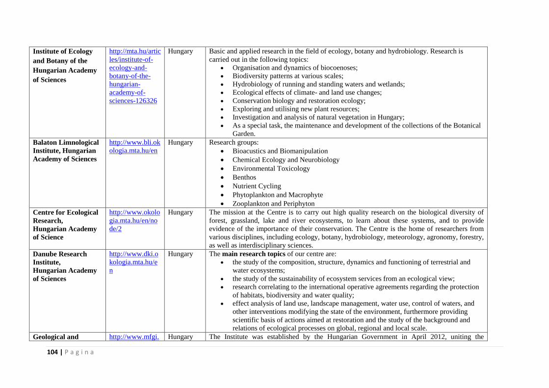
104 | P a g i n a
Institute of Ecology
and Botany of the
Hungarian Academy
of Sciences
http://mta.hu/artic
les/institute-of-
ecology-and-
botany-of-the-
hungarian-
academy-of-
sciences-126326
Hungary Basic and applied research in the field of ecology, botany and hydrobiology. Research is
carried out in the following topics:
Organisation and dynamics of biocoenoses;
Biodiversity patterns at various scales;
Hydrobiology of running and standing waters and wetlands;
Ecological effects of climate- and land use changes;
Conservation biology and restoration ecology;
Exploring and utilising new plant resources;
Investigation and analysis of natural vegetation in Hungary;
As a special task, the maintenance and development of the collections of the Botanical
Garden.
Balaton Limnological
Institute, Hungarian
Academy of Sciences
http://www.bli.ok
ologia.mta.hu/en
Hungary Research groups:
Bioacustics and Biomanipulation
Chemical Ecology and Neurobiology
Environmental Toxicology
Benthos
Nutrient Cycling
Phytoplankton and Macrophyte
Zooplankton and Periphyton
Centre for Ecological
Research,
Hungarian Academy
of Science
http://www.okolo
gia.mta.hu/en/no
de/2
Hungary The mission at the Centre is to carry out high quality research on the biological diversity of
forest, grassland, lake and river ecosystems, to learn about these systems, and to provide
evidence of the importance of their conservation. The Centre is the home of researchers from
various disciplines, including ecology, botany, hydrobiology, meteorology, agronomy, forestry,
as well as interdisciplinary sciences.
Danube Research
Institute,
Hungarian Academy
of Sciences
http://www.dki.o
kologia.mta.hu/e
n
Hungary The main research topics of our centre are:
the study of the composition, structure, dynamics and functioning of terrestrial and
water ecosystems;
the study of the sustainability of ecosystem services from an ecological view;
research correlating to the international operative agreements regarding the protection
of habitats, biodiversity and water quality;
effect analysis of land use, landscape management, water use, control of waters, and
other interventions modifying the state of the environment, furthermore providing
scientific basis of actions aimed at restoration and the study of the background and
relations of ecological processes on global, regional and local scale.
Geological and http://www.mfgi. Hungary The Institute was established by the Hungarian Government in April 2012, uniting the
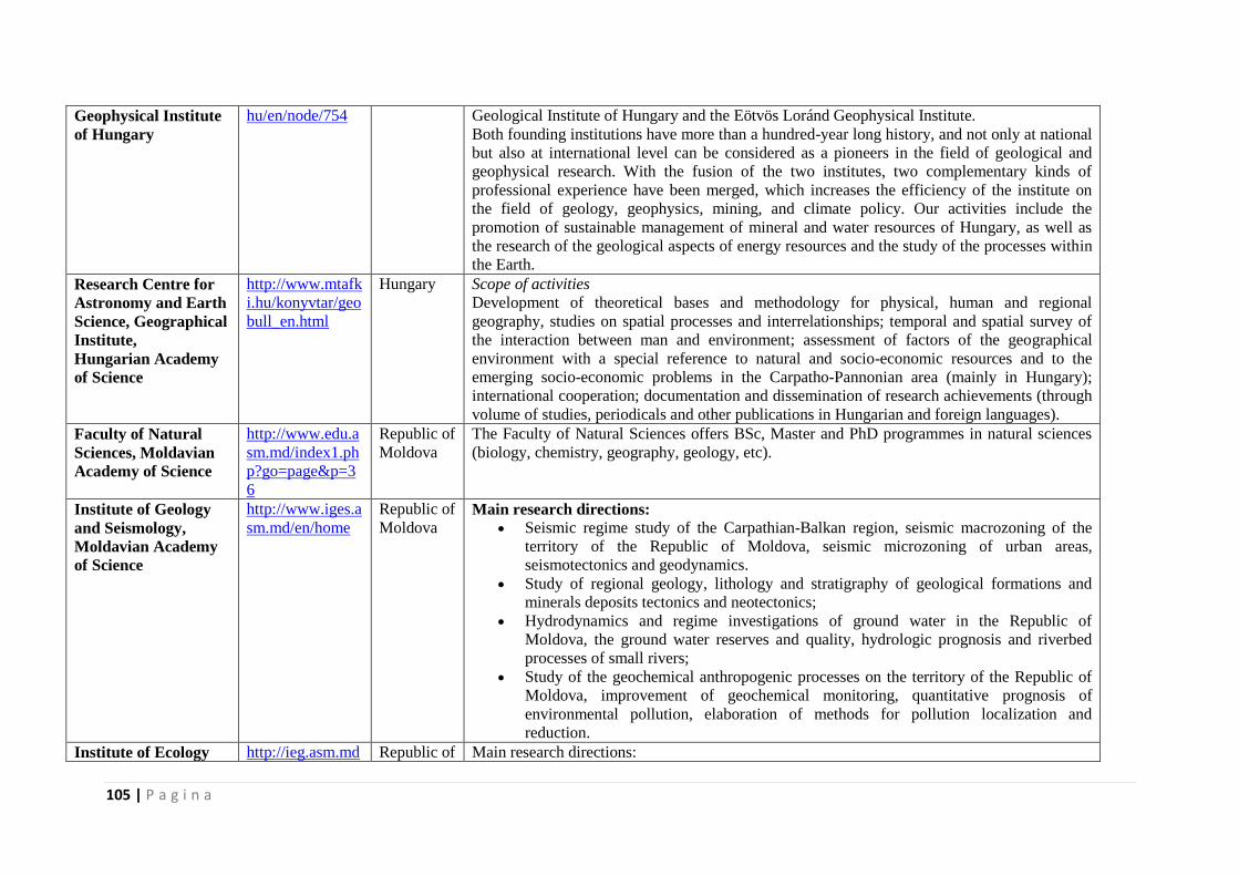
105 | P a g i n a
Geophysical Institute
of Hungary
hu/en/node/754 Geological Institute of Hungary and the Eötvös Loránd Geophysical Institute.
Both founding institutions have more than a hundred-year long history, and not only at national
but also at international level can be considered as a pioneers in the field of geological and
geophysical research. With the fusion of the two institutes, two complementary kinds of
professional experience have been merged, which increases the efficiency of the institute on
the field of geology, geophysics, mining, and climate policy. Our activities include the
promotion of sustainable management of mineral and water resources of Hungary, as well as
the research of the geological aspects of energy resources and the study of the processes within
the Earth.
Research Centre for
Astronomy and Earth
Science, Geographical
Institute,
Hungarian Academy
of Science
http://www.mtafk
i.hu/konyvtar/geo
bull_en.html
Hungary Scope of activities
Development of theoretical bases and methodology for physical, human and regional
geography, studies on spatial processes and interrelationships; temporal and spatial survey of
the interaction between man and environment; assessment of factors of the geographical
environment with a special reference to natural and socio-economic resources and to the
emerging socio-economic problems in the Carpatho-Pannonian area (mainly in Hungary);
international cooperation; documentation and dissemination of research achievements (through
volume of studies, periodicals and other publications in Hungarian and foreign languages).
Faculty of Natural
Sciences, Moldavian
Academy of Science
http://www.edu.a
sm.md/index1.ph
p?go=page&p=3
6
Republic of
Moldova
The Faculty of Natural Sciences offers BSc, Master and PhD programmes in natural sciences
(biology, chemistry, geography, geology, etc).
Institute of Geology
and Seismology,
Moldavian Academy
of Science
http://www.iges.a
sm.md/en/home
Republic of
Moldova Main research directions:
Seismic regime study of the Carpathian-Balkan region, seismic macrozoning of the
territory of the Republic of Moldova, seismic microzoning of urban areas,
seismotectonics and geodynamics.
Study of regional geology, lithology and stratigraphy of geological formations and
minerals deposits tectonics and neotectonics;
Hydrodynamics and regime investigations of ground water in the Republic of
Moldova, the ground water reserves and quality, hydrologic prognosis and riverbed
processes of small rivers;
Study of the geochemical anthropogenic processes on the territory of the Republic of
Moldova, improvement of geochemical monitoring, quantitative prognosis of
environmental pollution, elaboration of methods for pollution localization and
reduction.
Institute of Ecology http://ieg.asm.md Republic of Main research directions:
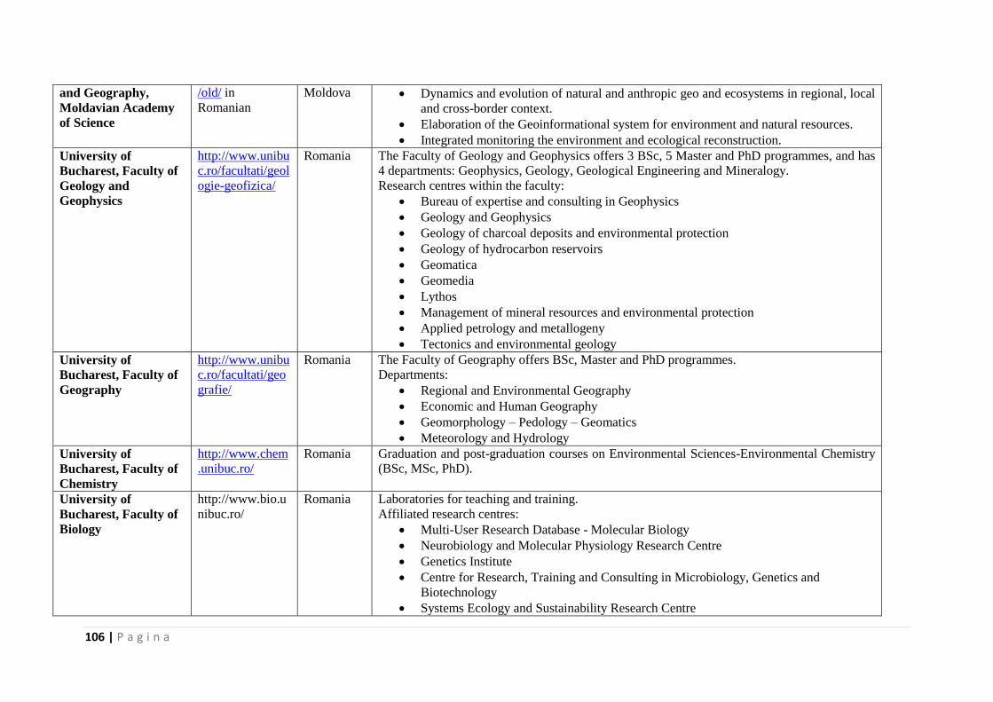
106 | P a g i n a
and Geography,
Moldavian Academy
of Science
/old/ in
Romanian
Moldova Dynamics and evolution of natural and anthropic geo and ecosystems in regional, local
and cross-border context.
Elaboration of the Geoinformational system for environment and natural resources.
Integrated monitoring the environment and ecological reconstruction.
University of
Bucharest, Faculty of
Geology and
Geophysics
http://www.unibu
c.ro/facultati/geol
ogie-geofizica/
Romania The Faculty of Geology and Geophysics offers 3 BSc, 5 Master and PhD programmes, and has
4 departments: Geophysics, Geology, Geological Engineering and Mineralogy.
Research centres within the faculty:
Bureau of expertise and consulting in Geophysics
Geology and Geophysics
Geology of charcoal deposits and environmental protection
Geology of hydrocarbon reservoirs
Geomatica
Geomedia
Lythos
Management of mineral resources and environmental protection
Applied petrology and metallogeny
Tectonics and environmental geology
University of
Bucharest, Faculty of
Geography
http://www.unibu
c.ro/facultati/geo
grafie/
Romania The Faculty of Geography offers BSc, Master and PhD programmes.
Departments:
Regional and Environmental Geography
Economic and Human Geography
Geomorphology – Pedology – Geomatics
Meteorology and Hydrology
University of
Bucharest, Faculty of
Chemistry
http://www.chem
.unibuc.ro/
Romania Graduation and post-graduation courses on Environmental Sciences-Environmental Chemistry
(BSc, MSc, PhD).
University of
Bucharest, Faculty of
Biology
http://www.bio.u
nibuc.ro/
Romania Laboratories for teaching and training.
Affiliated research centres:
Multi-User Research Database - Molecular Biology
Neurobiology and Molecular Physiology Research Centre
Genetics Institute
Centre for Research, Training and Consulting in Microbiology, Genetics and
Biotechnology
Systems Ecology and Sustainability Research Centre
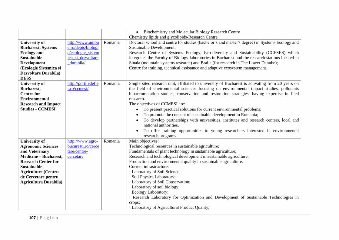
107 | P a g i n a
Biochemistry and Molecular Biology Research Centre
Chemistry lipids and glycolipids-Research Centre
University of
Bucharest, Systems
Ecology and
Sustainable
Development
(Ecologie Sistemica si
Dezvoltare Durabila)
DESS
http://www.unibu
c.ro/depts/biologi
e/ecologie_sistem
ica_si_dezvoltare
_durabila/
Romania Doctoral school and centre for studies (bachelor’s and master's degree) in Systems Ecology and
Sustainable Development;
Research Centre of Systems Ecology, Eco-diversity and Sustainability (CCESES) which
integrates the Faculty of Biology laboratories in Bucharest and the research stations located in
Sinaia (mountain systems research) and Braila (for research in The Lower Danube);
Centre for training, technical assistance and adaptive ecosystem management.
University of
Bucharest,
Centre for
Environmental
Research and Impact
Studies - CCMESI
http://portiledefie
r.ro/ccmesi/
Romania Single sited research unit, affiliated to university of Bucharest is activating from 20 years on
the field of environmental sciences focusing on environmental impact studies, pollutants
bioaccumulation studies, conservation and restoration strategies, having expertise in filed
research.
The objectives of CCMESI are:
To present practical solutions for current environmental problems;
To promote the concept of sustainable development in Romania;
To develop partnerships with universities, institutes and research centers, local and
national authorities,
To offer training opportunities to young researchers interested in environmental
research programs
University of
Agronomic Sciences
and Veterinary
Medicine – Bucharest,
Research Center for
Sustainable
Agriculture (Centru
de Cercetare pentru
Agricultura Durabila)
http://www.agro-
bucuresti.ro/cerce
tare/centre-
cercetare
Romania Main objectives:
Technological resources in sustainable agriculture;
Fundamentals of plant technology in sustainable agriculture;
Research and technological development in sustainable agriculture;
Production and environmental quality in sustainable agriculture.
Current infrastructure:
· Laboratory of Soil Science;
· Soil Physics Laboratory;
· Laboratory of Soil Conservation;
· Laboratory of soil biology;
· Ecology Laboratory;
· Research Laboratory for Optimization and Development of Sustainable Technologies in
crops;
· Laboratory of Agricultural Product Quality;
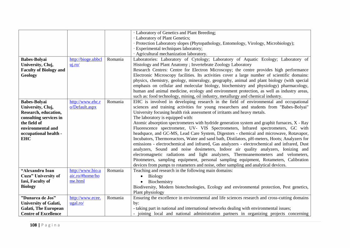
108 | P a g i n a
· Laboratory of Genetics and Plant Breeding;
· Laboratory of Plant Genetics;
· Protection Laboratory slopes (Phytopathology, Entomology, Virology, Microbiology);
· Experimental techniques laboratory;
· Agricultural mechanization laboratory.
Babes-Bolyai
University, Cluj,
Faculty of Biology and
Geology
http://bioge.ubbcl
uj.ro/
Romania Laboratories: Laboratory of Cytology; Laboratory of Aquatic Ecology; Laboratory of
Histology and Plant Anatomy ; Invertebrate Zoology Laboratory
Research Centres: Centre for Electron Microscopy; the centre provides high performance
Electronic Microscopy facilities. Its activities cover a large number of scientific domains:
physics, chemistry, geology, mineralogy, geography, animal and plant biology (with special
emphasis on cellular and molecular biology, biochemistry and physiology) pharmacology,
human and animal medicine, ecology and environment protection, as well as industry areas,
such as: food technology, mining, oil industry, metallurgy and chemical industry.
Babes-Bolyai
University, Cluj,
Research, education,
consulting services in
the field of
environmental and
occupational health -
EHC
http://www.ehc.r
o/Default.aspx
Romania EHC is involved in developing research in the field of environmental and occupational
sciences and training activities for young researchers and students from "Babes-Bolyai"
University focusing health risk assessment of irritants and heavy metals.
The laboratory is equipped with:
Atomic absorption spectrometers with hydride generation system and graphit furnaces, X - Ray
Fluorescence spectrometer, UV- VIS Spectrometers, Infrared spectrometers, GC with
headspace, and GC-MS, Lead Care System, Digestors - chemical and microwave, Rotavapor,
Incubators, Thermoreactors, Water and sand bath, Distilators, pH-meters, Hoots; Analyzers for
emissions - electrochemical and infrared, Gas analyzers - electrochemical and infrared, Dust
analyzers, Sound and noise dosimeters, Indoor air quality analyzers, Ionizing and
electromagnetic radiations and light analyzers, Thermoanemometers and velometers,
Pitotmeters, sampling equipment, personal sampling equipment, Rotameters, Calibration
devices from pumps to rotameters and noise, other sampling and analytical devices.
“Alexandru Ioan
Cuza” University of
Iasi, Faculty of
Biology
http://www.bio.u
aic.ro/#home/ho
me.html
Romania Teaching and research in the following main domains:
Biology
Biochemistry
Biodiversity, Modern biotechnologies, Ecology and environmental protection, Pest genetics,
Plant physiology
”Dunarea de Jos”
University of Galati,
Galati, The European
Centre of Excellence
http://www.ecee.
ugal.ro/
Romania Ensuring the excellence in environmental and life sciences research and cross-cutting domains
by:
- taking part in national and international networks dealing with environmental issues;
- joining local and national administration partners in organizing projects concerning
109 | P a g i n a
for the Environment -
ECEE
environmental protection, sustainable development and studies of the influence of
environmental factors on the population’s health;
-training specialists in various fields pertaining to the environment;
-providing consulting and expertise in a wide range of environmental issues;
-organizing students and teaching staff exchange, financially supported by international
institutions granting scholarships or by ECEE partners in international projects granting funds
from their budgets;
-organizing national and international conferences, seminars, work-shops on aspects directly or
indirectly connected with monitoring the environment, its quality and management.
ECEE is the only European centre of excellence in research from Romania included in the
International Network for Sustainable Management.
Ovidius University of
Constanta,
Centre for the Study
of Biological Diversity
http://www.stiint
ele-
naturii.ro/centrul-
de-documentare-
pentru-studiul-
biodiversitatii
Romania Main objectives:
Building and maintain a database on marine biodiversity and terrestrial biodiversity of
Dobrogea;
Studying the new invertebrate species from the Black Sea, their ecology and their
impact on native species and associations of organisms;
Monitoring of ecological status of protected areas in Dobrogea;
Working with local authorities, non-governmental organizations and the media to raise
awareness of the public about the problems posed by preserving biodiversity.
National Institute of
Research and
Development for
Biological Sciences-
NIRDBS
http://www.dbior
o.eu/
Romania The institute is a Center of excellence in life sciences, promoting fundamental and applicative
research in the field of life sciences by multidisciplinary research, from cellular and molecular
biology, biotechnology biodiversity, up to ensuring the appropriate consultancy, covering
scientific and socio-economic interests, equally involved in national and international
networking.
The head-quarter is established in Bucharest and has 2 branches: Institutes of Biological
Researches Cluj Napoca (ICB Cluj-Napoca) and Iaşi (ICB Iasi) and 1 subsidiary, Centre of
Biological Researches „Stejarul” Piatra Neamţ (CCB P. Neamt).
There are three main directions of activity: biomedical research (including cell and molecular
biology, tissue engineering, etc.), agriculture and food researches and biodiversity researches.
All these directions are sustained and correlated by a horizontal structure which consists in:
bioanalysis, bioinformatics, bioproducts and biotechnologies.
The National Institute
for Research and
Development of
Marine Geology and
http://www.geoec
omar.ro/website/e
n/index.html
Romania NIRD GeoEcoMar is a research and development institute of national interest, performing
research in geology, geophysics and geoecology, with focus on aquatic, marine, deltaic and
fluvial environments.
NIRD GeoEcoMar represents an excellence pole in the marine research, working as a
110 | P a g i n a
Geoecology –
GeoEcoMar,
Bucharest and
Constanta
European and national center for studies of sea-delta-fluvial macrosystems. A modern research
infrastructure, based mainly on marine and fluvial research vessels, enables GeoEcoMar to
undertake complex, multidisciplinary studies in national and international programs.
NIRD GeoEcoMar participates in projects within the European Framework Programs 6 and 7,
including bilateral cooperation with France, Germany, the Netherlands and Switzerland.
Danube Delta
National Institute for
Research and
Development
(DDNIRD),
Tulcea
http://www.ddni.r
o/
Romania Danube Delta National Institute for Research and Development is located in Tulcea, the town
at the entrance to the Danube Delta. The institute carries out basic and applied research to
scientifically support the management in the Danube Delta Biological Reserve and other
wetlands of national and international importance for the biodiversity conservation and
sustainable development.
National Institute for
Marine Research and
Development
“Grigore Antipa“
Constanta
http://www.rmri.r
o/
Romania The National Institute for Marine Research and Development “Grigore Antipa“ Constanta is
mainly involved in basic research and applied technology, crucial for the understanding,
protection and management of coastal and marine environment in the economic exclusive zone
of Romania at the Black Sea coast. NIMRD is entitled to propose the Ministry of Environment
and Climate Changes regulations in the field and represent Romania in the field of marine
science with different organizations and expert groups of international conventions it is part in.
NIMRD is the technical operator of the national network of physical, chemical and biological
monitoring and coastal erosion surveillance.
The National
Research –
Development Institute
for Industrial
Ecology– ECOIND,
Bucharest
http://www.incde
coind.ro/
Romania INCD ECOIND is an institution of national and international interest in the field of
environmental research and services. INCD ECOIND is professionally equipped, at European
level, for pollution control, pollution assessment and research of environmental technologies -
laboratory and field equipment. The institute is permanently capitalizing the results of
completed research, through transfer to economical units/public authorities - partners in
projects, as well as by a wide dissemination of the most important results.
University of Belgrade
- Faculty of
Chemistry; Faculty of
Biology;
Faculty of
Geography;
Faculty of Mining and
Geology.
http://www.chem
.bg.ac.rs; http://www.bio.b
g.ac.rs
Serbia
The existing facilities comprise: Superconducting Fourier-Transform NMR Spectrometer
AVANCE 500 MHz, Parr Hydrogenization system up to 200 barr, System for synthesis and
purification of small physiologycally active molecules consisting of glove box, microwave
reactor and Biotage chromatography system, GC-MS, Elemental analysis system, UV/VIS
spectrophotometer, Waters Breeze HPLC system with electrochemical detection as well as
many other synthetic and analytical equipment.
Faculty of Biology infrastructure comprises advanced light microscopy facilities: Laser
scanning confocal microscope LSM 510 Carl Zeiss GmbH bsed on Axioskop FS2mot upright
microscope with three lasers Ar (457,478,488, 514 nm) He/Ne 543 nm and 633 nm and three
recording channels + transmittance channel with time-series physiology software. Integrated
111 | P a g i n a
Electrophysiology “patch-clamp” setup HEKA EPC8 Cell culturing facility. A.S. Vent Light
with regulation of volume flow, temperature, air humidity, and pressure and air-change rate.
The research infrastructures are open towards external users, which is enabled through bilateral
third party contracts and time lease agreements.
University of Novi
Sad, Faculty of
Science
http://www.uns.a
c.rs/en/fakulteti/p
mf/osnovna.htm
Serbia The University of Novi Sad was founded on 28 June 1960. Today it comprises 14 faculties
located in the four major towns of the Autonomous Province of Vojvodina: Novi Sad,
Subotica, Zrenjanin, and Sombor.
The University of Novi Sad is now the second largest among six state universities in Serbia.
The main University Campus, covering an area of 259,807m², provides the University of Novi
Sad with a unique and beautiful setting in the region and the city of Novi Sad. Having invested
considerable efforts in intensifying international cooperation and participating in the process of
university reforms in Europe, the University of Novi Sad has come to be recognized as a
reform-oriented university in the region and on the map of universities in Europe.
Faculty of Sciences represents an educational and scientific institution where students gain
knowledge and conduct research in the fields of Biology, Chemistry, Physics, Mathematics,
Computer Science, Geography, Tourism and Environmental Protection.
Institute of Molecular
Genetics and Genetic
Engineering
http://www.imgg
e.bg.ac.rs
Serbia The major activities of the Institute are oriented towards fundamental research in molecular
biology, molecular genetics, recombinant DNA technology and biotechnology. In the field of
fundamental research, Institute's projects are mostly focused on research related to analysis of
genome organization and regulation of gene expression in different organisms.
Faculty of Natural
Sciences, Comeniu
University of
Bratislava
http://www.fns.u
niba.sk/?1708
Slovakia The Faculty of Natural Sciences (FNS) is presently one of the largest faculties of Comenius
University, in both the number of staff members and students. It provides Bachelor, Master and
PhD programmes.The basic research and educational units of the Faculty are the Departments
and Institutes, which are organised in five sections: Biology, Chemistry, Environmental
Science, Geography and Geology.
112 | P a g i n a
Excellence Centre for
Biotechnologies and
Biomedicine at CU
(ECBBCU)
http://www.uniba
.sk/index.php?id=
1238
Slovakia The aim of the CEBBCU is to provide education and research in the sphere of biotechnology
and biomedicine in accordance with the needs of the Slovak Republic and thus become an
integral part of research in Europe. This aim will be met predominantly as a result of a synergic
effect of coordinated connection between research within natural sciences and biomedicine.
The research capacities and infrastructure of the Faculty of Natural Sciences, the Faculty of
Medicine, the Jessenius Faculty of Medicine, the Faculty of Pharmacy, the Faculty of
Mathematics, Physics and Informatics, the Faculty of Physical Education and Sports, and the
Faculty of Management will become the focus of activities. The interconnection between the
top experimental research and clinical workplaces with modern managerial attitudes is just the
inevitable prerequisite for successful application of biotechnologies in the area of health
protection. Comenius University has achieved the best prerequisites for achieving this goal
thanks to its structural organization. Building up the ECBBCU will be supported also by the
parallel enhancement of infrastructure of the participating workplaces of Comenius University.
Water Research
Institute Bratislava
http://www.aqua
media.at/Water-
Research-
Institute-
Bratislava.2713.0
.html
Slovakia A national organization charged with the task of performing complex water management
research throughout Slovakia as well as in the international scientific-technical arena.
The Institute has been solving extensive multidisciplinary projects and specific problems of
water management in its territory in time and space, estimating quantitative and qualitative
parameters of water, using the most advanced methods of mathematical and physical modelling
of the water movement processes in the natural environment, with identification and regulation
of the effect of antropogenous activity in the hydrosphere.
On the basis of the hydrologic, hydraulic, hydrochemical and hydrobiological research carried
out at the WRI many water supply, hydropower and agricultural reservoirs have been
constructed and successfully operated, and thousands of kilometres of water streams have been
trained in Slovakia.
New drinking water treatment and wastewater treatment technologies, designed at the WRI,
serve for designing new, reconstructed, extended or intensified sanitary engineering and water
works structures.
National reference laboratory for water sector is the centre of excellence for analysis of water
and matrices in Slovak Republic.
Taras Shevcenko
National University of
Kiev,
Faculty of
Geography;
Faculty of Geology;
http://www.univ.
kiev.ua/en/dep
Ukraine Taras Shevchenko National University of Kyiv is today a classic university with a distinct
research profile, and the leading contemporary academic and educational hub of Ukraine. The
high status of a classical research University is underpinned by the numerous academic
achievements of its staff. The University awards Junior Specialist’s, Bachelor’s, Specialist’s
and Master’s degrees, Higher Qualification Post-graduate degrees and Doctoral degrees.
Training and retraining programs are provided in 12 specialties of Junior Specialist
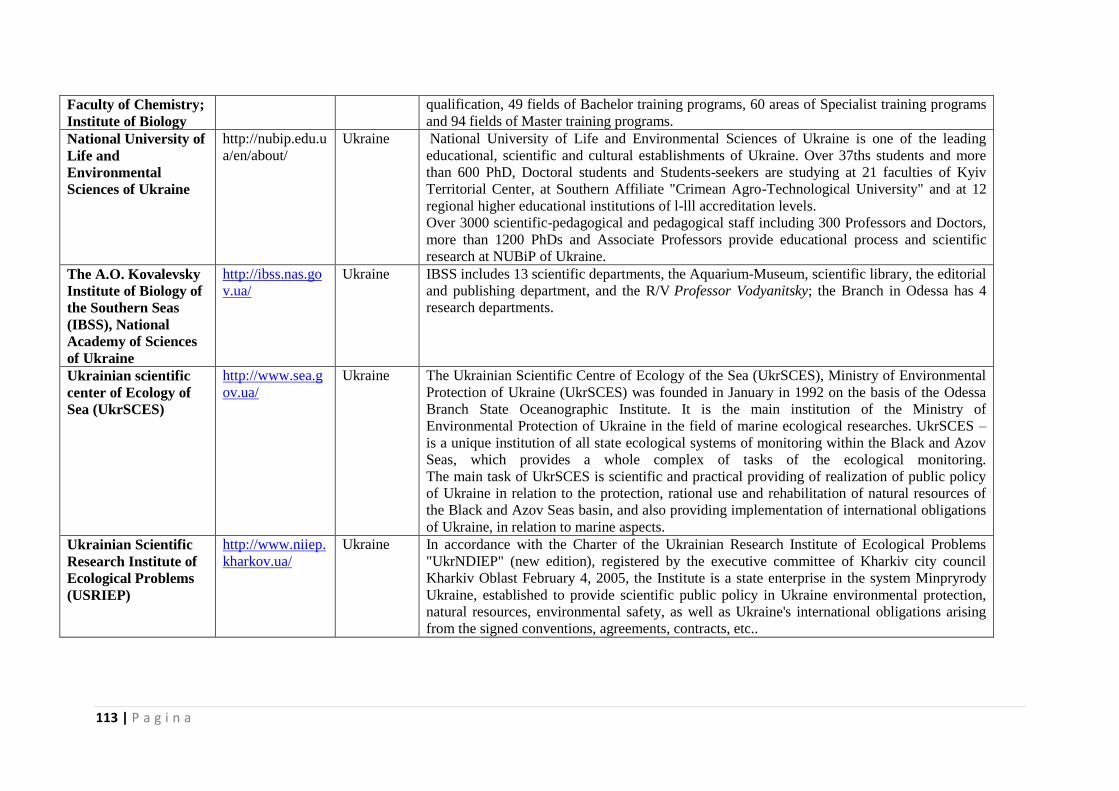
113 | P a g i n a
Faculty of Chemistry;
Institute of Biology
qualification, 49 fields of Bachelor training programs, 60 areas of Specialist training programs
and 94 fields of Master training programs.
National University of
Life and
Environmental
Sciences of Ukraine
http://nubip.edu.u
a/en/about/
Ukraine National University of Life and Environmental Sciences of Ukraine is one of the leading
educational, scientific and cultural establishments of Ukraine. Over 37ths students and more
than 600 PhD, Doctoral students and Students-seekers are studying at 21 faculties of Kyiv
Territorial Center, at Southern Affiliate "Crimean Agro-Technological University" and at 12
regional higher educational institutions of l-lll accreditation levels.
Over 3000 scientific-pedagogical and pedagogical staff including 300 Professors and Doctors,
more than 1200 PhDs and Associate Professors provide educational process and scientific
research at NUBiP of Ukraine.
The A.O. Kovalevsky
Institute of Biology of
the Southern Seas
(IBSS), National
Academy of Sciences
of Ukraine
http://ibss.nas.go
v.ua/
Ukraine IBSS includes 13 scientific departments, the Aquarium-Museum, scientific library, the editorial
and publishing department, and the R/V Professor Vodyanitsky; the Branch in Odessa has 4
research departments.
Ukrainian scientific
center of Ecology of
Sea (UkrSCES)
http://www.sea.g
ov.ua/
Ukraine The Ukrainian Scientific Centre of Ecology of the Sea (UkrSCES), Ministry of Environmental
Protection of Ukraine (UkrSCES) was founded in January in 1992 on the basis of the Odessa
Branch State Oceanographic Institute. It is the main institution of the Ministry of
Environmental Protection of Ukraine in the field of marine ecological researches. UkrSCES –
is a unique institution of all state ecological systems of monitoring within the Black and Azov
Seas, which provides a whole complex of tasks of the ecological monitoring.
The main task of UkrSCES is scientific and practical providing of realization of public policy
of Ukraine in relation to the protection, rational use and rehabilitation of natural resources of
the Black and Azov Seas basin, and also providing implementation of international obligations
of Ukraine, in relation to marine aspects.
Ukrainian Scientific
Research Institute of
Ecological Problems
(USRIEP)
http://www.niiep.
kharkov.ua/
Ukraine In accordance with the Charter of the Ukrainian Research Institute of Ecological Problems
"UkrNDIEP" (new edition), registered by the executive committee of Kharkiv city council
Kharkiv Oblast February 4, 2005, the Institute is a state enterprise in the system Minpryrody
Ukraine, established to provide scientific public policy in Ukraine environmental protection,
natural resources, environmental safety, as well as Ukraine's international obligations arising
from the signed conventions, agreements, contracts, etc..
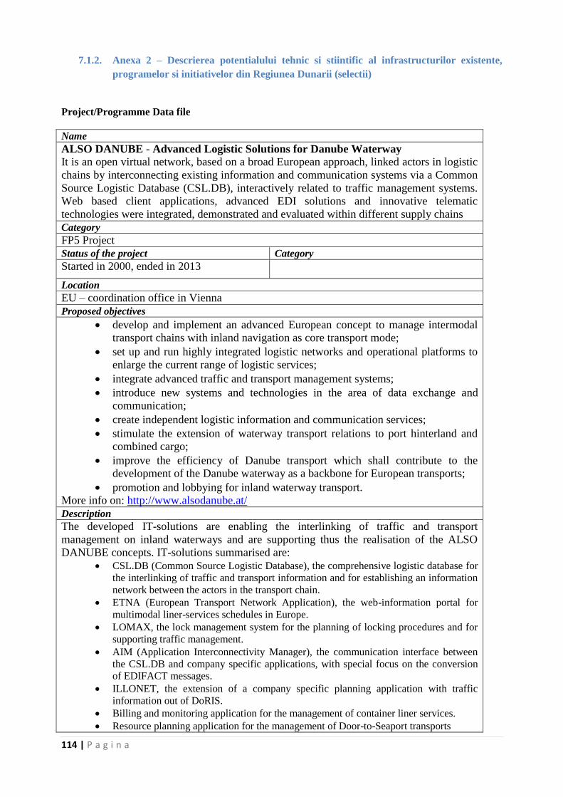
114 | P a g i n a
7.1.2. Anexa 2 – Descrierea potentialului tehnic si stiintific al infrastructurilor existente,
programelor si initiativelor din Regiunea Dunarii (selectii)
Project/Programme Data file
Name
ALSO DANUBE - Advanced Logistic Solutions for Danube Waterway
It is an open virtual network, based on a broad European approach, linked actors in logistic
chains by interconnecting existing information and communication systems via a Common
Source Logistic Database (CSL.DB), interactively related to traffic management systems.
Web based client applications, advanced EDI solutions and innovative telematic
technologies were integrated, demonstrated and evaluated within different supply chains
Category
FP5 Project
Status of the project Category
Started in 2000, ended in 2013
Location
EU – coordination office in Vienna
Proposed objectives
develop and implement an advanced European concept to manage intermodal
transport chains with inland navigation as core transport mode;
set up and run highly integrated logistic networks and operational platforms to
enlarge the current range of logistic services;
integrate advanced traffic and transport management systems;
introduce new systems and technologies in the area of data exchange and
communication;
create independent logistic information and communication services;
stimulate the extension of waterway transport relations to port hinterland and
combined cargo;
improve the efficiency of Danube transport which shall contribute to the
development of the Danube waterway as a backbone for European transports;
promotion and lobbying for inland waterway transport.
More info on: http://www.alsodanube.at/
Description
The developed IT-solutions are enabling the interlinking of traffic and transport
management on inland waterways and are supporting thus the realisation of the ALSO
DANUBE concepts. IT-solutions summarised are:
CSL.DB (Common Source Logistic Database), the comprehensive logistic database for
the interlinking of traffic and transport information and for establishing an information
network between the actors in the transport chain.
ETNA (European Transport Network Application), the web-information portal for
multimodal liner-services schedules in Europe.
LOMAX, the lock management system for the planning of locking procedures and for
supporting traffic management.
AIM (Application Interconnectivity Manager), the communication interface between
the CSL.DB and company specific applications, with special focus on the conversion
of EDIFACT messages.
ILLONET, the extension of a company specific planning application with traffic
information out of DoRIS.
Billing and monitoring application for the management of container liner services.
Resource planning application for the management of Door-to-Seaport transports
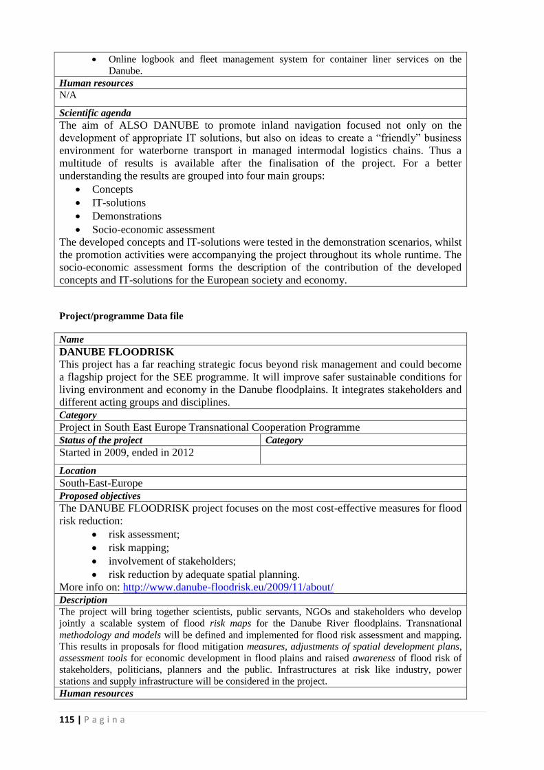
115 | P a g i n a
Online logbook and fleet management system for container liner services on the
Danube.
Human resources
N/A
Scientific agenda
The aim of ALSO DANUBE to promote inland navigation focused not only on the
development of appropriate IT solutions, but also on ideas to create a “friendly” business
environment for waterborne transport in managed intermodal logistics chains. Thus a
multitude of results is available after the finalisation of the project. For a better
understanding the results are grouped into four main groups:
Concepts
IT-solutions
Demonstrations
Socio-economic assessment
The developed concepts and IT-solutions were tested in the demonstration scenarios, whilst
the promotion activities were accompanying the project throughout its whole runtime. The
socio-economic assessment forms the description of the contribution of the developed
concepts and IT-solutions for the European society and economy.
Project/programme Data file
Name
DANUBE FLOODRISK
This project has a far reaching strategic focus beyond risk management and could become
a flagship project for the SEE programme. It will improve safer sustainable conditions for
living environment and economy in the Danube floodplains. It integrates stakeholders and
different acting groups and disciplines.
Category
Project in South East Europe Transnational Cooperation Programme
Status of the project Category
Started in 2009, ended in 2012
Location
South-East-Europe
Proposed objectives
The DANUBE FLOODRISK project focuses on the most cost-effective measures for flood
risk reduction:
risk assessment;
risk mapping;
involvement of stakeholders;
risk reduction by adequate spatial planning.
More info on: http://www.danube-floodrisk.eu/2009/11/about/
Description
The project will bring together scientists, public servants, NGOs and stakeholders who develop
jointly a scalable system of flood risk maps for the Danube River floodplains. Transnational
methodology and models will be defined and implemented for flood risk assessment and mapping.
This results in proposals for flood mitigation measures, adjustments of spatial development plans,
assessment tools for economic development in flood plains and raised awareness of flood risk of
stakeholders, politicians, planners and the public. Infrastructures at risk like industry, power
stations and supply infrastructure will be considered in the project.
Human resources
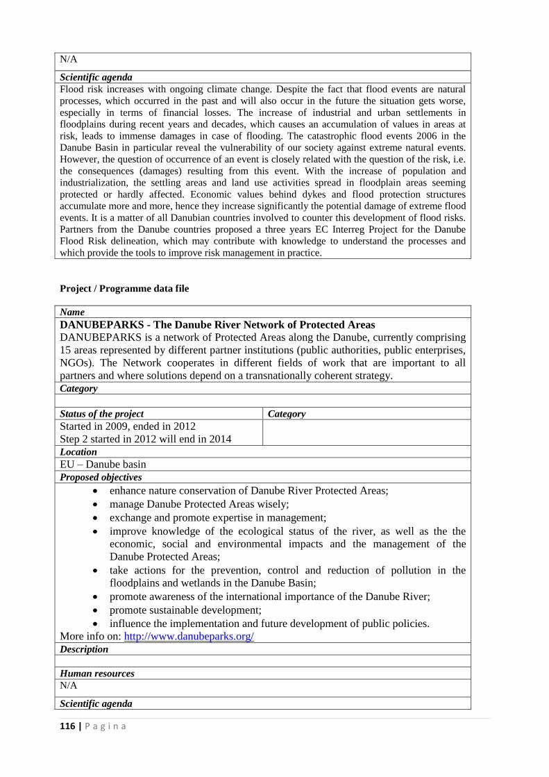
116 | P a g i n a
N/A
Scientific agenda
Flood risk increases with ongoing climate change. Despite the fact that flood events are natural
processes, which occurred in the past and will also occur in the future the situation gets worse,
especially in terms of financial losses. The increase of industrial and urban settlements in
floodplains during recent years and decades, which causes an accumulation of values in areas at
risk, leads to immense damages in case of flooding. The catastrophic flood events 2006 in the
Danube Basin in particular reveal the vulnerability of our society against extreme natural events.
However, the question of occurrence of an event is closely related with the question of the risk, i.e.
the consequences (damages) resulting from this event. With the increase of population and
industrialization, the settling areas and land use activities spread in floodplain areas seeming
protected or hardly affected. Economic values behind dykes and flood protection structures
accumulate more and more, hence they increase significantly the potential damage of extreme flood
events. It is a matter of all Danubian countries involved to counter this development of flood risks.
Partners from the Danube countries proposed a three years EC Interreg Project for the Danube
Flood Risk delineation, which may contribute with knowledge to understand the processes and
which provide the tools to improve risk management in practice.
Project / Programme data file
Name
DANUBEPARKS - The Danube River Network of Protected Areas
DANUBEPARKS is a network of Protected Areas along the Danube, currently comprising
15 areas represented by different partner institutions (public authorities, public enterprises,
NGOs). The Network cooperates in different fields of work that are important to all
partners and where solutions depend on a transnationally coherent strategy.
Category
Status of the project Category
Started in 2009, ended in 2012
Step 2 started in 2012 will end in 2014
Location
EU – Danube basin
Proposed objectives
enhance nature conservation of Danube River Protected Areas;
manage Danube Protected Areas wisely;
exchange and promote expertise in management;
improve knowledge of the ecological status of the river, as well as the the
economic, social and environmental impacts and the management of the
Danube Protected Areas;
take actions for the prevention, control and reduction of pollution in the
floodplains and wetlands in the Danube Basin;
promote awareness of the international importance of the Danube River;
promote sustainable development;
influence the implementation and future development of public policies.
More info on: http://www.danubeparks.org/
Description
Human resources
N/A
Scientific agenda
117 | P a g i n a
River Morphology and Revitalisation; The DANUBEPARKS Strategy on
Conservation and Navigation, including ways to deal with river engineering projects and their
impacts on nature in the Protected Areas, and the Danube River’s Morphology and Revitalisation,
assembling experiences from the past.Additionally, several demonstrative and innovative
revitalisation projects were implemented (e.g. opening of river branches, adaptation of groyns), and
study visits as well as an international workshop were organised.
Floodplain Management and Habitat Network: During this project cross-border
management plans for the AT-SK, HU-HR and HU-RS areas were developed as a basis for more
coherent nature management. The “Perspectives for Danube Floodplain Forests” laid down the
general goals of the Protected Areas regarding future implementation measures in forestry. Last but
not least, pilot projects (e.g. planting of native trees, mowing and grazing) and study visits, also
with external stakeholders, were implemented.
Protection of Danube Flagship Species: White-tailed Eagle and Danube Sturgeon
both demonstrate the necessity of an interlinked and uninterrupted habitat network along the
Danube. For Sturgeons, cooperation was started with research institutions and communication tools
were established. The Action Plan for White-tailed Eagle at the Danube River – developed together
with experts – was adopted and published by the Council of Europe / Bern Convention. A White-
tailed Eagle Database was established online to collect international monitoring data coherently.
Monitoring and Natura2000: Handbooks and studies were published to enhance
management and monitoring of important species, such as Beaver or European Mink, or general
Natura2000 areas. An online database for fish monitoring data has been established. The results of
the Danube-wide monitoring of Little-ringed Plover and Sandmartin (indicator species for dynamic
river sections) demonstrate the need for further revitalisation and protection.
Danube Nature Tourism: The Joint Ranger Training in 2010 provided the basis for
many Protected Areas to guide foreign visitors and communicate to visitors the necessity of
transnational cooperation. A Position and Action Plan for tourism and environmental education
now serves as the basis for future actions. Several Protected Areas also developed pilot offers (boat
and bike tours, nature trails). Communication tools such as the joint tourism brochure and online
tourism platform help in marketing the newly established offers.
Project / Programme data file
Name
EnviroGRIDS
Building Capacity for a Black Sea Catchment Observation and Assessment System
supporting Sustainable Development
Category
FP7 Project
Status of the project Category
Finished Relations can be developed between
DANUBIUS and the community that
administer and uses the data portal.
Location
Black Sea Catchment Area
Proposed objectives
General objectives: The scientific aim of the EnviroGRIDS project is to assemble an
observation system of the Black Sea catchment that will address several GEO Societal
Benefit Areas within a changing climate framework. This system will incorporate a shared
information system that operates on the boundary of scientific/technical partners,
stakeholders and the public. It will contain an early warning system able to inform in
advance decision-makers and the public about risks to human health, biodiversity and
ecosystems integrity, agriculture production or energy supply caused by climatic,
demographic and land cover changes on a 50-year time horizon.
118 | P a g i n a
Technical objectives: The generic technical objectives of the EnviroGRIDS project are to:
run a gap analysis of existing regional observation systems to prepare
recommendations for improvement of networks of data acquisition in each
region/country,
build capacity on observation systems in the Black Sea catchment,
improve regional network to coordinate the efforts of partners active in observation
systems
link, gather, store, manage and distribute key environmental data,
develop the access to real time data from sensors and satellites,
create spatially explicit scenarios of key changes in land cover, climate and
demography,
distribute large calculations and datasets on large computer clusters,
streamline the production of indicators on sustainability and vulnerability of
societal benefits,
provide a standard for integrating data, models and information and communication
tools,
provide policy-makers and citizens with early warning and decision support tools at
regional, national and local levels.
produce innovative tools to visualize and interpret data and results of integrated
models,
alert citizens concerning exposure to environmental risks,
build capacities in the implementation of many new standards and frameworks
(INSPIRE, GEOSS, OGC,..).
Beyond state-of-the-art: EnviroGRIDS is clearly going beyond the state of the art in the
Black Sea region by adopting a catchment approach and by tackling several societal
benefits areas together. By using the most powerful computer network of the world it is
clearly showing the direction on how to analyse the increasing amount of global data made
available throughout the planet. It is bringing crucial information in a relatively data-poor
region on future scenarios of expected climate, demographic and land cover changes.
Based on the outputs of these scenarios it is building geoprocessing services in key societal
benefits areas that will be connected back to the GEOSS.
Main innovations: Contribute to free publicly-funded data through interoperable databases and
services
Streamline data process from data warehouses, to scenarios, hydrological models,
impacts assessments and finally to disseminations tools.
Use grid enabled computer technology to store and analyse environment data
Gridify the code of hydrological model calibration and validation
Create regional scenarios of development in function of expected climate, land
cover and demographic changes
Build efficient virtual and life trainings on EnviroGRIDS main topics
Make available useful open source software and data on DVD and on Internet
Raise public and decision-makers awareness through innovative collaborative
systems
Provide an early warning system to inform the citizens and decision-makers on
environmental vulnerability and risks associated to selected Societal Benefit Area
Description
BSC-OS Portal
Grid - enabled Spatial Data Infrastructure (GSDI) becoming one of the integral systems in
the Global Earth Observation System of Systems (GEOSS), and compatible with the new
EU directive on Infrastructure for Spatial Information in the European Union (INSPIRE),
as well as UNSDI developments.
119 | P a g i n a
Human resources
>100
Scientific agenda
Environmental data
Project / Programme data file
Name
PEGASO - People for Ecosystem-based Governance in Assessing Sustainable
Development of Ocean and Coast
Category
FP 7 project
Status of the project Category
Ongoing
Location
Black Sea and Mediterranean basins
Proposed objectives
To construct an ICZM (Integrated Coastal Zone management) governance platform,
consistent with the aims of article 14 of the ICZM protocol for the Mediterranean,
to support the development of integrated policies for the coastal, marine and
maritime realms of the Mediterranean and Black sea basins.
To build in collaboration a spatial data infrastructure (SDI) for the Mediterranean
and the Black Sea. Supporting and creating local geonodes, in order to deliver a
Mediterranean and Black Sea harmonised sets of data, accessible through an
Internet viewer.
To refine and further develop efficient and easy to use tools for making
sustainability assessments in the coastal zone
To test and validate the assessment tools at regional and local scales to understand
both global and cumulative local trends and how they interact in specific coastal
and marine regions.
To establish and strengthen mechanisms for networking and capacity development
so as to promote knowledge transfer and the long-term use of the project outputs.
To establish and strengthen mechanisms for networking and diffusion of PEGASO
outputs so as to enlarge network of interested stakeholders and the large public.
More info on: www.pegasoproject.eu Description
Spatial Data Infrastructure (SDI), following the INSPIRE Directive, to organize and
standardize spatial data to support information sharing on an interactive visor, to make it
available to the ICZM Platform, and to disseminate all results of the project to the end
users and interested parties.
Human resources
>1000
Scientific agenda
The main goal of the PEGASO project is to construct a shared Integrated Coastal
Zone Management (ICZM) Governance Platform (figure 1) with scientists, users
and decision-makers linked with new models of governance.
Project / Programme data file
Name of the infrastructure
120 | P a g i n a
FAST – Foreshore Assessment Using Space Technology
Category of infrastructure
FP 7 project
Status of the project Category of infrastructure
Ongoing
Location
Black Sea, Cadiz Bay, North Sea
Proposed objectives
FAST is a multi-disciplinary project that aims to study the role of vegetation in flood risk
mitigation, as a cost-effective flood defence solution. Using a combination of remote sensing and
field data from foreshores in four different EU countries (The Netherlands, UK, Romania and
Spain), FAST will look at how specific characteristics of vegetated foreshores affect wave energy
and erosion and develop novel ways to get the information needed from satellite images, so as to
predict shoreline protection.
All this know-how will be developed, in close collaboration with end-users, into an easy-to use
service (presently code named MI-SAFE). MI-SAFE will be a sustainable, long-term contribution
to European flood risk management, allowing governmental agencies, industry consultants, NGOs
and Citizens, to easily assess the potential of vegetated foreshores in reducing flood and erosion
risks.
Description of the current infrastructure
The FAST approach fuses recent advances in integrated coastal zone management (ICZM), climate
change adaptation and the application of ecosystem services concepts into a next generation
software package for foreshore management based on the unprecedented spatio-temporal coverage
of the ambitious European Earth Observation Programme Copernicus (www.copernicus.eu).
Using an agile development approach end-users will cooperate throughout the entire project,
providing input into the selection of case study sites, fieldwork, algorithm development and
strategies to ensure the long-term sustainability of the service (presently code named MI-SAFE).
Human resources
>100
Scientific agenda
1. Linking data from satellite images to the biophysics of coastal wetland systems.
2. Developing generic algorithms for the classification of coastal wetland characteristics on satellite
images.
3. Linking biophysical characteristics of coastal wetlands to wave and/or flow attenuation and
erosion/deposition patterns for different water levels and wave heights/flow speeds through field
measurements.
4. Translating the effects of foreshores and floodplains on waves/flow and stability into impacts on
engineering requirements for flood safety infrastructure.
5. Developing a service for the improvement of flood and erosion risk management strategies in
coastal wetlands, including a prototype user-friendly software tool (MI-SAFE) where linkages
between biological and morphological features of foreshores/floodplains and requirements for flood
safety infrastructure are automated.
Project / Programme data file
Name of the infrastructure
RISES-AM - Responses to coastal climate change: Innovative Strategies for high End
Scenarios -Adaptation and Mitigation
Category of infrastructure
FP 7 project
Status of the project Category of infrastructure
Ongoing
Location
Black Sea, Mediterranean Sea, North Sea
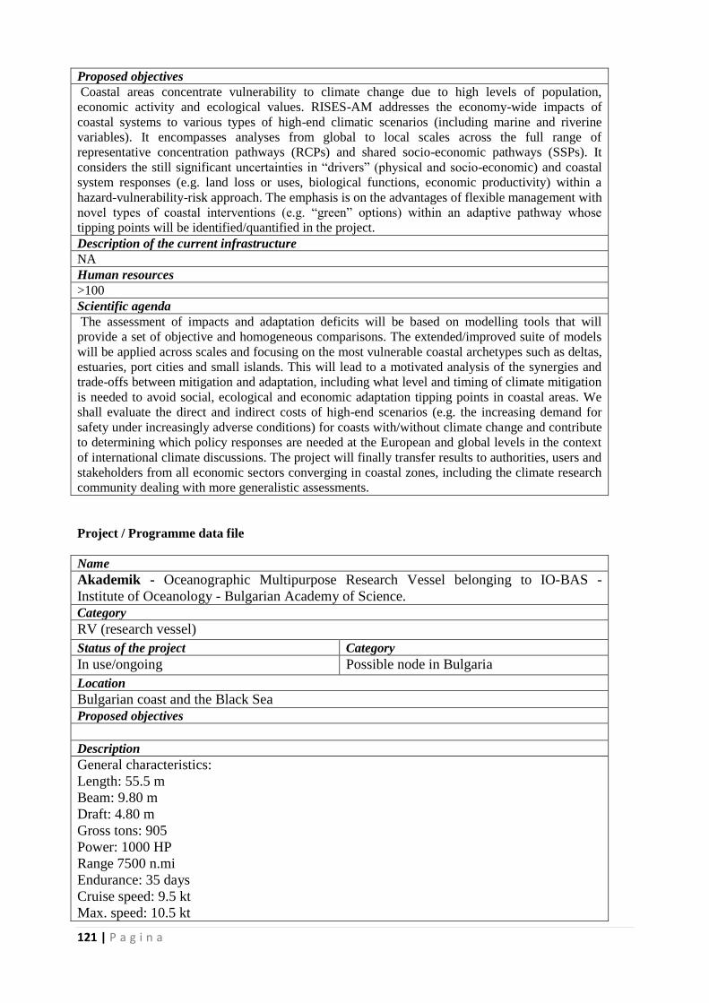
121 | P a g i n a
Proposed objectives
Coastal areas concentrate vulnerability to climate change due to high levels of population,
economic activity and ecological values. RISES-AM addresses the economy-wide impacts of
coastal systems to various types of high-end climatic scenarios (including marine and riverine
variables). It encompasses analyses from global to local scales across the full range of
representative concentration pathways (RCPs) and shared socio-economic pathways (SSPs). It
considers the still significant uncertainties in “drivers” (physical and socio-economic) and coastal
system responses (e.g. land loss or uses, biological functions, economic productivity) within a
hazard-vulnerability-risk approach. The emphasis is on the advantages of flexible management with
novel types of coastal interventions (e.g. “green” options) within an adaptive pathway whose
tipping points will be identified/quantified in the project.
Description of the current infrastructure
NA
Human resources
>100
Scientific agenda
The assessment of impacts and adaptation deficits will be based on modelling tools that will
provide a set of objective and homogeneous comparisons. The extended/improved suite of models
will be applied across scales and focusing on the most vulnerable coastal archetypes such as deltas,
estuaries, port cities and small islands. This will lead to a motivated analysis of the synergies and
trade-offs between mitigation and adaptation, including what level and timing of climate mitigation
is needed to avoid social, ecological and economic adaptation tipping points in coastal areas. We
shall evaluate the direct and indirect costs of high-end scenarios (e.g. the increasing demand for
safety under increasingly adverse conditions) for coasts with/without climate change and contribute
to determining which policy responses are needed at the European and global levels in the context
of international climate discussions. The project will finally transfer results to authorities, users and
stakeholders from all economic sectors converging in coastal zones, including the climate research
community dealing with more generalistic assessments.
Project / Programme data file
Name
Akademik - Oceanographic Multipurpose Research Vessel belonging to IO-BAS -
Institute of Oceanology - Bulgarian Academy of Science.
Category
RV (research vessel)
Status of the project Category
In use/ongoing Possible node in Bulgaria
Location
Bulgarian coast and the Black Sea
Proposed objectives
Description
General characteristics:
Length: 55.5 m
Beam: 9.80 m
Draft: 4.80 m
Gross tons: 905
Power: 1000 HP
Range 7500 n.mi
Endurance: 35 days
Cruise speed: 9.5 kt
Max. speed: 10.5 kt
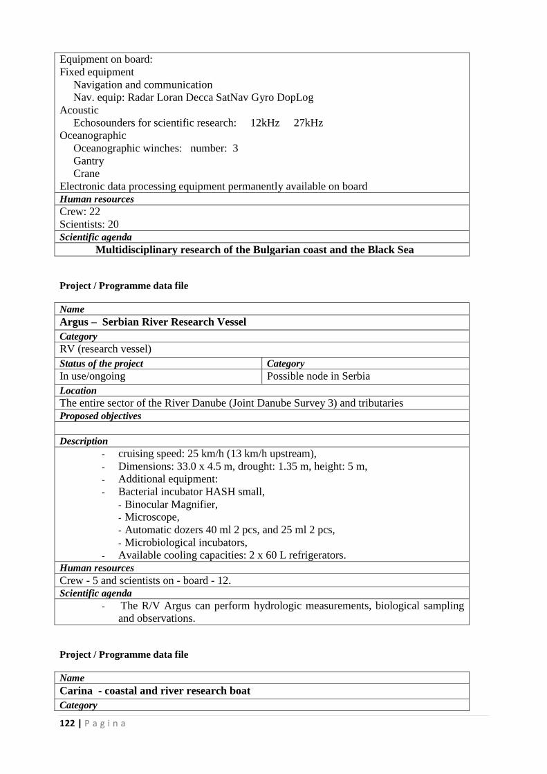
122 | P a g i n a
Equipment on board:
Fixed equipment
Navigation and communication
Nav. equip: Radar Loran Decca SatNav Gyro DopLog
Acoustic
Echosounders for scientific research: 12kHz 27kHz
Oceanographic
Oceanographic winches: number: 3
Gantry
Crane
Electronic data processing equipment permanently available on board
Human resources
Crew: 22
Scientists: 20
Scientific agenda
Multidisciplinary research of the Bulgarian coast and the Black Sea
Project / Programme data file
Name
Argus – Serbian River Research Vessel
Category
RV (research vessel)
Status of the project Category
In use/ongoing Possible node in Serbia
Location
The entire sector of the River Danube (Joint Danube Survey 3) and tributaries
Proposed objectives
Description
- cruising speed: 25 km/h (13 km/h upstream),
- Dimensions: 33.0 x 4.5 m, drought: 1.35 m, height: 5 m,
- Additional equipment:
- Bacterial incubator HASH small,
- Binocular Magnifier,
- Microscope,
- Automatic dozers 40 ml 2 pcs, and 25 ml 2 pcs,
- Microbiological incubators,
- Available cooling capacities: 2 x 60 L refrigerators.
Human resources
Crew - 5 and scientists on - board - 12.
Scientific agenda
- The R/V Argus can perform hydrologic measurements, biological sampling
and observations.
Project / Programme data file
Name
Carina - coastal and river research boat
Category
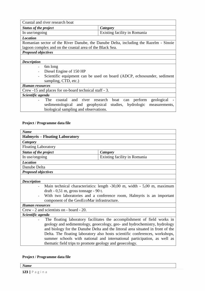
123 | P a g i n a
Coastal and river research boat
Status of the project Category
In use/ongoing Existing facility in Romania
Location
Romanian sector of the River Danube, the Danube Delta, including the Razelm - Sinoie
lagoon complex and on the coastal area of the Black Sea.
Proposed objectives
Description
- 6m long
- Diesel Engine of 150 HP
- Scientific equipment can be used on board (ADCP, echosounder, sediment
sampling, CTD, etc.)
Human resources
Crew -15 and places for on-board technical staff - 3.
Scientific agenda
- The coastal and river research boat can perform geological -
sedimentological and geophysical studies, hydrologic measurements,
biological sampling and observations.
Project / Programme data file
Name
Halmyris – Floating Laboratory
Category
Floating Laboratory
Status of the project Category
In use/ongoing Existing facility in Romania
Location
Danube Delta
Proposed objectives
Description
- Main technical characteristics: length -30,00 m, width - 5,00 m, maximum
draft - 0,51 m, gross tonnage - 90 t.
- With two laboratories and a conference room, Halmyris is an important
component of the GeoEcoMar infrastructure.
Human resources
Crew - 2 and scientists on - board - 20.
Scientific agenda
- The floating laboratory facilitates the accomplishment of field works in
geology and sedimentology, geoecology, geo- and hydrochemistry, hydrology
and biology for the Danube Delta and the littoral area situated in front of the
Delta. The floating laboratory also hosts scientific conferences, workshops,
summer schools with national and international participation, as well as
thematic field trips to promote geology and geoecology.
Project / Programme data file
Name
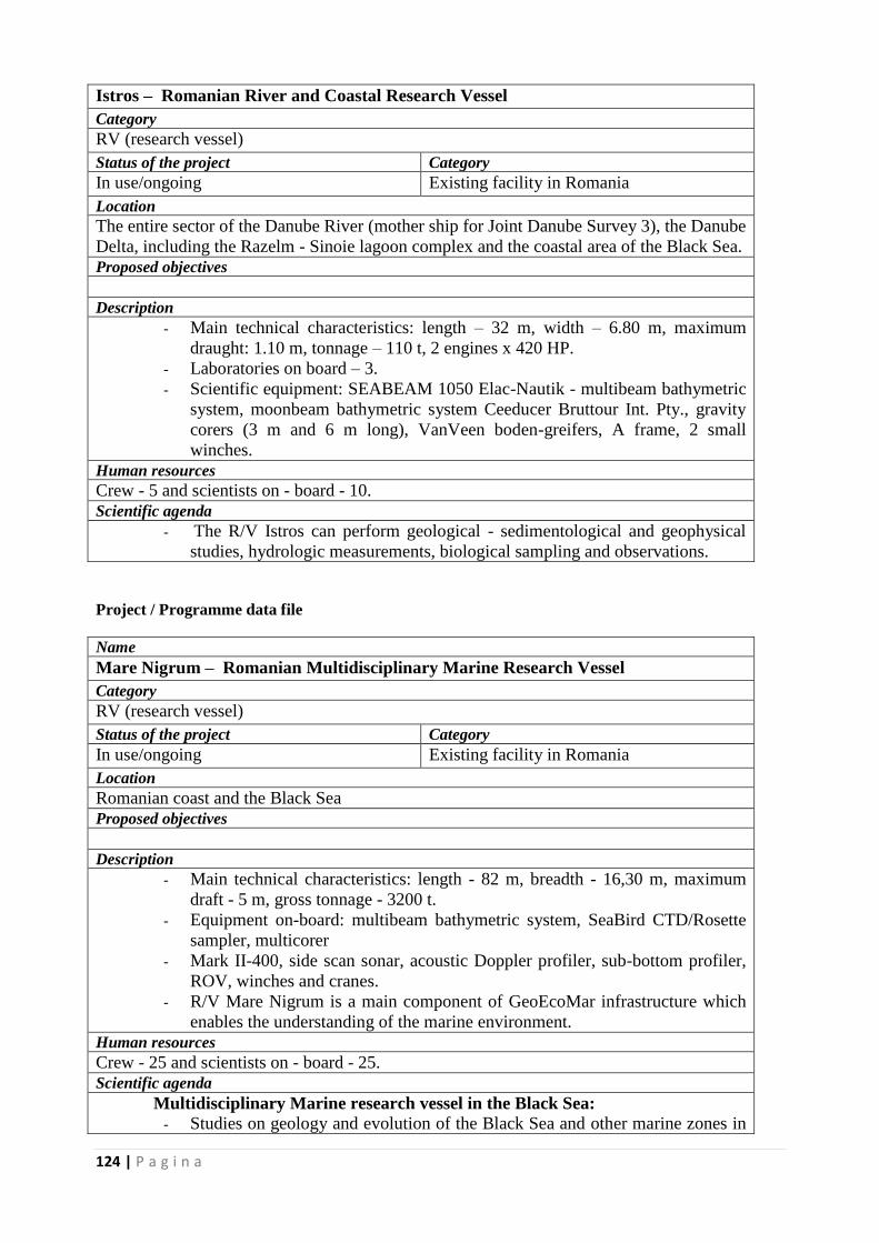
124 | P a g i n a
Istros – Romanian River and Coastal Research Vessel
Category
RV (research vessel)
Status of the project Category
In use/ongoing Existing facility in Romania
Location
The entire sector of the Danube River (mother ship for Joint Danube Survey 3), the Danube
Delta, including the Razelm - Sinoie lagoon complex and the coastal area of the Black Sea.
Proposed objectives
Description
- Main technical characteristics: length – 32 m, width – 6.80 m, maximum
draught: 1.10 m, tonnage – 110 t, 2 engines x 420 HP.
- Laboratories on board – 3.
- Scientific equipment: SEABEAM 1050 Elac-Nautik - multibeam bathymetric
system, moonbeam bathymetric system Ceeducer Bruttour Int. Pty., gravity
corers (3 m and 6 m long), VanVeen boden-greifers, A frame, 2 small
winches.
Human resources
Crew - 5 and scientists on - board - 10.
Scientific agenda
- The R/V Istros can perform geological - sedimentological and geophysical
studies, hydrologic measurements, biological sampling and observations.
Project / Programme data file
Name
Mare Nigrum – Romanian Multidisciplinary Marine Research Vessel
Category
RV (research vessel)
Status of the project Category
In use/ongoing Existing facility in Romania
Location
Romanian coast and the Black Sea
Proposed objectives
Description
- Main technical characteristics: length - 82 m, breadth - 16,30 m, maximum
draft - 5 m, gross tonnage - 3200 t.
- Equipment on-board: multibeam bathymetric system, SeaBird CTD/Rosette
sampler, multicorer
- Mark II-400, side scan sonar, acoustic Doppler profiler, sub-bottom profiler,
ROV, winches and cranes.
- R/V Mare Nigrum is a main component of GeoEcoMar infrastructure which
enables the understanding of the marine environment.
Human resources
Crew - 25 and scientists on - board - 25.
Scientific agenda
Multidisciplinary Marine research vessel in the Black Sea:
- Studies on geology and evolution of the Black Sea and other marine zones in
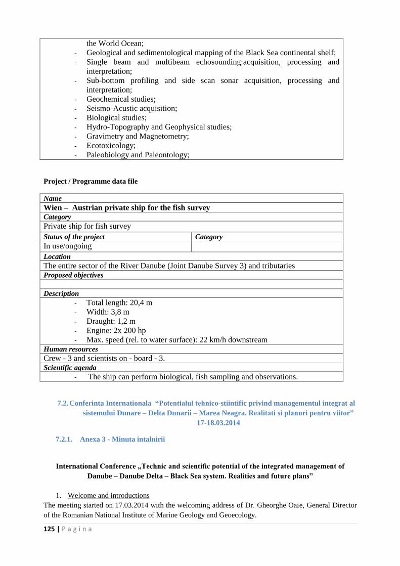
125 | P a g i n a
the World Ocean;
- Geological and sedimentological mapping of the Black Sea continental shelf;
- Single beam and multibeam echosounding:acquisition, processing and
interpretation;
- Sub-bottom profiling and side scan sonar acquisition, processing and
interpretation;
- Geochemical studies;
- Seismo-Acustic acquisition;
- Biological studies;
- Hydro-Topography and Geophysical studies;
- Gravimetry and Magnetometry;
- Ecotoxicology;
- Paleobiology and Paleontology;
Project / Programme data file
Name
Wien – Austrian private ship for the fish survey Category
Private ship for fish survey
Status of the project Category
In use/ongoing
Location
The entire sector of the River Danube (Joint Danube Survey 3) and tributaries
Proposed objectives
Description
- Total length: 20,4 m
- Width: 3,8 m
- Draught: 1,2 m
- Engine: 2x 200 hp
- Max. speed (rel. to water surface): 22 km/h downstream
Human resources
Crew - 3 and scientists on - board - 3.
Scientific agenda
- The ship can perform biological, fish sampling and observations.
7.2. Conferinta Internationala “Potentialul tehnico-stiintific privind managementul integrat al
sistemului Dunare – Delta Dunarii – Marea Neagra. Realitati si planuri pentru viitor”
17-18.03.2014
7.2.1. Anexa 3 - Minuta intalnirii
International Conference „Technic and scientific potential of the integrated management of
Danube – Danube Delta – Black Sea system. Realities and future plans”
1. Welcome and introductions
The meeting started on 17.03.2014 with the welcoming address of Dr. Gheorghe Oaie, General Director
of the Romanian National Institute of Marine Geology and Geoecology.
126 | P a g i n a
He showed the importance of DANUBIUS – RI as a future pan-European infrastructure and multi-
disciplinary project, pointing out that relations must be created between FP7 project DANCERS
(Building Excellence in the Danube Region) project and DANUBIUS – RI.
Formal around the table introductions followed, then discussions started.
2. New Research and Innovation opportunities provided by the Horizon 2020 Programme in the
Danube Region
Dr. Viorel Vulturescu, Director for European Integration and International Cooperation in the Romanian
Ministry of National Education presented the main opportunities provided by the Horizon 2020
programme in the Danube Region.
Horizon 2020 programme combines the former funding programmes for R&I - 7th EU Framework
Programme for Research, European Institute of Innovation and Technology (EIT), innovation parts of
Competitiveness and Innovation Programme (CIP):
Focuses more on innovation: closing the gap between knowledge and market, stronger
participation of SMEs.
Promotes solutions for societal challenges with visible socio-economic impact
It is simplified (single set of simplified rules, reducing time-to-grant, single IT Participant
Portal).
The three main pillars of the programme are:
I. Excellent Science
II. Industrial Leadership
III. Societal Challenges
Spreading Excellence and Widening Participation
Science with and for Society
Other actions are:
European Institute of Innovation and Technology (EIT)
Joint Research Centres (JRC)
EURATOM
The main elements in Pillar I – Excellent science are:
• European Research Council (ERC): support the most talented and creative individuals and their
teams to carry out frontier research
• Future and Emerging Technologies (FET): fund collaborative research to open up new and
promising fields of research and innovation
• Marie Skłodowska-Curie Actions: provide mobility of researchers; focus on training and career
development:
Initial Training Networks (ITN)
o Doctoral and initial training of researchers proposed by international networks of
organisations from public and private sectors
o European TN, Industrial Doctorates, Joint Doctorates
Individual Fellowships (IF)
o Individual fellowships for most promising experienced researchers to develop their skills
through international or inter-sector mobility
o European Fellowship, Re-Integration, Global Fellowships (Return Phase)
Research and Innovation Staff Exchange (RISE)
o International and inter-sector cooperation through the exchange of research and
innovation staff (include administrative, managerial and technical staff)
COFUND
127 | P a g i n a
o Co-funding of regional, national and international programmes covering the above
described actions
• Research infrastructures (EU definition „Facilities, resources and related services used by the
scientific community to conduct top-level research in their respective fields. RI can be single-sited or
distributed“):
Ensure Europe has world-class research infrastructures (including e-infrastructures) accessible to
all researchers in Europe and beyond:
First call for existing but also new RIs, focus on integration (networking, transnational access or
service activities, joint research)
Focus on human capital (training) as a mandate for RIs; innovation potential of RIs (cooperation
with SMEs, PPP)
The main elements of Pillar III – Societal Challenges are:
1. Health, Demographic Change and Wellbeing
2. Food Security, Sustainable Agriculture and Forestry, Marine and Maritime and Inland Water Research
and the Bioeconomy
3. Secure, Clean and Efficient Energy
4. Smart, Green and Integrated Transport
5. Climate action, Environment, Resource Efficiency and Raw Materials
Call – Water Innovation: Boosting its value for Europe
WATER-1-2014/2015: Bridging the gap: from innovative water solutions to market replication
WATER-2-2014/2015: Integrated approaches to water and climate change
WATER-3-2014/2015: Stepping up EU research and innovation cooperation in the water area (ERA
NET COFUND - Water JPI)
WATER-4-2014/2015: Harnessing EU water research and innovation results for industry,
agriculture, policy makers and citizens
WATER-5-2014/2015: Strengthening international R&I cooperation in the field of water
6. Europe In A Changing World – Inclusive, Innovative And Reflective Societies
7. Secure Societies – Protecting Freedom and Security Of Europe And Its Citizens
A very important issue is Spreading Excellence and Widening Participation which refers to:
• A new set of measures introduced in Horizon 2020 under this separate specific objective
(WIDESPREAD), aiming to close the R&I divide between Member States and regions
• A number of countries are experiencing low participation in the EU Framework Programmes
(compared to FP7)
• H2020 legal text >>" low RDI performing” Member States for Widening actions (Latvia,
Croatia, Lithuania, Malta, Slovakia, Romania, Luxembourg, Poland, Bulgaria, Estonia, Portugal,
Slovenia, Cyprus, Czech Republic and Hungary).
IMPLEMENTATION:
• Foster synergies with the European Structural and Investment Funds (ESIF). Measures to be
implemented by the Member States most in need of the new Cohesion policy for the 2014-2020
programming period
Widening participation can be achieved by:
TEAMING - CSA (100%): 1 year (1st phase) + 5-7 years (2nd phase)
Creation of new (or significant upgrade of existing) Centres of Excellence in low performing
Member States and regions
Proposals: Need to demonstrate the long-term science and innovation strategy of the future Centre
based on a SWOT analysis
Stage 1: Funding for the development of a Business Plan for the new Centre of Excellence
facilitated by a teaming process with a leading counterpart in Europe
128 | P a g i n a
Stage 2: Subject to the quality of the Business Plan, and a commitment of the Member State (e.g.
support via Cohesion Policy Funds), the Commission may provide further substantial financial
support for the first steps of implementation of the Centre.
In each Teaming project there is:
(1) the participant organisation (COORDINATOR) from a low performing Member State (for
example a research agency at national or regional level, or a regional authority);
(2) an institution of research and innovation excellence (public or private) or a consortium of such
institutions;
TWINNING:
Strengthening a defined field of research of a knowledge institution in a low performing Member
State or region through linking with at least two internationally-leading counterparts in Europe.
Proposals: Will have to outline the scientific strategy for stepping up and stimulating scientific
excellence and innovation capacity in a defined area of research as well as the scientific quality of the
partners involved in the twinning exercise
Funding for:
expert visits and short-term on-site or virtual training;
workshops & conference attendance;
organisation of joint summer school type activities;
dissemination and outreach activities.
Equipment & researchers' salaries will NOT be funded.
In each Twinning project there is:
ONE institution located in a Low Performing MS/region (COORDINATOR)
A minimum of TWO additional partners from two different Member States or Associated
Countries.
Another important issue in Pillar III is Science with and for society which has as main objective to:
– to build effective cooperation between science and society,
– to recruit new talent for science,
– to pair scientific excellence with social awareness and responsibility.
The rationale is to:
– Increase of quality, relevance and acceptance of European research through interaction with society
– Deals with needs and concerns of society, gender equality, attraction of young people and the general
public to science.
Topics include education, citizen participation in R&I, research outreach, framework conditions for
responsible R&I, incl. ethics.
The main instruments are represented by coordination and support actions, collaborative projects.
3. Introduction to FP7 DANCERS project
Dr. Adrian Stanica made a brief introduction to the FP7 Project DANCERS – DANube macroregion:
Capacity building and Excellence in River Systems (basin, delta and sea).
The main aim of the project is to develop new instruments and tools that will enhance environmental
research and promote innovation in Danube Region, including the Danube Delta and the Black Sea.
Importantly, the new instruments and tools do not start ab initio but will build on existing projects and
expertise.
The specific objectives are to:
critically analyse the achievements in integrated river- delta –sea management in the Danube Region.
understand links between the achievements, deliverables and results of the work performed.
define a set of instruments to enhance environmental research and innovation in Danube Region.
The Consortium comprises partners from:
129 | P a g i n a
Danube Region – Germany (1), Austria (3), Hungary (1), Serbia (1), Romania (2)
EU15 – France (1), Greece (1), Ireland (1), Italy (1), Spain (1), UK (1 sub-consortium of 4
universities)
UNESCO – IHE
The project is structured in the three pillars of knowledge:
science,
research infrastructures
human potential
There are three categories of stakeholders present in the Danube Region:
scientists and academia,
decision and policy makers
business community.
The project will receive input from the stakeholders and aims to develop instruments that contain:
1. Strategic research agenda,
2. Concept and detailed plan of the distributed research infrastructures for the Danube – Black Sea
Macrosystem
3. Proposals for an integrated educational program with the full cooperation of partners from
Danube - Black Sea Macrosystem.
Two comments followed:
Address the EC to obtain continuity in funding research initiatives, as lack of continuity is a
major issue here. This requires the need to develop a dedicated programme to the Danube Region
specific needs.
The partners in the Consortium should participate more in JPI Oceans and to link with
DANUBIUS – RI project explain that it is not dedicated to the Danube Delta and Romania but to
river – delta – sea systems in general.
4. Presentation of the DANCERS Data Base of Projects, Programmes and Initiatives in the
management of river-delta-sea in the Danube Region
Dr. Mihaela Paun, from the Romanian National Institute for Biological Sciences presented the data base
of the project, hosted by the University of Natural Resources and Life Sciences, BOKU, Vienna.
The data base gathers all existing information about projects and their results in the Danube Region with
focus on water and environmental management issues:
• of the last two decades,
• at all geographic levels (national, regional, European, International),
• closely linked to the three main domains: life sciences (including environmental aspects), earth
sciences and socio-economics,
• structured into the three main pillars: Scientific Agenda, R&D Infrastructure and Human Capital and
• based on the Danube River Basin Management Plan (ICPDR 2009),
The metadatabase stays open for further entries and remains active even after the project ends, in 2015.
DANCERS metadatabase serves as basis for further studies, for identifing of strengths and weaknesses,
links and gaps in water management issues in the Danube Region. Its main purposes are to:
• provide structured information for the assessment of the collected projects,
• improve access to the gathered data and
• promote the sharing of obtained knowledge.
Metadata:
• is “data about data” or “information about data”
• provide a short summary about the content, purpose, quality, location of the data as well as
information related to its creation
130 | P a g i n a
The hardware – features:
• standard server configuration with state of the art components
• have sufficient storage space and high security of the data is guaranteed
• all necessary security updates and software updates are provided during the project lifetime
• accessibility of the server is guaranteed at least for one year after project end.
For each project, the metadatabase contains:
Title
Date
Abstract
Key words
For data collection two methods were used:
a. Questionnaire
b. Internet Search
The situation of record in the data base is as follows:
Records in DANCERS metadatabase No of projects
Status: 12.3.2014 476
Composition:
returned questionnaires (deadline 6.2.2014): 256
direct entries into metadatabase 251
Deleted:
duplicates/multiples/not of interest 31
Geographic location
Upper Danube 203
Middle Danube 143
Lower Danube 165
Danube delta 136
Danube coastal zone 48
Western Black Sea 116
Core category
Scientific Agenda 279
Research Infrastructure 48
Human Capital 51
Thematic Area
Life Sciences 145
Earth Sciences 126
Socio-Economics 95
Multidisciplinary 189
Funding Type
EC - DG R&I 96
EC-Other 48
Structural Funds (ERDF, IPA, Cohesion) 37
National R&D 138
National Other (environmental monitoring, maintenance of navigation) 46
International (UN and other) 39
Other 67
Programme Type
Environmental monitoring and measurements 170
Maintenance of navigation 37
Other 77
Research - Human Resources&Education 14
131 | P a g i n a
Research - scientific ideas and scientific cooperation 52
Research - development and upgrading of research infrastructure 162
Status of the project
Completed 372
Ongoing 100
Dr. Paun continued with the presentation of data analysis, made by her team.
Data analysis consisted in:
1. Checking the consistency of all data gathered, deleting duplicates – INSB and GeoEcoMar
2. Implementing the changes in the database - WCL
3. Data Analysis – INSB
The analysis was performed on the data file sent by WCL on February 26th 2014 and the dataset consists
of 472 projects from which:
• 468 recorded answers regarding the status of the project
• 4 projects having missing values.
• Out of the 468 recorded answers
• 370 have been completed
• 98 ongoing
• 463 projects have recorded answers
• 9 missing values.
There are 26 coordinating countries for the 472 projects entered. The analysis of the projects took into
consideration the following criteria: status (completed/ongoing), coordinating country, thematic areas
(life, earth, socio, multi), programme type, funding type, year (no per year).
Some of the results are presented in the following figures:
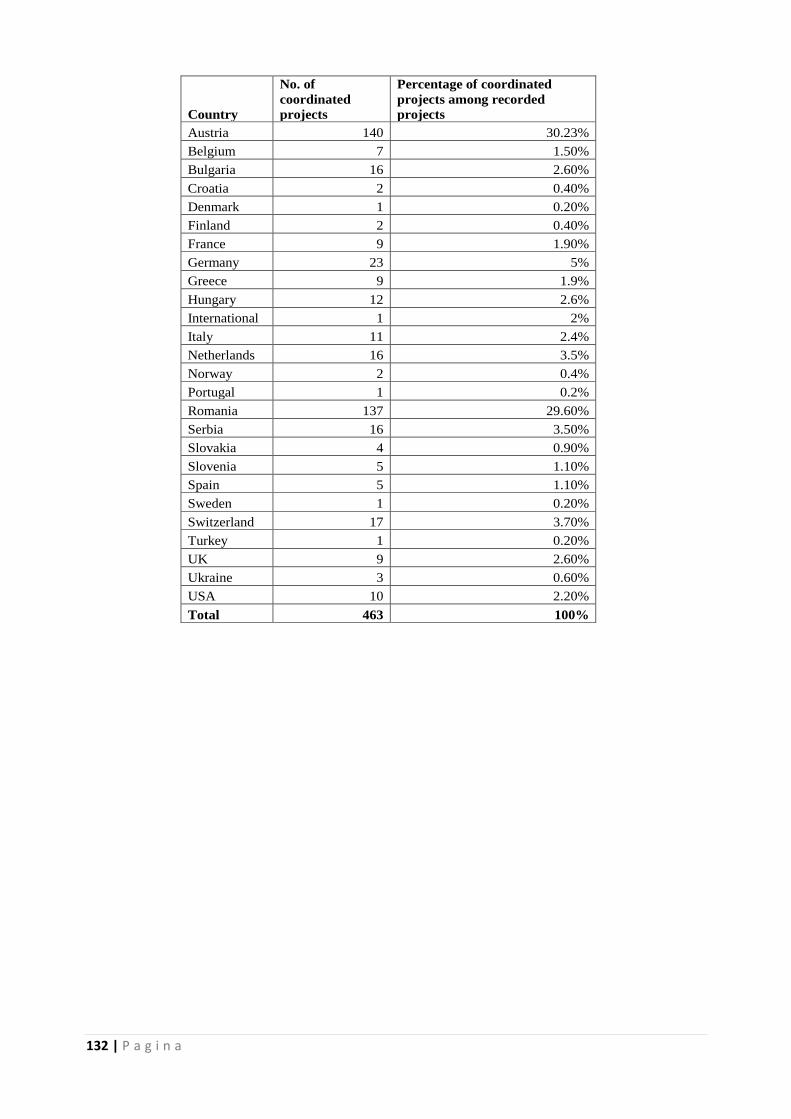
132 | P a g i n a
Country
No. of
coordinated
projects
Percentage of coordinated
projects among recorded
projects
Austria 140 30.23%
Belgium 7 1.50%
Bulgaria 16 2.60%
Croatia 2 0.40%
Denmark 1 0.20%
Finland 2 0.40%
France 9 1.90%
Germany 23 5%
Greece 9 1.9%
Hungary 12 2.6%
International 1 2%
Italy 11 2.4%
Netherlands 16 3.5%
Norway 2 0.4%
Portugal 1 0.2%
Romania 137 29.60%
Serbia 16 3.50%
Slovakia 4 0.90%
Slovenia 5 1.10%
Spain 5 1.10%
Sweden 1 0.20%
Switzerland 17 3.70%
Turkey 1 0.20%
UK 9 2.60%
Ukraine 3 0.60%
USA 10 2.20%
Total 463 100%
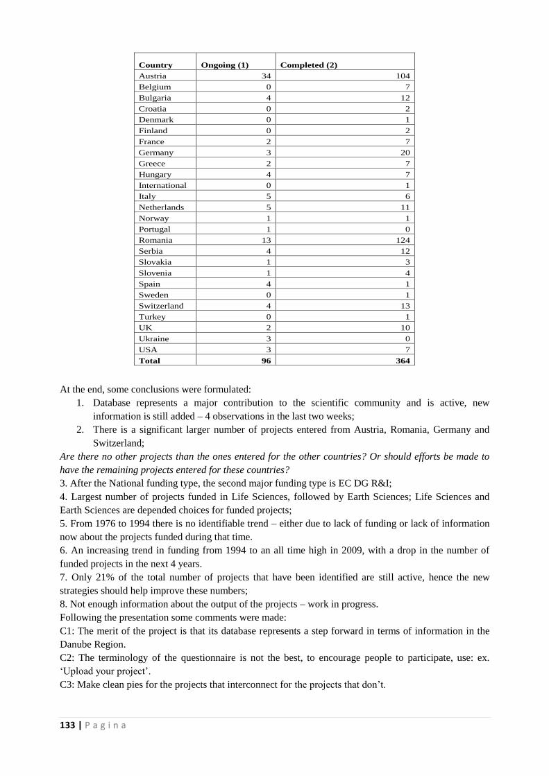
133 | P a g i n a
At the end, some conclusions were formulated:
1. Database represents a major contribution to the scientific community and is active, new
information is still added – 4 observations in the last two weeks;
2. There is a significant larger number of projects entered from Austria, Romania, Germany and
Switzerland;
Are there no other projects than the ones entered for the other countries? Or should efforts be made to
have the remaining projects entered for these countries?
3. After the National funding type, the second major funding type is EC DG R&I;
4. Largest number of projects funded in Life Sciences, followed by Earth Sciences; Life Sciences and
Earth Sciences are depended choices for funded projects;
5. From 1976 to 1994 there is no identifiable trend – either due to lack of funding or lack of information
now about the projects funded during that time.
6. An increasing trend in funding from 1994 to an all time high in 2009, with a drop in the number of
funded projects in the next 4 years.
7. Only 21% of the total number of projects that have been identified are still active, hence the new
strategies should help improve these numbers;
8. Not enough information about the output of the projects – work in progress.
Following the presentation some comments were made:
C1: The merit of the project is that its database represents a step forward in terms of information in the
Danube Region.
C2: The terminology of the questionnaire is not the best, to encourage people to participate, use: ex.
‘Upload your project’.
C3: Make clean pies for the projects that interconnect for the projects that don’t.
Country Ongoing (1) Completed (2)
Austria 34 104
Belgium 0 7
Bulgaria 4 12
Croatia 0 2
Denmark 0 1
Finland 0 2
France 2 7
Germany 3 20
Greece 2 7
Hungary 4 7
International 0 1
Italy 5 6
Netherlands 5 11
Norway 1 1
Portugal 1 0
Romania 13 124
Serbia 4 12
Slovakia 1 3
Slovenia 1 4
Spain 4 1
Sweden 0 1
Switzerland 4 13
Turkey 0 1
UK 2 10
Ukraine 3 0
USA 3 7
Total 96 364
134 | P a g i n a
5. Opportunities for European Cooperation within Horizon 2020 – Societal Challenge 5 on
Integrated Management of River- Delta – Sea Systems (Life Sciences, Earth Sciences,
Environmental Sciences, Water Cycle)
Dr. Adrian Stanica delivered the presentation on behalf of Christos Fragakis, DG Research and
Innovation, who could not be present.
In the Pillar III (Societal challenges) of Horizon 2020, “Climate action, environment, resource efficiency
and raw materials” is an important chapter. Related to this, the main objective is to achieve a resource –
and water – efficient and climate change resilient economy and society, the protection and sustainable
management of natural resources and ecosystems, and a sustainable supply and use of raw materials, in
order to meet the needs of a growing global population within the sustainable limits of the planet's natural
resources and eco-systems.
The broad lines of activities are:
• Fighting and adapting to climate change
• Sustainably managing natural resources and ecosystems
• Sustainable supply of non-energy and non-agricultural raw materials
• Transition towards a green economy through eco-innovation
• Global environmental observation and information systems
• Cultural heritage
In the Work Programme 2014/2015 twelve focus areas were identified, of which five linked to 'Climate
action, environment, resource efficiency and raw materials:
• Waste: A resource to recycle, reuse and recover raw materials
• Water innovation: Boosting its value for Europe
• Energy-efficiency
• Disaster-resilience: Safeguarding society and adapting to climate change
• Blue growth: Unlocking the potential of the oceans
Regarding Water innovation, boosting its value for Europe - areas covered 2014/2015, the main
objectives are:
Bridging the gap: from innovative water solutions to market replication
Integrated approaches to water and climate change
Stepping up EU research and innovation cooperation in the water area
Harnessing EU water research and innovation results for industry, policy makers and citizens
Strengthening international R&I cooperation in the field of water
For bridging the gap, from innovative water solutions to market replication, the main activities are:
Accelerate commercialisation of eco-innovative water solutions (technologies, process, products,
services, etc.)
Stimulate sustainable economic growth, business and job creation in the water sector
Proposals should:
Support first application and market replication of near-market water solutions
Address the 5 thematic priorities identified in the SIP (strategic implementation plan) of the EIP
(European Innovation Partnership) on Water
Address issues affecting rapid uptake and market deployment of innovative solutions
Include participation of SMEs
Appropriate EU contribution: EUR 2-4 million. Type of action: Innovation actions
The topic is relevant also for process industries (SPIRE PPP) and advanced ICT solutions (data
interoperability and harmonization with INSPIRE).
For Integrated approaches to water and climate change, the specific challenge is:
Improved understanding of the impacts of climate change on the hydrological cycle for better
informed decision making and sustainable management of water systems in EU, ensuring both
adequate quantity and quality (Blueprint)
135 | P a g i n a
Proposals should:
Maximise reliability of projections of precipitation at various spatial and time scales;
Improve the short-to-medium term forecasting of related extreme events;
Assess the impacts of weather extremes and climate change on water cycle in terms of quantity
and quality;
Develop risk management strategies and adaptation options at the appropriate scales, involving
all relevant stakeholders;
Appropriate EU contribution: EUR 6-8 million. Type of action: Research and innovation actions.
For stepping up EU research and innovation cooperation in the water area, the specific challenge is:
Support to JPI on water to implement its common vision and Strategic Research Agenda (SRA)
to reduce fragmentation of nationally funded water-related R & I activities and enhance synergy,
co-ordination and coherence between national and EU funding
Proposals should:
Pool resources from national/regional research programmes to implement a joint call with EU
co-funding
Support the priorities identified in the SRA of the Water JPI related to the development of
technological solutions and services for water distribution and measurement, waste water
treatment and reuse, desalination, floods and droughts, etc.
Type of action: ERA-NET Cofund
In harnessing EU water research and innovation results for industry, agriculture, policy makers and
citizens, the specific challenge is:
Ensure more effective use and exploitation of research results and good water management
practices to enhance decision making in the field of water
Proposals should address one of:
Promote dissemination and exploitation of EU funder activities, including relevant ICT-based
tools and platforms and foster knowledge sharing and continuous benchmarking and awareness
across EU and Associated Countries, including the WFD network of River Basin Districts,
and/or
Identify research gaps taking stock of existing knowledge, research activities and the
implementation needs of WFD, and/or
Promote water-related innovation and business development, cluster eco-innovative companies,
develop innovative financial instruments; and/or
Develop a coordinated approach to the integration of the water and waste sectors in the EIP
"Smart Cities and Communities", identifying research and innovation needs which could lead to
future actions
Appropriate EU contribution: EUR 1 million. Type of action: Coordination and support action
For strengthening international R&I cooperation in the field of water, the specific challenge is:
Strengthen international cooperation in the field of water with emerging economies, especially
China and India
Promote market opportunities for innovative water solutions outside Europe and share
experiences in water policy and river management
Promote EU leadership in international water-related negotiations
Proposals should:
Help creating strategic cooperation partnerships for water research and innovation and shared R
& I agendas and roadmaps
Priority will be given to proposals contributing to implementation of on-going international
activities and partnerships where EU Member States are jointly committed to providing a more
coherent approach (SFIC) to R&I e.g.
EU/Member States –India research and innovation partnership in water
136 | P a g i n a
China-Europe Water Platform
Type of action: Coordination and Support Action. Appropriate EU contribution: EUR 1 million.
Smart Specialisation Strategies should :
Concentrate resources on a limited and selected number of R&I priorities
Priorities are to reinforce the regions' strengths, in line with the national reform programme
(NRP)
The agreement on the Strategy is an ex-ante condition for the allocation of support from the
Structural funds
Commission assists regions to develop their strategies: Smart Specialisation Platform
6. Introduction to the workshop. Methods and programme
Dr. Panagiotis Michalopoulos, from the Hellenic Centre of Marine Research presented briefly the
purpose of the workshop. The analysis performed on the projects from the data base were presented
critically to the representatives of the science community and discussed critically. The main objectives
are:
• To present results to scientists/experts and discuss them critically.
• To help the identification of strengths, weaknesses, opportunities and threats in research and
integrated management in the Danube river-Black sea macrosystem .
• To provide input toward:
o Developing a regional science and innovation agenda in the Danube – Danube Delta –
Black Sea.
o Drafting detailed plans for the development of regional distributed research
infrastructures, covering all aspects of environmental sciences.
o Designing an education program aiming at strengthening the human capital in the field of
an innovative integrated management for the Danube – Danube Delta – Black Sea
macrosystem.
In order to achieve the objectives, the approach is to use group discussions with the aid of Questionnaires
to help identify:
• Thematic priorities for a research agenda
• Best future approaches to education in the fields of ecosystem research and management for the
Danube – Danube Delta – Black Sea macrosystem.
• Areas of activity, and potential contribution of a distributed research infrastructure to the
advancement of research, education, planning in the Danube – Danube Delta – Black Sea
macrosystem.
The participants were asked to fill in a ‘Thematic Priorities Questionnaire’.
The questionnaire has three main sections:
a) Thematic Priorities related to Horizon 2020 Societal Challenges
b) Thematic Priorities related to the Danube Ecosystem as a whole and its services.
c) Thematic Priorities Related to Water Issues in the Danube Region.
Participants were asked to fill in an ‘Educational Priorities Questionnaire’.
Participants were asked to fill in a ‘Research Infrastructure Priorities Questionnaire’.
The group discussions for each of the questionnaire continued the next day – 18.03.2014.
Several comments were made related to the Thematic Priorities Questionnaire’ (final results to be
presented in Phase 3):
C1: Identify and assess the degree of connectivity between present and past and see how it can affect the
future
137 | P a g i n a
C2: In the energy (hydro power) field, there is a lack in communication between the administration of
transport and administration of hydro power and it is important for dams and flood issues
C3: The regulation of hydrological regime in the Danube Region is a political issue, as each country has
its own sets of rules and regulations
Several comments were made related to the ‘Education Agenda Questionnaire’ (the final form of the
questionnaire will be circulated separately, at the end of Phase 3):
C1: How to identify a market for students? Make Danube Region a place of excellence in some specific
fields, so students will come to study those specific aspects (create solutions)
C2: Danube Region - make it a EU brand
C3: Talking to employers (industry, government, management, administration) to identify the needs in
relation to graduate students (ask Deltares and Ifremer and others, learn from their experience)
Several comments were made related to the ‘Research Infrastructures’ (the final form of the
questionnaire will be circulated separately at the end of Phase 3):
C1: Existing infrastructure needs to be upgraded and the collaboration must be enhanced
C2: Unique point in the Danube Region – it raises major social and political and we need to know how to
respond in terms of science
C3: Related to data:
The existing databases should connect to Copernicus and GEOSS
Create metadata for the existing data
Prepare the existing ‘historical’ data and make it digital
Close agreements between Danube countries to collect, collate and share data in the region
C4: Empower society in science – framework for citizen science
C5: Safe navigation is not possible from the navigation point of view (ex. Hungary), find allowed
solutions (see scenarios).
The meeting ended on Tuesday, 18.03.2014.
Annex 1. List of participants:
Name Country Organization
Francesco Marabini
Italy ISMAR
Robert Devoy
Ireland University College Cork
Jeremy Gault
Ireland University College Cork
Jeanne Gherardi
France IFREMER
Caterina Dabala
Italy CORILA
Vangelis Papathanassiou
Grece Hellenic Centre for Marine Research
Panagiotis Michalopoulos
Grece Hellenic Centre for Marine Research
Andrew Tyler
United
Kingdom
University of Sterling
Chris Bradley
United
Kingdom
University of Birmingham
138 | P a g i n a
Georg Umgiesser
Italy ISMAR
Martin Felix Gajdusek
Austria ZSI Vienna
Gilles Lericolais
France IFREMER
Gretchen Gettel
Olanda UNESCO - IHE
Davide Vignati
david-anselmo.vignati@univ-
lorraine.fr
Franta Universite` de Lorraine, Metz
Janusz Dominik
Switzerland University of Geneva
Antony Brown
United
Kingdom
Southampton National Oceanographic Centre
Nicolai Berlinski
Ukraine State Ecological University of Odessa
Bulla Miklos
Hungary Szechenyi Istvan University of Gyor
Vincente Gracia
Spain Centre for Research in Coastal
Environment, Politechnic University of
Barcelona
Ivana Ivancev Tumbas
Serbia University of Novi Sad
Margarita Stancheva
Bulgaria Institute of Oceanology – Bulgarian Academy
of Sciences
Hristo Stanchev
Bulgaria Institute of Oceanology – Bulgarian Academy
of Sciences
Elena Botezatu
Romania GEA Consulting
Virgil Dinulescu
Romania FMMC
Madalin Ionita
Romania FMMC
Viorel Gh. Ungureanu
Romania Marine Research Ltd.
Vlad Lazar Romania Marine Research Ltd.
Iulian Nichersu
Romania Danube Delta National Institute
Manuela Sidoroff
Romania INSB
Simona Litescu
Romania INSB
Mihaela Paun
Romania INSB
Andrei Paun Romania INSB
139 | P a g i n a
Gheorghe Oaie
Romania GeoEcoMar
Nicolae Panin
Romania GeoEcoMar / Romanian Academy
Adriana Constantinescu
Romania GeoEcoMar
Cristian Cudalbu
Romania GeoEcoMar
Madalina Nailia
Romania GeoEcoMar
Adrian Stanica
Romania GeoEcoMar
Alexandra Vancea Romania MEN
Viorel Vulturescu Romania MEN
Annex2. Agenda of the meeting
17 / 18 March 2014
Venue: HOTEL HOWARD JOHNSON – Calea Dorobantilor nr. 5-7, Sector 1, Bucharest
Monday 17 March 2014
14.00 -14.20 Welcome addresses
Gheorghe Oaie, General Director of GeoEcoMar
Viorel Vulturescu, Director, Programs for European and International RDI Priorities
Directorate, Ministry of National Education
Introduction of participants. Tour de table
14.20 -14.45 New Research and Innovation oportunities provided by the Horizon 2020
Programme in the Danube Region
Viorel Vulturescu, Director for European Integration and International Cooperation –
Ministry of National Education – Activity of Research and Innovation
14.45 -15.00 Introduction to FP 7 DANCERS Project
Adrian Stănică – project coordinator (RO)
15.00 – 15.30 Presentation of the DANCERS Data Base of Projects, Programmes and Initiatives
in the management of river-delta-sea in the Danube Region (D2.1.)
Mihaela Paun, NISB
15.30 -16.00 Coffee break
16.00 – 16.30 Opportunities for European Cooperation within Horizon 2020 – Societal Challenge
5 on Integrated Management of River- Delta – Sea Systems (Life Sciences, Earth
Sciences, Environmental Sciences, Water Cycle)
140 | P a g i n a
Adrian Stanica, project coordinator on behalf of Christos Fragakis, EC Officer, DG
Research and Innovation (tbc)
16.30 – 16.45 Introduction to the workshop. Methods and programme
Panagiotis Michalopoulos, HCMR
16.45 – 18.00 Group discussion of state of research in the Danube Region
Participants will be asked to analyze:
What is strong
What appears to be missing
What should be strenghtened
By taking into account: domain / geographic distribution / field of interest
19.00 – 21.30 Working dinner.
Tuesday 18 March 2014
09.30 – 09.40 Welcome and agenda of the day
Adrian Stanica,GeoEcoMar
09.40 – 10.30 Group discussion of state of research in the Danube Region (continuation from Day
1)
10.30 – 11.00 Coffee break
11.00 - 12.00 New ideas for the development of a successful research and innovation agenda in the
Danube – Black Sea Region
Group discussions
12.00 – 13.00 New ideas for the development of new and successful education plans in the field of
water management and research in the Danube – Black Sea Region
Group discussions
13.00 – 14.30 Working lunch
14.30 - 15.30 New ideas for the development of new distributed Research Infrastructure in the
field of water management and research in the Danube – Black Sea Region
Group discussions
15.30 - 17.00 Outcomes and wrap-up of the Workshop
All partners
141 | P a g i n a
7.3. Seminar International „Cresterea colaborarii dintre comunitatea stiintifica si mediul de
afaceri din Regiunea Dunarii. Noi oportunitati” 19-20.03.2014
7.3.1. Anexa 4 – Minuta intalnirii
International Seminar „Increasing the collaboration between the scientific community and
the business environment in the Danube Region. New opportunities”
1. Welcome and introductions
The meeting started with a short welcoming address from Dr. Adrian Stanica, Scientific Director of the
Romanian Nation Institute for Marine Geology and Geoecology.
Formal around the table introductions followed, then discussions started.
2. New Research and Innovation opportunities provided by the Horizon 2020 Programme in the
Danube Region
Mrs. Alexandra Vancea, NCP for Marie Curie actions in the Romanian Ministry of National Education
presented the main opportunities provided by the Horizon 2020 programme in the Danube Region.
Horizon 2020 programme combines the former funding programmes for R&I - 7th EU Framework
Programme for Research, European Institute of Innovation and Technology (EIT), innovation parts of
Competitiveness and Innovation Programme (CIP):
Focuses more on innovation: closing the gap between knowledge and market, stronger
participation of SMEs.
Promotes solutions for societal challenges with visible socio-economic impact
It is simplified (single set of simplified rules, reducing time-to-grant, single IT Participant
Portal).
The three main pillars of the programme are:
I. Excellent Science
II. Industrial Leadership
III. Societal Challenges
Spreading Excellence and Widening Participation
Science with and for Society
Other actions are:
European Institute of Innovation and Technology (EIT)
Joint Research Centres (JRC)
EURATOM
The main elements in Pillar I – Excellent science are:
• European Research Council (ERC): support the most talented and creative individuals and their
teams to carry out frontier research
• Future and Emerging Technologies (FET): fund collaborative research to open up new and
promising fields of research and innovation
• Marie Skłodowska-Curie Actions: provide mobility of researchers; focus on training and career
development:
Initial Training Networks (ITN)
o Doctoral and initial training of researchers proposed by international networks of
organisations from public and private sectors
o European TN, Industrial Doctorates, Joint Doctorates
142 | P a g i n a
Individual Fellowships (IF)
o Individual fellowships for most promising experienced researchers to develop their skills
through international or inter-sector mobility
o European Fellowship, Re-Integration, Global Fellowships (Return Phase)
Research and Innovation Staff Exchange (RISE)
o International and inter-sector cooperation through the exchange of research and
innovation staff (include administrative, managerial and technical staff)
COFUND
o Co-funding of regional, national and international programmes covering the above
described actions
• Research infrastructures (EU definition „Facilities, resources and related services used by the
scientific community to conduct top-level research in their respective fields. RI can be single-sited or
distributed“):
Ensure Europe has world-class research infrastructures (including e-infrastructures) accessible to
all researchers in Europe and beyond:
First call for existing but also new RIs, focus on integration (networking, transnational access or
service activities, joint research)
Focus on human capital (training) as a mandate for RIs; innovation potential of RIs (cooperation
with SMEs, PPP)
The main elements of Pillar III – Societal Challenges are:
1. Health, Demographic Change and Wellbeing
2. Food Security, Sustainable Agriculture and Forestry, Marine and Maritime and Inland Water Research
and the Bioeconomy
3. Secure, Clean and Efficient Energy
4. Smart, Green and Integrated Transport
5. Climate action, Environment, Resource Efficiency and Raw Materials
Call – Water Innovation: Boosting its value for Europe
WATER-1-2014/2015: Bridging the gap: from innovative water solutions to market replication
WATER-2-2014/2015: Integrated approaches to water and climate change
WATER-3-2014/2015: Stepping up EU research and innovation cooperation in the water area (ERA
NET COFUND - Water JPI)
WATER-4-2014/2015: Harnessing EU water research and innovation results for industry,
agriculture, policy makers and citizens
WATER-5-2014/2015: Strengthening international R&I cooperation in the field of water
6. Europe In A Changing World – Inclusive, Innovative And Reflective Societies
7. Secure Societies – Protecting Freedom and Security Of Europe And Its Citizens
A very important issue is Spreading Excellence and Widening Participation which refers to:
• A new set of measures introduced in Horizon 2020 under this separate specific objective
(WIDESPREAD), aiming to close the R&I divide between Member States and regions
• A number of countries are experiencing low participation in the EU Framework Programmes
(compared to FP7)
• H2020 legal text >>" low RDI performing” Member States for Widening actions (Latvia,
Croatia, Lithuania, Malta, Slovakia, Romania, Luxembourg, Poland, Bulgaria, Estonia, Portugal,
Slovenia, Cyprus, Czech Republic and Hungary).
IMPLEMENTATION:
• Foster synergies with the European Structural and Investment Funds (ESIF). Measures to be
implemented by the Member States most in need of the new Cohesion policy for the 2014-2020
programming period
Widening participation can be achieved by:
143 | P a g i n a
TEAMING - CSA (100%): 1 year (1st phase) + 5-7 years (2nd phase)
Creation of new (or significant upgrade of existing) Centres of Excellence in low performing
Member States and regions
Proposals: Need to demonstrate the long-term science and innovation strategy of the future Centre
based on a SWOT analysis
Stage 1: Funding for the development of a Business Plan for the new Centre of Excellence
facilitated by a teaming process with a leading counterpart in Europe
Stage 2: Subject to the quality of the Business Plan, and a commitment of the Member State (e.g.
support via Cohesion Policy Funds), the Commission may provide further substantial financial
support for the first steps of implementation of the Centre.
In each Teaming project there is:
(1) the participant organisation (COORDINATOR) from a low performing Member State (for
example a research agency at national or regional level, or a regional authority);
(2) an institution of research and innovation excellence (public or private) or a consortium of such
institutions;
TWINNING:
Strengthening a defined field of research of a knowledge institution in a low performing Member
State or region through linking with at least two internationally-leading counterparts in Europe.
Proposals: Will have to outline the scientific strategy for stepping up and stimulating scientific
excellence and innovation capacity in a defined area of research as well as the scientific quality of the
partners involved in the twinning exercise
Funding for:
expert visits and short-term on-site or virtual training;
workshops & conference attendance;
organisation of joint summer school type activities;
dissemination and outreach activities.
Equipment & researchers' salaries will NOT be funded.
In each Twinning project there is:
ONE institution located in a Low Performing MS/region (COORDINATOR)
A minimum of TWO additional partners from two different Member States or Associated
Countries.
Another important issue in Pillar III is Science with and for society which has as main objective to:
– to build effective cooperation between science and society,
– to recruit new talent for science,
– to pair scientific excellence with social awareness and responsibility.
The rationale is to:
– Increase of quality, relevance and acceptance of European research through interaction with society
– Deals with needs and concerns of society, gender equality, attraction of young people and the general
public to science.
Topics include education, citizen participation in R&I, research outreach, framework conditions for
responsible R&I, incl. ethics.
The main instruments are represented by coordination and support actions, collaborative projects.
3. Presentation of FP7 DANCERS project
Dr. Adrian Stanica made a brief introduction to the FP7 Project DANCERS – DANube macroregion:
Capacity building and Excellence in River Systems (basin, delta and sea).
The main aim of the project is to develop new instruments and tools that will enhance environmental
research and promote innovation in Danube Region, including the Danube Delta and the Black Sea.
144 | P a g i n a
Importantly, the new instruments and tools do not start ab initio but will build on existing projects and
expertise.
The specific objectives are to:
critically analyse the achievements in integrated river- delta –sea management in the Danube Region.
understand links between the achievements, deliverables and results of the work performed.
define a set of instruments to enhance environmental research and innovation in Danube Region.
The Consortium comprises partners from:
Danube Region – Germany (1), Austria (3), Hungary (1), Serbia (1), Romania (2)
EU15 – France (1), Greece (1), Ireland (1), Italy (1), Spain (1), UK (1 sub-consortium of 4
universities)
UNESCO – IHE
The project is structured in the three pillars of knowledge:
science,
research infrastructures
human potential
There are three categories of stakeholders present in the Danube Region:
scientists and academia,
decision and policy makers
business community.
The project will receive input from the stakeholders and aims to develop instruments that contain:
Strategic research agenda,
Concept and detailed plan of the distributed research infrastructures for the Danube – Black Sea
Macrosystem
Proposals for an integrated educational program with the full cooperation of partners from
Danube - Black Sea Macrosystem.
Dr. Stanica then presented DANUBIUS – RI as a future ESFRI pan – European infrastructure.
4. Opportunities for European Cooperation within Horizon 2020 – Societal Challenge 5 on
Integrated Management of River- Delta – Sea Systems (Life Sciences, Earth Sciences,
Environmental Sciences, Water Cycle)
Dr. Adrian Stanica delivered the presentation on behalf of Christos Fragakis, DG Research and
Innovation, who could not be present.
In the Pillar III (Societal challenges) of Horizon 2020, “Climate action, environment, resource efficiency
and raw materials” is an important chapter. Related to this, the main objective is to achieve a resource –
and water – efficient and climate change resilient economy and society, the protection and sustainable
management of natural resources and ecosystems, and a sustainable supply and use of raw materials, in
order to meet the needs of a growing global population within the sustainable limits of the planet's natural
resources and eco-systems.
The broad lines of activities are:
• Fighting and adapting to climate change
• Sustainably managing natural resources and ecosystems
• Sustainable supply of non-energy and non-agricultural raw materials
• Transition towards a green economy through eco-innovation
• Global environmental observation and information systems
• Cultural heritage
In the Work Programme 2014/2015 twelve focus areas were identified, of which five linked to 'Climate
action, environment, resource efficiency and raw materials:
145 | P a g i n a
• Waste: A resource to recycle, reuse and recover raw materials
• Water innovation: Boosting its value for Europe
• Energy-efficiency
• Disaster-resilience: Safeguarding society and adapting to climate change
• Blue growth: Unlocking the potential of the oceans
Regarding Water innovation, boosting its value for Europe - areas covered 2014/2015, the main
objectives are:
Bridging the gap: from innovative water solutions to market replication
Integrated approaches to water and climate change
Stepping up EU research and innovation cooperation in the water area
Harnessing EU water research and innovation results for industry, policy makers and citizens
Strengthening international R&I cooperation in the field of water
For bridging the gap, from innovative water solutions to market replication, the main activities are:
Accelerate commercialisation of eco-innovative water solutions (technologies, process, products,
services, etc.)
Stimulate sustainable economic growth, business and job creation in the water sector
Proposals should:
Support first application and market replication of near-market water solutions
Address the 5 thematic priorities identified in the SIP (strategic implementation plan) of the EIP
(European Innovation Partnership) on Water
Address issues affecting rapid uptake and market deployment of innovative solutions
Include participation of SMEs
Appropriate EU contribution: EUR 2-4 million. Type of action: Innovation actions
The topic is relevant also for process industries (SPIRE PPP) and advanced ICT solutions (data
interoperability and harmonisation with INSPIRE).
For Integrated approaches to water and climate change, the specific challenge is:
Improved understanding of the impacts of climate change on the hydrological cycle for better
informed decision making and sustainable management of water systems in EU, ensuring both
adequate quantity and quality (Blueprint)
Proposals should:
Maximise reliability of projections of precipitation at various spatial and time scales;
Improve the short-to-medium term forecasting of related extreme events;
Assess the impacts of weather extremes and climate change on water cycle in terms of quantity
and quality;
Develop risk management strategies and adaptation options at the appropriate scales, involving
all relevant stakeholders;
Appropriate EU contribution: EUR 6-8 million. Type of action: Research and innovation actions.
For stepping up EU research and innovation cooperation in the water area, the specific challenge is:
Support to JPI on water to implement its common vision and Strategic Research Agenda (SRA)
to reduce fragmentation of nationally funded water-related R & I activities and enhance synergy,
co-ordination and coherence between national and EU funding
Proposals should:
Pool resources from national/regional research programmes to implement a joint call with EU
co-funding
Support the priorities identified in the SRA of the Water JPI related to the development of
technological solutions and services for water distribution and measurement, waste water
treatment and reuse, desalination, floods and droughts, etc.
Type of action: ERA-NET Cofund
146 | P a g i n a
In harnessing EU water research and innovation results for industry, agriculture, policy makers and
citizens, the specific challenge is:
Ensure more effective use and exploitation of research results and good water management
practices to enhance decision making in the field of water
Proposals should address one of:
Promote dissemination and exploitation of EU funder activities, including relevant ICT-based
tools and platforms and foster knowledge sharing and continuous benchmarking and awareness
across EU and Associated Countries, including the WFD network of River Basin Districts,
and/or
Identify research gaps taking stock of existing knowledge, research activities and the
implementation needs of WFD, and/or
Promote water-related innovation and business development, cluster eco-innovative companies,
develop innovative financial instruments; and/or
Develop a coordinated approach to the integration of the water and waste sectors in the EIP
"Smart Cities and Communities", identifying research and innovation needs which could lead to
future actions
Appropriate EU contribution: EUR 1 million. Type of action: Coordination and support action
For strengthening international R&I cooperation in the field of water, the specific challenge is:
Strengthen international cooperation in the field of water with emerging economies, especially
China and India
Promote market opportunities for innovative water solutions outside Europe and share
experiences in water policy and river management
Promote EU leadership in international water-related negotiations
Proposals should:
Help creating strategic cooperation partnerships for water research and innovation and shared R
& I agendas and roadmaps
Priority will be given to proposals contributing to implementation of on-going international
activities and partnerships where EU Member States are jointly committed to providing a more
coherent approach (SFIC) to R&I e.g.
EU/Member States –India research and innovation partnership in water
China-Europe Water Platform
Type of action: Coordination and Support Action. Appropriate EU contribution: EUR 1 million.
Smart Specialisation Strategies should:
Concentrate resources on a limited and selected number of R&I priorities
Priorities are to reinforce the regions' strengths, in line with the national reform programme
(NRP)
The agreement on the Strategy is an ex-ante condition for the allocation of support from the
Structural funds
Commission assists regions to develop their strategies: Smart Specialisation Platform
5. Presentation of the DANCERS Data Base of Projects, Programmes and Initiatives in the
management of river-delta-sea in the Danube Region
Dr. Mihaela Paun, from the Romanian National Institute for Biological Sciences presented the data base
of the project, hosted by the University of Natural Resources and Life Sciences, BOKU, Vienna.
The data base gathers all existing information about projects and their results in the Danube Region with
focus on water and environmental management issues:
• of the last two decades,
• at all geographic levels (national, regional, European, International),
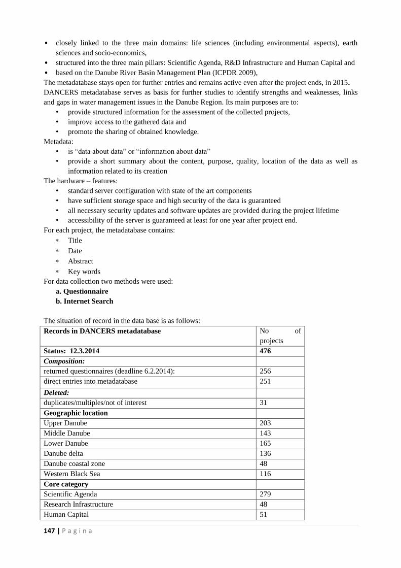
147 | P a g i n a
• closely linked to the three main domains: life sciences (including environmental aspects), earth
sciences and socio-economics,
• structured into the three main pillars: Scientific Agenda, R&D Infrastructure and Human Capital and
• based on the Danube River Basin Management Plan (ICPDR 2009),
The metadatabase stays open for further entries and remains active even after the project ends, in 2015.
DANCERS metadatabase serves as basis for further studies to identify strengths and weaknesses, links
and gaps in water management issues in the Danube Region. Its main purposes are to:
• provide structured information for the assessment of the collected projects,
• improve access to the gathered data and
• promote the sharing of obtained knowledge.
Metadata:
• is “data about data” or “information about data”
• provide a short summary about the content, purpose, quality, location of the data as well as
information related to its creation
The hardware – features:
• standard server configuration with state of the art components
• have sufficient storage space and high security of the data is guaranteed
• all necessary security updates and software updates are provided during the project lifetime
• accessibility of the server is guaranteed at least for one year after project end.
For each project, the metadatabase contains:
Title
Date
Abstract
Key words
For data collection two methods were used:
a. Questionnaire
b. Internet Search
The situation of record in the data base is as follows:
Records in DANCERS metadatabase No of
projects
Status: 12.3.2014 476
Composition:
returned questionnaires (deadline 6.2.2014): 256
direct entries into metadatabase 251
Deleted:
duplicates/multiples/not of interest 31
Geographic location
Upper Danube 203
Middle Danube 143
Lower Danube 165
Danube delta 136
Danube coastal zone 48
Western Black Sea 116
Core category
Scientific Agenda 279
Research Infrastructure 48
Human Capital 51
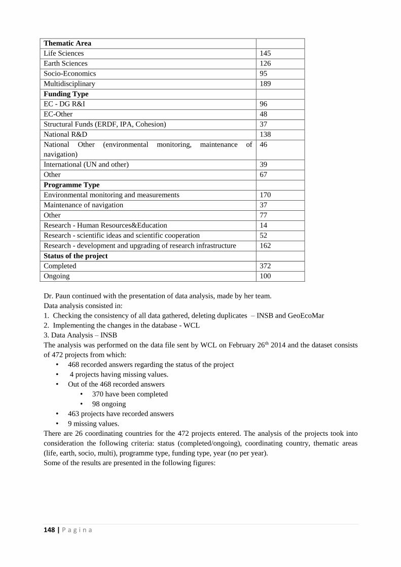
148 | P a g i n a
Thematic Area
Life Sciences 145
Earth Sciences 126
Socio-Economics 95
Multidisciplinary 189
Funding Type
EC - DG R&I 96
EC-Other 48
Structural Funds (ERDF, IPA, Cohesion) 37
National R&D 138
National Other (environmental monitoring, maintenance of
navigation)
46
International (UN and other) 39
Other 67
Programme Type
Environmental monitoring and measurements 170
Maintenance of navigation 37
Other 77
Research - Human Resources&Education 14
Research - scientific ideas and scientific cooperation 52
Research - development and upgrading of research infrastructure 162
Status of the project
Completed 372
Ongoing 100
Dr. Paun continued with the presentation of data analysis, made by her team.
Data analysis consisted in:
1. Checking the consistency of all data gathered, deleting duplicates – INSB and GeoEcoMar
2. Implementing the changes in the database - WCL
3. Data Analysis – INSB
The analysis was performed on the data file sent by WCL on February 26th 2014 and the dataset consists
of 472 projects from which:
• 468 recorded answers regarding the status of the project
• 4 projects having missing values.
• Out of the 468 recorded answers
• 370 have been completed
• 98 ongoing
• 463 projects have recorded answers
• 9 missing values.
There are 26 coordinating countries for the 472 projects entered. The analysis of the projects took into
consideration the following criteria: status (completed/ongoing), coordinating country, thematic areas
(life, earth, socio, multi), programme type, funding type, year (no per year).
Some of the results are presented in the following figures:
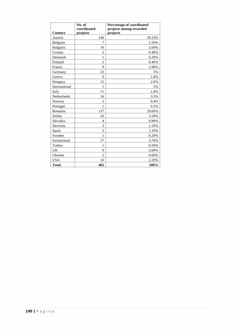
149 | P a g i n a
Country
No. of
coordinated
projects
Percentage of coordinated
projects among recorded
projects
Austria 140 30.23%
Belgium 7 1.50%
Bulgaria 16 2.60%
Croatia 2 0.40%
Denmark 1 0.20%
Finland 2 0.40%
France 9 1.90%
Germany 23 5%
Greece 9 1.9%
Hungary 12 2.6%
International 1 2%
Italy 11 2.4%
Netherlands 16 3.5%
Norway 2 0.4%
Portugal 1 0.2%
Romania 137 29.60%
Serbia 16 3.50%
Slovakia 4 0.90%
Slovenia 5 1.10%
Spain 5 1.10%
Sweden 1 0.20%
Switzerland 17 3.70%
Turkey 1 0.20%
UK 9 2.60%
Ukraine 3 0.60%
USA 10 2.20%
Total 463 100%

150 | P a g i n a
At the end, some conclusions were formulated:
3. Database represents a major contribution to the scientific community and is active, new
information is still added – 4 observations in the last two weeks;
4. There is a significant larger number of projects entered from Austria, Romania, Germany and
Switzerland;
Are there no other projects than the ones entered for the other countries? Or should efforts be made to
have the remaining projects entered for these countries?
3. After the National funding type, the second major funding type is EC DG R&I;
4. Largest number of projects funded in Life Sciences, followed by Earth Sciences; Life Sciences and
Earth Sciences are depended choices for funded projects;
5. From 1976 to 1994 there is no identifiable trend – either due to lack of funding or lack of information
now about the projects funded during that time.
6. An increasing trend in funding from 1994 to an all time high in 2009, with a drop in the number of
funded projects in the next 4 years.
7. Only 21% of the total number of projects that have been identified are active, hence the new strategies
should help improve these numbers;
8. Not enough information about the output of the projects – work in progress.
Following the presentation some comments were made:
C1: The merit of the project is that its database represents a step forward in terms of information in the
Danube Region.
C2: The terminology of the questionnaire is not the best, to encourage people to participate, use: ex.
‘Upload your project’.
C3: Make clean pies for the projects that interconnect for the projects that don’t.
Country Ongoing (1) Completed (2)
Austria 34 104
Belgium 0 7
Bulgaria 4 12
Croatia 0 2
Denmark 0 1
Finland 0 2
France 2 7
Germany 3 20
Greece 2 7
Hungary 4 7
International 0 1
Italy 5 6
Netherlands 5 11
Norway 1 1
Portugal 1 0
Romania 13 124
Serbia 4 12
Slovakia 1 3
Slovenia 1 4
Spain 4 1
Sweden 0 1
Switzerland 4 13
Turkey 0 1
UK 2 10
Ukraine 3 0
USA 3 7
Total 96 364
151 | P a g i n a
6. Introduction to the workshop. Methods and programme
Dr. Panagiotis Michalopoulos, from the Hellenic Centre of Marine Research presented briefly the
purpose of the workshop. The analysis performed on the projects from the data base were presented
critically to the representatives of the business community and discussed critically. The main objectives
are:
• To present results to business reprezentatives and discuss them critically.
• To help the identification of strengths, weaknesses, opportunities and threats in research and
integrated management in the Danube river-Black sea macrosystem .
• To provide input toward:
o Developing a regional science and innovation agenda in the Danube – Danube Delta –
Black Sea.
o Drafting detailed plans for the development of regional distributed research
infrastructures, covering all aspects of environmental sciences.
o Designing an education program aiming at strengthening the human capital in the field of
an innovative integrated management for the Danube – Danube Delta – Black Sea
macrosystem.
In order to achieve the objectives, the approach is to use group discussions with the aid of Questionnaires
to help identify:
• Thematic priorities for a research agenda
• Best future approaches to education in the fields of ecosystem research and management for the
Danube – Danube Delta – Black Sea macrosystem.
• Areas of activity, and potential contribution of a distributed research infrastracture to the
advancement of research, education, planning in the Danube – Danube Delta – Black Sea
macrosystem.
The participants were asked to fill in a ‘Thematic Priorities Questionnaire’.
The questionnaire has three main sections:
a) Thematic Priorities related to Horizon 2020 Societal Challenges
b) Thematic Priorities related to the Danube Ecosystem as a whole and its services.
c) Thematic Priorities Related to Water Issues in the Danube Region.
Participants were asked to fill in an ‘Educational Priorities Questionnaire’.
Participants were asked to fill in a ‘Research Infrastructure Priorities Questionnaire’.
Several comments were made related to the Thematic Priorities Questionnaire:
C1 (from a representative of the science community): Is there a disconnection between what EU proposes
and business needs in terms of thematic priorities? Do you actually need this from the scientific (agenda)
community?
A: Not really, it depends mostly on country and region, some of the points are of interest for the business
community.
C2: The questions are too general, maybe would be better to adapt them on country and region (for
example, coastal issues are rather regional, local).
C3: Stakeholders manage the Danube Region by region/country, keeping in mind that it should be seen
as a system.
C4: A Better management of the system means to come up with solutions – make innovation – ask how
we can use the system to solve the problem.
C5: How to do more with less money - combine efforts from the countries of the Danube Region to
achieve something for the entire macrosystem.
C6: Find economic and political solution to these problems in addition to technical solutions.
C7: For each of the identify issues on the scientific agenda create databases per region/system (ex. Maps
for soil as a resource, state of conservation, etc.)
152 | P a g i n a
A general comment: Put in parallel for a specific question, the answers from the scientist and the business
community and make comparisons.
The group discussions for each of the questionnaire continued the next day – 20.03.2014.
The discussions continued, on the results of the questionnaires. For the ‘thematic priorities’ questionnaire
the results were observed in parallel, the inputs from the scientists and the business community (file to be
sent separately – in the following phase).
Some comments were made:
C1: the terminology in the questionnaires is not very familiar to people from the business community (in
general) and should be adapted.
C2: What people in business would like to see in the questionnaires? Why would they reply?
A: they would replay have on overview of the opportunities in the future. Suggestion: Short description
of the purpose of the questionnaire at the beginning would be very welcomed and would make clearer the
purpose of the questionnaires.
C3: Go online with the questionnaire – simplify, put it on the DANCERS site, for example.
Then, the participants were given time to complete the other questionnaires, on ‘Education Agenda’ and
‘Research Infrastructures’. The results (their answers and the proposed topics to be added to the
questionnaires) are to be communicated.
The meeting ended on Thursday, 20.03.2014.
Annex 1. List of participants:
Name Country Organization
Eva Kopataki
Hungary Aquaprofit
Attila Korcsog
Hungary Aquaprofit
János A. Szabó
Hungary Aquaprofit
Virgil Dinulescu
Romania FMMC
Madalin Ionita
Romania FMMC
Viorel Gh. Ungureanu
viorel.ungureanu@marine-
research.ro
Romania Marine Research Ltd.
Alexandru Dan Ionescu
Romania Marine Research Ltd.
Istvan Gabor Hungary MTA CSFK FGI
Balazs Trasy Hungary ECTE TTK
Francesco Marabini
Italy ISMAR
Jeremy Gault
Ireland University College Cork
Gilles Lericolais
France IFREMER
153 | P a g i n a
Jeanne Gherardi
France IFREMER
Jean – Francois Masset
France IFREMER
Vangelis Papathanassiou
Grece Hellenic Centre for Marine
Research
Robert Devoy
Ireland UCC
Panagiotis Michalopoulos
Grece Hellenic Centre for Marine
Research
Olivera ĐURIČIĆ
Serbia University of Novi Sad
Andrew Tyler
United Kingdom University of Stirling
Chris Bradley
United Kingdom University of Birmingham
Georg Umgiesser
Italy ISMAR
Gretchen Gettel
Holland UNESCO - IHE
Janusz Dominik
Switzerland Univ. Geneva
Nicolai Berlinski
Ukraine Research Centre Noosphera
Bulla Miklos
Hungary University Istvan Szecheny of
Gyor
Jos Brils
Netherlands DELTARES
Alexandra Vancea
Romania MEN
Manuela Sidoroff
Romania INSB
Simona Litescu
Romania INSB
Mihaela Paun
Romania INSB
Andrei Paun
Romania INSB
Gheorghe Oaie
Romania GeoEcoMar
Adriana Constantinescu
Romania GeoEcoMar
Cristian Cudalbu
Romania GeoEcoMar
Madalina Nailia Romania GeoEcoMar
154 | P a g i n a
Adrian Stanica
Romania GeoEcoMar
Annex 2. Agenda of the meeting
19 / 20 March 2014
Venue: HOTEL HOWARD JOHNSON – Calea Dorobantilor nr. 5-7, Sector 1, Bucharest
Wednesday 19 March 2014
09.30 –10.00 Registration of participants
10.00 -10.10 Welcome addresses
Adrian Stanica, Scientific Director of GeoEcoMar
Introduction of participants
Tour de table
10.10 -10.35 New Research and Innovation oportunities provided by the Horizon 2020
Programme in the Danube Region
Alexandra Vancea, Marie Curie Coordinator – Ministry of National Education – Activity
of Research
10.35 -10.50 Presentation of FP 7 DANCERS Project
Adrian Stănică – project coordinator (RO)
10.50 -11.20 Presentation of the DANCERS Data Base of Projects
Mihaela Păun, NISB
11.20 – 11.50 Coffee break
11.50 – 12.20 Opportunities for European Cooperation within Horizon 2020 – Societal Challenge
5 on Integrated Management of River- Delta – Sea Systems (Life Sciences, Earth
Sciences, Environmental Sciences, Water Cycle)
Adrian Stanica, project coordinator on behalf of Christos Fragakis, EC Officer, DG
Research and Innovation
12.20 – 12.40 Introduction to the workshop. Methods and programme
Moderator: Panagiotis Michalopoulos, HCMR
Adrian Stănică – project coordinator (RO)
12.40 – 13.00 Group discussion of state of research in the Danube Region.
Participants will be asked to analyse this in terms of businesses (opportunities):
What is strong
What appears to be missing
155 | P a g i n a
What should be strengthened
By taking into account: domain / geographic distribution / field of interest
13.00 – 14.00 Working lunch
14.00 – 15.30 Mapping of existing projects in Danube Area.
15.30 – 16.00 Coffee break
16.00 – 17.00 Development of a successful research & innovation agenda in the Danube – Black Sea
Region (as support for innovative businesses in this area)
Group discussions
17.00 – 18.00 Medium and long term needs on human resources (education programs) in the field
of water management and research in the Danube – Black Sea Region
Group discussions
19.00 – 21.30 Working dinner.
Thursday 20 March 2014
09.00 - 09.10 Welcome and agenda of the day
Adrian Stănică, GeoEcoMar
09.10 – 10.10 Ideas of a new distributed Research Infrastructure in the field of water
management and research in the Danube – Black Sea Region, in support of
businesses.
Group discussions
10.10 – 10.40 Coffee break
10.40 - 12.00 Conclusions of the Workshop
All partners
12.30 – 14.00 Joint lunch

156 | P a g i n a
7.4. Atelierul International: „Suport stiintific in luarea de decizii in managementul apei din
Regiunea Dunarii” 25-26.05.2014
7.4.1. Annex 5 – Minuta intalnirii
1. Welcome and introduction
The meeting began with the welcoming address of Dr. Gheorghe Oaie, the General Director of
GeoEcoMar. He showed the importance of the two major projects in the Danube Region,
DANUBIUS – RI and DANCERS, their links and convergent points, as DANCERS will create a
solid scientific base and will gather important information that will be used in DANUBIUS – RI
project.
Ms. Viorel Vulturescu, Director of the Directorate Programs for European and International RDI
Priorities, Ministry of National Education, followed, with an introductory address.
The chairman of the Workshop, Martin Felix Gajdusek, introduced the purpose of the meeting –
establishing dialog with the decision makers from the Danube Region and gathering their
opinions on scientific activities that support their needs and activity. The instruments were then
presented, plenary rounds on specific topics (that will be presented and detailed thereafter),
working in groups and filing a questionnaire until the end of the meeting (see Questionnaire in
Annex…..).
2. Introduction to DANCERS project
Dr. Adrian Stanica, introduced the project DANCERS - "DANube macroregion: Capacity
building and Excellence in River Systems (basin, delta and sea)“. The main aim of the project is
to develop new instruments and tools that will enhance environmental research and promote innovation
in Danube Region, including the Danube Delta and the Black Sea. The new instruments and tools do not
start ab initio but will build on existing projects and expertise. The project will analyze the achievements
in the integrated management of the river-delta-sea management in the Danube Region, to understand the
links between the results and the work performed and to define a set of instruments to enhance
environmental research and innovation in the Danube Region. The project consortium comprises
institution from 5 countries from the Danube Region (Germany, Austria, Hungary, Serbia and Romania)
and from the EU (France, Greece, Ireland, Italy, Spain, UK) and UNESCO-IHE.
DANCERS looks at three main areas: science, human potential and research infrastructure from the
perspective of scientist and academia, decision and policy makers and business community. Thus, the
project will establish a competitive research agenda for the Danube Region, to use it later as a model for
river- delta-sea systems worldwide.
3. Results from DANCERS meta database of Projects, Programmes and Initiatives in
the management of river-delta-sea in the Danube Region
The metadatabase of the project was presented by Eva Feldbacher, from Wassercluster Lunz,
AUSTRIA. The objective of the DANCERS database was to gather all existing information
about the projects and their results, regarding water management results in the Danube Region
over the last 20 years. Their analysis allowed for the identification of strengths and weaknesses,
links and gaps in water management issues in the Danube Region. Furthermore, the database
provides easy access to collected data and promotes the sharing of obtained knowledge.
157 | P a g i n a
The metadatabase comprises information about the person who entered a record (date, author,
contact, id) and about the project depicted (title, date, abstract, descriptive keywords). Most of
the data entered was provided via the internet questionnaire at http://wcl-
geo.boku.ac.at/geonetwork/srv/eng/search. The metadatabase stays open for further entries
and will remain active after the project end in 2015.
The data entered in the database was analysed, and the results were presented by Dr. Mihaela
Paun, from the Romanian Institute for Biological Sciences.
The results reveal that, out of 468 recorded answers, 370 projects are completed and 98 are
ongoing. There are 26 coordinating countries, from which Austria and Romania are leading,
with 30 % each, of the projects in the Danube Region. Regarding their thematic area, most of the
projects were multidisciplinary, but many included both life and earth sciences, or life sciences
and socio-economics. Around 36% of the projects were carried out in the ‘research –
development and upgrading the existing infrastructures’ programme, while ~32 % of the
projects had as main objective environmental monitoring and measurements. Maintenance of
navigation and scientific cooperation were each represented in over ~7% of the projects. The
projects concerned with human resources and education only represented 0.6 % of the entered
data. Regarding the funding type, 30% of the projects in the DANCERS data base, were funded
by national R&D funds, ~20% from EC-DGRI funds, ~10% from EC-otherDG’s, and the rest
from other national or international funding programmes.
The data base is a major contribution to the scientific community and is still active, but it lacks
input, especially from the other countries of the Danube Region, that are not DANCERS
members.
4. Introduction to DANCERS questionnaire (model in Annex 3)
In order to gather relevant data from three categories targeted, scientists, business and policy
makers, a questionnaire was developed. Dr. Panagiotis Michalopoulos presented the
questionnaire to the policy makers present at the workshop. The questionnaire will seek the
opinions of stakeholders in order to help shape the priorities of R&I agenda in the Danube
Region and will give input for the formulation of concrete proposals on research priorities,
education and research infrastructures.
The questionnaire represents a tool to build on a critical analysis on the state of the art of the
Danube – Black Sea macrosystem. It makes reference to Horizon 2020, the EU’s framework
programme for R&I, which implements Europe’s flagship initiative aimed at securing Europe’s
global competitiveness. The questions reflect the Societal Challenges – the policy priorities
addressing the major concerns of citizens across Europe, but with a focus on the Danube
macroregion. The questions are the same, for the three main stakeholders, scientists, business
community and policy makers, thus facilitating the direct comparisons of answers. The
questionnaire also allows for the direct comparison of answers across geographic regions and
sectors of activity and for their quantitative assessment.
The questionnaire will be placed online, and other representatives of the three target categories
are invited to answer.
158 | P a g i n a
5. Plenary discussion: how and in which fields does research currently contribute to
public water management challenges in the Danube Region? What is the
experience? What is missing?
The participants were invited to discuss on the questioned addressed. The results of the
discussion revealed that:
Experience of Croatia – scientific research and water quality assessment is done by
universities
The system of financing for the projects in EU countries is different, there are
projects of fundamental research or applied research, so the focus on the application
that these projects have for the stakeholders and policy makers, should represent
research for good practise.
Experience of Germany – the federal ministry for research has special programmes,
but there are also those from the land ministries (regional level)
Experience of Romania:
o regarding the water infrastructure – research results and technology are
needed to develop the actual infrastructure and these new technologies should
be connected with the end-users, to implement new standards, develop new
services to improve navigation on the Danube for ex.
o The implementation of the water framework directive raised some problems
and the authorities could not find the scientific capacity to solve it, the same
happened with the marine strategy, particularly in the open sea area. They
usually need a straight answer in a limited time span but the general answer is
“more research is needed”.
Experience of Serbia – the academia and end-users view a problem in different ways,
so sometimes the call for funding is not in agreement with the true needs. To find the
link between the two categories and increase interaction in discussion and meetings
is needed.
Experience of Moldavia – there is a need for developing new criteria and
methodology for monitoring water quality. Involving general public in water quality
assessment is very useful for general education.
Experience of Bulgaria – there are already scientific results that can be used to
upgrade the current policies.
+Other results (to be completed)
6. Danube River Basin: current activities to identify water management challenges in
the region
The presentation was delivered by Mr Felix Martin Gajdusek – summary from Felix
7. Sharing experience: Improving water management in Moldova
Mrs Irina Coseru, from the National environmental Centre of the Republic of Moldova shared
same of their experience in integrated management of water resources in Moldova. The main
problems are related to water quality, as many of the rivers in Moldova are polluted by industrial
activities and some of the water is used for irrigation, directly from the polluted rivers. Another
problem is the diminished capacity of wastewater treatment plants, so a fraction of the used
water is discharged directly in the surface waters. Many projects are carried out for the
159 | P a g i n a
ecological rehabilitation of the rivers, the water quality and biological status are monitored
constantly. An important part is played by local communities and general public that was
involved in this project, with the aim of raising awareness on the benefits of clean waters and
healthy landscapes and of the dangers of pollution and contamination of drinking water.
8. Interactive working session in three groups on:
Information needs of public authorities
o Perform obligations under EU directives – methods, indexes to evaluate the
status of water bodies, hazards and risks
o Solutions for practical questions
o Integration between different management bodies
o Integrating data bases, even in a transboundary way
o Practical information on current scientific activities – ex DREAM and
DANUBIUS
o Forecast (water level) mid and long term
o Morphological changes
Potential contribution of research in support of public authorities
o RISSS – R&I strategies for smart specialisation
o Modelling
o Improved observations and assessment methods
o Risk assessment
+Results (to be completed)
9. The role of research in the current PA 5 developments (EUSDR PA 5: ’To manage
environmental risks’)
The presentation was delivered by Peter Bakonyi, former PA 5 coordinator. He presented the
PA 5 targets and the actions planned for each of the targets:
Implement Danube wide flood risk management plans - due in 2015 under the Floods
Directive – to include significant reduction of flood risk by 2021, also taking into account
potential impacts of climate change;
o Action: “To develop and adopt one single overarching flood management plan at
basin level”
o Action: “To support wetland and floodplain restoration as an effective mean of
enhancing flood protection (use of “green infrastructure”)”.
o Action: “To extend the coverage of the European Floods Alert System (EFAS)
system to the whole Danube river basin”
o Action: “To strengthen operational cooperation among the emergency response
authorities in the Danube countries and to improve the interoperability of the
available assets”
Update of the Accidental Risk Spots inventory at the Danube River Basin level by 2013;
o Action: "To continuously update the existing database of accident risk spots (ARS
Inventory), contaminated sites and sites used for the storage of dangerous
substances”
160 | P a g i n a
o Action: “To develop rapid response procedures and plans in case of industrial
accidental river pollution
To address the challenges of water scarcity and droughts based on the 2013 update of the
Danube Basin Analysis and the ongoing work in the field of climate adaptation, in the
Danube River Basin Management Plan to be adopted by 2015
o Action: “Anticipate regional and local impacts of climate change through research”.
o Action: “To develop spatial planning and construction activities in the context of
climate change and increased threats of floods”.
These targets and actions are in accordance and hence supported by some of the European
Directives, and involve ICPDR and national ministries through national projects.
Questions followed:
Q1: Any of the research projects mentioned had results that were actually used? Is the socio-economic
part important?
A1: They are at the beginning of the process of 3 years, with no money for investment. They used the
projects already running and the output of the projects will be used for further development to develop
the Priority Areas. The socio-economic side is not yet included.
Q2: Do you have an internal working group.
A2: No predefined governance of the PA exists, but they have a steering group, with members of the 14
countries members of the Danube Region.
Q3: How much is the sea taken into account?
A3: Action1- for coastal zone, river-Black Sea interaction is in PA4 and flooding in PA 5.
10. Interactive working session in two groups on:
improving interaction between science and administration – limits and
challenges, current strengths and weaknesses
Results (to be completed)
11. Overview of the current initiatives and coordination projects across the Danube –
Black Sea system: the role and perspective for research
Presentation missing – summary from Felix
12. Hrvatske Vode – Croatia
Miroslav Matkovic was invited to deliver a presentation on Hrvatske Vode, a legal entity that
manages water and public water estate as well as protective and hydro-ameliorative water
structures in the Republic of Croatia. Hrvatske vode is a non-budgetary fund which redistributes
and allocates as a part of the GDP (water charges and a part of budgetary funds) to water
regulation, protection from adverse effects of water as well as to municipality users through
water supply, sewerage and wastewater treatment projects. As distinguished from budgetary
funding, Hrvatske vode offers direct expert, technical, economic and legal assistance to
municipal users in defining, preparing and implementing projects of varying complexity.
Hrvestke vode uses allocated funds through water management plans, whereas the annual
revenues and expenditures plan needs approvement of the Parliament of the Republic of
Croatia. They made a guide on the restoration of rivers that is available online.
13. Common strategy for sustainable territorial development of the cross-border area
Romania-Bulgaria (CBC project SPATIA)
161 | P a g i n a
Pavel Milenov from the Remote Sensing Applications Center (ReSAC) presented briefly the
elements of this project, focusing on a common territorial data base and preparing complementary
instruments for territorial monitoring and development. The objective of the project is to provide
a comprehensive and accurate overview of the social, economic and territorial condition and the
evolution of the Romania-Bulgaria cross-border area between 2009-2015. The Romanian and
Bulgarian partners aim to develop a comprehensive spatial database that follows the INSPIRE
principles, for the cross-border area and for the elaboration of common strategy for sustainable
territorial development and form monitoring the impact of national and EU policies. The first
result presented was the mapping of Giurgiu – Ruse area, on the Lower Danube. One of the
outcomes of the project may be upgrading this data base for flood risk zones and cultural
heritage.
Other planned initiatives at trans-national level are:
Support to the trans-border/national cooperation BG-RO, BG-FYROM, BG-SR, BG-GR, and
in the future SEE in general
Establishment of a mechanism for regular EO monitoring and changes detection for SEE
region (The European Network of Regional Centers Initiative)
Technical and methodological support to the Regional Center for Lower Danube in
Euroregion Ruse/Giurgiu
Possible joint activities with Austria and pilot studies within EAGLE group
Possible joint activities with Germany (Baden-Wuerttenberg and Bavaria)
14. Interactive working session on
Indicators for significant action R-Agenda & Training Education
………..
Results (to be completed)
Annex 1 – Agenda of the meeting
Agenda
Workshop with policy makers, decision makers and administrations
26 - 27 May 201
Venue: Hotel Howard Johnson, Calea Dorobantilor nr. 5-7, Sector 1, Bucharest
Monday 26 May 2014
14:00 – 14:20 Welcome addresses
Gheorghe Oaie, General Director of GeoEcoMar
Viorel Vulturescu, Director, Programs for European and International RDI Priorities
Directorate, Ministry of National Education
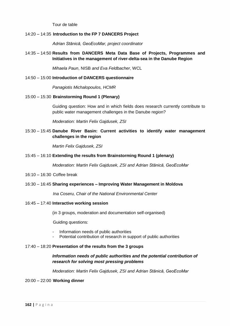
162 | P a g i n a
Tour de table
14:20 – 14:35 Introduction to the FP 7 DANCERS Project
Adrian Stănică, GeoEcoMar, project coordinator
14:35 – 14:50 Results from DANCERS Meta Data Base of Projects, Programmes and
Initiatives in the management of river-delta-sea in the Danube Region
Mihaela Paun, NISB and Eva Feldbacher, WCL
14:50 – 15:00 Introduction of DANCERS questionnaire
Panagiotis Michalopoulos, HCMR
15:00 – 15:30 Brainstorming Round 1 (Plenary)
Guiding question: How and in which fields does research currently contribute to
public water management challenges in the Danube region?
Moderation: Martin Felix Gajdusek, ZSI
15:30 – 15:45 Danube River Basin: Current activities to identify water management
challenges in the region
Martin Felix Gajdusek, ZSI
15:45 – 16:10 Extending the results from Brainstorming Round 1 (plenary)
Moderation: Martin Felix Gajdusek, ZSI and Adrian Stănică, GeoEcoMar
16:10 – 16:30 Coffee break
16:30 – 16:45 Sharing experiences – Improving Water Management in Moldova
Ina Coseru, Chair of the National Environmental Center
16:45 – 17:40 Interactive working session
(in 3 groups, moderation and documentation self-organised)
Guiding questions:
- Information needs of public authorities - Potential contribution of research in support of public authorities
17:40 – 18:20 Presentation of the results from the 3 groups
Information needs of public authorities and the potential contribution of
research for solving most pressing problems
Moderation: Martin Felix Gajdusek, ZSI and Adrian Stănică, GeoEcoMar
20:00 – 22:00 Working dinner
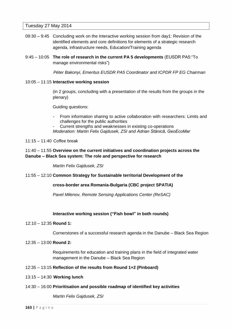
163 | P a g i n a
Tuesday 27 May 2014
09:30 – 9:45 Concluding work on the Interactive working session from day1: Revision of the
identified elements and core definitions for elements of a strategic research
agenda, infrastructure needs, Education/Training agenda
9:45 – 10:05 The role of research in the current PA 5 developments (EUSDR PA5:“To
manage environmental risks”)
Péter Bakonyi, Emeritus EUSDR PA5 Coordinator and ICPDR FP EG Chairman
10:05 – 11:15 Interactive working session
(in 2 groups, concluding with a presentation of the results from the groups in the
plenary)
Guiding questions:
- From information sharing to active collaboration with researchers: Limits and challenges for the public authorities
- Current strengths and weaknesses in existing co-operations Moderation: Martin Felix Gajdusek, ZSI and Adrian Stănică, GeoEcoMar
11:15 – 11:40 Coffee break
11:40 – 11:55 Overview on the current initiatives and coordination projects across the
Danube – Black Sea system: The role and perspective for research
Martin Felix Gajdusek, ZSI
11:55 – 12:10 Common Strategy for Sustainable territorial Development of the
cross-border area Romania-Bulgaria (CBC project SPATIA)
Pavel Milenov, Remote Sensing Applications Center (ReSAC)
Interactive working session (“Fish bowl” in both rounds)
12:10 – 12:35 Round 1:
Cornerstones of a successful research agenda in the Danube – Black Sea Region
12:35 – 13:00 Round 2:
Requirements for education and training plans in the field of integrated water
management in the Danube – Black Sea Region
12:35 – 13:15 Reflection of the results from Round 1+2 (Pinboard)
13:15 – 14:30 Working lunch
14:30 – 16:00 Prioritisation and possible roadmap of identified key activities
Martin Felix Gajdusek, ZSI
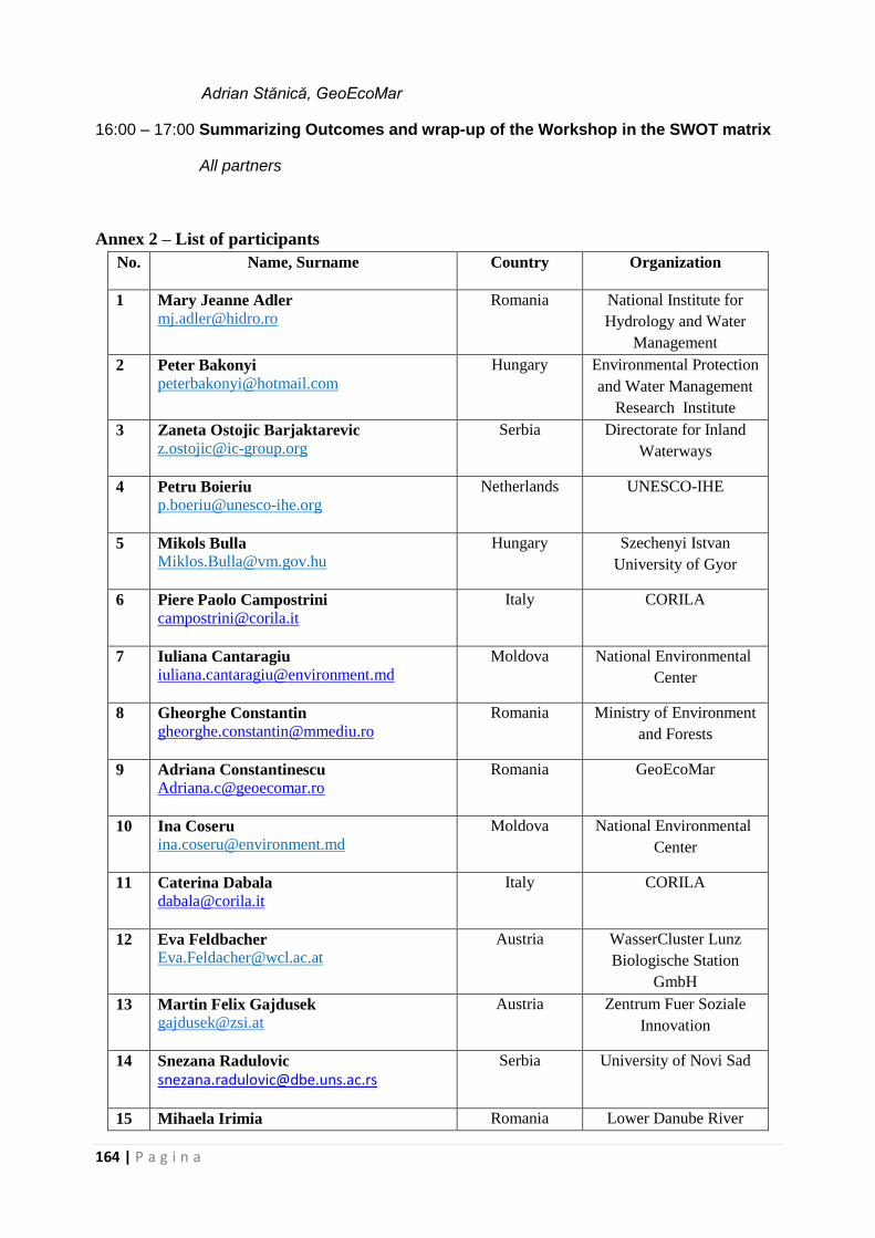
164 | P a g i n a
Adrian Stănică, GeoEcoMar
16:00 – 17:00 Summarizing Outcomes and wrap-up of the Workshop in the SWOT matrix
All partners
Annex 2 – List of participants
No. Name, Surname
Country Organization
1 Mary Jeanne Adler
Romania National Institute for
Hydrology and Water
Management
2 Peter Bakonyi
Hungary Environmental Protection
and Water Management
Research Institute
3 Zaneta Ostojic Barjaktarevic
Serbia Directorate for Inland
Waterways
4 Petru Boieriu
Netherlands UNESCO-IHE
5 Mikols Bulla
Hungary Szechenyi Istvan
University of Gyor
6 Piere Paolo Campostrini
Italy CORILA
7 Iuliana Cantaragiu
Moldova National Environmental
Center
8 Gheorghe Constantin
Romania Ministry of Environment
and Forests
9 Adriana Constantinescu
Romania GeoEcoMar
10 Ina Coseru
Moldova National Environmental
Center
11 Caterina Dabala
Italy CORILA
12 Eva Feldbacher
Austria WasserCluster Lunz
Biologische Station
GmbH
13 Martin Felix Gajdusek
Austria Zentrum Fuer Soziale
Innovation
14 Snezana Radulovic
Serbia University of Novi Sad
15 Mihaela Irimia Romania Lower Danube River
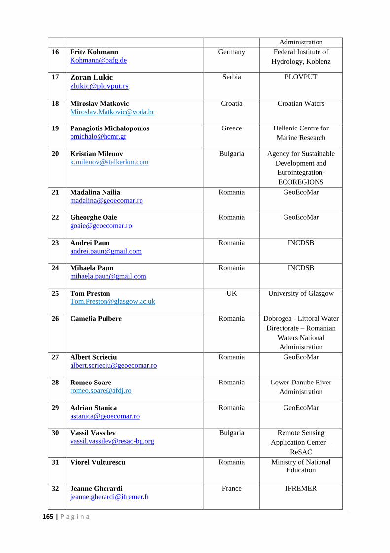
165 | P a g i n a
Administration
16 Fritz Kohmann
Germany Federal Institute of
Hydrology, Koblenz
17 Zoran Lukic
Serbia PLOVPUT
18 Miroslav Matkovic
Croatia Croatian Waters
19 Panagiotis Michalopoulos
Greece Hellenic Centre for
Marine Research
20 Kristian Milenov
Bulgaria Agency for Sustainable
Development and
Eurointegration-
ECOREGIONS
21 Madalina Nailia
Romania GeoEcoMar
22 Gheorghe Oaie
Romania GeoEcoMar
23 Andrei Paun
Romania INCDSB
24 Mihaela Paun
Romania INCDSB
25 Tom Preston
UK University of Glasgow
26 Camelia Pulbere
Romania Dobrogea - Littoral Water
Directorate – Romanian
Waters National
Administration
27 Albert Scrieciu
Romania GeoEcoMar
28 Romeo Soare
Romania Lower Danube River
Administration
29 Adrian Stanica
Romania GeoEcoMar
30 Vassil Vassilev
Bulgaria Remote Sensing
Application Center –
ReSAC
31 Viorel Vulturescu
Romania Ministry of National
Education
32 Jeanne Gherardi
France IFREMER
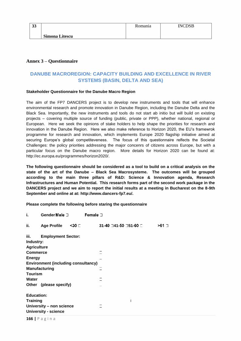
166 | P a g i n a
33
Simona Litescu
Romania INCDSB
Annex 3 – Questionnaire
DANUBE MACROREGION: CAPACITY BUILDING AND EXCELLENCE IN RIVER
SYSTEMS (BASIN, DELTA AND SEA)
Stakeholder Questionnaire for the Danube Macro Region
The aim of the FP7 DANCERS project is to develop new instruments and tools that will enhance
environmental research and promote innovation in Danube Region, including the Danube Delta and the
Black Sea. Importantly, the new instruments and tools do not start ab initio but will build on existing
projects – covering multiple source of funding (public, private or PPP), whether national, regional or
European. Here we seek the opinions of stake holders to help shape the priorities for research and
innovation in the Danube Region. Here we also make reference to Horizon 2020, the EU’s framewrok
programme for research and innovation, which implements Europe 2020 flagship initiative aimed at
securing Europe’s global competiteveness. The focus of this questionnaire relfects the Societal
Challenges: the policy priorities addressing the major concenrs of citizens across Europe, but with a
particular focus on the Danube macro region. More details for Horizon 2020 can be found at:
http://ec.europa.eu/programmes/horizon2020/.
The following questionnaire should be considered as a tool to build on a critical analysis on the
state of the art of the Danube – Black Sea Macrosysteme. The outcomes will be grouped
according to the main three pillars of R&D: Science & Innovation agenda, Research
Infrastructures and Human Potential. This research forms part of the second work package in the
DANCERS project and we aim to report the initial results at a meeting in Bucharest on the 8-9th
September and online at at: http://www.dancers-fp7.eu/.
Please complete the following before staring the questionnaire
i. Gender
ii. Age Profile 31- 41- 51-
iii. Employment Sector:
Industry:
Agriculture
Commerce
Energy
Environment (including consultancy)
Manufacturing
Tourism
Water
Other (please specify)
Education:
Training
University – non science
University - science
167 | P a g i n a
Research & Science:
Government Research Institution
Other (please specify)
Policy Makers:
Local
Regional
National
European
iv. Do the views you are reporting reflect:
- your institution
- you as individual
v. Country in which you are based
Within the Danube Catchment (name) _______________________
Outside the Danube Catchment (name) _______________________
Questionnaire Instructions:
The questionnaire is structured in 4 sections. Please complete sections 1 and 2 and as much of
sections 3 and 4 as you feel suitably qualified to answer.
Section 1 : Infrastructure priorities - Related to Horizon 2020 Societal Challenges in the Danube region
Section 2 : Thematic priorities - The priorities for research to foster sustainable resource use
Section 3 : Business priorities - The challenges and opportunities for sustainable business development
Section 4 : Educational priorities - The educational requirements required to meet the societal challenge
Section 1: INFRASTRUCTURAL PRIORITIES
Related to Horizon 2020 Societal Challenges in the Danube Region
1.1. Do you believe there is a need for a new research center in the field of rivers to sea macro-systems processes at an EU / International level?
Yes No Don’t know
Conditional response:
If Yes to the Q1:
1.1a: Do you believe that a new research infrastructure dedicated to Danube-Black Sea Macrosystem
Processes could be an essential component in international understanding of rivers to sea macro-
systems processes?
Yes No Don’t know
168 | P a g i n a
If No, then briefly explain your response:
1.2 For the Danube Region do you believe this could be achieved by either
a) Upgrading existing infrastructure and transnational communication alone
b) The establishment of a new infrastructure to co-ordinate / focus current efforts?
c) Don’t know `
Conditional response:
If b to the Q2:
Which should be the main priorities for the activities carried out in a new research infrastructure
?
Priority High (7) to Low (1)
7 6 5 4 3 2 1
Education
Fundamental Research
Applied Research/Innovation/ Technology
Observation/ Data gathering and archiving
Experimental Facilities
Expert Analysis/Consultation
Advising on Policy/Regulation
Coordination with other –global-riverine/delta infrastructures
Other (please add):
1.3 Please indicate the themes you consider research priority in the context of the Danube-Balck Sea
Macrosystem . You can add other research priorities in the blank fields.According to your own
expertise.
Themes Rank from High
Priority (1) to Low (9)
Maintaining ecosystem sustainability
Developing safe water systems for citizens
Assessing an managing ecosystem resiliance to environmental change
Hazard Mitigation
Developing Basing-Delta-Sea observation platforms
Promoting competitiveness in the water industry
Implementing a water-wise bio-based economy
169 | P a g i n a
Closing the water cycle gap
Promoting environmental stewardship
1.4. Which of the following do you consider the biggest challenges/risks in the planning and operation of
a new research infrastructure in the Danube region ?
Challenge
High Risk (7) to Low (1)
7 6 5 4 3 2 1
Financial Security/Funding
Organization Structure
Integration with existing infrastructures
Quality of Staff-Facilities/ Appeal to targeted end-users
Defining appropriate thematicareas
Obtaining continuous support/endorsement from
regional/national/international stakeholders
Other (Please add):
1.5 List, in order of priority: a) the barriers (e.g. regulatory, physical, political); and b) opportunities (e.g. funding, cooperative initiatives) to an integrated catchment management system for the Danube Macro Region
Barriers Priority order
Opportunities Priority order
1.6. What technologies or tools are required to overcome these barriers to an integrated catchment
management system for the Danube Macro Region ?
170 | P a g i n a
1.7. What areas for investment should be prioritized to influence the economic development of the Danube Macro Region?
Section 2: THEMATIC PRIORITIES
The priorities for research to foster sustainable resource use
2A : Related to Horizon 2020 Societal Challenges in the Danube Region
Horizon 2020 framework societal challenges will be the guiding principles for the future European
research
2.1. Which are the most relevant scientific areas in terms of societal challenges In the Danube region?
Scientific Areas Very Relevant (7) not relevant (1)
7 6 5 4 3 2 1
SC 1 : Health, demographic change and wellbeing
SC 2 : Food Security, sustainable agriculture, marine and maritime research and the bio-economy
SC 3 : Secure, clean and efficient energy
SC 4: Smart, green and integrated transport
SC 5 :Climate action, resource efficiency and raw materials
SC 6 : Inclusive, innovative and reflective societies
SC 7 : Secure societies to protect freedom and security of Europe and its citizens
2.2. With respect to Societal Challenge 2 (Food Security, sustainable agriculture, marine and maritime research and the bio-economy) which themes are more relevant in the Danube region.
Theme Very Relevant (7) not relevant (1)
7 6 5 4 3 2 1
Sustainable agriculture and forestry
Sustainable and competitive agri-food sector for a safe and healthy diet
Unlocking the potential of aquatic living resources
Sustainable and competitive bio-based industries
2.3 With respect to Societal Challenge 3 (Secure, clean and efficient energy) which themes are more relevant in the Danube region.
Theme Very Relevant (7) not relevant (1)
7 6 5 4 3 2 1
Reducing energy consumption and carbon footprint through smart and sustainable usage
Low-cost, low-carbon electricity supply
Alternative fuels and mobile energy sources
171 | P a g i n a
A single, smart European electricity grid
New knowledge and technologies
Robust decision making and public engagement
Market uptake of energy innovation, empowering markets and consumers
2.4. With respect to Societal Challenge 5 (Climate action, resource efficiency and raw materials) which themes are more relevant in the Danube region
heme Very Relevant (7) not relevant (1)
7 6 5 4 3 2 1
Fighting and adapting to climate change
Sustainably managing natural resources and ecosystems
Ensuring the sustainable supply of non-energy and non-agricultural raw materials
Enabling the transition towards a green economy through eco-innovation
Developing comprehensive and sustained global environmental observation and information systems.
2B : Thematic Priorities Related to the Danube Ecosystem and ecosystem services
2.5. The Millenium Ecosystem Assesment Report has identified the following risks to ecosystem services that are most likely to lead to irreversible downgrading in the future. Please rank them with respect to their importance in the Danube region. Add any other risk you consider appropriate and rate its importance.
Risk to ecosystem services
Very Important (7) not important (1)
7 6 5 4 3 2 1
Water Cycle. Water withdrawals from rivers and lakes for
irrigation or for urban or industrial use, large reservoir
construction.
Carbon Cycle. Changes on ecosystem function as a net
source/sink of CO2 due to afforestation, reforestation and
forest management, degradation of agricultural,
pasture,and forestlands, land use change, changed
agriculture practices, the fertilizing effects of nitrogen
deposition and increasing atmospheric CO2 .
Nitrogen Cycle. Increase in reactive or biologically
available nitrogen due to use of fertilizers and its effects in
terrestrial and marine ecosystems
Phosphorous Cycle. Increased use of phosphorous
fertilizers and other substances, accumulation in
agricultural soils and its effects in terrestrial and marine
ecosystems.
Other (Please add):
172 | P a g i n a
2.6. In the past 50-100 years, the following direct drivers have caused significant changes in terrestrial ecosystem and their services. Based on your expert opinion, rank the most important direct drivers in terrestrial ecosystems of the Danube region likely to cause changes in Ecosystem Services in the future (i.e. next 20 years). Add other direct drivers you may consider relevant.
Drivers: Terrestrial ecosystem Very Important (7) not important (1)
7 6 5 4 3 2 1
Land cover change
New technologies for the provision of food, timber, fiber..
Pollution/nutrient loading
Climate change
Changes in fishing practices
Disruption of the sedimentary regime
Development of extensive “hard” flood protection systems & destruction of wetlands
Other (Please add):
2.7. In the past 50-100 years, the following direct drivers have caused significant changes in freshwater ecosystems and their services. Based on your expert opinion, rank the most important direct drivers in freshwater ecosystems of the Danube region that will cause changes in Ecosystem Services in the future (i.e. next 20 years). Add other drivers you consider relevant.
Drivers: Freshwater Very Important (7) not important (1)
7 6 5 4 3 2 1
Modification of water regimes (from water abstraction /
consumption and uses, hydrotechnical interventions, etc)
Alien species and biodiversity changes / species alteration
Pollution/nutrient loading
Climate change
Environmental accidents
Energy (hydro power)
Fishing and acquaculture
Other (Please add):
2.8 In the past 50-100 years, the following direct drivers have caused significant changes in coastal &
marine ecosystem and their services. Based on your expert opinion, rank the most important
direct drivers in coastal & marine ecosystems of the Danube region that will cause changes in
Ecosystem Services in the future (i.e. next 20 years). Add other drivers you consider relevant.
Drivers: coastal & marine Very Important (7) not important (1)
7 6 5 4 3 2 1
Fishing pressures
Alien species
Land, River,Ocean-based Pollution/Nutrient loading
173 | P a g i n a
Climate change
Habitat Loss/Conversion
Sediment Starvation
Navigation
Flooding
Dams and jetties construction
Biodiversity initiatives – regulations (conventions to which Danube Delta Biosphere Reserve adhered
Tourism
Other (please add):
2.9. Please indicate the importance of the following anthropic influences/ human influences on ecosystem processes in the Danube Region with respect to where the scientific effort should be directed.
Human influences Very Important (7) not important (1)
7 6 5 4 3 2 1
Disease emergence (e.g. flooding due to climate change can cause the spread of edidemics).
Fisheries collapse
Species introductions and losses
Regional climate change
Eutrophication and hypoxia
Legacy and Emerging contaminants
Changes in Agriculture usage
Ecological Restoration
Genetic Pollution
Alteration of Sediment dynamics due to re-modelling
including dams, coastal protection, restoration
Global Climate change Sea level rise
Forestry
Land use change
Other (Please add):
2.10 Please indicate which of the following Provisioning Ecosystem Services are more relevant for the
Danube Region:
Theme Very Relevant (7) not relevant (1)
7 6 5 4 3 2 1
Food
Raw materials for textile industry
Fuel
Genetic resources
Pharmaceutical and natural medicines,
Fresh water
Other (please add):
2.11 Please indicate which of the following Regulating Ecosystem Services are more relevant for the
Danube Region:
Theme Very Relevant (7) not relevant (1)
174 | P a g i n a
7 6 5 4 3 2 1
Air quality maintenance
Climate regulation
Water regulation
Erosion control
Water purification and waste treatment
Regulation of human diseases.
Pollination.
Storm protection.
Other (please add)
2.12 Please indicate which of the following Cultural Ecosystem Services are more relevant for the
Danube Region:
Theme Very Relevant (7) not relevant (1)
7 6 5 4 3 2 1
Cultural diversity
Spiritual and religious values
Knowledge systems (traditional and formal)
Educational values
Inspiration
Aesthetic values
Social relations
Sense of place
Cultural heritage values
Other (please add)
2.13 Please indicate which of the following Supporting Ecosystem Services are more relevant for for the Danube Region
Theme Very Relevant (7) not relevant (1)
7 6 5 4 3 2 1
Soil formation and retention
Nutrient Cycling
Primary Production/ Photosynthesis/Production of Atmospheric Oxygen Gas
Water cycling
Provisioning of habitat
Other (please add):
2.14 Sustainable Ecosystems (monitoring of threats, risk assessment, climate change scenarios) Please identify which fields in each theme described below you consider a priority
Theme High Priority (7) to Low (1)
7 6 5 4 3 2 1
Ecological engineering (restoration of ecosystems, ecosystems resilience characterization)
Ecohydrology (relationships between hydrological processes and biotic dynamic; ecosystem responses)
Managing the effects of hydro climatic extremes on ecosystems (monitoring of drought events and water scarcity; early warning system; water management)
Developing ecosystem services approaches (ecological functionning of ecosystems, economic value assessment of ecosystem services)
Other (please add):
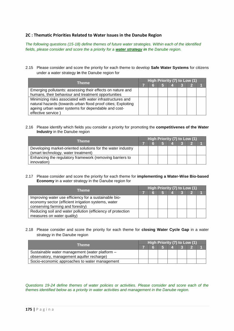
175 | P a g i n a
2C : Thematic Priorities Related to Water Issues in the Danube Region
The following questions (15-18) define themes of future water strategies. Within each of the identified
fields, please consider and score the a priority for a water strategy in the Danube region.
2.15 Please consider and score the priority for each theme to develop Safe Water Systems for citizens
under a water strategy in the Danube region for
Theme High Priority (7) to Low (1)
7 6 5 4 3 2 1
Emerging pollutants: assessing their effects on nature and humans, their behaviour and treatment opportunities
Minimizing risks associated with water infrastructures and natural hazards (towards urban flood proof cities; Exploiting ageing urban water systems for dependable and cost-effective service )
2.16 Please identify which fields you consider a priority for promoting the competitivenes of the Water Industry in the Danube region
Theme High Priority (7) to Low (1)
7 6 5 4 3 2 1
Developing market-oriented solutions for the water industry (smart technology, water treatment)
Enhancing the regulatory framework (removing barriers to innovation)
2.17 Please consider and score the priority for each theme for implementing a Water-Wise Bio-based Economy in a water strategy in the Danube region for
Theme High Priority (7) to Low (1)
7 6 5 4 3 2 1
Improving water use efficiency for a sustainable bio-economy sector (efficient irrigation systems, water conserving farming and forestry)
Reducing soil and water pollution (efficiency of protection measures on water quality)
2.18 Please consider and score the priority for each theme for closing Water Cycle Gap in a water
strategy in the Danube region
Theme High Priority (7) to Low (1)
7 6 5 4 3 2 1
Sustainable water management (water platform – observatory, management aquifer recharge)
Socio-economic approaches to water management
Questions 19-24 define themes of water policies or activities. Please consider and score each of the themes identified below as a priority in water activities and management in the Danube region.
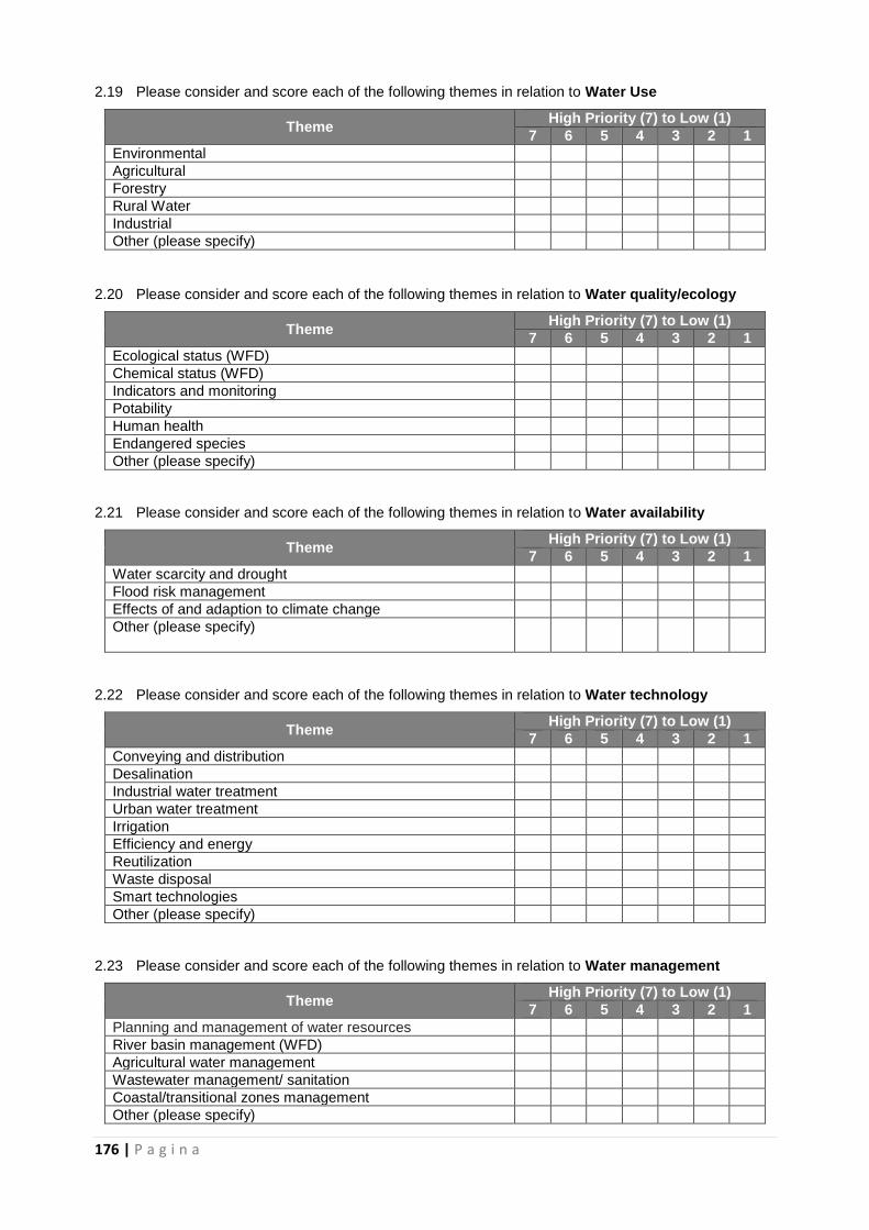
176 | P a g i n a
2.19 Please consider and score each of the following themes in relation to Water Use
Theme High Priority (7) to Low (1)
7 6 5 4 3 2 1
Environmental
Agricultural
Forestry
Rural Water
Industrial
Other (please specify)
2.20 Please consider and score each of the following themes in relation to Water quality/ecology
Theme High Priority (7) to Low (1)
7 6 5 4 3 2 1
Ecological status (WFD)
Chemical status (WFD)
Indicators and monitoring
Potability
Human health
Endangered species
Other (please specify)
2.21 Please consider and score each of the following themes in relation to Water availability
Theme High Priority (7) to Low (1)
7 6 5 4 3 2 1
Water scarcity and drought
Flood risk management
Effects of and adaption to climate change
Other (please specify)
2.22 Please consider and score each of the following themes in relation to Water technology
Theme High Priority (7) to Low (1)
7 6 5 4 3 2 1
Conveying and distribution
Desalination
Industrial water treatment
Urban water treatment
Irrigation
Efficiency and energy
Reutilization
Waste disposal
Smart technologies
Other (please specify)
2.23 Please consider and score each of the following themes in relation to Water management
Theme High Priority (7) to Low (1)
7 6 5 4 3 2 1
Planning and management of water resources
River basin management (WFD)
Agricultural water management
Wastewater management/ sanitation
Coastal/transitional zones management
Other (please specify)
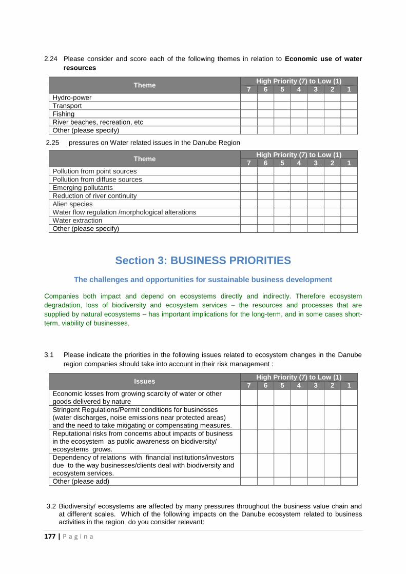
177 | P a g i n a
2.24 Please consider and score each of the following themes in relation to Economic use of water
resources
Theme High Priority (7) to Low (1)
7 6 5 4 3 2 1
Hydro-power
Transport
Fishing
River beaches, recreation, etc
Other (please specify)
2.25 pressures on Water related issues in the Danube Region
Theme High Priority (7) to Low (1)
7 6 5 4 3 2 1
Pollution from point sources
Pollution from diffuse sources
Emerging pollutants
Reduction of river continuity
Alien species
Water flow regulation /morphological alterations
Water extraction
Other (please specify)
Section 3: BUSINESS PRIORITIES
The challenges and opportunities for sustainable business development
Companies both impact and depend on ecosystems directly and indirectly. Therefore ecosystem
degradation, loss of biodiversity and ecosystem services – the resources and processes that are
supplied by natural ecosystems – has important implications for the long-term, and in some cases short-
term, viability of businesses.
3.1 Please indicate the priorities in the following issues related to ecosystem changes in the Danube
region companies should take into account in their risk management :
Issues High Priority (7) to Low (1)
7 6 5 4 3 2 1
Economic losses from growing scarcity of water or other goods delivered by nature
Stringent Regulations/Permit conditions for businesses (water discharges, noise emissions near protected areas) and the need to take mitigating or compensating measures.
Reputational risks from concerns about impacts of business in the ecosystem as public awareness on biodiversity/ ecosystems grows.
Dependency of relations with financial institutions/investors due to the way businesses/clients deal with biodiversity and ecosystem services.
Other (please add)
3.2 Biodiversity/ ecosystems are affected by many pressures throughout the business value chain and at different scales. Which of the following impacts on the Danube ecosystem related to business activities in the region do you consider relevant:
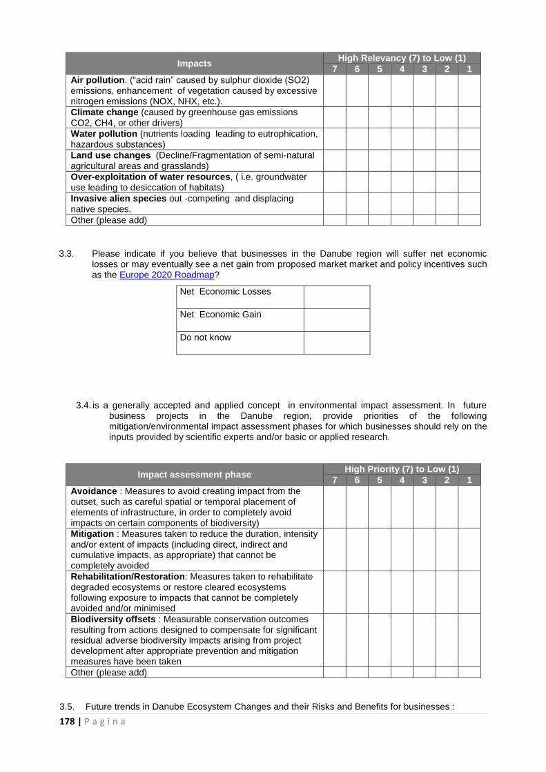
178 | P a g i n a
Impacts High Relevancy (7) to Low (1)
7 6 5 4 3 2 1
Air pollution. (“acid rain” caused by sulphur dioxide (SO2) emissions, enhancement of vegetation caused by excessive nitrogen emissions (NOX, NHX, etc.).
Climate change (caused by greenhouse gas emissions CO2, CH4, or other drivers)
Water pollution (nutrients loading leading to eutrophication, hazardous substances)
Land use changes (Decline/Fragmentation of semi-natural agricultural areas and grasslands)
Over-exploitation of water resources, ( i.e. groundwater use leading to desiccation of habitats)
Invasive alien species out -competing and displacing native species.
Other (please add)
3.3. Please indicate if you believe that businesses in the Danube region will suffer net economic losses or may eventually see a net gain from proposed market market and policy incentives such as the Europe 2020 Roadmap?
Net Economic Losses
Net Economic Gain
Do not know
3.4. is a generally accepted and applied concept in environmental impact assessment. In future business projects in the Danube region, provide priorities of the following mitigation/environmental impact assessment phases for which businesses should rely on the inputs provided by scientific experts and/or basic or applied research.
Impact assessment phase High Priority (7) to Low (1)
7 6 5 4 3 2 1
Avoidance : Measures to avoid creating impact from the outset, such as careful spatial or temporal placement of elements of infrastructure, in order to completely avoid impacts on certain components of biodiversity)
Mitigation : Measures taken to reduce the duration, intensity and/or extent of impacts (including direct, indirect and cumulative impacts, as appropriate) that cannot be completely avoided
Rehabilitation/Restoration: Measures taken to rehabilitate degraded ecosystems or restore cleared ecosystems following exposure to impacts that cannot be completely avoided and/or minimised
Biodiversity offsets : Measurable conservation outcomes resulting from actions designed to compensate for significant residual adverse biodiversity impacts arising from project development after appropriate prevention and mitigation measures have been taken
Other (please add)
3.5. Future trends in Danube Ecosystem Changes and their Risks and Benefits for businesses :
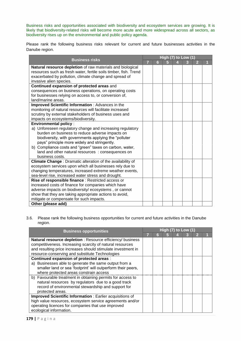
179 | P a g i n a
Business risks and opportunities associated with biodiversity and ecosystem services are growing. It is likely that biodiversity-related risks will become more acute and more widespread across all sectors, as biodiversity rises up on the environmental and public policy agenda. Please rank the following business risks relevant for current and future businesses activities in the
Danube region.
Business risks High (7) to Low (1)
7 6 5 4 3 2 1
Natural resource depletion of raw materials and biological resources such as fresh water, fertile soils timber, fish. Trend exacerbated by pollution, climate change and spread of invasive alien species.
Continued expansion of protected areas and consequences on business operations, on operating costs for businesses relying on access to, or conversion of, land/marine areas.
Improved Scientific Information : Advances in the monitoring of natural resources will facilitate increased scrutiny by external stakeholders of business uses and impacts on ecosystems/biodiversity.
Environmental policy : a) Unforeseen regulatory change and increasing regulatory
burden on business to reduce adverse impacts on biodiversity, with governments applying the “polluter pays” principle more widely and stringently.
b) Compliance costs and “green” taxes on carbon, water, land and other natural resources : consequences on business costs.
Climate Change : Dramatic alteration of the availability of ecosystem services upon which all businesses rely due to changing temperatures, increased extreme weather events, sea-level rise, increased water stress and drought.
Rise of responsible finance : Restricted access or increased costs of finance for companies which have adverse impacts on biodiversity/ ecosystems , or cannot show that they are taking appropriate actions to avoid, mitigate or compensate for such impacts.
Other (please add)
3.6. Please rank the following business opportunities for current and future activities in the Danube region.
Business opportunities High (7) to Low (1)
7 6 5 4 3 2 1
Natural resource depletion : Resource efficiency/ business competitiveness. Increasing scarcity of natural resources and resulting price increases should stimulate investment in resource-conserving and substitute Technologies
Continued expansion of protected areas : a) Businesses able to generate the same output from a
smaller land or sea ‘footprint’ will outperform their peers, where protected areas constrain access
b) Favourable treatment in obtaining permits for access to natural resources by regulators due to a good track record of environmental stewardship and support for protected areas.
Improved Scientific Information : Earlier acquisitions of high value resources, ecosystem service agreements and/or operating licences for companies that use improved ecological information.
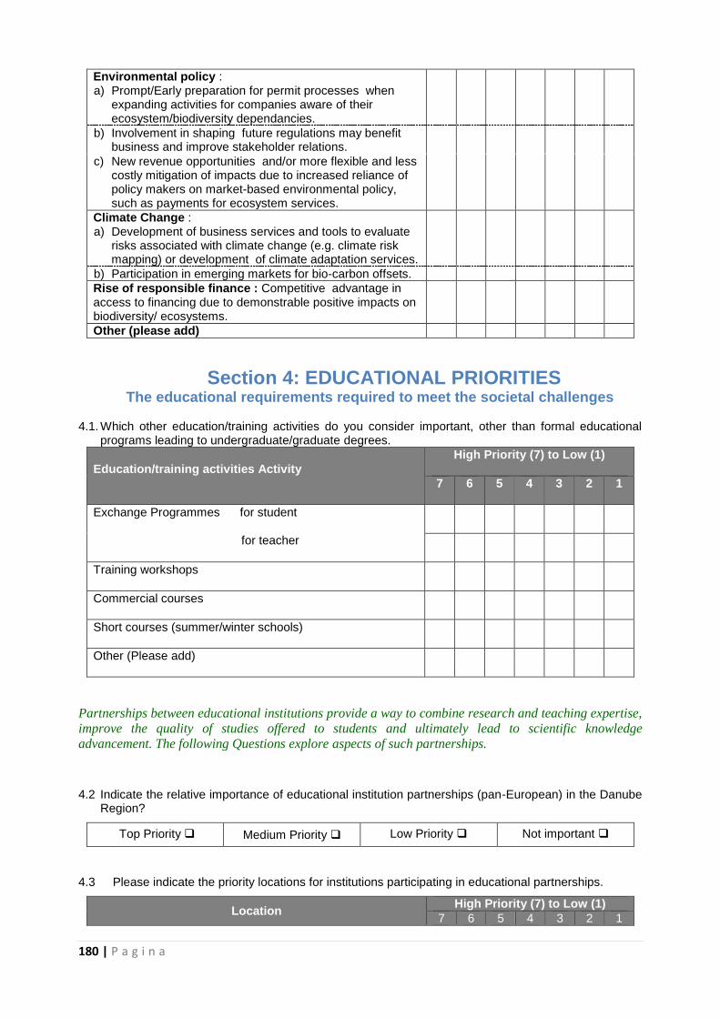
180 | P a g i n a
Environmental policy : a) Prompt/Early preparation for permit processes when
expanding activities for companies aware of their ecosystem/biodiversity dependancies.
b) Involvement in shaping future regulations may benefit business and improve stakeholder relations.
c) New revenue opportunities and/or more flexible and less costly mitigation of impacts due to increased reliance of policy makers on market-based environmental policy, such as payments for ecosystem services.
Climate Change : a) Development of business services and tools to evaluate
risks associated with climate change (e.g. climate risk mapping) or development of climate adaptation services.
b) Participation in emerging markets for bio-carbon offsets.
Rise of responsible finance : Competitive advantage in access to financing due to demonstrable positive impacts on biodiversity/ ecosystems.
Other (please add)
Section 4: EDUCATIONAL PRIORITIES The educational requirements required to meet the societal challenges
4.1. Which other education/training activities do you consider important, other than formal educational programs leading to undergraduate/graduate degrees.
Education/training activities Activity
High Priority (7) to Low (1)
7 6 5 4 3 2 1
Exchange Programmes for student
for teacher
Training workshops
Commercial courses
Short courses (summer/winter schools)
Other (Please add)
Partnerships between educational institutions provide a way to combine research and teaching expertise,
improve the quality of studies offered to students and ultimately lead to scientific knowledge
advancement. The following Questions explore aspects of such partnerships.
4.2 Indicate the relative importance of educational institution partnerships (pan-European) in the Danube Region?
Top Priority Medium Priority Low Priority Not important
4.3 Please indicate the priority locations for institutions participating in educational partnerships.
Location High Priority (7) to Low (1)
7 6 5 4 3 2 1
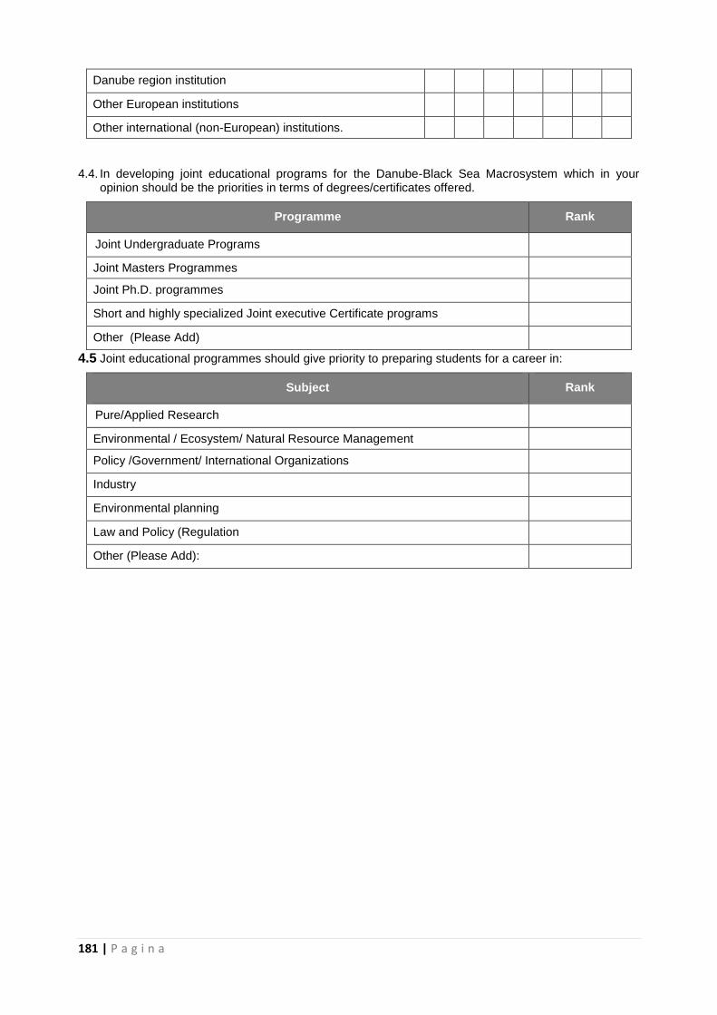
181 | P a g i n a
Danube region institution
Other European institutions
Other international (non-European) institutions.
4.4. In developing joint educational programs for the Danube-Black Sea Macrosystem which in your opinion should be the priorities in terms of degrees/certificates offered.
Programme Rank
Joint Undergraduate Programs
Joint Masters Programmes
Joint Ph.D. programmes
Short and highly specialized Joint executive Certificate programs
Other (Please Add)
4.5 Joint educational programmes should give priority to preparing students for a career in:
Subject Rank
Pure/Applied Research
Environmental / Ecosystem/ Natural Resource Management
Policy /Government/ International Organizations
Industry
Environmental planning
Law and Policy (Regulation
Other (Please Add):
182 | P a g i n a
8. BIBLIOGRAFIE
Website:
http://www.lifewatch.eu/web/guest/home
http://envirogrids.net/
http://www.eurofleets.eu/np4/home.html
http://www.seadatanet.org/
http://www.blackseascene.net/
http://www.east-nmr.eu
http://www.groom-fp7.eu/doku.php
http://www.jpi-oceans.eu/prognett-jpi-oceans/About_us/1253960389448
http://www.jpi-climate.eu
http://www.waterjpi.eu
http://www.sednet.org/
http://www.eurocean.org/np4/60
http://www.rvinfobase.eurocean.org/
http://www.emodnet-physics.eu/
www.geohazard-blacksea.eu
http://www.blacksea-commission.org/
http://www.eu-hermes.net/intro.html
http://ec.europa.eu/maritimeaffairs/policy/sea_basins/black_sea/index_en.htm
http://www.earthobservations.org/geoss_wa_tar.shtml
http://www.earthobservations.org/geoss.shtml
http://www.ioc-goos.org/
http://www.copernicus.eu/
http://ioc-unesco.org/
http://www.iode.org/
http://www.thegef.org/gef/whatisgef
http://www.unep.org/
http://www.iucn.org/about/
http://www.geoecomar.ro/website/nave-cercetare-mare-nigrum.html
http://www.hydralab.eu
http://www.jerico-fp7.eu/
http://www.pegasoproject.eu
http://www.geoecomar.ro/website/nave-cercetare-istros.html
http://www.plancoast.eu/
http://www.globolakes.ac.uk/
http://lagoons.web.ua.pt/
http://www.expeeronline.eu/
http://www.east-nmr.eu
http://www.climatewater.org/project.php
http://public.cranfield.ac.uk/e101732/psi%20connect/documents/d3.2_national_level.pdf
http://www.psiconnect.eu/
http://www.rising.eu/web/guest;jsessionid=54C646109495289362536A502C99A548
http://www.delta-alliance.org/
http://www.euraqua.org/
183 | P a g i n a
http://www.ibiol.ro/man/wkp2009a/Sandu_BIOWETMAN_Feb2009.pdf
http://www.icpdr.org/main/
http://www.icpdr.org/main/activities-projects/dablas
http://www.iad.gs/
http://www.glowa-danube.de/eng/projekt/projekt.php
http://www.alsodanube.at/
http://www.danubeparks.org/
http://7fp.mon.bg/upload/docs/Danube_RDSI_Pilot_Project_Final.pdf
http://www.danube-floodrisk.eu/2009/11/about/
http://www.lter-europe.net/
http://www.wiser.eu/programme/
http://www.icpdr.org/main/publications/million-euro-boat-expedition-test-danube-pollution http://www.ngo.ro/site_item_full.shtml?x=1896
http://www.geoecomar.ro/website/en/nave-cercetare-halmyris.html
http://delta.aerocontrol.ro/Project_Proposal-UAS-BIRDD%20-%20Short%20Version.pdf
http://www.szigetkoz.info/beadott_riportok/07LaymanReport_LIFE04ENVH000382.pdf
http://www.azo.hr/IPA2009CapacityBuildingFor
http://www.donauauen.at/?language=english
http://www.umweltbundesamt.at/en/services/services_resources/services_water/?id=15552
http://www.etc-more.eu/ms/etc_more/more_en/en_theproject/
http://www.orientgateproject.org/index.php?page=partnership
http://wahastrat.vizugy.hu/
http://www.danubecc.org/upl/TRANSDANUBE_leaflet_EN.pd
http://www.seeriskproject.eu/seerisk/#main
http://www.see-river.net/results.html
www.seemariner.eu/
http://www.delmne.ec.europa.eu/code/navigate.php?Id=2221&project_id=180
http://www.seehydropower.eu/
http://wbc-inco.net/object/project/8016
http://www.eu-water.eu/
http://www.wise-rtd.info/en/info/water-scenarios-europe-and-neighbouring-states
http://aws.undp-drp.org/drp/project
http://www.esenias.org/index.php?option=com_content&view=article&id=302:news-10-
danube-field-trip-&catid=52:esenias-news&Itemid=125
http://www.wise-rtd.info/en/info/tisza-river-project-real-life-scale-integrated-catchment-models-
supporting-water-and
http://www.boku.ac.at/
http://www.fkit.unizg.hr/en
http://bioge.ubbcluj.ro/
http://www.bio.unibuc.ro/
http://www.bio.uaic.ro/#home/home.html
http://www.chem.unibuc.ro/
http://www.chem.bg.ac.rs; http://www.bio.bg.ac.rs
http://www.u-szeged.hu/
http://www.iber.bas.bg/
http://www.meteo.bg/
184 | P a g i n a
http://www.irb.hr
http://www.mpg.de/institutes
http://www.mpg.de/institutes
http://www.mpg.de/institutes
http://ibss.nas.gov.ua/
http://www.niiep.kharkov.ua/
https://forschung.boku.ac.at/fis/suchen.projekt_uebersicht?sprache_in=en&menue_id_in=300&i
d_in=8191
http://www.univie.ac.at/en/university/
http://www.kw.tuwien.ac.at/en/research-center-of-hydraulic-engineering/laboratory/service-offer.html
http://www.umweltbundesamt.at/
https://www.uni-sofia.bg/index.php/eng/the_university/faculties
http://www.io-bas.bg/index_en.html
http://www.geology.bas.bg/res.html
http://www.fkit.unizg.hr/en
http://www.irb.hr
http://science.elte.hu/
http://mta.hu/articles/institute-of-ecology-and-botany-of-the-hungarian-academy-of-sciences-126326
http://www.okologia.mta.hu/en/node/2
http://www.dki.okologia.mta.hu/en
http://www.mtafki.hu/konyvtar/geobull_en.html
http://www.iges.asm.md/en/home
http://www.unibuc.ro/facultati
http://www.agro-bucuresti.ro/cercetare/centre-cercetare
http://bioge.ubbcluj.ro/
http://www.ecee.ugal.ro/
http://www.stiintele-naturii.ro/centrul-de-documentare-pentru-studiul-biodiversitatiihttp://www.ddni.ro/
http://www.chem.bg.ac.rs; http://www.bio.bg.ac.rs
http://www.uns.ac.rs/en/fakulteti/pmf/osnovna.htm
http://www.fns.uniba.sk/?1708
http://www.aquamedia.at/Water-Research-Institute-Bratislava.2713.0.html
http://www.univ.kiev.ua/en/dep
http://www.niiep.kharkov.ua/