magdalena năpăruş , françois golay mihai-sorin stupariu , ileana … · 2018-12-14 · ongoing...
TRANSCRIPT
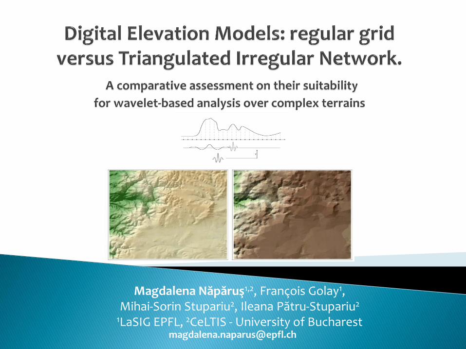
Magdalena Năpăruş1,2, François Golay1, Mihai-Sorin Stupariu2, Ileana Pătru-Stupariu2
1LaSIG EPFL, 2CeLTIS - University of Bucharest
ongoing Swiss-Romanian research project (2013-2015), aiming to connect wind, terrain and vegetation modeling
cross-disciplinary approach consisting in coupling 3 tracks:
1. Large Eddy Simulation techniques
2. 3D digital terrain representations
3. Landscape models and vegetation patterns
1. Evaluating the response of the multi-resolution digital
elevation models within wavelets analysis
2. Triangulated Irregular Network vs. regular grid:
pros and cons for 3D analyses
3. Assessing and mapping of wind potential over
complex terrains
Wavelets: Mallat (1989) was defining and developping the current wavelet
transform; Datcu et al. (1996) used wavelets to estimate the fractal dimension of DEM; Beyer (2003) and Lashermes et al. (2007) extracted geomorphometric indicators (terrain inclination, curvature) from wavelet coefficients
DEM grid wavelets: Kalbermatten et al. (2010) realized a multi-scale analysis
of topographic features by using the wavelet transform
WTIN: Wu & Amaratunga (2003) introduced a new multi-resolution data
representation: the Wavelet Triangulated Irregular Network (WTIN). The model is based on second generation of wavelet theory (lifting schemes) and it is specially designed for geographical height field data
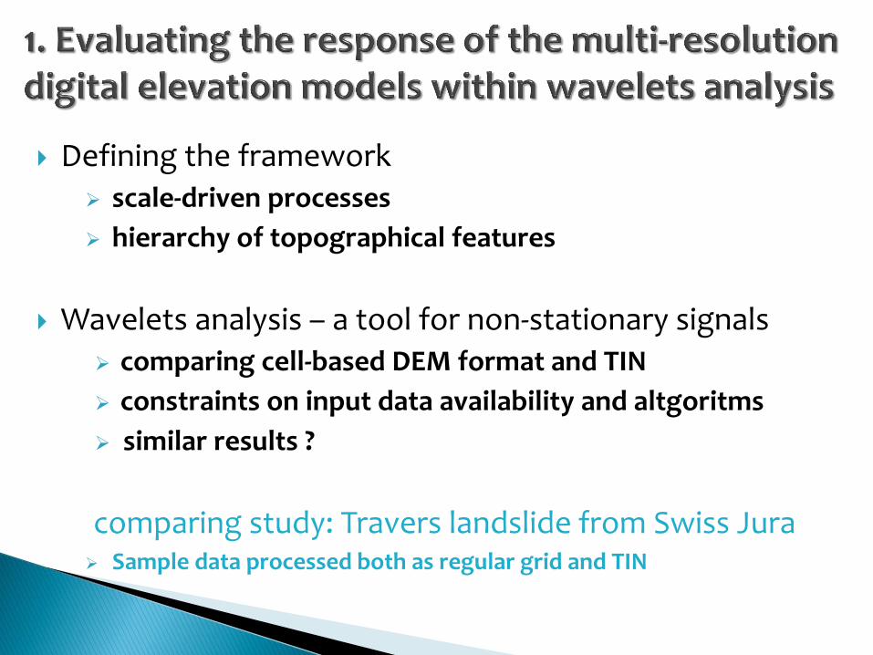
Defining the framework scale-driven processes
hierarchy of topographical features
Wavelets analysis – a tool for non-stationary signals comparing cell-based DEM format and TIN
constraints on input data availability and altgoritms
similar results ?
comparing study: Travers landslide from Swiss Jura Sample data processed both as regular grid and TIN
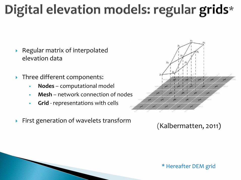
Regular matrix of interpolated
elevation data
Three different components:
Nodes – computational model
Mesh – network connection of nodes
Grid - representations with cells
First generation of wavelets transform
(Kalbermatten, 2011)
* Hereafter DEM grid
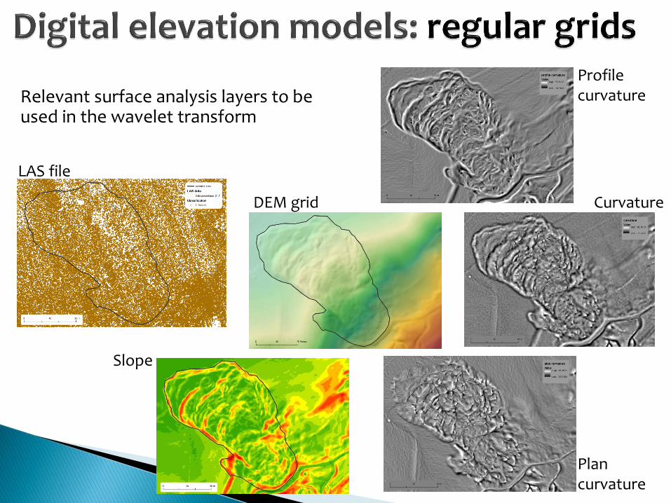
Relevant surface analysis layers to be used in the wavelet transform
LAS file
Plan curvature
Curvature DEM grid
Profile curvature
Slope
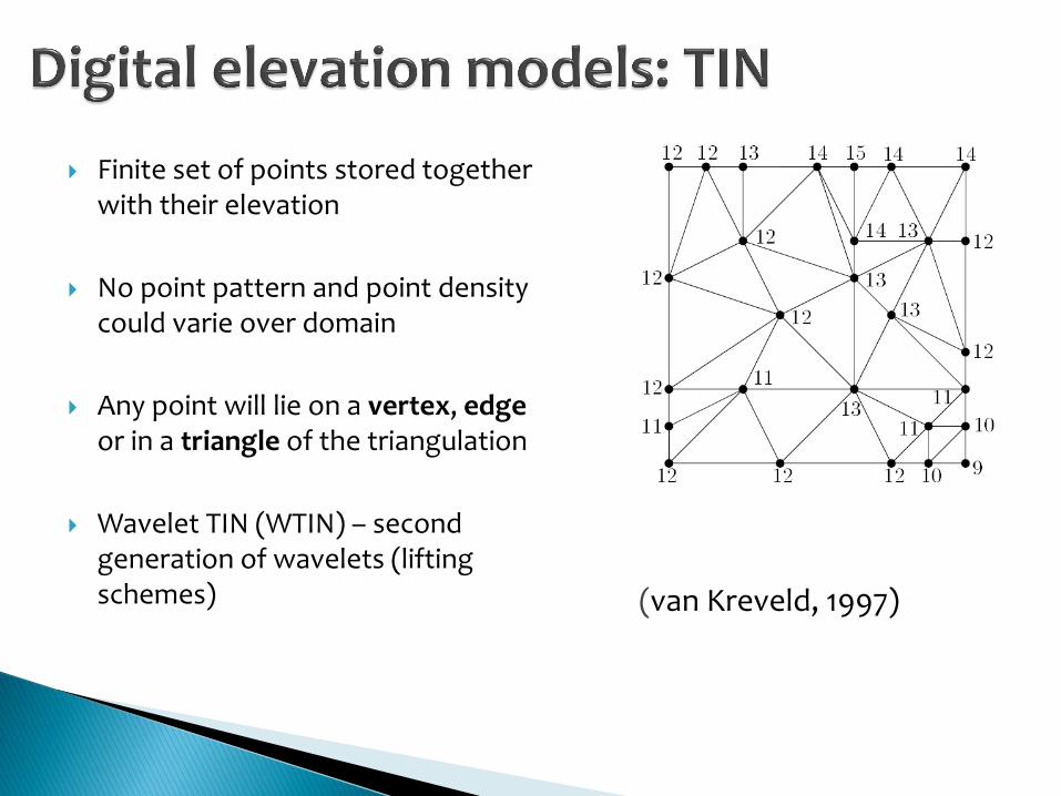
Finite set of points stored together with their elevation
No point pattern and point density could varie over domain
Any point will lie on a vertex, edge or in a triangle of the triangulation
Wavelet TIN (WTIN) – second generation of wavelets (lifting schemes)
(van Kreveld, 1997)
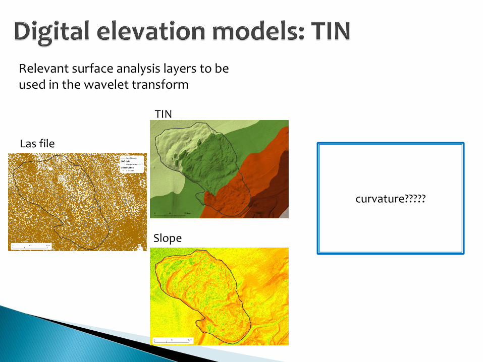
Relevant surface analysis layers to be used in the wavelet transform
Las file
Slope
TIN
curvature?????
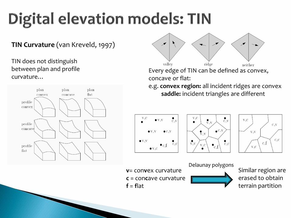
TIN Curvature (van Kreveld, 1997)
TIN does not distinguish between plan and profile curvature…
v= convex curvature c = concave curvature f = flat
Every edge of TIN can be defined as convex, concave or flat: e.g. convex region: all incident ridges are convex saddle: incident triangles are different
Similar region are erased to obtain terrain partition
Delaunay polygons
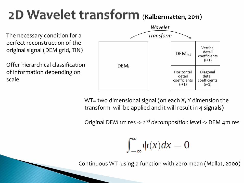
The necessary condition for a perfect reconstruction of the original signal (DEM grid, TIN) Offer hierarchical classification of information depending on scale
Continuous WT- using a function with zero mean (Mallat, 2000)
WT= two dimensional signal (on each X, Y dimension the transform will be applied and it will result in 4 signals) Original DEM 1m res -> 2nd decomposition level -> DEM 4m res
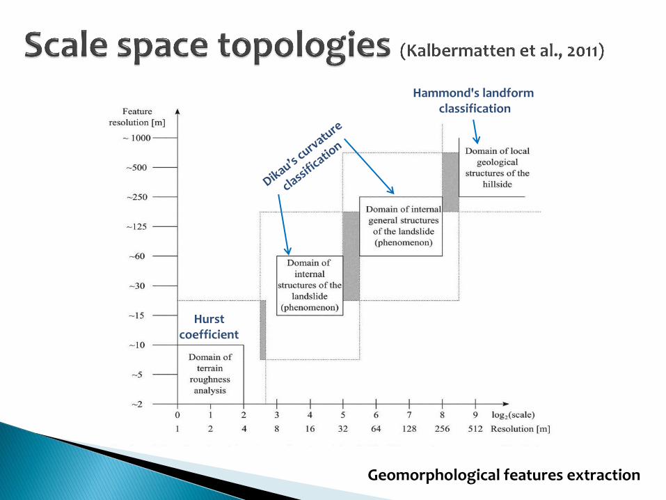
Hurst coefficient
Hammond's landform classification
Geomorphological features extraction

DEM grid TIN
Suitable for direct use in scalable distributed GIS
May loose terrain accuracy and may change the related terrain attributes
(slope , curbature, aspect...) (Deng et al., 2006)
not suitable for direct use in scalable distributed GIS services because it does not have a natural multi-resolution structure
need althgoritms to efficient edge collapse/vertex split
(Yang et al, 2005)
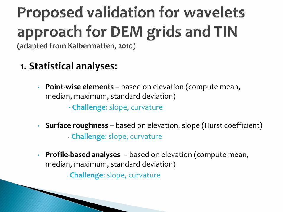
1. Statistical analyses:
• Point-wise elements – based on elevation (compute mean, median, maximum, standard deviation)
- Challenge: slope, curvature
• Surface roughness – based on elevation, slope (Hurst coefficient)
- Challenge: slope, curvature
• Profile-based analyses – based on elevation (compute mean, median, maximum, standard deviation)
- Challenge: slope, curvature
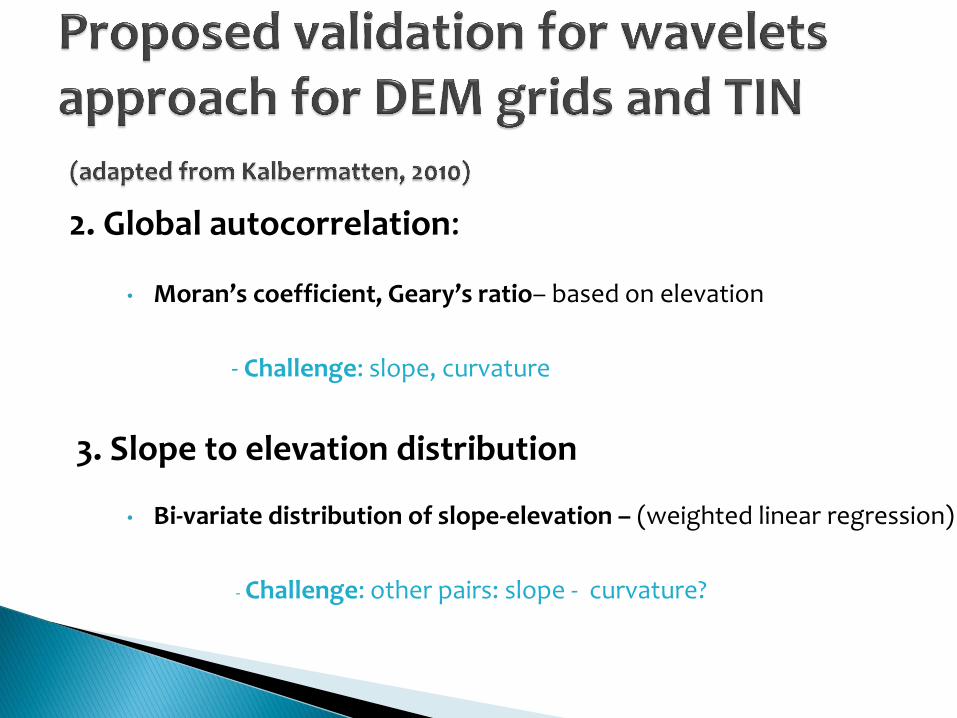
2. Global autocorrelation:
• Moran’s coefficient, Geary’s ratio– based on elevation
- Challenge: slope, curvature
3. Slope to elevation distribution
• Bi-variate distribution of slope-elevation – (weighted linear regression)
- Challenge: other pairs: slope - curvature?
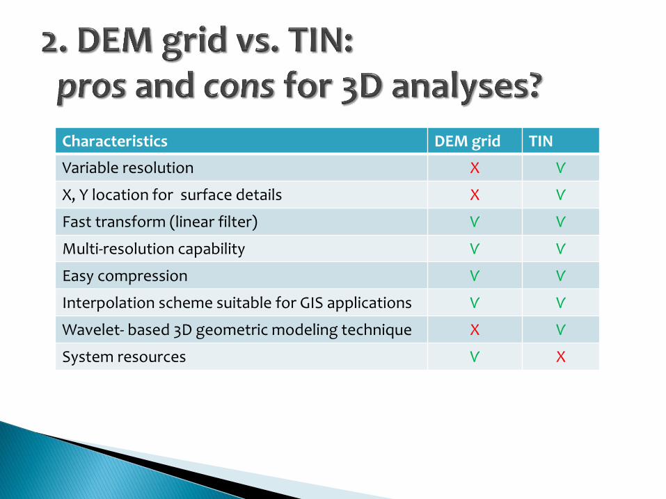
Characteristics DEM grid TIN
Variable resolution X Ѵ
X, Y location for surface details X Ѵ
Fast transform (linear filter) Ѵ Ѵ
Multi-resolution capability Ѵ Ѵ
Easy compression Ѵ Ѵ
Interpolation scheme suitable for GIS applications Ѵ Ѵ
Wavelet- based 3D geometric modeling technique X Ѵ
System resources Ѵ X
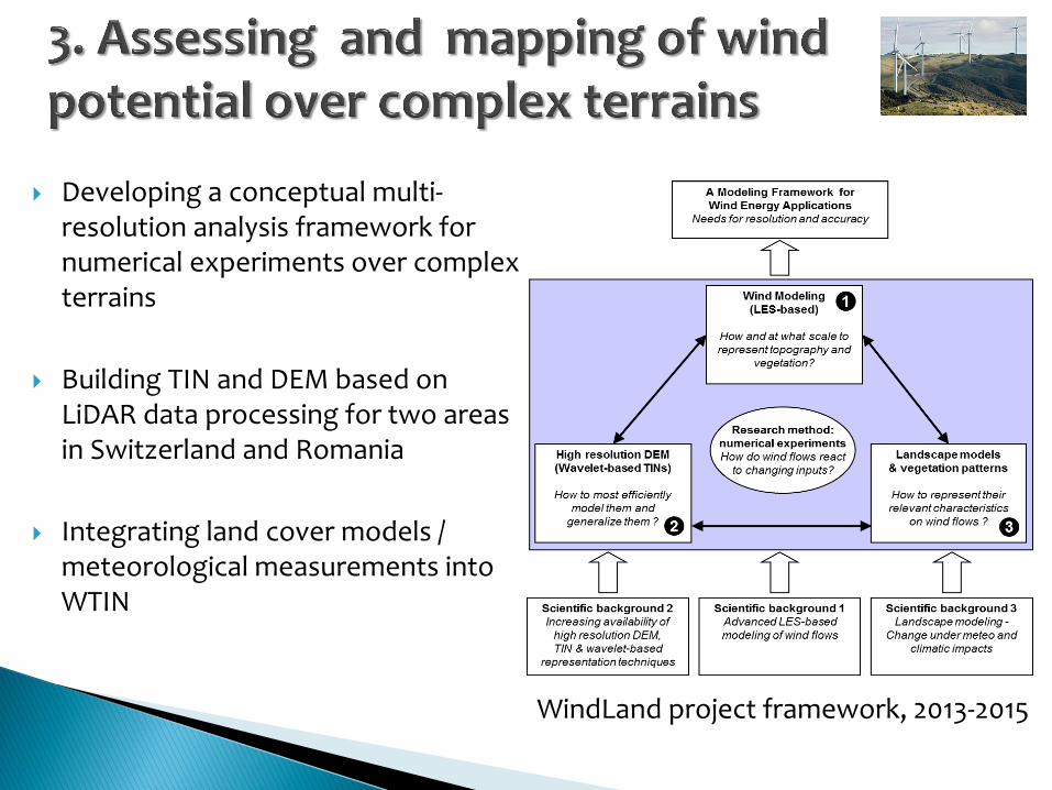
Developing a conceptual multi-resolution analysis framework for numerical experiments over complex terrains
Building TIN and DEM based on LiDAR data processing for two areas in Switzerland and Romania
Integrating land cover models / meteorological measurements into WTIN
WindLand project framework, 2013-2015
To create an unique modeling framework for DEM grid and TIN based on the previous research works
To identify all constraints and differences between the two terrain models
To integrate other types of data (land cover and meteorological measurements) in order to assess and map wind modeling over complex terrains (WindLand project)

Beyer, G. 2003. Terrain inclination and curvature from wavelet coefficients. Approximation formulae for the relief, Journal of Geodesy, 76:557-568.
Datcu, M., Luca, D., Seidel, K. 1996. Wavelet-based digital elevation model analysis, Proceedings of the 16th EARSeL Symposium: Integrated Applications for Risk Assessment and Disaster Prevention for the Mediterranean, Malta, pp. 283–290.
Deng, Y., Wilson, J. and Bauer, B. 2007. DEM resolution dependencies of terrain attributes across a landscape. International Journal of Geographical Information Science, 21(2): 187–213.
Dikau R. 1989.The application of a digital relief model to landform analysis in geomorphology. In: Raper, J. (Ed.): Three dimensional application in Geographic Information Systems, Taylor & Francis, p.51-77.
Kalbermatten, M., Van De Ville, D., Turberg, P., Tuia, D., and Joost, S., 2011. Multiscale analysis of geomorphological and geological features in high resolution digital elevation models using the wavelet transform. Geomorphology, 138(1):352-363.
Lashermes, B., Foufoula-Georgiou, E., Dietrich, W.E. 2007. Channel network extraction from high resolution topography using wavelets, Geophysical Research Letters 34.
Mallat, S. 1989. A theory for multiresolutional signal decomposition:The wavelet representation, IEEE Trans. Pattern Analysis And Machine Intelligence, vol. 31, No.7, pp. 674-693.
Stupariu, M.S., Patru-Stupariu, I., Cuculici R. 2010. Geometric approaches to computing 3D landscape metrics. Landscape Online 24:1-12.
Unser, M., Blu, T., 1999. Construction of fractional spline wavelet bases. Proceedings of the Proceedings of the SPIE Conference on Mathematical Imaging: Wavelet Applications in Signal and Image Processing, VII, pp. 551–560.
van Kreveld, M. 1997. Digital elevation models and TIN algorithms, Algorithmic Foundations of Geographic Information Systems, 37-78,Springer Berlin Heidelberg.
Wu, J., and Amaratunga, K., 2003. Wavelet triangulated irregular networks. International Journal of Geographical Information Science, 17:273-289.
Yang, B., Shi, W. and Li, Q. 2005. An integrated TIN and Grid method for constructing multi-resolution digital terrain models. International Journal of geographical Information Science, 19(10): 1019-1038.
Project collaborators and partners: FERNANDO PORTÉ-AGEL (WIRE) ALEXANDRE BUTTLER (ECOS) ALEXANDER PERINGER (ECOS)