040 florin-gheorghe fodorean 909-917rezumat. Într-un articol publicat în anul 20151 am prezentat...
TRANSCRIPT

ASOCIAŢIA ARHEO VEST TIMIŞOARA
ARHEOVEST
V2
-IN HONOREM DOINA BENEA-
Interdisciplinaritate în Arheologie și Istorie
Timişoara, 25 noiembrie 2017
JATEPress Kiadó
Szeged 2017
Editor: Sorin FORȚIU (cu mulțumiri pentru ajutorul punctual acordat lui Andrei STAVILĂ, Cristian OPREAN, Adrian CÎNTAR și Simona REGEP) Coordonator: Dorel MICLE DVD-ROM: Adrian CÎNTAR WEB: Sorin FORȚIU și Claudiu TOMA Coperta: Alice DUMITRAȘCU Foto copertă: Tudor VREME-MOSER, http://ideatm.ro/wordpress/ Această lucrarea a apărut sub egida:
© ArheoVest, Timișoara, 2017 Președinte Lorena SMADU
www.arheovest.com
ISBN 978-963-315-358-1 (Összes/General) ISBN 978-963-315-360-4 (II. kötet/volumul)
Avertisment: Acest volum digital este o imagine cât se poate de fidelă a celui tipărit.
Responsabilitatea pentru conţinutul materialelor revine în totalitate autorilor.
DVD-ROMul conține contribuțiile în varianta color precum și imaginile la rezoluția maximă trimisă de autor.
909
MAPPING ARCHAEOLOGICAL SITES IN DACIA. ROMAN RURAL SETTLEMENTS EAST OF APULUM
Florin-Gheorghe Fodorean* * Babeş-Bolyai University, Cluj-Napoca, Faculty of History and Philosophy, Department of Ancient History and Archaeology; [email protected] Rezumat. Într-un articol publicat în anul 20151 am prezentat şi am cartografiat câteva situri arheologice, toate amplasate de-a lungul drumului roman de la Apulum la Brucla. Contribuţia de faţă reprezintă o continuare a studiului precedent, cu precizarea că zona analizată acum este cea de la est de oraşul antic Apulum. Mai exact, am fost interesat în acest studiu de arealul delimitat la vest de râul Mureş, în nord de râul Târnava, iar în sud de râul Secaş. În ce priveşte zona de est, m-am oprit la zona care separă judeţele Alba şi Sibiu, evident nu din motive admi-nistrative, cît mai degrabă datorită faptului că suntem în acest areal la limita dintre bazinul hid-rografic al Mureşului şi cel al Oltului. Am folosit acceeaşi metodă ca şi în studiul anterior pen-tru a descrie siturile arheologice, pe care le-am clasificat în câteva categorii: 1. situri cu desco-periri arheologice diverse (categoria 1), incluzând: a. urme de aşezări, fundaţii de ziduri, frag-mente ceramice, ţigle, cărămizi, alte materiale de construcţie, precum şi artefacte din fier şi bronz; b. descoperiri funerare (incluzând necropole, morminte izolate, dar şi monumente fune-rare din necropole care au aparţinut unor aşezări rurale); c. descoperirea de monumente epigra-fice şi sculpturale (statui şi reliefuri votive, altare); d. descoperiri monetare (tezaure or desco-periri izolate de monede); 2. a doua categorie grupează trei tipuri de descoperiri: a. urme de aşezare; b. descoperiri funerare; c. descoperiri monetare; 3. a treia categorie include zone unde sunt semnalate doar urme de aşezare sau încă cel mult o altă categorie de descoperiri. Am folo-sit pentru analiza de faţă un set de hărţi publicate la mijlocul secolului trecut. Am corelat, de asemenea, datele din repertoriile arheologice locale cu cele din alte documente, precum Lista Monumentelor Istorice. Am cartografiat urmele înregistrate pe teritoriul următoarelor localităţi: Berghin, Ciugud, Daia Română, Doştat, Ghirbom, Hăpria, Henig, Mănărade, Seuşa și Straja. Cuvinte-cheie: arheologia peisajului, aşezări rurale, drumuri romane, hărţi, repertorii locale.
1. The rural settlements east of Apulum. General data Within the territory of the Alba County, the official document issued by the
Ministry of Culture, entitled LMI (the List of the Historical Monuments) records 202 archaeological sites, of which 38 belong to the Roman period. In RAN (The National Archaeological Repertory) there are 384 archaeological sites recorded, of which 96 belong to the Roman period. In the following, I will present and describe, using all the sources (current archaeological synthesis, local gazetteers, the archaeological repertory
1 Fodorean, 2015, p. 167-174.
910
of Alba County, articles published in journals etc.), the sites located east of Apulum, trying to identify and analyze their accurate location. The villages where there are re-corded archaeological discoveries from the Roman period in this area are: Berghin, Ciugud, Daia Română, Doştat, Ghirbom, Hăpria, Henig, Mănărade, Straja and Seuşa. I used the same method to classify the discoveries as in other studies2: 1. sites with multiples archaeological discoveries, including traces of settlements, wall foundations, stones, funerary discoveries, discoveries of epigraphic or sculptural mon-uments, monetary discoveries; 2. sites where traces of settlements, funerary monuments and coins were found; 3. sites where only one category of discoveries or maximum two are recorded.
I used accurate maps, with the scale of 1:20000.
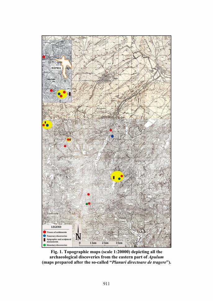
2. Archaeological discoveries in Berghin Berghin is a small village located circa 12 km east of Apulum. It is positioned
along the valley of a small rivulet, entitled Gârbău. Within the territory of this village, several discoveries are recorded, but, unfortunately, we do not have enough details to map all of them.3 The most important discovery seems to be the one mentioned in the eastern part of the village, unfortunately impossible to locate it, because of the inac-curate cartographic data. We only know that somewhere east of Berghin, between this village and those from its vicinity (Colibi and Secăşel) traces of a former rural settle-ment were recorded already since the middle of the 19th century. The archaeological repertory of Alba County records in this area the presence of wall foundations, of a large quantity of bricks and tiles, and several inscriptions. Also stamped tiles were discovered here and a silver ring. At no. 4, the same repertory records the discovery of ceramic fragments, but without any topographic data4. Another point recorded is the so-called “Lăscău”, somewhere in the north-western part of the village, where ceramic fragments were found.5 Unfortunately, the older maps published around the middle of the last century6, or the current topographic map, do not record such toponym. The next point recorded is also impossible to be located. It is mentioned a toponym entitled “Nimul de Jos”, somewhere 1 km north-east of the village, on the left bank of the rivulet Berghin, where ceramic pipes were observed. Unfortunately, on the topo-graphic maps such toponym does not exist7.
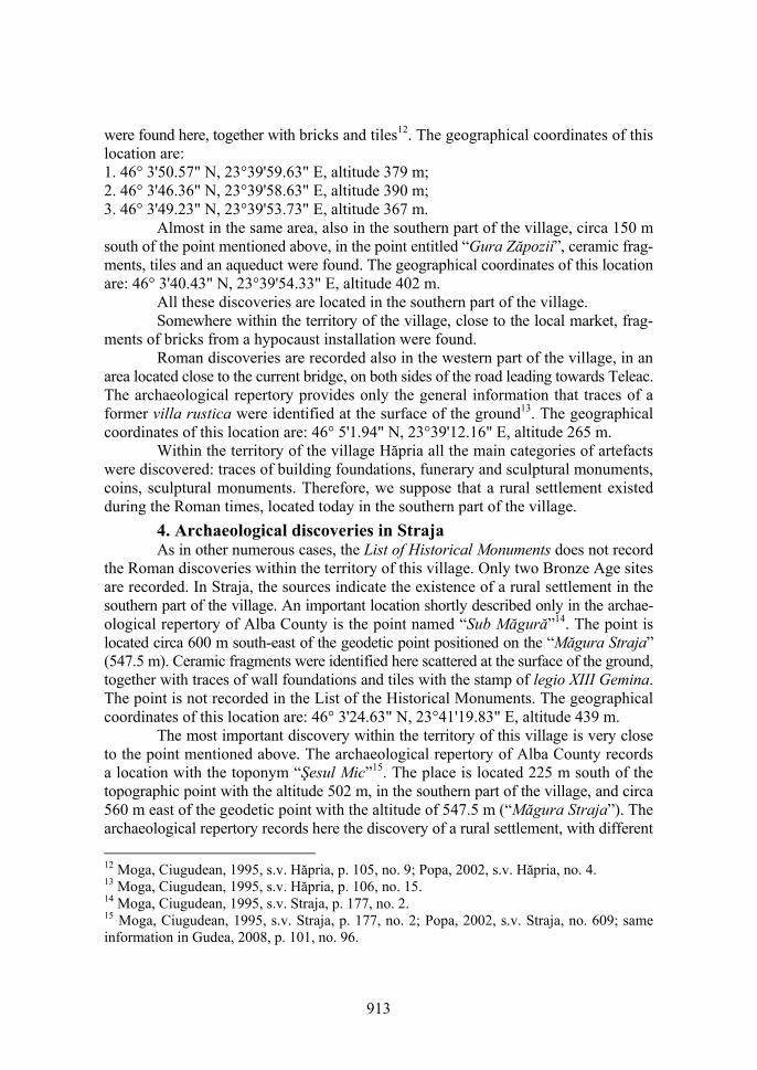
Only one point recorded in the archaeological repertory can be identified and it can be almost accurately mapped (Fig. 1). This is the so-called toponym “În Peri”. On the current topographic map such toponym is not mentioned. Instead, there is a hill entitled “Dealu Perilor”, which should be, obviously, the one mistakenly recorded in the repertory. This area is located circa 1350 m east of the southern entrance in the
2 Nemeti, Nemeti, Fodorean, 2003, p. 69-75; Fodorean, 2015, p. 167-174. 3 Moga, Ciugudean, 1995, s.v. Berghin, 55-56, no. 3, 4, 5, 6, 7, 8, 9. 4 Moga, Ciugudean, 1995, s.v. Berghin, 55, no. 4. 5 Moga, Ciugudean, 1995, s.v. Berghin, 55, no. 5. 6 The so-called “Planuri directoare de tragere” available on-line at http://www.geo-spatial. org/download/planurile-directoare-de-tragere . 7 Moga, Ciugudean, 1995, s.v. Berghin, 55, no. 6.
911
Fig. 1. Topographic maps (scale 1:20000) depicting all the
archaeological discoveries from the eastern part of Apulum (maps prepared after the so-called “Planuri directoare de tragere”).

912
village. A cemetery was discovered here, grouping Roman and early medieval graves (VIth–IXth century A.D.)8. This point is recorded in the List of the Historical Monuments of Alba County, with no. 27 and the code AB-I-s-B-00014 (no. 28, code AB-I-m-B-00014.01, the early medieval cemetery; no. 29, code AB-I-m-B-00014.02, the Roman cemetery)9. The geographical coordinates of this location are: 1. 46° 3'39.77" N, 23°44'56.97" E, altitude 428 m; 2. 46° 3'23.45" N, 23°45'14.01" E, altitude 372 m; 3. 46° 3'23.58" N, 23°44'40.27" E, altitude 431 m. I should mention that LMI records only the points mentioned above.
Beside these sites, a new point is mentioned in Ioana OLTEAN’s book10. The author published an oblique aerial photo which shows, in her opinion, traces of several rectangular houses belonging to a former Roman village. Oltean’s description do not offers other topographic or cartographic data. Based on the analysis of the photo, I succeeded to locate in Google Earth this place. The photograph in the book is rotated with the north in the bottom side and the south to the top. The crossroad on the photo is actually located in the southern entrance of the village, very close to the former sta-bles of the village. The geographical coordinates of this location are: 1. 46° 4'4.91" N, 23°44'2.92" E, altitude 300 m; 2. 46° 4'3.54" N, 23°44'7.51" E, altitude 294 m; 3. 46° 4'2.62" N, 23°44'5.78" E, altitude 295 m; 4. 46° 4'4.26" N, 23°44'2.70" E, altitude 300 m.
3. Roman sites within the territory of the village Hăpria The sites recorded within the territory of this village stand under a paradox, be-
cause LMI records only one small discovery: no. 99, code AB-I-s-B-00046 (cemetery, in the point entitled “Gruiul Cetăţii”). This point is not recorded in the archaeological repertory. On the other hand, the same repertory mentions ten locations where Roman artefacts were discovered and two small finds (two coins).11 The first important point with archaeological discoveries is located at “Vadul Bălgradului”. This point is located in the southern part of the forest “Pădurea Dumbrava”. The geographical coordinates of this location are: 1. 46° 3'55.08" N, 23°39'24.53" E, altitude 331 m. The site is po-sitioned along the valley of the rivulet Hăpria.
Another point is entitled “La Groape”, positioned in the southern part of the village, located circa 1800 south of the village church. The geographical coordinates of this location are: 1. 46° 3'49.66" N, 23°40'14.41" E, altitude 409 m. A sarcophagus was discovered here.
Another point is “Fântâna Lisului”, located also in the southern part of the vil-lage, exactly in the area where the spring of the rivulet is located. Ceramic fragments
8 Moga, Ciugudean, 1995, s.v. Berghin, 56, no. 9. 9 www.alba.djc.ro/DocumenteDownload.aspx?ID=4540 (accessed on 17.02.2016). 10 Oltean, 2007, p. 145 and 146, fig. 5.18 and fig. 5.19. 11 Moga, Ciugudean, 1995, s.v. Hăpria, p. 105, 106, no. 4, 5, 6, 7, 8, 9, 10, 11, 12, 14, 15, 16.
913
were found here, together with bricks and tiles12. The geographical coordinates of this location are: 1. 46° 3'50.57" N, 23°39'59.63" E, altitude 379 m; 2. 46° 3'46.36" N, 23°39'58.63" E, altitude 390 m; 3. 46° 3'49.23" N, 23°39'53.73" E, altitude 367 m.
Almost in the same area, also in the southern part of the village, circa 150 m south of the point mentioned above, in the point entitled “Gura Zăpozii”, ceramic frag-ments, tiles and an aqueduct were found. The geographical coordinates of this location are: 46° 3'40.43" N, 23°39'54.33" E, altitude 402 m.
All these discoveries are located in the southern part of the village. Somewhere within the territory of the village, close to the local market, frag-
ments of bricks from a hypocaust installation were found. Roman discoveries are recorded also in the western part of the village, in an
area located close to the current bridge, on both sides of the road leading towards Teleac. The archaeological repertory provides only the general information that traces of a former villa rustica were identified at the surface of the ground13. The geographical coordinates of this location are: 46° 5'1.94" N, 23°39'12.16" E, altitude 265 m.
Within the territory of the village Hăpria all the main categories of artefacts were discovered: traces of building foundations, funerary and sculptural monuments, coins, sculptural monuments. Therefore, we suppose that a rural settlement existed during the Roman times, located today in the southern part of the village.
4. Archaeological discoveries in Straja As in other numerous cases, the List of Historical Monuments does not record
the Roman discoveries within the territory of this village. Only two Bronze Age sites are recorded. In Straja, the sources indicate the existence of a rural settlement in the southern part of the village. An important location shortly described only in the archae-ological repertory of Alba County is the point named “Sub Măgură”14. The point is located circa 600 m south-east of the geodetic point positioned on the “Măgura Straja” (547.5 m). Ceramic fragments were identified here scattered at the surface of the ground, together with traces of wall foundations and tiles with the stamp of legio XIII Gemina. The point is not recorded in the List of the Historical Monuments. The geographical coordinates of this location are: 46° 3'24.63" N, 23°41'19.83" E, altitude 439 m.
The most important discovery within the territory of this village is very close to the point mentioned above. The archaeological repertory of Alba County records a location with the toponym “Şesul Mic”15. The place is located 225 m south of the topographic point with the altitude 502 m, in the southern part of the village, and circa 560 m east of the geodetic point with the altitude of 547.5 m (“Măgura Straja”). The archaeological repertory records here the discovery of a rural settlement, with different
12 Moga, Ciugudean, 1995, s.v. Hăpria, p. 105, no. 9; Popa, 2002, s.v. Hăpria, no. 4. 13 Moga, Ciugudean, 1995, s.v. Hăpria, p. 106, no. 15. 14 Moga, Ciugudean, 1995, s.v. Straja, p. 177, no. 2. 15 Moga, Ciugudean, 1995, s.v. Straja, p. 177, no. 2; Popa, 2002, s.v. Straja, no. 609; same information in Gudea, 2008, p. 101, no. 96.
914
elements, such as wall foundations, bricks, tiles and ceramic fragments. It seems that even Roman monuments were discovered in this point, also fragments of statues. Even traces of a former Roman road were identified here. The road is known as “Drumul Barbarilor” or “Calea Mureşului”. The geographical coordinates of this location are: 46° 3'42.12" N, 23°41'30.90" E, altitude 466 m.
As in the case of Hăpria, in the point “Şesul Mic”, south of Straja, all the main categories of artefacts were discovered: traces of building foundations, funerary and sculptural monuments, coins, sculptural monuments.
5. Traces from the Roman period in Ciugud, Şeuşa, Daia Română The List of Historical Monuments records only one site in Ciugud. This is the
so-called “Gorneţ”, a place situated circa 690 m north-east of the center of the village16. The geographical coordinates of this location are: 46° 2'58.58" N, 23°36'13.09" E, altitude 216 m. LMI records this point with no. 51, code AB-I-m-B-00026.02. Only ceramic fragments were discovered here.
In Şeuşa, even if the archaeological repertory supposes the existence of a rural settlement, the discoveries rather indicate that it is too much to affirm this. Only two funerary monuments are recorded here.
The same scarcity is revealed for the discoveries within the territory of the vil-lage Daia Română.17 There is a point with Roman discoveries recorded also in LMI. This is no. 60, code AB-I-m-B-00032.01, with a toponym entitled “Troian”. Unfortu-nately, the point be located.
6. The rural settlement in Ghirbom By far, one of the most important rural settlements in this area developed during
the Roman times in the regions covering today the village of Ghirbom and its vicinity18. The List of Historical Monuments records no less than 27 positions with archaeolo-gical discoveries for Ghirbom (from no. 69 to no. 95). Of these, only two records are referring to discoveries from the Roman period: no. 83, code AB-I-m-B-00041.02, in a place entitled “Capul Şesului” – settlement; no. 91, code AB-I-m-B-00044.02, in a place entitled “Hamboc - Ciorcobară” – settlement. The archaeological discoveries within the territory of this village area spread in two areas: in the southern part of the village, and in the north-eastern part, in a point north of the area mapped with the topo-nym “Pădurea Sasului”.
The first point recorded in the archaeological repertory of Alba County is one recorded with the toponym “Între Veli”19. The point is also mentioned in other reper-tories20. Tabula Imperii Romani L 34 (TIR L34) records only some general data about the discoveries within the territory of this village21. In 1967 archaeological excavations 16 Moga, Ciugudean, 1995, s.v. Ciugud, p. 77, no. 1. 17 Moga, Ciugudean, 1995, s.v. Daia Română, p. 89, no. 2. 18 Moga, 1998, p. 161-168. 19 Moga, Ciugudean, 1995, s.v. Ghirbom, p. 98, no. 2. 20 Aldea, Moga, Ciugudean, 1979, p. 257-261; Popa, 2002, s.v. Ghirbom, no. 1; Gudea, 2008, p. 90, no. 47. 21 TIR L 34, s.v. Ghirbom, 61.

915
started in this point. The archaeological discoveries were recorded on both sides of the rivulet Hamboc. On the western part of this rivulet, Vasile MOGA excavated in 1975 a building of 10.60 × 8.40 m, with wall of opus incertum, with a thickness of 0.60 – 0.70 m. The author mentioned that parallel with the southern wall of the build-ing another brick wall was found. In this area, in fact, a heating system of hypocaustum was identified. A plan of the building was published by the author. One should be aware that the scale of the draw seems to be inaccurate, since in the text the author mentioned that the building is of 10.60 × 8.40 m22. The draw shows a building with al “L” shape heating system, located on the eastern and the southern side of the building. Only few small finds were discovered during the excavations. Some ceramic fragments were found, a fibula, and some fragments of glass.
The geographical coordinates of this location are: 46° 1'32.61" N, 23°42'51.04" E, altitude 352 m. I should outline that this discovery is not included in LMI. It should be listed, obviously.
Another point with Roman discoveries recorded in the archaeological repertory of Alba County in the so-called “Ciorcobară”23. This point is mentioned in LMI with no. 91, code AB-I-m-B-00044.02. The geographical coordinates of this location are: 46° 1'10.57" N, 23°42'45.86" E, altitude 373 m. This location is position circa 650 m south of the point “Între Veli”, also positioned in the southern part of the village. A building was also identified here, with remains from the stone foundations, and a coin.
Moving now in the north-eastern part of the village, we have to mention another important location, where Roman artefacts were found. This is the point entitled “Capul Şesului”. The point is recorded in LMI with no. 83, code AB-I-m-B-00041.02. The geographical coordinates of this location are: 1. 46° 2'44.75" N, 23°44'59.68" E, altitude 360 m; 2. 46° 2'47.43" N, 23°44'59.81" E, altitude 355 m; 3. 46° 2'46.08" N, 23°44'52.79" E, altitude 357 m; 4. 46° 2'42.44" N, 23°44'53.26" E, 366 m. Another building was discovered here. It was partially excavated. The wall foundations were found, together with ceramic fragments, several stamped bricks, tiles and a sil-ver coins24.
Close to this point, circa 300 m west of it, in a location known as “Faţa Crasnei” (unmapped on the current topographic plans), a Roman funerary monument and two cremation graves were found25.
7. Roman sites within the territory of the villages Doştat, Mănărade Traces of Roman constructions, ceramic and other small finds in Doştat were
identified in a point which, unfortunately, can not be located. This is entitled “Zidul”26. Within the territory of the village Mănărade traces of a Roman road are recorded,
22 Moga, 1998, p. 166, pl. II. 23 Aldea, Moga, Ciugudean, 1979, p. 261; Moga, Ciugudean, 1995, s.v. Ghirbom, p. 99, no. 6. 24 Moga, Ciugudean, 1995, s.v. Ghirbom, p. 99, no. 7. 25 Moga, Ciugudean, 1995, s.v. Ghirbom, p. 99, no. 8. 26 Moga, Ciugudean, 1995, s.v. Doştat, p. 91, no. 2.
916
together with the discovery of several other Roman artifacts. Unfortunately, I could not establish the accurate location of the Roman road27.
8. Villages without archaeological discoveries There are no archaeological discoveries from the Roman period recorded within
the territory of the villages Boz, Carpen, Cenade, Cergău Mic, Cergău Mare, Colibi, Cunţa, Cut, Dealul Doştatului, Deleni-Obârşie, Draşov, Drâmbar, Doştat, Fliteşti, Gorgan, Limba, Lupu, Măghierat, Mănărade, Oarda, Ohaba, Roşia de Secaş, Secăşel, Spătac, Şpring, Tău, Teleac, Totoi, Ungurei and Vingard.
9. Conclusions. Types of rural settlements east of Apulum The area on which we focused our attention is known, partially, from previous
researches, such as archaeological excavations or archaeological field surveys. After the analysis and the mapping of the discoveries, we observed an interesting situation. The most important and consistent discoveries are recorded within the territory of the village Ghirbom. The village is situated circa 12 kilometers in straight line east of Apulum. Two areas with Roman discoveries can be delimited here. Altogether, based on these archaeological finds, we can include this settlement in the first category, those where all the major discoveries are recorded (foundations of walls, ceramic fragments, tiles, bricks, other construction materials, stone fragments, funerary discoveries, funerary monuments, epigraphic or sculptural monuments, and monetary discoveries). It the second category we should include the discoveries within the territory of the village Hăpria. Traces from the former Roman settlement were identified here in the southern part of the village. The other two villages where Roman archaeological finds were re-corded are Straja and Berghin. Within the territory of these villages, only two categories of discoveries were recorded. What should be noticed is related to the importance of the Roman road. Along the main imperial Roman road north of Apulum several impor-tant rural settlements are attested. These are located in Șard, Ighiu, Bucerdea Vinoasă and Cricău. The road was, obviously, a key factor in the development of these settle-ments, in Dacia or in other regions of the Roman Empire.
27 Moga, Ciugudean, 1995, s.v. Mănărade, p. 123, no. 1.

917
BIBLIOGRAPHY
Aldea, Moga, Ciugudean, 1979
Ioan Al. ALDEA, Vasile MOGA, Horia CIUGUDEAN, Săpăturile arheo-logice de la Ghirbom (campania 1978). Raport preliminar, In: Materiale şi cercetări arheologice, 13, 1979, pp. 257-261.
Fodorean, 2015
Florin FODOREAN, Landscape archaeology in Dacia: Mapping the Roman discoveries along the road Apulum – Brucla, In: Sorin COCIȘ, Monica GUI, Vlad-Andrei LĂZĂRESCU, Dan-Augustin DEAC (eds), Ad finem Imperii Romani. Studies in Honour of Coriolan H. Opreanu, Ed. Mega, Cluj-Napoca, 2015, 390 pg., ISBN 978-606-543-600-8; pp. 167-174.
Gudea, 2008 Nicolae GUDEA, Aşezări rurale în Dacia romană (106 – 275 p.Chr.). Schiţă pentru o istorie a agriculturii şi satului daco-roman, Univer-sitatea "Babeş-Bolyai" din Cluj-Napoca, Facultatea de Teologie Greco- Catolică, Ed. Primus, Oradea, 2008, 268 pg., ISBN 9738885248.
Moga, 1998 Vasile MOGA, Recherches sur l’epoque romaine à Ghirbom, In: Victor Henrich BAUMANN (ed), La politique édilitaire dans les provinces de l’Empire romain II ème-IVème siècles après J.-C, Actes du IIIème Colloque Roumano-Suisse "La vie rurale dans les provinces romaines: vici et villae" (Tulcea, 8–15 Octobre 1995), Ed. Brastar Print, Tulcea, 1998, 284 pg., ISBN 973-98041-3-6; pp. 161-168.
Moga, Ciugudean, 1995
Vasile MOGA, Horia CIUGUDEAN (redactori) [et alii], Repertoriul arheologic al judeţului Alba, Muzeul Naţional al Unirii Alba Iulia, Bib-liotheca Mvsei Apvlensis, II, Alba Iulia, 1995, 271 pg., 33 Pl. + o hartă.
Nemeti, Nemeti, Fodorean, 2003
Sorin NEMETI, Irina NEMETI, Florin FODOREAN, Territorium Pota-issae, In: Revista Bistriței, 17, 2003, pp. 69-75.
Oltean, 2007 Ioana A[dina]. OLTEAN, Dacia. Landscape, colonisation and ro-manisation, Routladge, Taylor & Francisc Group, London and New York, 2007, xii + 248 + [2] pg., ISBN 0-203-94583-2, ISBN 0-415-412 52-8, 978-0-415-41252-0.
Popa, 2002 Dumitru POPA, Villae, vici, pagi. Așezările rurale din Dacia romană intracarpatică, Bibliotheca Septemcastrensia, 2, Ed. Economică, Bucu-rești, 2002, 256 pg., ISBN 973-590-706-2.
TIR L 34 SOPRONI Sándor (ed), Aquincum-Sarmizegetusa-Sirmium : auf dem Grunde der Weltkarte 1:1000000, L 34 Budapest, Magyar Tudományos Akadémia, 1968, 123 pg., 1 plate.