0e0llenlo - geografie-craiova.rogeografie-craiova.ro/wp-content/uploads/geoltenia_nr_1.pdf ·...
TRANSCRIPT

0e0llenloREyrsTA STUDINTI0R GA0Grur D[ rA
IINNMRSITATEA DN CRAIOVA
ANULI, NR. ICRAIOVA
200s
REVISTA STUDEN ILOR GEOGRAFI DE LAUNIVERSITATEA DIN CRAIOVA
Num r special dedicat centenarului na terii Prof. univ. dr. doc. N. Al. R dulescu.
ANUL I, NR. 1
EDITURA UNIVERSITARIA 2005
COORDONATOR
Conf. univ. dr. Costela Iordache
CONSILIUL TIIN IFIC
Conf. univ. dr. Viorica TomescuConf. univ. dr. Vasile PleniceanuConf. univ. dr. Costela IordacheAsist. univ. drd. Alina Vl du
MEMBRII FONDATORI
Sorin Avram Ionu B loiAndreea Caracud Corina Maria CheluElisabeta Ciocan Nicu or DimieruRadu Idi oiu Delia IonescuOana Ionu Lauren iu NicaMihaela Licurici Andreea Ristea Georgiana Tranc
COLEGIUL DE REDAC IE
Redactor- ef: Mihaela Licurici Redactor- ef adj.: Sorin Avram
Secretar general de redac ie: Andreea Caracud , Andreea Ristea
Lucr rile au fost sus inute la Sesiunea anual de comunic ri tiin ifice a studen ilor,Craiova – 2005
ISSN 1584-9023

1
CUPRINS CONTENTS
Licurici Mihaela, Avram Sorin – Prof. univ. dr. doc. N. Al. R dulescu / Professor sc. d. N. Al. R dulescu (1905 - 1989) …………………………………………………….... 2
Ionescu Delia – Reparti ia geografic a celor mai ridicate temperaturi maxime zilnice înregistrate în Oltenia în vara anului 2002 / Geographic distribution of the highestmaximum air-temperatures in Oltenia in the summer of 2002 ....................................
5
Dimieru Nicu or – Tendin e de evolu ie a temperaturii medii anuale în România / Les tendances d’évolution de la temperature moyenne annuelle en Roumanie ………...... 11
Ionu Oana – Vara 2003 în Oltenia i impactul s u direct asupra activit ilor socio-economice /L’été 2003 en Oltenie et son impact direct sur les activités socio-économiques...................................................................................................................
18
Tranc Georgiana – Reconstruc ia ecologic forestier pe terenurile nisipoase în perimetrul ora ului D buleni / Ecologic forestry reconstruction on the sandy soils in the D buleni village perimeter…………………………………………......................
26
Avram Sorin – Dezvoltarea istorico- urbanistic a ora ului Monza – Italia / The historical and urban development of the city of Monza –Italy……………………………………………………………………………………
33
Ciocan Elisabeta – Modul de utilizare a terenurilor în localitatea F rca . Modific ri antropice recente / La manière d’utiliser les terrains dans la commune Farca . Les modifications anthropiques récentes …………………………………………………
39
Licurici Mihaela – Municipiul Craiova: transportul rutier de c l tori în contextul dezvolt rii durabile / Craiova: passenger mass transit within the soustainable development framework ………………………………………………………………
49
Vl du Alina – Programul Socrates/Erasmus / Socrates/Erasmus exchange programme.... 56 Popescu Liliana – Sesiunea anual de referate i comunic ri tiin ifice studen e ti, edi ia
a XII-a, Craiova / The annual meeting for students’ scientific papers, 10th edition, Craiova ………………………………………………………………………………..
57
Vl du Alina – Tab ra de ecologizare Bu teni / Bu teni ecologization camp ..................... 59 Andreea Caracud , Andreea Ristea, Lauren iu Nica – Practica de teren a studen ilor
din anul I / The first year students’ field training…………………………………...... 61
B loi Ionu , Chelu Corina Maria, Idi oiu Radu – Aplica ia practic a anului II în Delta Dun rii / The second year students’ field training within the Danube Delta ………... 66

2
PROF. UNIV. DR. DOC. N. AL. R DULESCU
PROFESSOR SC. D. N. AL. R DULESCU (1905 - 1989)
Personalitate marcant a colii geografice române ti, prof. univ. dr. doc. N. Al. R dulescu s-a n scut în anul 1905, în localitatea Bude ti, din jude ul Vrancea. Urmeaz cursurile colii din satul natal, apoi liceul “Unirea” din Foc ani, pe care îl absolv în anul 1924. Se înscrie la Universitatea Bucure ti, Facultatea de Litere i Filosofie, sec iaGeografie, finalizându- i studiile universitare în 1927, cu lucrarea de licen intitulat “Valea Râmnei”. În anul 1929 a absolvit Seminarul Pedagogic Universitar din Bucure ti.
Pentru scurt timp func ioneaz ca profesor la Odobe ti i ca asistent la Institutul de Geografie al Universit ii din Cern u i. Revine în Vrancea, la Foc ani, ca profesor titular “în înv mântul secundar al b ie ilor”.
Între anii 1934 - 1939 a predat la Liceul de Aplica ie al Seminarului Pedagogic Universitar din Cluj; spre sfâr itul perioadei (octombrie 1938) sus ine cursurile de Antropogeografie si Geopolitic de la Universitatea Bucure ti.
Ocup posturile de conferen iar, apoi de profesor la Academia de Înalte Studii Industriale iComerciale din Bucure ti, în cadrul c reia deschide o nou perspectiv de dezvoltare a geografiei economice.
În perioada 1947 – 1952, a fost profesor la Facultatea de Geografie din Bucure ti. Despre profesorul s u din acei ani, D. Bug nota (1999, p. 211): “prezen a dânsului…ca i a altor cadre didactice din genera ia sa, datorit preg tirii profesionale, competen ei, inutei academice i, de ce nu, harului didactic, a reu it s asigure continuarea tradi iei înv mântului geografic universitar i s deschid , în acela i timp, c i noi în dezvoltarea acestei discipline care î i câ tigase un prestigiu în lumea tiin ific româneasc iinterna ional .”
Din considerente politice este înl turat din înv mântul superior, în care revine dup zece ani de umilin e i nedrept i. La începutul anului universitar 1963 – 1964 î i reia activitatea universitar în cadrul Universit ii din Craiova. Încalitate de ef de catedr i decan (1964 - 1966) al Facult ii de Istorie – Geografie, dar i de prorector(1965 - 1974) al Universit ii, a avut o contribu ieremarcabil la organizarea i coordonarea vie ii academice craiovene.
Noteworthy personality of the RomanianGeographic School, Professor Sc. D. N. Al. R dulescu was born in 1905, at Bude ti, a settlement located within the Vrancea department. He attended the elementary school in his native village, then the “Unirea” highschool at Foc ani, leaving school in 1924. He applied for the University of Bucharest, the Faculty of Letters and Philosophy, the Geography Section and he graduated in 1927, with the sustenance of his master’s degree thesis named “Valea Râmnei” (“The Râmna Valley”).The year 1929 marks N. Al. R dulescu’s graduation from the Pedagogic Academic Seminary of Bucharest.
For a short while, he worked as a teacher at Odobe ti and as a teaching assistant at the Geographic Institute of the University of Cern u i.Later on, he returned to Vrancea, at Foc ani, to be a titular professor within “the secondary education for boys”.
Between 1934 and 1939, he was a teacher at the Application Highschool of the Pedagogic Academic Seminary of Cluj; towards the end of this period (October 1938) he sustains the lectures on Anthropogeography and Geopolitics at the University of Bucharest.
N. Al. R dulescu obtains the title of lecturer, and later on of professor, at the Academy of High Industrial and Commercial Studies of Bucharest, his work opening a new perspective in the development of the economic geography.
Between 1947 and 1952, he was a professor at the Faculty of Geography in Bucharest. D Bugwrote about his mentor (1999, p. 211): “his presence… as well as that of other professors belonging to the same generation, owing to their professional preparedness, competence, academic conduct and, why not, the didactic gift, succeeded in preserving the tradition of the academic geographic education and in opening new paths for the development of this discipline that had already gained prestige in the Romanian and international scientific world”.
Political reasons determined N.Al.Radulescu’s dismission from the superior education, his return being possible only after ten years of injustice and humiliations. At the beginning of the academic year 1963-1964, N.Al.Radulescu returns to his university activity at the University of Craiova.
As a chief of department (1964 - 1966) at the

3
În prodigioasa sa carier didactic universiatra sus inut numeroase cursuri, printre care men ion m: “Istoria geografiei i adescoperirior geografice”, “Geopolitica”, “Antropogeografie”, “Geografie economica general ”, “Geografie economic a României”, “Hidrologie”, “Regionare fizico-geografic ”, “Geografia turismului” etc.
A avut o activitate publicistic vast i de pionierat. În acest sens, amintim revista “Milcovia” (1930 - 1937), ap rut la Foc ani, sub redac ia lui N.Al. R dulescu, în care sunt prezente studii regionale atât din domeniul geografiei fizice, cât ia celei economice. În perioada clujean , a fondat “Revista Geografic Român ”, care a ap rut în 12 fascicule, între anii 1938 – 1943. Pe lâng articole cu con inut fizico i economico-geografic, se reg sesc i studii etnografice, lingvistice, note, recenzii .a.
În 1937 a v zut lumina tiparului teza sa de doctorat “Vrancea – Geografie fizic i uman ”distins , un an mai târziu, cu premiul Academiei Române.
În marea i valoroasa list a studiilor ilucr rilor publicate de prof. univ. dr. doc. N. Al. R dulescu se înscriu:
“Clima Moldovei de Sud” (1930); “Introducere sumar în geografia economic ”
(1941); “Unitatea i func iunile p mântului i
poporului românesc” (1943 – coautor); “Geografia economic a României” (1944); “Zonele de aprovizionare apropiat a câtorva
ora e din sudul României” (1946); “Asupra geografiei turismului” (1947 – primul
articol de acest gen din România); “Introducere în Antropogeografie” (1947); “Harta reparti iei geografice a categoriilor de
folosin a terenurilor, a culturilor agricole icre terea animalelor pe întreaga ar (sc. 1:200.000)” (1949-1951, coautor);
“R spândirea alunec rilor de teren în R.P.R.” (1959);
“Deficitul de umiditate în sol la principalele culturi agricole din R.P.R.” (1960, coautor);
“Considera iuni geografice asupra fenomenelor de secet din R.P.România” (1964);
“Contribu ii geografice la lucr rile de ameliora ii agricole i de sistematizare a teritoriului R.P.R.” (1964);
“Schi a fenologic a R.S.România, în func iede începutul seceratului grâului de toamn ” (1967);
“Aspecte geografice în ac iunea de protec ie iconservare a terenurilor agricole din R.S.România” (1968);
“Geografia agriculturii României” (1968); “Folosirea datelor fizico-geografice in
cercet rile economico-geografice” (1969); “Caracterul aplicativ al geografiei ca tiin i
obiect de înv mânt” (1971);
Faculty of History – Geography and as a Vice-President (1965 – 1974) of the University, he had aremarkable contribution to the organisation and the co-ordination of Craiova’s academic life.
During his remarkable didactic career at the university, N.Al.Radulescu sustained an important number of lectures, among the most important ones being: “History of Geography and of Geographic Discoveries”, “Geopolitics”, “Anthropogeography”, “General Economic Geography”, “Economic Geography of Romania”, “Hydrology”, “Physical-geographic Regionalisation”, “Geography of Tourism” etc.
N.Al.Radulescu had an extensive and innovative publicistic activity. Thus, we mention the “Milcova” magazine that appeared at Foc ani, having professor R dulescu as editor; the publication presents regional studies both from the physic and economic domains of geography. At Cluj, he set up the “Romanian Geographic Magazine”, which appeared in 12 fascicles, between 1938 and 1943; along with the articles on physic and economic geography, there also appeared various ethnographic or linguistic studies, notes, reviews etc.
In 1937, it was published N.Al. R dulescu’s doctoral dissertation, named “Vrancea – physic and human geography”; a year later, this paper received the Romanian Academy award.
In the long list of important studies and papers published by professor R dulescu there are comprised:
“Southern Moldavia’s climate” (1930); “Brief introduction in the economic geography
domain” (1941); “Unity and functions of the Romanian territory
and nation” (1943, joint author); “Economic geography of Romania” (1944); “The near provisioning areas of some cities
located in Southern Romania” (1946); “On the geography of tourism” (1947 – the first
article of the sort ever published in Romania); “Introduction in Anthropogeography” (1947); “Geographic repartition map of the use
categories of agricultural fields and cultures and of animal breading at the national level” (1:200.000) (1949 – 1951, joint author);
“Spread of landslides on the territory of the Popular Republic of Romania” (1959);
“Humidity deficit of the soil in relation to the main cultures in the Popular Republic of Romania” (1960, joint author);
“Geographic appreciations concerning the draught phenomena in the Popular Republic of Romania” (1964);
“Geographic contributions to the land improvement works and systematisation of the Popular Republic of Romania’s territory” (1964);
“Romanian phenologic plan depending on the beginning of winter wheat harvest” (1967);

4
Pe lâng implicarea sa în dezvoltarea geografiei române ti i în crearea scolii geografice craiovene, prof. univ. dr. doc. N. Al. R dulescu a avut o contribu ie important la formarea iafirmarea unor mari geografi de ast zi.
În semn de pre uire, dedic m acest prim num ral revistei noastre memoriei prof. univ. dr. doc. N. Al. R dulescu.
“Geographic aspects in the process of protection and conservation of the Socialist Republic of Romania’s agricultural fields” (1968);
“Geography of Romania’s Agriculture” (1968); “The use of physic-geographic data in the
economic-geographic research” (1969); “The applicative character of geography as a
science and as object of study” (1971); Besides his involvement in the development of the
Romanian geography and in the creation of Craiova’s Geography School, professor N. Al. R dulescu played a very important role in the process of training important geographers.
As a sign of respect, we dedicate the first number of our magazine to the memory of the Professor Sc.D. N. Al. R dulescu..
Licurici Mihaela (Master)Avram Sorin (Anul IV)

REPARTI IA GEOGRAFIC A CELOR MAI RIDICATE TEMPERATURI MAXIME
ZILNICE ÎNREGISTRATE ÎN OLTENIA ÎN VARA ANULUI 2002 GEOGRAPHIC DISTRIBUTION OF THE HIGHEST MAXIMUM AIR-TEMPERATURES IN OLTENIA IN THE SUMMER OF 2002
Delia Ionescu (Master)
Abstract:The maximum air-temperatures usually occur under the influence of tropical or temperate hot spells from continental areas. The hot and dry air from Eastern and Southern Europe reaches the Romanian territory, respective the Oltenia region, warming up increasingly in the absence of winds, air moisture and clouds. Under the circumstances, the temperature values reach extremely high values. The other factors, which influence the increase of the air-temperatures, are the altitude of the relief, relief’s forms, the solar radiation and main air circulation, and also the existence or the absence of the green surface etc. Therefore, the maximum air-temperature of the 2002 summer, recorded in Oltenia was +39.8ºC, value reached by the thermometers of three weather stations: Bechet, Calafat and Caracal.
Key words: daily maximum air-temperature, Oltenia Cuvinte cheie: temperatura maxim zilnic , Oltenia

TENDIN E DE EVOLU IE A TEMPERATURII MEDII ANUALE ÎN ROMÂNIA
LES TENDANCES D’ÉVOLUTION DE LA TEMPERATURE MOYENNE ANNUELLE EN
ROUMANIE
Nicu or Dimieru (Master)
Résumé: La température moyenne annuelle, un paramètre important pour caractériser climatiquement un territoire, connaît une certaine dynamique de ses valeurs, phénomène confirmé par les analyses chimiques. Les causes des oscillations sont dans les mêmes mesures naturelles et anthropiques, l’homme étant suspecté comme principal responsable pour les changements survenus au cours du dernier siècle. Certaines variations de la température moyenne annuelle se sont aussi produites dans d’autres époques historiques, « La petite Époque Glaciaire » étant bien connue. Après 1980 on constate la tendance évidente de réchauffement climatique. Au niveau du pays l’accroissement de la température moyenne annuelle est de 0.4° C pour la période 1981 – 1990. Mais cette croissance n’est pas uniforme; en plusieurs zones on a enregistré, de plus, 1° C ou davantage. La tendance s’est aussi confirmée pourla période suivante. Les effets de ces changements ne sont pas du tout négligeables et conduisentfinalement aux pertes économiques importantes.
Mots-clefs: température moyenne annuelle, Roumanie, tendances Cuvinte cheie: Temperatura medie anual , România, tendin e

VARA 2003 ÎN OLTENIA I IMPACTUL S U DIRECT ASUPRA ACTIVIT ILOR
ECONOMICE L’ETE 2003 EN OLTENIE ET SON IMPACT DIRECT SUR LES ACTIVITES
SOCIO-ECONOMIQUES
Ionu Oana (Anul IV)
Abstract:The summer of 2003 in Oltenia is particular due to the high temperatures and the precipitations deficit according to the Normal (the mean of the years 1991-2002), the data being registered at 17 synoptic stations within Oltenia. The direct impact of the summer climate on the social-economic activities implies the negative consequences of the water scarcity on the daily life and population’s health (problems related to drinkable water supplying within urban and rural areas, the existence of a source of meningitis epidemics – the Jiu river), on agriculture and energetic industry (the variations of average production of wine and cereals, the low flow of the Danube and the perturbation of economic activities of the Iron Gates I and II hydropower stations). So, it can be said that the precipitations deficit and high temperatures that characterized the summer of 2003 in Oltenia cannot be fully attributed to the global warming, but still, they are an extra notice for the prevention and radicalization of the effects on the ecosystems and economic disequilibrium.
Key words: global warming, precipitations deficit, direct impact, water scarcity, disequilibrium, ecosystem Cuvinte cheie: înc lzire global , deficit de precipita ii, impact direct, penurie de ap , dezechilibru, ecosistem.

RECONSTRUC IA ECOLOGIC FORESTIER PE TERENURILE NISIPOASE ÎN
PERIMETRUL ORA ULUI D BULENIECOLOGIC FORESTRY RECONSTRUCTION ON THE SANDY SOILS IN
THE D BULENI VILLAGE PERIMETER
Georgiana Tranc (Master)
Abstract:The southern part of the Oltenia Plain is one of the regions with the most reduced forestry surface in Romania. At the same time, this area is highly exposed to drought and aridity. Our study is aiming at the improvement of sandy soils, in the D buleni Village perimeter, by forest plantation on a total area of 654.98 ha, on lands taken over from the agricultural sector, affected by degradation phenomena in different stages, which have totally or partially lost the production capacity for agricultural use and where silvotechnical works of improvement are necessary. We have to mention that some sandy soil areas have re-entered the stage of sweeping, known as aeolian deflation phenomenon. The goal of our study is to stop the sandy soil degradation processes and to progressively improve them by the direct effect of protective forest vegetation, in our case by curtains of acacias in order to attenuate the climatic adversities, to protect human settlements and cultivated soils, to which we can add the increasing of the wood mass. Our study is associated with the interest shown by the local officials in the D buleniVillage and by the persons in charge at the Sadova Local Forest District to update the measures concerning the role of the acacias curtains in order to reduce sands and to encourage the solidification processes of sandy soils, among another measures with an agrotechnic profile.
Key words: sandy soils, forest vegetation, protection curtains Cuvinte cheie: soluri nisipoase, vegeta ie forestier , perdele de protec ie

DEZVOLTAREA ISTORICO- URBANISTIC A ORA ULUI MONZA – ITALIA
THE HISTORICAL AND URBAN DEVELOPMENT OF THE CITY OF MONZA – ITALY
Sorin Avram (Anul IV)
Abstract:Situated in the centre of Lombardy, near Milano, Monza has, ever since the Roman period, justified its remarkable existence by a well-balanced relationship with the places inside the Lombard territory. Over the years the city has known the Roman and Lombard periods, the Spanish and French occupation the result being visible today in the demographic and urban structure. Nevertheless even today there are several unmistakable signs of the local pride and dignity in the welfare of the inhabitants, in the numerous works of art that certify the value and the continuity of the habitation of this settlement, as well as in the original style that marks the urban structure of the city.
Key words: Monza- Italy, urban development, demographic growth Cuvinte cheie: Monza- Italia, dezvoltare urban , cre tere demografic

MODUL DE UTILIZARE A TERENURILOR ÎN LOCALITATEA F RCA .MODIFIC RI ANTROPICE RECENTE
LA MANIERE D’UTILISER LES TERRAINS DANS LA COMMUNE FARCAS LES MODIFICATIONS ANTHROPIQUES RECENTES
Elisabeta Ciocan (Anul IV)
Résume: La manière d’utiliser les terrains situés dans l’aire de la localité F rca est influence dans une grande mesure par le relief, le type de sol et le facteur anthropique, celui-ci influençant positivement ou négativement la qualité du sol. En 2004, le fond foncier contenait 4780 hectares, dont 25.3% terrain arable, 16.7% pâturages et prairies, 3.0% vignes et vergers, 49.8% for ts, 1.4% eaux, 1% chemins, 2% terrains occupés par les constructions et 0.8% terrain non productif. Les céréales, particulièrement le blé et le ma s, sont les principales cultures agricoles pratiquées par les habitants de la commune F rca ,sur une surface de 1075 hectares. On a pris une série de mesures pour la récupération des terrains affectés de l’érosion, des glissades de terrain et des écroulements, résultat de l’action des agents externes et de la nature lithologique des roches du sous-sol (les intercalations d’argiles et de sable): effectuer les labours sur les courbes de niveau, terrasser les flancs des collines et les planter avec des vignes et des arbres fruitiers ainsi que des boisages sur les versants ayant la pente accentuée.
Mots cléfs: l’utilisation des terrains, érosion, glissade de terrain Cuvinte cheie: utilizarea terenurilor, eroziune, alunecare de teren

MUNICIPIUL CRAIOVA: TRANSPORTUL RUTIER DE C L TORI ÎN CONTEXTUL
DEZVOLT RII DURABILE CRAIOVA: PASSENGER MASS TRANSIT WITHIN THE SOUSTAINABLE
DEVELOPMENT FRAMEWORK
Mihaela Licurici (Master)
Abstract: Given the conditions of an ever more intense circulation, a scientific analysis of the potential traffic on a given territory becomes necessary. The local passenger mass traffic is mainly settled on the old lines that functioned before 1898, two main conveyers offering their services in Craiova’s public transportation domain. The present-day system of public transportation is organised on 28 lines, on which The Autonomous Administration of Transportation in Craiova operates. A certain superposition is to be noticed in relation with the 7 lines in the service of the newer private company - S.C. Fra iiBacriz S.R.L. About 2160 cabs complete the general image of the transportation in this urban area.
Key words: passenger mass transit, vehicular transport, transport service, conveyer, interurban and suburban transportation, mass transit network Cuvinte cheie: transport public de c l tori, transport auto, serviciu de transport, agent de transport, transport interurban i suburban, re ea de transport public
56
PROGRAMUL SOCRATES/ERASMUS
SOCRATES/ERASMUS EXCHANGE PROGRAMME
În ultimii ani, Facultatea de Istorie, Filosofie, Geografie a semnat numeroase contracte de colaborare prin Programul SOCRATES/ERASMUS cu universit i cunoscute din cadrul Uniunii Europene. S-au semnat contracte cu universit i din Fran a – Université de Bourgogne, Dijon, Université Charles de Gaule, Lille; din Germania – i Spania – Universidad Autonoma de Madrid, Universidad de Salamanca, Universidad de Zaragoza. Men ion m i faptul cîn prezent facultatea noastr urmeaz se semneze o serie de contracte de colaborare cu alte universit idin Uniunea European . De asemenea, se dore te iextinderea rela iilor de colaborare cu universit idin spa iul balcanic sau cu alte state precum Polonia, Cehia, Slovacia etc.
În urma rezultatelor foarte bune din cursul anilor de studiu, o serie de studen i de la specializarea Geografie au beneficiat de burse destudiu pe durata unui semestru la aceste universit i:
During the last years, the Faculty of History, Philosophy, Geography signed numerous collaboration contracts within the framework of SOCRATES/ERASMUS programme with well/known universities within the European Union. There were signed contacts with universities from France – Université de Bourgogne, Dijon, Université Charles de Gaule, Lille; from Germania – University of Bielefeld, and Spain – Universidad Autonoma de Madrid, Universidad de Salamanca, Universidad de Zaragoza. We also mention that our faculty is going to sign a series of new contacts with other universities from the European Union. At the same time, we also wish to extend our collaboration relations with certain universities located within the Balkan area or other countries such as Poland, Check Republic, and Slovakia etc.
Due to the excellent results obtained during the academic years, certain Geography students benefited from one semester scholarships at these universities:
- Vl du Alina – Université de Bourgogne; - Vieru Mihaela – University of Aveiro; - Tru c Liliana – Université de Bourgogne; - Dori Oana – Université de Bourgogne; - Licurici Mihaela – Université de Bourgogne; - Bobonete Cristina – University of Bielefeld; - Radu Raluca – Universidad Autonoma de Madrid; - Chiri Tania – Universidad Autonoma de Madrid; - B rbulescu Mihaela – Université de Bourgogne; - Mara Cristina – Université de Bourgogne; - Ionu Oana – Université de Bourgogne;
- Andrei Anca – Universidad de Salamanca. Pentru anul academic 2005-2006, s-au
declan at formalit ile pentru ob inerea unor astfel de burse pentru 5 studen i: Purcea Elena –Université de Bourgogne; Belu Claudia i Okros Raluca – Universidad de Zaragoza; B di Amalia i Florin Melencu – Universidad de Salamanca.
For the academic year 2005-2006, there have already been initiated the necessary formalities for scholarships for a number of five students: Purcea Elena – Université de Bourgogne; Belu Claudia and Okros Raluca – Universidad de Zaragoza; B diAmalia and Florin Melencu – Universidad de Salamanca.
Asist. univ. drd. Alina Vl du

57
SESIUNEA ANUAL DE REFERATE I COMUNIC RI TIIN IFICE STUDEN E TI,EDI IA A XII-A, CRAIOVA
THE ANNUAL MEETING FOR STUDENTS’ SCIENTIFIC PAPERS, 10TH EDITION, CRAIOVA
Catedra de Geografie a Facult ii de Istorie-Filosofie-Geografie, Universitatea din Craiova, în colaborare cu Funda ia Cultural- tiin ificAlexandru Ro u i Cercul tiin ific Studen esc Geo-Oltenia au organizat cea de-a XII-a edi ie a Sesiunii anuale de referate i comunic ritiin ifice studen e ti, la 22 aprilie 2005.
În cadrul celor dou sec iuni au fost prezentate 22 de lucr ri, dup cum urmeaz :
Sec iunea 1 – Geografie fizic : Vara 2003 în Oltenia i impactul s u direct asupra activit ilor social-economice, (Ionu Oana, anul III), Efectul exploat rilor petroliere asupra calit ii apelor în extremitatea nordic a jude ului Dolj (Stanca Andreea, anul IV), Protec ia mediului natural idiversitatea parcurilor na ionale din SUA (CloGheorghe, anul II), Complexul carstic Topolni a-Epuran – prezentare general (Curteanu Doria, anul IV), Pe tera Ponicova (Ghi an Aura, anul IV), Parcul Natural Por ile de Fier (Sîrbu Mariana, anul IV), Protec ia resurselor de ap ia surselor de alimentare în perimetrul zonei Craiova (Bîzdoac Florina, Ionescu Delia, Master), Reconstruc ia ecologic i forestier pe terenurile nisipoase din perimetrul ora ului D buleni (Tranc Georgiana, Master), Aspecte ale reliefului în bazinul hidrografic piemontan al Blahni ei (Papuc Alina, anul IV), Stadiul actual de evolu ie al alunec rii de teren de la Bucov – bazinul hidrografic Jiu (Mara Cristina, anul III), Sistemul hidrotehnic I alni a. M sur tori hidrochimice i hidrobiologice (B icu i Mihaela, Moraru Amelia, Master).
Sec iunea a II-a – Geografie uman ieconomic : Modul de utilizare a terenurilor în localitatea F rca . Modific ri antropice în ultimul deceniu (Ciocan ELisabeta, anul III), Specificul componentelor antropice ale peisajului din Defileul Dun rii ( tefan Iulia, anul III), Transportul urban de c l tori în contextul dezvolt rii durabile. Studiu de caz: municipiul Craiova (Licurici Mihaela, anul IV), Agenda 21
The Department of Geography of the Faculty of History-Philosophy-Geography from the University of Craiova, in collaboration with the Alexandru Rosu Cultural-Scientific Foundation and Geoforum Student Scientific Center have organized the 12th edition of the Annual meeting for students’ scientific papers, on April, 22nd, 2005.
The two sections included 22 papers, as following:
Section I – Physical Geography: The 2003 summer in Oltenia and its direct impact on the social-economic activities (Ionus Oana, 3rd term), The effect of oil exploitation on water quality within the northern extremity of the Dolj county (Stanca Andreea, 4th term), The protection of natural environment and diversity of national parks in USA (Clota Gheorghe, 2nd term), Topolnita-Epuran Karstic Complex – general presentation (Curteanu Doria, 4th
term), Ponicova Cave (Ghitan Aura, 4th term), The Iron Gates National Park (Sirbu Mariana, 4th term), The protection of water resources and supplying sources within the perimeter of Craiova (BizdoacaFlorina, Ionescu Delia), The ecologic and wood reconstruction on the sandy terrains within the perimeter of Dabuleni (Tranca Georgiana), Aspects of the relief within the Blahnita piedmont hydrographic basin (Papuc Alina, 4th term), The present evolution stage for the landslide at Bucovat – the Jiu hydrographic basin (Mara Cristina, 3rd term), Isalnita hydrotechnical system. Hydro-chemical and hydro-biological measurements (Baicusi Mihaela, Moraru Amelia).
Section II – Human and Economic Geography: Land use in Farcasa settlement. Man-made changes during the last decade (Ciocan Elisabeta, 3rd term), The peculiarities of the landscape anthropic components within the Danube Gorge (Stefan Iulia, 3rd term), Urban transport of passengers in the context of sustainable development. Case study: the municipality of Craiova (Licurici Mihaela, 4th term), The local 21 Agenda for sustainable towns. Case study: the municipality of Craiova (Vuluta Ana), The

58
local pentru ora e durabile. Studiu de caz: municipiul Craiova (Vulu Ana, Master), Masivul Retezat – aspecte ale poten ialului turistic (Peca Andra, anul II), Riviera croat – un nou pol de atrac ie turistic în bazinul M rii Mediterane (Cotora Daniela, Clo Gheorghe, anul II), Politica demografic local a ora ului Sinaia. Strategii i alternative (Andrei Anca, anul IV), Bechet – punct de trecere a frontierei româno-bulgare (Celianu Ani, anul II), Dezvoltarea istorico-urbanistic a ora ului Monza-Italia (Avram Sorin, anul III), Craiova – ora european. Perspectivele dezvolt rii durabile (Dori Oana, anul IV), Poten ialul turistic al zonei Novaci-Rânca (Goag Ligia, anul IV).
Juriul, format din câte patru studen i de la fiecare an de studiu, inclusiv Master, i patru cadre didactice de la Catedra de Geografie, a notat fiecare lucrare, pentru fiecare sec iune fiind acordate premii i men iuni pentru cele mai bune lucr ri.
Astfel, la Sec iunea Geografie fizic , au fost premiate lucr rile prezentate de Mara Cristina – Premiul I, Papuc Alina – Premiul II, Ionu Oana – Premiul III, Tranc Georgiana i Clo Gheorghe – Men iune, iar la cea de-a doua sec iune Licurici Mihaela – Premiul I, Dori Oana – Premiul II, Ciocan Elisabeta, Avram Sorin – Premiul III,
tefan Iulia – Men iune.În vederea acord rii premiilor i
men iunilor pentru lucr rile valoroase, i mai ales pentru sus inerea i stimularea cercet rii tiin ificestuden e ti, din fondul Universit ii au fost alocate sumele corespunz toare pentru premii i men iuni.
Retezat Mountains – some aspects of the touristic potential (Peca Andra, 2nd term), The Croatian Riviera – a new pole for tourist attraction on the Mediterranean Basin (Cotora Daniela, Clota Gheorghe, 2nd term), The local demographic policy of Sinaia (Andrei Anca, 4th term), Bechet – point for the Romanian-Bulgarian border crossing (Celianu Ani, 2nd term), The historical and urban development of the city of Monza (Avram Sorin, 3rd term), Craiova –European town. The perspectives for sustainable development (Dorita Oana, 4th term), The touristic potential of Novaci-Ranca area (Goaga Ligia, 4th
term). The jury, made up of 4 students from every
term, including Master and 4 professors of the Department of Geography, has evaluated each andevery paper; for each section, awards were given for the best papers.
Thus, for the Physical Geography Section, Mara Cristina was the first to be awarded, followed by Papuc Alina, Ionus Oana, Tranca Georgiana and Clota Gheorghe, while the prize winners for the second section were Licurici Mihaela – First prize, Dorita Oana – Second, Ciocan Elisabeta, Avram Sorin – Third and Stefan Iulia Fourth.
In order to grant the awards for the most elaborated papers and most of all to support and encourage the students’ scientific research, the University allotted money for the prizes.
Prep. univ. drd. Liliana Popescu

59
TAB RA DE ECOLOGIZARE BU TENI
BU TENI ECOLOGIZATION CAMP
În cursul anului colar, studen ii de la specializarea Geografie iau parte la numeroase activit i i aplica ii practice în teren. Catedra de Geografie a încercat cu succes s extind aceste activit i i pe perioada verii i cel mai bun exemplu îl constituie organizarea unei tabere de ecologizare la Bu teni.
Aceast activitate reprezint deja o tradi iedeoarece este al patrulea an consecutiv în care este organizat în colaborare cu Salvamont Bu teni iPrim ria Bu teni.
Activitatea se desf oar , în general, la începutul lunii august, timp de o s pt mân , i la aceasta particip un num r de cca. 25 de studen i,din to i anii de studiu.
De ce s-a ales zona Bu teni? Motiva iilesunt multiple. În primul rând este faptul c aceastareprezint una dintre zonele cu cel mai mare aflux de turi ti i, astfel problemele legate de p strarea cur eniei sunt destul de mari. Este o zonaccesibil i „a a-zi ilor” turi ti i iubitori de munte, care, de fapt, nu pre uiesc natura i aruncla întâmplare resturile menajere.
În cursul anilor în care am desf urat aceast activitate, am încercat s oferim o imagine a adev ratului poten ial al zonei adev ra ilor turi tii iubitori de munte. Activitatea de ecologizare s-a
desf urat pe areale bine stabilite, în func ie de necesit i: Platoul Babele, tronsonul Babele – Vf. Omu, zona pistei de schi Calinderiu etc. Cele mai severe probleme le pune îns traseul Bu teni –Cascada Url toarea datorit num rului mare de persoane care au acces în zon . Chiar dac anul trecut nu s-a reu it ecologizarea zonei în totalitate, sper m ca anul acesta s g sim un r spuns pozitiv la ini iativa noastr i s putem continua din punctul în care am l sat zona ne-ecologizat .
Pe lâng aceast activitate, studen iigeografi au participat i la refacerea unor trasee, precum cel spre Url toarea. Împreun cu Salvamont Bu teni ace tia au construit o serie de pode e acolo unde poteca fusese întrerupt de toren i sau au în l at poteca în zonele unde apa b ltea.
Sper m ca activitatea noastr s aibimpactul dorit asupra celor care nu respect natura
During the school year, the students attending Geography take part in numerous activitiesand field training. The Geography Department successfully tried to extend these activities during summer and the best example is the organization of an ecologization camp at Bu teni.
This activity already represents a tradition as it is the fourth consecutive year it is organized in collaboration with Salvamont Bu teni and the Mayoralty of Bu teni.
This activity generally takes place at the beginning of August, for a week, and there takes part in a number of about 25 students, attending all four years of study.
Why did we choose Bu teni area? There are a lot of motifs. First of all, this area represents one of the areas with the highest number of tourists and, thus, the issues related to cleaning-keeping are quite severe. It is an area accessible to the “so-called” tourists and mountain-loving persons, who, in fact, do not praise nature and throw waste at random.
During the years we developed this activity, we tried to offer an image of the real potential of the area to the genuine tourists and mountain-loving persons. The ecologization activity took place within well-established areas, according to the necessities: Babele Plateau, Babele – Omu Peak, the perimeter of Calinderiu ski rink etc. The most severe problems are raised by Bu teni – Url toarea Fall range due to the large number of people that can go there. Although last year we did not succeed in totally cleaning the area, we hope that we shall find a positive answer to our initiative this year so that to be able to continue our activity from the spot we stopped.
Beside this activity, the Geography students also took part in rebuilding certain ranges, such as the one to Url toarea Fall. Together with Salvamont Bu teni they built a series of footbridges in the places the path had been interrupted by torrents or raised it in the areas with sloppy water.
We hope that our activity will have the necessary impact upon those who do not respect nature also taking into account that are supported by all of the national television stations which broadcast images rendering our activity at the news of maximum audience.

60
inând cont i de faptul c beneficiem de sprijinul tuturor televiziunilor na ionale care difuzeaz la tirile de maxim audien imagini cu activitatea
noastr .În acest fel, ne-ar pl cea s credem c cei
care ne v d se vor gândi de dou ori înainte de a arunca ceva în alt loc decât la co ul de gunoi.
Thus, we would like to believe that those people who watch us will think twice before throwing something anywhere else but for the waste bins.
Asist. drd. univ. Alina Vl du

61
PRACTICA DE TEREN A STUDENTILOR DIN ANUL I
THE FIRST YEAR STUDENTS’ FIELD TRAINING
Practica de specialitate a studen ilor din anul I s-a desfa urat în perioada 13-17 iulie 2005 pe traseul Craiova – Filia i - Rovinari - Tg.Jiu – Polovragi – Novaci – Rânca – M ld re ti –Coste ti – B beni – Dr g ani –G neasa– Bal – Craiova (Fig.1).
Activitatea a fost coordonat de: conf. univ. dr. Costela Iordache, asist. univ. drd. Emil Marinescu, asist. univ. drd. Alina Vl du ,prep. univ. tefan Negreanu.
Pe lâng obiectivul principal, respectiv punerea în practic a unor cuno tin e dobândite pe parcursul orelor de curs i laborator, s-a urm rit cunoa terea unui areal cât mai extins din Regiunea de Dezvoltare Sud-Vest Oltenia, care este polarizat de municipiul Craiova.
În prima zi (13 iulie) s-a parcurs traseul Craiova-Tg.Jiu-Polovragi-Rânca, în cadrul c ruia s-au urm rit câteva aspecte privind:
limita dintre Câmpia Olteniei iPiemontul Getic;
caracterele geomorfologice ale Culoarului Jiului în zona Podi ului Getic i a Subcarpa ilor Gorjului (asimetria v ii; zona de subsiden Filia i i de confluen de la sud de Tg. Jiu);
caracteristicile fizico ieconomico-geografice ale Gruiurilor Jiului, Dl. Bran, Depresiunilor Tg.Jiu, Câmpu Mare iNovaci-Polovragi;
observa ii asupra exocarstului iendocarstului (Cheile Olte ului, Pe tera Polovragi);
localizarea,m rimea, structura itextura principalelor a ez ri rurale;
poten ialul demo-economic al ora elor Filia i, Rovinari, Tg.Jiu;
vizitarea Complexului Termoenergetic Rovinari (evolu ia produc iei de energie electric , impactul asupra mediului, reconstruc ia ecologic );
particularit i ale modului de utilizare a terenurilor;
The practical period of the students from the first year took place between the 13-th and the 17-th of July 2005, on the route Craiova – Filiasi –Rovinari – M ld re ti – Horezu – Coste ti – B beni –Dr g ani – G neasa – Bal – Craiova (Fig.1).
The activity was coordinated by: conf. univ. dr. Costela Iordache, Assist. Univ. drd. Emil Marinescu, �ssist. Univ. drd. Alina Vl du , prep. Univ. tefan Negreanu.
Besides the main objective, thatis putting in practice some of the information gained during the courses, it was meant to discover a wide area from the Development Region of South – West Oltenia, which is concentrated by the city of Craiova.
On the first day (13-th July), it was covered the route Craiova – Tg.Jiu – Polovragi – Ranca, when it was meant to find out some aspects regarding:
the geographical limit between the Oltenia Plain and Getic Piedmont;
the geomorphological characteristics of the Jiu Couloir in the area of the Getic Plateau and Subcarpatics of Gorj (the asymetry of the valley; the subsidence area of Filia i and the confluence area from the southern part of Tg. Jiu);
the phizical – geographical and economic characteristics of the Jiu Gruiuri, Bran Hills, Tg. Jiu, Campu Mare and Novaci – Polovragi;
remarks on the shallow and deep karst (Olte Gorges, Polovragi Cave);
the placement, size, structure and texture of the main rural settlements;
demographical and economic potential of the towns Filia i, rovinari, Tg. Jiu;
visiting the Rovinari Thermoenergetic Complex (the evolution of the electric power production, the impact on the environment, ecological reconstruction);
specific features of the way of using the fields;
natural and man-made resources of tourism on the above mentioned road (visit to The

62
resurse naturale i antropice ale turismului de pe traseul parcurs (vizitarea Ansamblului Monumental “Calea Eroilor” i Parcul Coloanei f r Sfâr it – opera marelui Brâncu i(Foto 1, 2) ; M n stirea Polovragi; elemente interesante de relief etc.).
Sculptural Ensemble ”Calea Eroilor” and ”Coloana fara sfâr it” Park – work of the great Brancu i (Photo 1, 2), Polovragi Monastery, interesting elements of relief and so on);
Foto 1 - Masa t cerii; The Table of Silence Foto 2- Coloana f r Sfâr it; The Endless Column
În a doua zi (14 iulie) s-a urm rit:prezentarea zonei care urmeaz a
fi cartat din punct de vedere geomorfologic, realizarea har ii cu elementele fundamentale ieviden ierea elementelor reliefului glaciar iperiglaciar (agen i, procese, forme de relief); parcurgerea traseului Rânca-Drumul Transalpina DN 67C-Vf. P pu a (2136 m) (Foto 3) - Vf. Cioara-Circul glaciar Tidvele-Valea Tidvele-Rânca (observa ii asupra reliefului criogen situat sub Vf. P pu a, evaluarea impactului suprap unatului asupra zonei, prezentarea etajelor de vegeta iesubalpin i alpin , cu precizarea limitelor i a câtorva specii caracteristice);
Foto 3 - V rful P pu a; P pu a Peak
organizarea vie ii pastorale (Stâna de sub Vf. P pu a);
prezentarea sistemului GPS iob inerea coordonatelor geografice i a altitudinii cu ajutorul GPS Pioneer, Magellan GPS Satellite Navigator;
prezentarea geologiei Masivului Parâng cu recunoa terea principalelor categorii de
On the second day (14-th July):introduction of the area which is
going to be mapped, geomorphologically speaking, designing the map with the main elements and the highlighting of the glacial and periglacial relief elements (agents, processes, landforms)
the cover of the route Rânca – Transalpina Road DN 67C – Papu a Peak (2136 m) (Photo 3) – Cioara Peak – Tidvele Glacial Cirque – Tidvele Valley – Rânca (remarks on the cryogene relief, placed under Papu a Peak, the assessment of the overgrazing impact on the area, the introduction of the Alpine and Subalpine vegetation storeys, with the note on the limits and some characteristic species);
the structure of the pastoral life (the sheepfold under Papu a Peak);
the introduction of the GPS system and finding out the geographical coordinates and altitude using GPS Pioneer and Magellan GPS Satellite Navigator;
the introduction of the geology of the Parâng Massif with the recognition of the main categories of rocks from the area (Photo 4).
Foto 4 – Muntele Mohoru; Mohoru Mountain
63
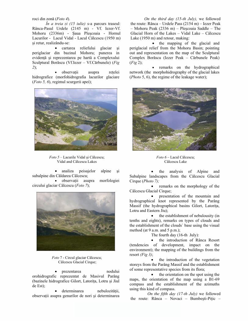
roci din zon (Foto 4).În a treia zi (15 iulie) s-a parcurs traseul:
Rânca-Pasul Urdele (2145 m) - Vf. Iezer-Vf. Mohoru (2336m) - aua Ple coaia - Hornul Lacurilor - Lacul Vidal - Lacul Câlcescu (1950 m) i retur, realizându-se:
cartarea reliefului glaciar iperiglaciar din bazinul Mohoru; punerea in eviden i reprezentarea pe hart a Complexului Sculptural Bor scu (Vf.Iezer – Vf.C rbunele) (Fig 2);
observa ii asupra re elei hidrografice (morfohidrografia lacurilor glaciare (Foto 5, 6), regimul scurgerii apei);
Foto 5 – Lacurile Vidal i Câlcescu; Vidal and Câlcescu Lakes
analiza peisajelor alpine isubalpine din C ldarea Câlcescu;
observa ii asupra morfologiei circului glaciar Câlcescu (Foto 7);
Foto 7 - Circul glaciar Câlcescu; Câlcescu Glacial Cirque;
prezentarea nodului orohidrografic reprezentat de Masivul Parâng (bazinele hidrografice Gilort, Latori a, Lotru i Jiul de Est);
determinarea nebulozit ii,observa ii asupra genurilor de nori i determinarea
On the third day (15-th July), we followed the route: Rânca – Urdele Pass (2154 m) – Iezer Peak – Mohoru Peak (2336 m) – Ple coaia Saddle – The Glacial Horn of the Lakes – Vidal Lake – Câlcescu Lake (1950 m) and retour, making:
the mapping of the glacial and periglacial relief from the Mohoru Basin; pointing out and representation on the map of the Sculptural Complex Bor scu (Iezer Peak – C rbunele Peak) (Fig 2);
remarks on the hydrographical network (the morphohidrography of the glacial lakes (Photo 5, 6), the regime of the leakage water);
Foto 6 – Lacul Câlcescu; Câlcescu Lake
the analysis of Alpine and Subalpine landscapes from the Câlcescu Glacial Cirque (Photo 7);
remarks on the morphology of the Câlcescu Glacial Cirque;
presentation of the mountain and hydrographical knot represented by the Parâng Massif (the hydrographical basins Gilort, Latori a,Lotru and Eastern Jiu);
the establishment of nebulousity (in tenths and eights), remarks on types of clouds and the establishment of the clouds` base using the visual method (at 9 a.m. and 5 p.m.);
The fourth day (16-th July): the introduction of Rânca Resort
(tendencies of development, impact on the environment); the mapping of the buildings from the resort (Fig 3);
the introduction of the vegetation storeys from the Parâng Massif and the establishment of some representative species from its flora;
the orientation on the spot using the maps, the orientation of the map using a B1-69 compass and the establishment of the azimuths using this kind of compass.
On the fifth day (17-th July) we followed the route: Rânca – Novaci – Bumbe ti-Pi ic –
64
în l imii bazei norilor prin metoda vizual (orele 9 i 17 ).
În cea de-a patra zi (16 iulie) s-a urm rit:
prezentarea sta iunii Rânca (tendin e de dezvoltare, impact asupra mediului); cartarea construc iilor din sta iune (Fig 3);
prezentarea etajelor de vegeta iedin Masivul Parâng i determinarea unor specii reprezentative din flora spontan a acestuia;
orientarea în teren cu ajutorul h r ii, orientarea h r ii cu ajutorul busolei tip B1-69 i determinarea azimutelor cu aceast busol .
În cea de-a cincea zi (17 iulie) s-a parcurs traseul: Rânca – Novaci – Bumbe ti-Pi ic -M ld re ti – Horezu – M n stirea Hurezi – Bistri a– M n stirea Bistri a – Muzeul Trovan ilor de la Coste ti – Man stirea dintr-un Lemn (comuna Frânce ti) – B beni – Dr g ani – G neasa – Bal –Craiova, realizându-se:
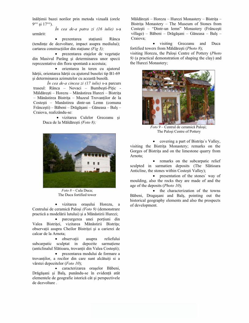
vizitarea Culelor Greceanu iDuca de la M ld re ti (Foto 8);
Foto 8 – Cula Duca; The Duca fortified tower
vizitarea ora ului Horezu, a Centrului de ceramic Palo i (Foto 9) (demonstrare practic a model rii lutului) i a M n stirii Hurezi;
parcurgerea unei por iuni din Valea Bistri ei, vizitarea M n stirii Bistri a; observa ii asupra Cheilor Bistri ei i a carierei de calcar de la Arnota;
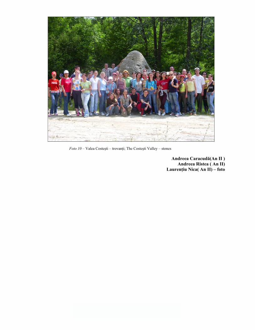
observa ii asupra reliefului subcarpatic sculptat in depozite sarma iene(anticlinalul Sl tioara, trovan ii din Valea Coste ti);
prezentarea modului de formare a trovan ilor, a rocilor din care sunt alc tui i si a vârstei depozitelor (Foto 10);
caracterizarea ora elor B beni, Dr g ani i Bal , punându-se în eviden atât elementele de geografie istoric cât i perspectivele de dezvoltare .
M ld re ti – Horezu – Hurezi Monastery – Bistri a –Bistri a Monastery – The Museum of Stones from Coste ti – “Dintr-un lemn” Monastery (Frânce ti village) – B beni – Dr g ani – G neasa – Bal –Craiova;
visiting Greceanu and Duca fortified towers from M ld re ti (Photo 8);visiting Horezu, the Palo i Centre of Pottery (Photo 9) (a practical demonstration of shaping the clay) and the Hurezi Monastery;
Foto 9 – Centrul de ceramic Palo i; The Palo i Centre of Pottery
covering a part of Bistri a`s Valley, visiting the Bistri a Monastery; remarks on the Gorges of Bistri a and on the limestone quarry from Arnota;
remarks on the subcarpatic relief sculpted in sarmatien deposits (The Sl tioara Anticline, the stones within Coste ti Valley);
presentation of the stones` way of moulding, also the rocks they are made of and the age of the deposits (Photo 10);
the characterization of the towns B beni, Draga ani and Bal , pointing out the historical geography elements and also the prospects of development.
65
Foto 10 – Valea Coste ti – trovan i; The Coste ti Valley – stones
Andreea Caracud (An II ) Andreea Ristea ( An II)
Lauren iu Nica( An II) – foto

66
APLICA IA PRACTIC A ANULUI II ÎN DELTA DUN RII
THE SECOND YEAR STUDENTS’ FIELD TRAINING WITHIN THE DANUBE DELTA
Devenit tradi ie, deplasarea în Delta Dun rii pentru realizarea de aplica ii practice, îi mobilizeaz pe studen ii anului II ai specializ rii Geografie a Facult ii de Istorie-Filosofie-Geografie a Universit ii din Craiova, în fiecare lun iulie, ca un epilog al sesiunii de var . Timp de o s pt mân , studen ilor i cadrelor didactice îndrum toare le este oferit prilejul savur rii concrete a spectacolului perpetuu al naturii pe care îl abordeaz doar teoretic în laboratoare i s lile de curs.
Desf urat în perioada 2. VII. – 8. VII. 2005, aplica ia practic a avut ca scop cunoa terea nedistorsionat a “celui mai nou p mânt românesc” de c tre studen ii facult ii, dar i a inuturilor traversate: Câmpia Român , Podi ul Dobrogei de Nord i completarea informa iilor dobândite teoretic.
Transportul celor 65 de studen i i al profesorilor a fost asigurat de autocar pân la Tulcea, de vapor pân la Sulina i de cele doualupe , în interiorul Deltei, tot traseul fiind
pigmentat de informa iile domnilor profesori îndrum tori lect. univ. drd. Cornel Golea i asist. univ. drd. Ionu Marinescu, iar cazarea a fost asigurat la Tulcea i Sulina, în taberele colare.
Ca de fiecare dat , drumul s-a dovedit a fi la fel de interesant ca i obiectivul final al aplica iei, nu trebuie decât s ii ochii deschi ipentru a vedea lucruri care merit v zute: culoarele fluviatile i sistemele de terase ale Oltului, Arge ului, Ialomi ei, capitala (cu oprire pentru vizitarea celui mai mare muzeu de tiin e ale naturii din ar , Muzeul Antipa), Valea Dun rii în zona Hâr ova, podi urile Casimcei i Babadag.
Punctul de plecare al adev ratei aventuri (conceput în sistem radiar – tab r cu plec ri în fiecare zi) a fost ora ul Tulcea (Foto 1), cea mai important citadel a Dobrogei de Nord oraaproape la fel de vechi ca i Roma. Situat în apropiere de bifurcarea Dun rii, Tulcea reprezintprincipalul punct de preg tire pentru a p trunde în universul Deltei Dun rii.
Cea de-a doua zi (3 iulie) a avut ca scop dezv luirea peisajelor reliefului nord-dobrogean ia unei civiliza ii aparte, marcat de multiple influen e: Podi ul Niculi el, Rezerva ia Luncavi a,
Having already become a tradition, going to the Danube Delta for the purpose of practically applying theoretical knowledge, mobilizes 2nd year Geography students from the History – Philosophy – Geography Faculty from the University of Craiova, each July, like a true epilogue of the summer examination period. For a whole week students and teachers get to have real touch of the perpetual show of the natural world they have been theoretically approaching in laboratories and classes.
Having taken place between the 2nd and the 8th of July 2005, the didactical application was meant to give the students the opportunity to know “the newest piece of Romanian land“ and the territories they were crossing as truly as possible: The Romanian Plain and The Northern Dobrogea Plateau and to enhance their theoretically acquired knowledge.
The 65 students and their professors travelled by bus to Tulcea, by boat to Sulina and by two motorboats inside The Delta. The whole route was given colour by the information provided by the teacher-guides, professor Cornel Golea and professor Ionu Marinescu, while the accommodation was provided by the summer camps in Tulcea and Sulina.
As every time, the journey itself proved to be just as interesting as the final objective of the trip: all you had to do was to keep your eyes wide open for the things worth seeing: the fluvial couloirs and the terrace systems of the Olt, Arge , and Ialomi arivers, the capital city (a visit to the country’s greatest museum “The Antipa Museum”), The Valley of the Danube in The Hâr ova area, The Babadag and Casimcea Plateaus
The starting-point of the real adventure (conceived in a radial way – daily departures from the camp) was Tulcea, the most important city of Northern Dobrogea, almost as old as Rome, situated near the point were the Danube splits in its three main branches. Tulcea represents the main point of entering the universe of the Danube Delta.
The second day (the 3rd of July) brought the revelation of Northern Dobrogea’s unique landscapes and civilization, strewn with multiple influences: The Niculi el Plateau, Luncavi a

67
Lunca Dun rii neamenajat , Depresiunea Nalbant. Ascensiunea pe cel mai înalt punct al Dobrogei (vârful u uiatu din Masivul M cinului) le-a reamintit studen ilor de traseele montane escaladate. Au fost vizitate localit ile Isaccea, M cin, Greci, Babadag (al carui punct de interes l-a reprezentat moscheea – Ali-Gaza-Pa a.
Reservation, the wild Danube meadow, The Nalbant Depression. The ascent to the highest peak of Dobrogea ( u uiatu Peak of The Mãcin Massif) reminded the students of the previous ascensions. Several localities in the area such as Isaccea, Greci, Babadag (whose main interest was the mosque Geamia Ali-Gaza-Pa a) were visited.
Foto 1 - Ora ul Tulcea; City of Tulcea
În 4 iulie, grupul a pornit s patrundcâteva dintre fascinantele taine ale Deltei Dun rii,pe bra ele Tulcea i Sulina ( Foto 2 ), între ora ele omonime. Acum studen ii au f cut cuno tin cu elementele protejate de flor i faun din cadrul Rezerva iei Biosferei Delta Dun rii. Fiind sezon estival, nu po i s nu te delectezi cu por iunea de litoral a ora ului Sulina.
Cea de-a patra zi a reprezentat punctul culminant al aplica iei, deplasarea prin locurile de o atrac ie molipsitoare pentru fiecare iubitor de natur : canalele interdeltaice, ecosistemele delataice din delta fluvio-maritim (cu faun ivegeta ie având valoare de unicat), localit ile pe cât de izolate, pe atât de enigmatice:Cardon, Sfi tofca, C.A. Rossetti, Letea (satele, unde singurele c i de acces sunt canalele care le strabat, par a fi neatinse de trecerea timpului).
A fost vizitat aria protejat Letea cu rezerva ia forestier Hasmacul Mare i relieful de dune dar i colonia de pelicani (Foto 3) din Golful Musura.
On the 4th of July the group began uncovering some of the fascinating secrets of The Danube Delta, exploring The Tulcea and Sulina Branches (Photo 2) between the homonymous towns. The students met with protected elements of flora and fauna from The Danube Delta. Biosphere Reserve. As it was the middle of the summer season, you could but take delight in the Sulina seacoast.
The 4th day represented the climax of the expedition which meant visiting places of incredible attraction for a nature lover: the canals from within The Delta, the deltaic ecosystems (having unique species of fauna and vegetation), the isolated and enigmatical localities of Cardon, Sfi tofca, C.A. Rossetti, Letea (the villages, to which the only way of access is represented by the canals, seem to have remained untouched by the passage of time).
The protected Letea area with its forestry reservation of Hasmacul Mare and its dunes as well as the pelican colony (Photo 3) of Musura Bay have been visited.

68
Foto 2 - Cu alupa pe canalele Dun rii ; With the motorboat on the Delta’s canals
Foto 3 - Colonia de pelicani din golful Musura ; The pelican colony of Musura Bay
În propor ie de 80%, în condi iile naturale, acest teritoriu era domeniul gârlelor, japselor, lacurilor, stuf ri urilor i z voaielor de s lcii care ad posteau specii de insecte, pe ti, p s ri imamifere de o mare diversitate (Foto 4,5) totul datorându-se gra iei i for ei naturii.
Ziua urm toare a fost rezervatcunoa terii ora ului Sulina, unul dintre cele mai interesante ale rii, datorit amplasamentului i a condi iilor de întemeiere. Dintre obiective, enumer m: zona cu func iunile portuare i litorale, cimitirul maritim, farul (Foto 6), punctul de belvedere de pe plaj .
In natural conditions, 80 percent of this territory is made up of streams, low hollows, lakes, reed thickets and willow meadows, home to numberless species of insects, fish, birds and mammals, all owing their incredible diversity (Photo 4, 5) to nature’s grace and force.
The next day was reserved to visiting the town of Sulina, one of the most interesting towns in the country, due to its location and the conditions of its founding. Let’s sum up some of its objectives: the harbor, and the sea coast area, the sailors’ cemetery, the lighthouse (Photo 6) and the sightseeing point on the beach.

69
Foto 4 -Japse ; Low hollows
Penultima zi a reprezentat “piatra de încercare” pentru studen i, deoarece, pe drumul de întoarcere spre Tulcea, pe vapor, s-a desf urat colocviul de verificare. Domnii profesori au fost mul umi i de activitatea studen ilor i i-au r spl tit cu o sear distractiv în cel mai mare ora al Dobrogei de Nord. Condi iile au favorizat vizitarea am nun it a ora ului, a obiectivelor industriale, a Monumentului Eliber rii i a falezei.
The penultimate day represented a “touchstone” for the students, as, on the way back to Tulcea, on the boat, took place the examination. Being satisfied with the students’ results, the professors repaid them with a night out in Northern Dobrogea’s largest town. There were excellent conditions for a detailed sight seeing of the town, of the industrial objectives, of the Liberation Monument and of the seawall.
Foto 5 - Biodiversitate; Biodiversity

70
Ziua întoarcerii (8 iulie) a fost marcat de vizitarea unuia dintre cele mai importante obiective turistice ale rii, Casa Poporului, cel mai mare edificiu al capitalei (Foto 7). S-a parcurs acela itraseu, traversând subunit ile Câmpiei Române iobservând particularit ile geomorfologice, tipurile de a ez ri i modul de utilizare a terenurilor.
O excursie în Delt va r mâne o amintire de neuitat din toate punctele de vedere. Sunt locuri despre a c ror frumuse e cel mai bine pot povesti ochii celor care le-au v zut.
Succesul acestei aplica ii este cu atât mai tonic, cu cât pe lâng atingerea scopurilor didactice intite, a reprezentat i o manier de reconfortare,
de relaxare, de revigorare psihic a grupului, dupsesiunea de examene recent încheiat
The return day (the 8th of July) was marked by the visit to one of the country’s most important touristic objectives, Casa Poporului (The People’s House- Photo 7), the most impressive building of the capital. On their way back they travelled through the same geographical units, through the subunits of the Romanian Plain and were able to notice its geomorphologic particularities, its types of settlements and the different ways in which the terrain is used.
A trip to the Delta will forever remain an unforgettable memory from all points of view. There are places for which the best storyteller is represented by the eyes of the beholder.
The success of such an application was all the more invigorating, as, apart from attaining the didactical aims, it represented a way of strengthening, relaxation and psychical recharge of the group, well deserved after the recently finished summer examinations.
B loi Ionu Cosmin (Anul III ID) Chelu Corina-Maria ( Anul III )
Idi oiu Radu (Anul II )
Foto 6 - Vechiul far; The old lighthouse
Foto 7- Casa Poporului; The People’s House